All Activity
- Past hour
-

Friday February 6 FROPA / WINDEX small event
weatherwiz replied to HoarfrostHubb's topic in New England
That is pretty insane to see. That would probably be a legit thunderstorm with 4" per hour rates lol. Maybe some waterspouts too -

February 2026 OBS & Discussion
Freezing Drizzle replied to Stormlover74's topic in New York City Metro
I had commented that my humidifier has been running non-stop most of this winter, just to keep the interior RH to 35% -
NWS taking the wind threat seriously talking about widespread power outages. Widespread power outages at 10 degrees is no bueno. Do we really think that 60 mph gusts are gonna mix down tomorrow? I am hoping not.
-
Yea the burst on the front is what I was asking about. The evening snow today seems associated with a lead shortwave
-
It has been a little bit cold lately. https://x.com/i/status/2019537040808046913
-

Friday February 6 FROPA / WINDEX small event
NeonPeon replied to HoarfrostHubb's topic in New England
Narragansett Bay snow hole accurately modeled... Lock it in. -
I know. Thought we would keep the cloud cover from the morning. But of course the sun comes out. Sigh. Waiting for some snow TV.
-
February 2026 OBS & Discussion
Freezing Drizzle replied to Stormlover74's topic in New York City Metro
Here on the north NJ coast, most winters, over the decades, do not have snowfall on snow. -
Not used to seeing this forum get heated! Yes there was a warm stretch for a few weeks around the holidays but it’s been cold and dry for the most part this winter. It would have been nice to have a little more moisture during this cold phase but there’s more chances coming.
-
It’ll be a nowcast situation I think, we’ll have to see how the moisture regenerates east of the mountains. Hopefully we get a couple inches to freshen up the snowpack.
-
Maybe? I haven't looked at the mechanics of why this band is way out ahead of the actual arctic boundary. Another possibility is a few scattered bursts of snow right on the late night front....
-

Friday February 6 FROPA / WINDEX small event
dendrite replied to HoarfrostHubb's topic in New England
We’re not trying to pop supercells in June here. That’s pretty unstable for snowfall. -
14 this morning. High res models showing a decent hit of snow for Suffolk county. NAM has 2-4” from west to east. HRRR and Euro more in the 1-2” range
-
Really the past two years as a whole have been dry. Aside from May 2025, we've seen near or below average precipitation.
-
Light snow just started here. 22/12.
-

Friday February 6 FROPA / WINDEX small event
Torch Tiger replied to HoarfrostHubb's topic in New England
highway crews dropping tons of salt and spray here lol. what a waste -

Southern MD / Lower Eastern Shore weather discussion
csnavywx replied to PrinceFrederickWx's topic in Mid Atlantic
Should finally get some flakes this evening/overnight. Not much but we take what we can get around here. Big gale tomorrow. Most of these wind estimates are lowballed, imo. Full sun, very strong CAA and a bombing low offshore should be more than enough to pull down momentum from aloft and make for some very strong gusts (50-55KT inland, approaching 60 at times near/over water). Depends on how deep the mixing layer actually gets. -

Friday February 6 FROPA / WINDEX small event
40/70 Benchmark replied to HoarfrostHubb's topic in New England
Expect a couple of inches and no one will be dissapointed. It's on a weekend...bring the refresher IMO. -

Pittsburgh/Western PA WINTER ‘25/‘26
Burghblizz replied to Burghblizz's topic in Upstate New York/Pennsylvania
I still have close to 10” in my yard, so any snow on snow is good. Interesting to see if that secondary squall line develops this evening -
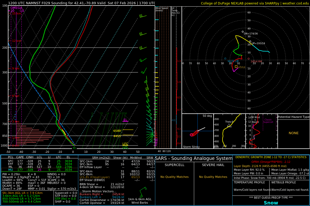
I asked Chat GPT to give me a hand with this one - how do you think it did? "There’s a little bit of instability offshore, but strong upward motion in the part of the atmosphere where snow forms, which means good potential for precipitation (especially snow) even though the overall energy isn’t very high."
-
 I only got to -4° but I had to run an errand that took me through other parts of northern VT and I saw as low as -10° on the car thermo. -6° when I passed the MVL ASOS around 8:00am
 -
I picked up a quick 2" this morning as the snow is winding down. Back up to 5" on the ground. Had to take the wife to FWA at 5:30 and had graupel covering the road. Dropped her off at a little after six when it flipped to SN. Her 7:20 flight is still sitting on the tarmac. I'll bet she's pissed.
-
Think we can get the snow band to hang on over the mountains with it? Euro and NAM have hinted at it…
-
Friday February 6 FROPA / WINDEX small event
dendrite replied to HoarfrostHubb's topic in New England
Pushing 200 joules of SBCAPE just offshore with big low/mid level omega in the DGZ.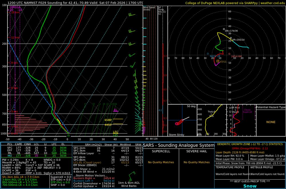
-
12z IAD sounding shows a very dry 850 mb layer. Rest of the column is “normal” in terms of dew point depression.


.thumb.jpeg.f5c6ba9d911ec96b3b124f8606aee58e.jpeg)