All Activity
- Past hour
-
Watch out Azores Hurricane Gabrielle Discussion Number 25 NWS National Hurricane Center Miami FL AL072025 1100 PM AST Mon Sep 22 2025 Gabrielle remains a formidable Category-4 hurricane with a well-defined 15 n-mi diameter eye surrounded by very cold cloud tops of near -70 deg C. The current intensity estimate is held at 120 kt, which is slightly higher than the latest subjective Dvorak estimates of 115 kt from both TAFB and SAB. This is also a blend of objective estimates from UW-CIMSS. The hurricane has turned toward the northeast and is now moving at around 040/11 kt. The track forecast philosophy remains about the same as in the previous advisory. Gabrielle should move around the northwestern side of a mid-level subtropical ridge during the next day or so and then accelerate east-northeastward between the ridge and the mid-latitude westerlies through about 72 hours. A slight turn to the northeast ahead of a higher-latitude trough is expected in 3-4 days. This official track forecast is similar to the previous one. The latest Google DeepMind forecast is a little farther north of the model consensus. Simulated satellite imagery from the global models suggest extratropical transition will occur on Friday while the system is in the vicinity of the Azores. No significant change in intensity is anticipated into early Tuesday while Gabrielle remains in a conducive atmospheric and oceanic environment By late tomorrow and beyond, increasing vertical wind shear, drier mid-level air and cooler waters should cause weakening. However, an approaching upper-level trough could provide enhanced divergence aloft which could help Gabrielle maintain some of its intensity during the next few days. The official intensity forecast is similar to the previous one and close to the model consensus. KEY MESSAGES: 1. Swells generated by Gabrielle will continue to affect Bermuda and the east coast of the United States from North Carolina northward, as well as Atlantic Canada, during the next couple of days. These swells are likely to cause life-threatening surf and rip current conditions. Please consult products from your local weather office. 2. Gabrielle is forecast to approach the Azores late on Thursday. Interests in the Azores should monitor the progress of Gabrielle though it is too soon to specify the magnitude of potential wind, rainfall, and wave impacts. FORECAST POSITIONS AND MAX WINDS INIT 23/0300Z 32.4N 61.0W 120 KT 140 MPH 12H 23/1200Z 33.5N 59.1W 120 KT 140 MPH 24H 24/0000Z 34.8N 55.4W 110 KT 125 MPH 36H 24/1200Z 35.5N 50.3W 100 KT 115 MPH 48H 25/0000Z 35.9N 44.5W 90 KT 105 MPH 60H 25/1200Z 37.0N 37.7W 80 KT 90 MPH 72H 26/0000Z 38.8N 31.5W 70 KT 80 MPH 96H 27/0000Z 43.0N 22.9W 55 KT 65 MPH...POST-TROPICAL 120H 28/0000Z 44.0N 16.0W 45 KT 50 MPH...POST-TROP/EXTRATROP $$ Forecaster Pasch
-
Fire Harbaugh for shits sake. This isn't rocket science. This team cant run the ball with a mediocre OL and a big back with no quickness- who now has a fumble problem. And the defense makes no big plays.
-
What a killer turnover
-
Henry has fallen off the cliff. Where is Mitchell?
-
That round finally held together and gave me a good hour of rain.
-
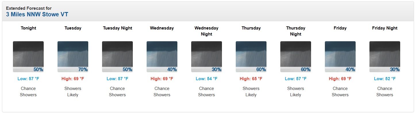
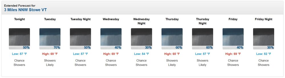
Have a big outdoor event up here on Signal Mountain tomorrow evening. Looks like possibility of a shower rolling through around 7 pm. Low overall %. How likely is it something develops tomorrow between 5 and 8 pm, and if it does, will it move through quickly? .
- Today
-
Wow. Glad you’re ok. I can’t even imagine being in that situation.
-
Oh, what the hell! Let's fire up the SVR thread for perhaps its last hurrah of 2025. MRGL for tomorrow - the shear/instability combo isn't great, but I could see a few decent wind gusts. Will be very happy with thunder and heavy rain. The CAMs today mostly favored DC and points south, but the HRRR has kicked off the evening suite by favoring generally north of DC.
-
Took the doggo on a two mile night walk and can definitely feel the humidity creeping in. Feels nice this time of year.
-
Jeezuz, glad you are ok! Life altering experience for sure. Quick thinking, nice work. My ADD mind is always planning worst case scenario escapes.
-
Defense doesnt have a clue either.
-
Monken.
-
FFS
-
 Well unexpectedly Gabrielle did intensify all the way to major (cat 4) so I have modified the table of storms required. Will probably be modifying it again soon to get the 8th named storm into the table.
 -
Lack of sun icons in the forecast.
-
A great big October wet snow bomb would be just what the doctor ordered to usher in a new weather paradigm. The past 3 years have been the most boring of my life weather wise Sent from my SM-G970U1 using Tapatalk
-
September 2025 OBS-Discussion centered NYC subforum
Roger Smith replied to wdrag's topic in New York City Metro
The snow depth mystery is basically explained by fact that snow depth is measured early in the day before most of the snow falls, so it increases the day after the snowfall report in most cases. -

September 2025 OBS-Discussion centered NYC subforum
Sundog replied to wdrag's topic in New York City Metro
I remember being on the bus waiting for a kid to get on in 1994 when we went below zero and as we were waiting, some store clerk came outside with a bucket of water and he poured it toward the sewer down the side of the street and the water never made it since it froze in seconds. -
I wonder if this will continue into winter. Any thoughts? I know a lot of our troubles the last ten years have been from too much MJO 4-6. So maybe no real MJO signal would be a plus?
-

September 2025 OBS-Discussion centered NYC subforum
gravitylover replied to wdrag's topic in New York City Metro
I never lived far enough from a school to take the bus. There were some crazy cold walks and the wind off the water was always in your face. The good old days... -
This could be an old school big 12 sorta game. No defense and two high powered offenses.
-
Happy actual Fall everyone! I am looking forward to tracking our first frost & first flakes.
-
4th and 3, why are they playing 10 yds off the WR's? Absolutely horrible defensive play calling.
-
Finally some really good rains here In middle TN.
-
Absolutely zero pass rush


.thumb.png.4150b06c63a21f61052e47a612bf1818.png)