All Activity
- Past hour
-

September 2025 OBS-Discussion centered NYC subforum
TheClimateChanger replied to wdrag's topic in New York City Metro
Looking at the observations from Pittsburgh (PIT), it appears to be about a 1F cooling offset. But YMMV by location - definitely something to keep an eye out for. In June 2024, PIT was 72.8F, which was 3.9F above the Pennsylvania Southwest Plateau mean of 68.9F. In June 2025, PIT was 73.1F, which was 2.9F above the Pennsylvania Southwest Plateau mean of 70.2F. In July 2024, PIT was 76.5F, which was 3.3F above the Pennsylvania Southwest Plateau mean of 73.2F. In July 2025, PIT was 77.0F, which was 2.3F above the Pennsylvania Southwest Plateau mean of 74.7F. So it looks like relative to the Climate Division in which it is located, the new sensor shaved off 1F. Of course, the WBAN sites make up a decent proportion of the total stations in nClimDiv such that the offset may bias the divisional means unless it's been corrected by the pairwise homogenization algorithm. But if there is a residual bias in the divisional data, then the actual cooling offset may be a bit more than 1F. This is a big reason why state and divisional rankings were higher this summer than the cities, as the cooperative sites [and other stations] had no change in equipment and thus had more continuity of record. This is a reversal of recent years/decades in which cities tended to rank higher than the corresponding state and divisional data. -
Low of 45.6°
-
Yeah…through d9 lol
-
Yeah I think we have to punt away this season and hope and pray Biscotti finally does what needs to be done. I came into this year skeptical about it being the SB year to begin with--so while it's disappointing it's not surprising!
-
Thursday and Saturday rainfall totaled just .37" here. (.02" on Saturday)
-
September 2025 OBS-Discussion centered NYC subforum
TheClimateChanger replied to wdrag's topic in New York City Metro
Do you think the new sensors are playing a role in the explosion of record lows? It's been wild to see these airports go from way warmer than everywhere to colder. 100% humidity observations went from basically non-existent to now I'm seeing some of these rural airports having eight hours a night at 100% with no weather (fog, precipitation). -
I think that is also BN too. Erin spiked it up, but we’ve had garbage outside of that.
-

2025-2026 ENSO
michsnowfreak replied to 40/70 Benchmark's topic in Weather Forecasting and Discussion
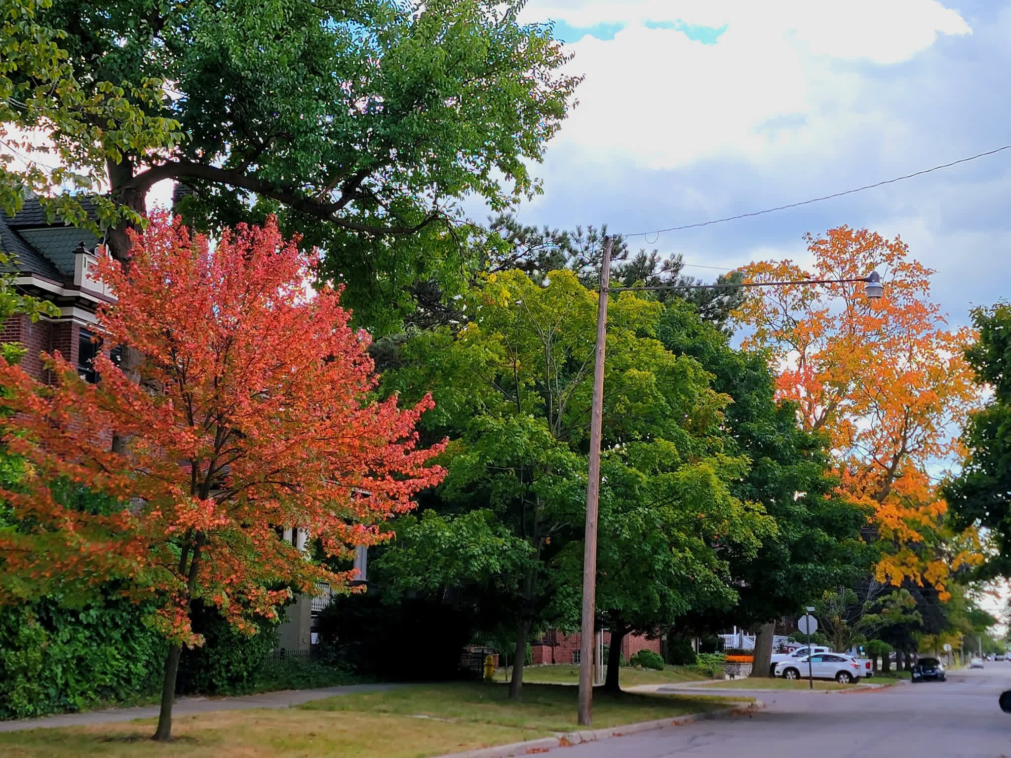
The 2 week period of Aug 25 - Sept 7 (last week of Aug + first week of Sept) was 6th coldest on record for Detroit and coldest since 1935. There is also way more color than usual for early September. Do I really feel there is any correlation to winter? No. But since every warm record is brought up by some as meaning something for winter, figured it was worth a mention .
-

E PA/NJ/DE Autumn 2025 Obs/Discussion
soadforecasterx replied to PhiEaglesfan712's topic in Philadelphia Region
Received 0.97" over the weekend. It was a nice a steady rain too. Now back to our dry pattern. -
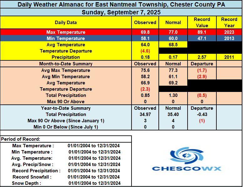
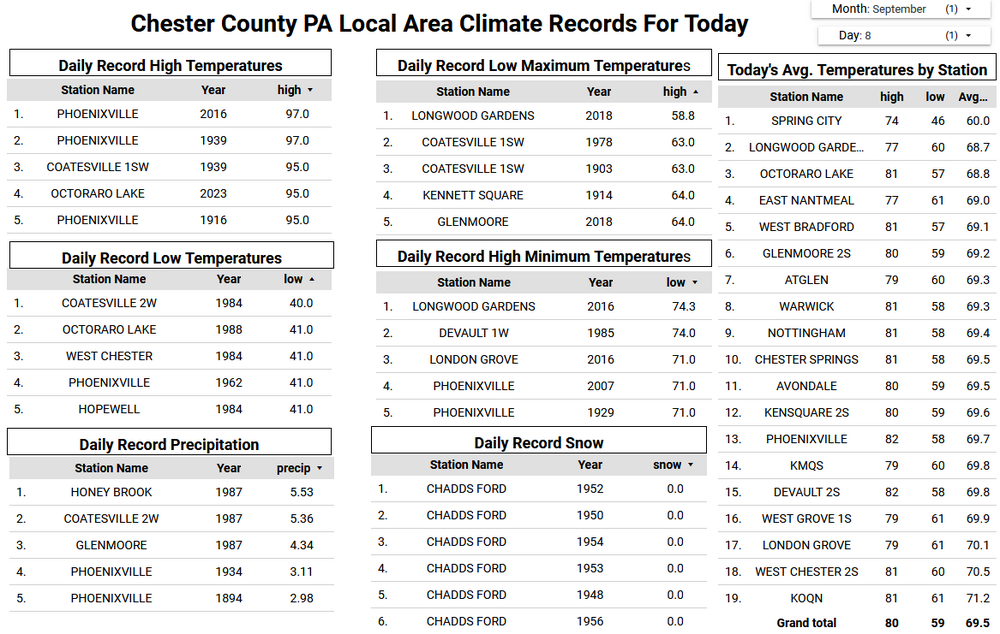
A beautiful early autumnal string of weather days this week. Many spots, especially in the valley locations across the county, saw low temperatures again in the 40's. Those same spots should see similar reading for much of the rest of the week with higher spots at least down into the lower 50's. Daytime highs will be below normal through Wednesday with temperatures getting slightly above normal in the upper 70's by Thursday before falling back to near normal in the mid 70's by the end of the week. Unfortunately, no rain appears possible through this week.
-
(002).thumb.png.6e3d9d46bca5fe41aab7a74871dd8af8.png)
E PA/NJ/DE Autumn 2025 Obs/Discussion
ChescoWx replied to PhiEaglesfan712's topic in Philadelphia Region
A beautiful early autumnal string of weather days this week. Many spots, especially in the valley locations across the county, saw low temperatures again in the 40's. Those same spots should see similar reading for much of the rest of the week with higher spots at least down into the lower 50's. Daytime highs will be below normal through Wednesday with temperatures getting slightly above normal in the upper 70's by Thursday before falling back to near normal in the mid 70's by the end of the week. Unfortunately, no rain appears possible through this week.
-
A bit over 1" from Saturday's event, including some Sunday leftovers. Raised the Sandy River by 0.15 feet, still under the 25th percentile and headed back down. First fire in the stove in nearly 3 months this morning - low of 41 after yesterday's cloudy drippy high of 59.
-
Not really convinced these temperatures are accurate, but 30F was observed at Zelienople Municipal Airport.
-
Exactly. Theres always a few stressed trees showing color by late August, but the amount of color for early September is clearly more than normal this year. 45F again at DTW. Its incredible how many upper 30s and low 40s the cold spots of SE MI have had the past 2 weeks. The period of Aug 25 - Sept 7 (the last week of Aug & first week of Sept) was 6th coldest on record for Detroit, and coldest since 1935.
-

Central PA Summer 2025
Mount Joy Snowman replied to Voyager's topic in Upstate New York/Pennsylvania
Low of 48. Official tally from the overnight Saturday/Sunday early morning rain was .12”. The weather gods again treating us too kindly this week. -

September 2025 OBS-Discussion centered NYC subforum
wdrag replied to wdrag's topic in New York City Metro
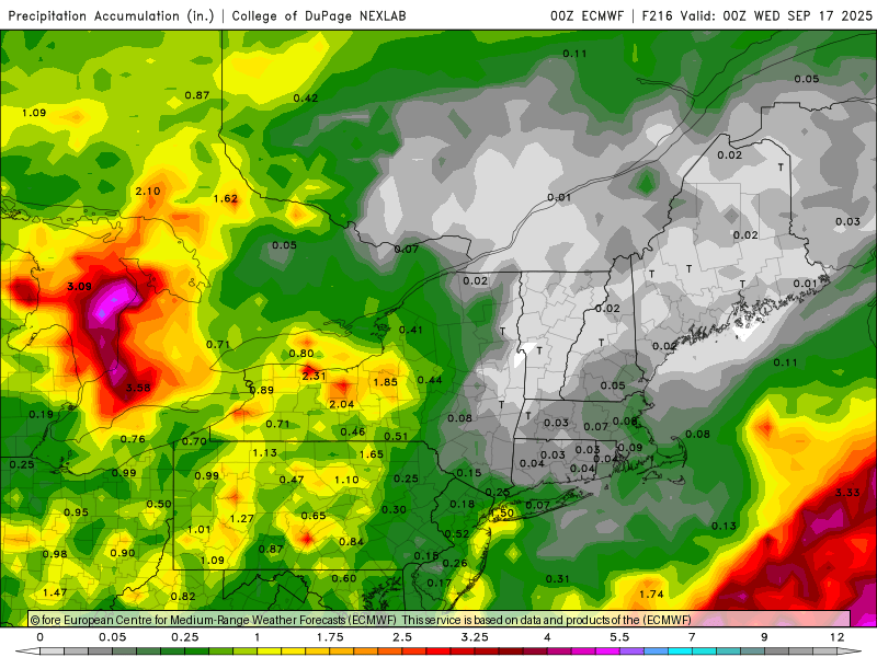
Regarding LR: Complications for Wed-Fri, could result in some periodic rain for the coasts and at the least lots of clouds. Overall: I didnt check recent dryness, but already sw Canada seems to have been burning for a while and from what I can tell, excessive heat spreads eastward, north of the Great Lakes. My guess is lots of smokey sky in our future next week when the pattern at mid levels seems to encourage sewd drift of sw Canada smoke. That does not translate to near surface aerosol complications but visually, I 'think' we're headed to a return of smoky sky. -
September 2025 General Discussion
TheClimateChanger replied to Geoboy645's topic in Lakes/Ohio Valley
28F at the Water Treatment Plant in Wauseon yesterday. -

September 2025 OBS-Discussion centered NYC subforum
psv88 replied to wdrag's topic in New York City Metro
51.0 -

September 2025 OBS-Discussion centered NYC subforum
MANDA replied to wdrag's topic in New York City Metro
Just entered my CoCoRaHs obs. My 9/5 to 9/8 total was 2.5". Much needed. Beautiful chilly morning with a low of 46. Lowest I've seen is Sandyston, NJ at 40. -

September 2025 OBS-Discussion centered NYC subforum
jm1220 replied to wdrag's topic in New York City Metro
Much needed here for sure. Thanks as always for the analysis! -
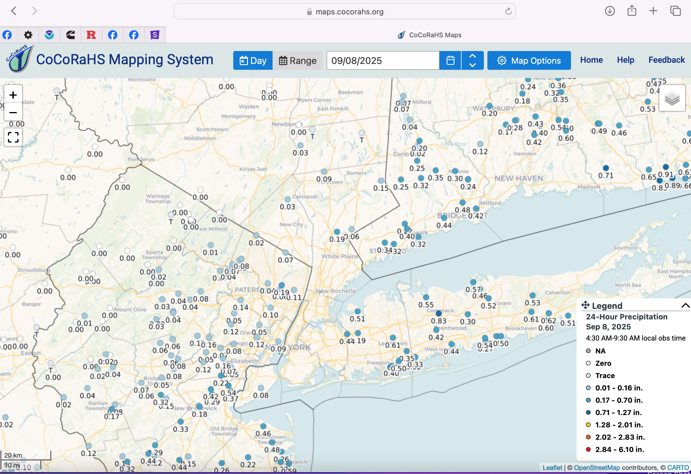
September 2025 OBS-Discussion centered NYC subforum
wdrag replied to wdrag's topic in New York City Metro
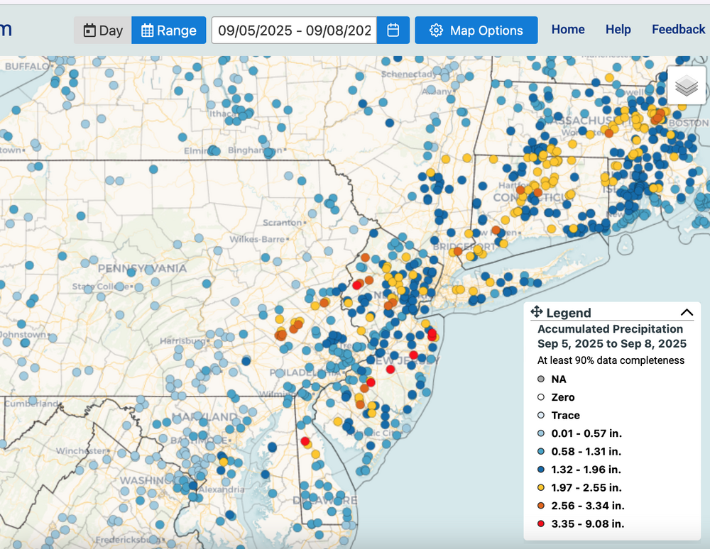
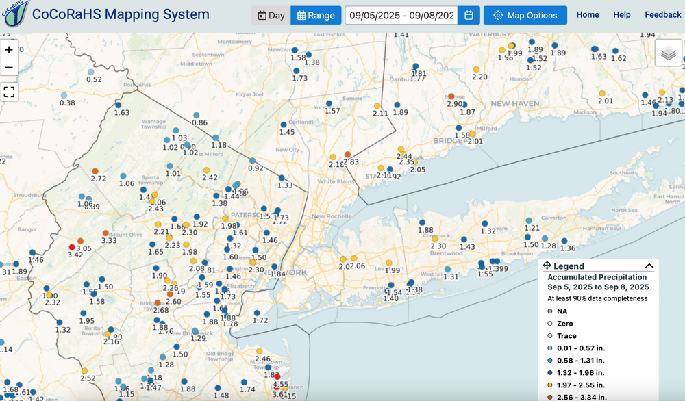
CoCoRaHs summary late Fri, late Sat-Sun events... should help lower drought classification by one, that we will see Thursday. Note the whole NYC subforum did very well... max axis near I95, give or take. E Li you did aok. Click for clarity the sunDAY leftovers, the Fri-Sun broad look (reds the heaviest), and then the detailed bulk NYC subforum.
-
I’ll sell that stretch.
-

O'Brother Septorcher
Prismshine Productions replied to Prismshine Productions's topic in New England
Only .84 over the weekend... Damn Sent from my SM-S166V using Tapatalk - Today
-

September 2025 OBS-Discussion centered NYC subforum
uofmiami replied to wdrag's topic in New York City Metro
49.1 in Muttontown & 51.4 in Syosset this morning. -

September 2025 OBS-Discussion centered NYC subforum
FPizz replied to wdrag's topic in New York City Metro
46.8, nice.