All Activity
- Past hour
-
Warming events taking place at both the North Pole and the South Pole with assist the MJO in progressing into phase 8 in December.
-
Didn't Webb say the - NAO was going to lock in ?
-
35.6 for the low. currently sitting at 41.2 here in 21057
-
Correct me if I'm wrong, but essentially what you're saying is that we’ll probably still get colder later in December, but the pattern is now looking less “textbook perfect” than it did before; it looks more like a pattern driven mainly by the MJO rather than a more powerful and sustained cold setup from both the Pacific and the Atlantic.
-

Pittsburgh PA Fall 2025 Thread
TheClimateChanger replied to TheClimateChanger's topic in Upstate New York/Pennsylvania
It's been an incredible 1,348 days since the last calendar day with 4" of snow. You have to think eventually that breaks, or do you guys think it is no longer possible to see 4" of snow in a single day at PIT? -
The Pacific looks good with MJO going through Phase 7 and possibly Phase 8.. models are developing and have trended toward a +PNA pattern. The Atlantic was looking blocky earlier in the month and that was exciting because it was associated with a Stratosphere warming to help sustain the pattern until possibly early January. In the last few days a big +NAO appeared in the medium range, and the 10mb warmings doesn't look as strong, although it's still a Strat warming happening. We will probably get colder later in the month, but it kind of has a bad taste when the fundamentals were looking so good, now it's just a MJO-amped pattern and nothing more. By fundamentals I mean holding a -NAO for more than 10 days.
-
Is December looking less and less good (because it seems like the beginning of the month has trended warmer), or is it just models rushing the pattern change like usual?
-

November 2025 general discussions and probable topic derailings ...
tamarack replied to Typhoon Tip's topic in New England
Low here was 14, coldest of the season by 6° but nothing special for November. Median for November's lowest is 8, range is 17 (twice) and -4. Pure blue and no wind this morning. -
Not going to ignore the big +NAO that came out of nowhere the last few days. A week ago models had persistent -NAO through Nov and Dec, and I think I actually made a few comments about how rare that has been. Almost all -NAO's have lasted only 10 days then gone away or switched positive. Well there it is again. Since 10-11, we haven't had a -NAO Winter for this reason, and 19/19 Winter months with NAO value >1.12 in that time have all been positive! That's the decadal phase we're in. It was looking hopeful that this year would start off different, but that's changed in the last few days.
-
Diabolical 1-95 map and I love that for them
-

November 2025 general discussions and probable topic derailings ...
weatherwiz replied to Typhoon Tip's topic in New England
Can't even get good agreement on models on how tomorrow/tomorrow night evolve -

Central PA Fall Discussions and Obs
pasnownut replied to ChescoWx's topic in Upstate New York/Pennsylvania
thick ass blanket of frost on way to work. F dem ticks... -
Ensembles shows some modest interest in snow/ice for the I84 corridor Thanks giving weekend and a period of advisory wind continues to be on the table.
-
28 here as well. Frost was everywhere.
-
I do too. If they could throw in Norm working out of his New England workshop and a Bob Ross episode, I'd be in heaven.
-
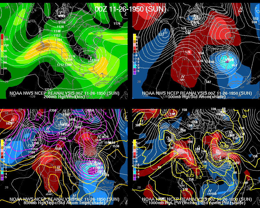
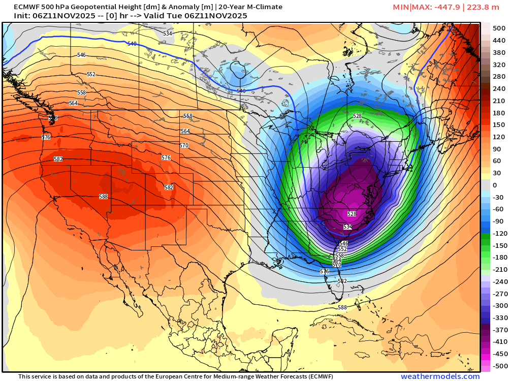
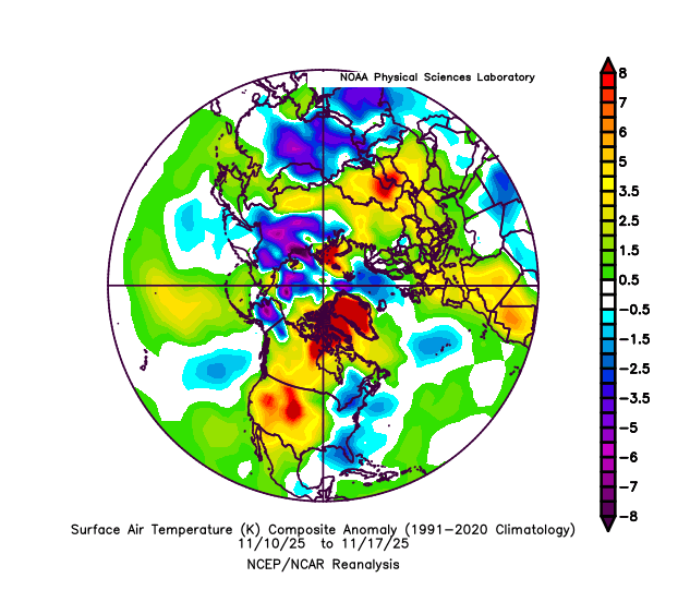
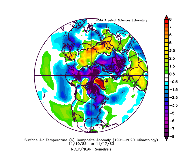
Based on H5 height comparisons (not H5 height anomaly comparisons), I strongly doubt that H5 temps on 11/11/2025 were as cold as those of 11/26/1950: 11/26/1950 0Z: N NC ~520 dm per upper right map 11/11/2025 6Z: N NC 528 dm However, in terms of H5 temperature anomalies for any date in Nov back to 1950, I feel it’s likely because NC H5 ht anomalies on 11/11/2025 were as low as -45 dm vs 11/26/1950’s lowest being ~-41 to -42 dm per the comparisons of these two maps. Had the 11/11/2025 pattern instead occurred 2 weeks later, I believe it likely would have broken the Nov H5 temp. record. Keep in mind that H5 heights are directly related to air temps from H5 down to the surface.
-

Winter 2025-2026 Offers Return to Normalcy
40/70 Benchmark replied to 40/70 Benchmark's topic in New England
-
 1st legit possibility. But still a longshot.
 - Today
-
Records: Highs: EWR: 76 (1985) NYC: 77 (1985) LGA: 75 (1985) JFK: 73 (1985) Lows: EWR: 21 (1984) NYC: 20 (1873) LGA: 23 (1984) JFK: 25 (1896) Historical: 1869 - A second great windstorm in three days struck Vermont and New York blowing railroad trains off their tracks. (David Ludlum) 1900 - An unusual tornado outbreak in the Lower Mississippi Valley resulted in 73 deaths and extensive damage across Arkansas, Mississippi and Tennessee. (David Ludlum) 1914 - The high temperature of 28 degrees at Atlanta, GA, was their earliest daily high below the freezing mark. (The Weather Channel) 1942: Six-day heat wave occurred at DCA and Baltimore with a peak temperature of 79°F. (Washington Weather Records - KDCA) 1953: Freezing rain hits parts of Minnesota. 3 inches of ice on wires at telephone wires at Lake Benton, MN. (Ref. AccWeather Weather History) 1977: Northern and western portions of South Dakota were hammered by a strong winter storm that began the previous day ending on this date. The storm moved rapidly from Colorado across eastern Nebraska and into Minnesota producing widespread snowfall across the area. Generally snowfall totals ranged from 5 to 15 inches. Winds of 50 mph produced blowing snow which greatly reduced visibilities and drifted snow up to 5 feet deep. The storm also caused the derailment of a freight train in northeast South Dakota. (Ref. Wilson Wx. History) 1979 - A blizzard struck Cheyenne, WY, producing a record 19.8 inches of snow in 24 hours, and a record total of 25.6 inches in forty hours. Strong winds created huge drifts stopping all transportation. (19th-21st) (The Weather Channel) 1987 - Blustery northwest winds created snow squalls in the Great Lakes Region and the Upper Ohio Valley. Snowfall totals in Upper Michigan ranged up to 18 inches at Paradise. Lake City MI received 9.5 inches of snow in four and a half hours. Up to a foot of snow blanketed Oswego County in western New York State. Strong winds produced wind chill readings as cold as 22 degrees below zero at Duluth MN. (The National Weather Summary) (Storm Data) 1988 - Thunderstorms developing ahead of a fast moving cold front produced severe weather in the Upper Ohio Valley and the Middle Atlantic Coast Region during the afternoon and early evening. Thunderstorm winds gusted to 69 mph at Kennedy Airport in New York City, and winds along the cold front itself gusted to 56 mph at Cincinnati OH. The same storm produced snow in Kansas, Missouri and Illinois, with eight inches reported at Rolla MO. (The National Weather Summary) (Storm Data) 1989 - Low pressure brought thunderstorms and high winds to the northeastern U.S. There were 193 reports of damaging winds with thunderstorms in New York State, Pennsylvania and New Jersey. Tornadoes touched down near Seaside Park NJ and McAlevys Port PA. Winds with thunderstorms gusted to 92 mph at Poughkeepsie NY, and reached 94 mph at Newburgh NY. High winds in the Washington D.C. area, gusting to 73 mph, resulted in one death. (Storm Data) (The National Weather Summary) 1994: Strong west winds whipped across parts of West Texas and most of the southern Plains. Wind gusts to 63 mph were recorded by the NWS at Lubbock International Airport, with a gust to 60 mph reported in Plainview. The high winds also caused lowing dust, with visibilities reduced to a half mile at times. (Ref. Wilson Wx. History) 2004: Thundersnow started during evening in the upper California desert and snow continued through the 22nd. Widespread reports of two feet with drifts to three feet came from Wrightwood, Lake Arrowhead, Big Bear and the Palm Springs Tramway, at 8,500 feet. The snow level was as low as 1,000 feet. 18 to 20 inches of snow fell in foothills south of Yucca Valley, 14 inches fell in Phelan, 9 to 12 inches in Hesperia and Apple Valley, 9 inches in Yucaipa and Calimesa and up to 3 inches throughout the southern Inland Empire. Tree damage resulted in lower elevations, which caused house damage and power outages. Snow lined I-10 near Calimesa for a few days following the end of the snow. (Ref. Wilson Wx. History) 2009: Alaska from November 17th to the 21st: Bitter cold remains entrenched in central Alaska where high temperatures on the 20th only reaches the -40 °F range at Bettles and the morning temperature hit -46°F . Bettles has recorded lows of -45°F or below for five consecutive days. The lowest recorded was -47°F on both the 19th and 21st. (Ref. WxDoctor) 2015: Season's first snow is Chicago's largest November snowfall in 120 years starting on November 20 and ending on the 21st. The season's first snowfall dropped as much as 17 inches across Chicago's northern suburbs, and the total of 11.2 inches at O'Hare International Airport made it the largest November snowfall in 120 years. Digging out after Saturday November 21st first significant snowstorm of the season dumped between a few inches and 20 inches of snow across the Upper Midwest, blanketing a swath from South Dakota to Michigan.
-

2025-2026 ENSO
donsutherland1 replied to 40/70 Benchmark's topic in Weather Forecasting and Discussion
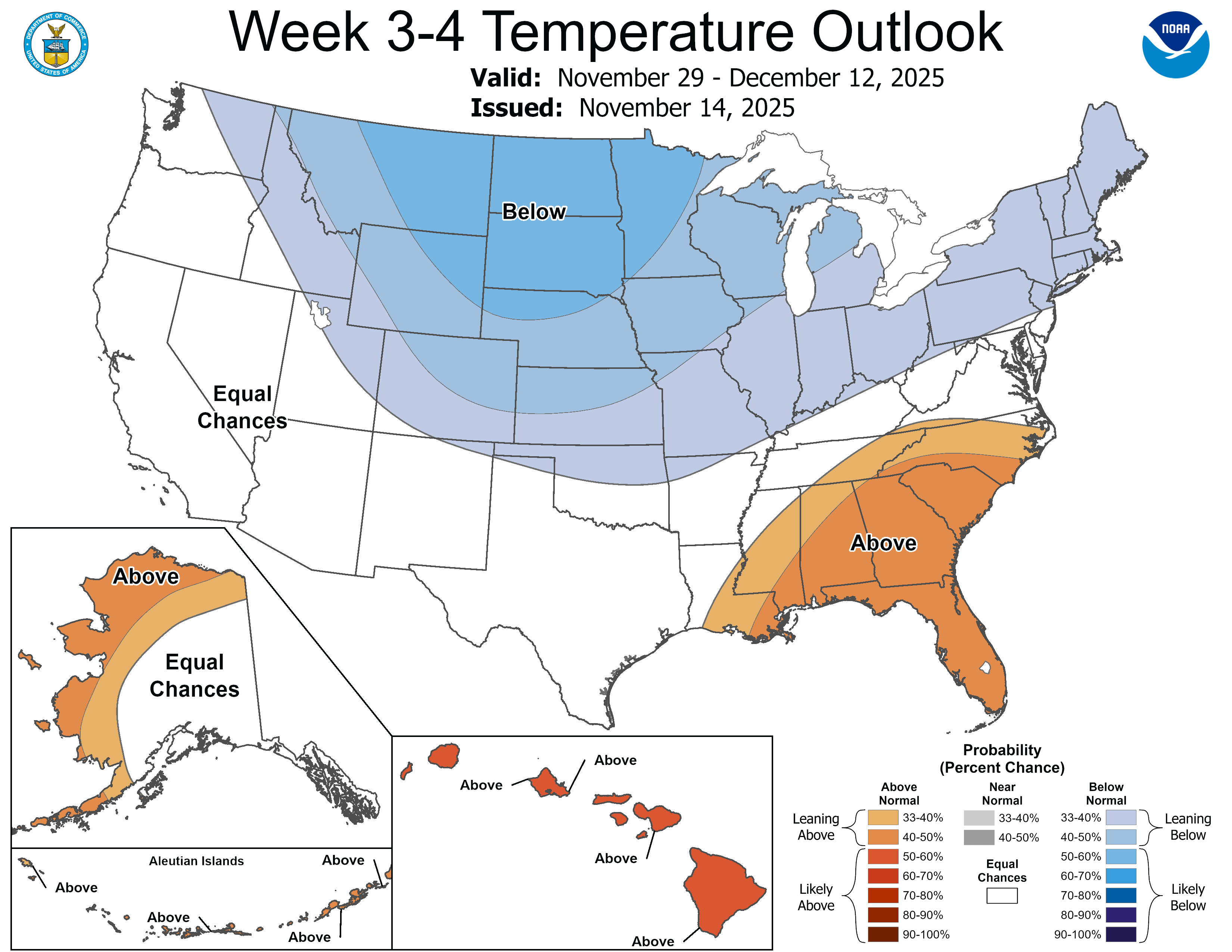
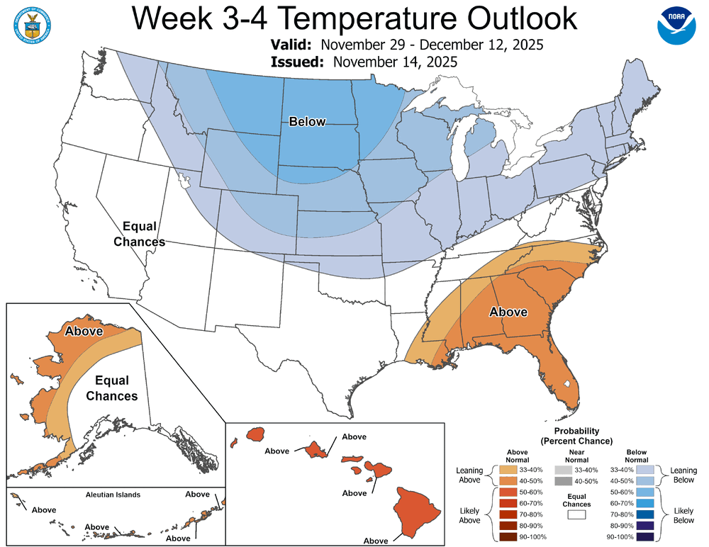
There have been some subtle shifts in the guidance. The combination of subtle shifts and long timeframes can lead to big changes. But the timeframe involved is speculative and skill scores at that timeframe are essentially non-existent. What remains extremely likely is that a sudden stratospheric warming event (SSWE) is imminent. Zonal winds will slacken dramatically during the next 5-7 days. A full reversal can't be ruled out. There is typically a lag of 10-30 days for the impact of an SSWE to propagate to the troposphere. So, even as a cold shot appears increasingly likely from the Great Lakes Region to the Northeast to close November, that cold shot will almost certainly not be the result of the imminent SSWE. What happens with the polar vortex (split and location of the pieces) will be crucial. For now, things still appear on a path toward an EPO-/WPO-/AO-/PNA- pattern development. Initially the most significant cold appears likely to dump into the Plains States before pushing eastward. The Great Lakes Region still seems primed for a possible multi-week period of below normal temperatures coupled with above normal precipitation. That should lead to an increase in snowfall totals in such cities as Chicago, Detroit, Windsor, and Toronto. Pieces of the cold should begin to bleed into the East, but perhaps after the first 7-10 days of December. If things evolve along this baseline scenario, the December 10-25 period might see the coldest anomalies relative to normal for such cities as Chicago, New York, Philadelphia. The Southeast could see some intrusions of cold, but the PNA- could promote an unwelcome and persistent tendency for SE ridging. Newer guidance suggests an increased probability of a negative NAO, so that could flatten the SE ridge at times. This is my baseline thinking. IMO, the Week 3-4 CPC Outlooks capture the temperature idea of kind of pattern I expect to prevail during the first half of December. Despite social media chatter 1983-style Arctic outbreaks, a lot would need to change for such an outbreak to become likely. Currently, the Northern Hemisphere's cold pool is much smaller than it was at this time in 1983: 2025: 1983: In the very long range, some of the subtle shifts in the teleconnections e.g., dissipation of the WPO-, could translate into the trough's migrating back to the West and a Southeast Ridge reviving in the closing week of December. That's not shown on the weekly ECMWF guidance. But the December 22-29 period's 500 mb forecasts should be monitored for hints of change. It should be noted that neither the MJO nor teleconnections can be forecast with skill at such a forecast horizon. In sum, wintry opportunities should increase in December, first in Plains States and Great Lakes and then farther East. The Great Lakes Region and Ohio Valley look primed for above normal snowfall during December. The Southeast could have the most difficult time seeing the cold try to gain traction, but some cold shots should eventually break through. The closing week of December looks uncertain. Much depends on how the SSWE's impacts will evolve and other variables that cannot be forecast with skill at that range. Typical SSWE lags would argue that the breakdown in the pattern might occur later. Then there's always the wild card of additional warming events.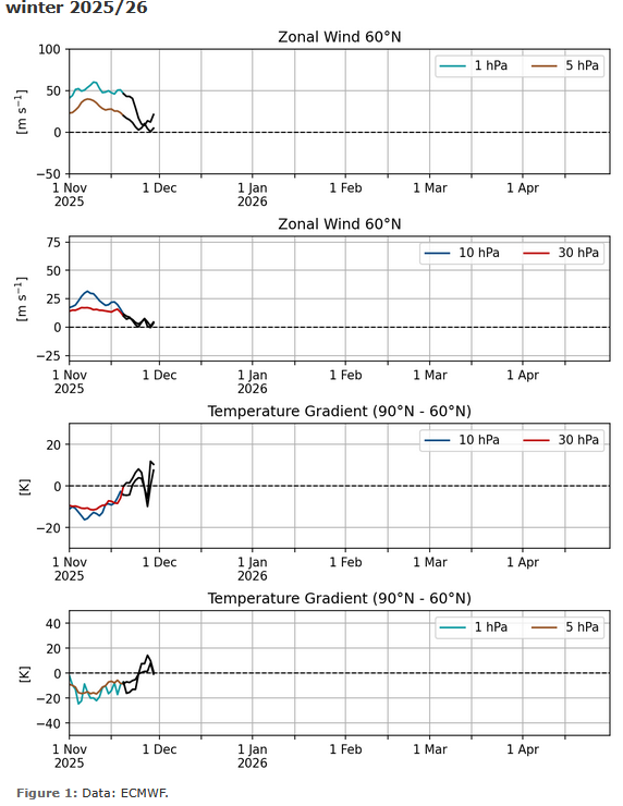
-
I’m having flashbacks of last year and the clippers that never came. .
-
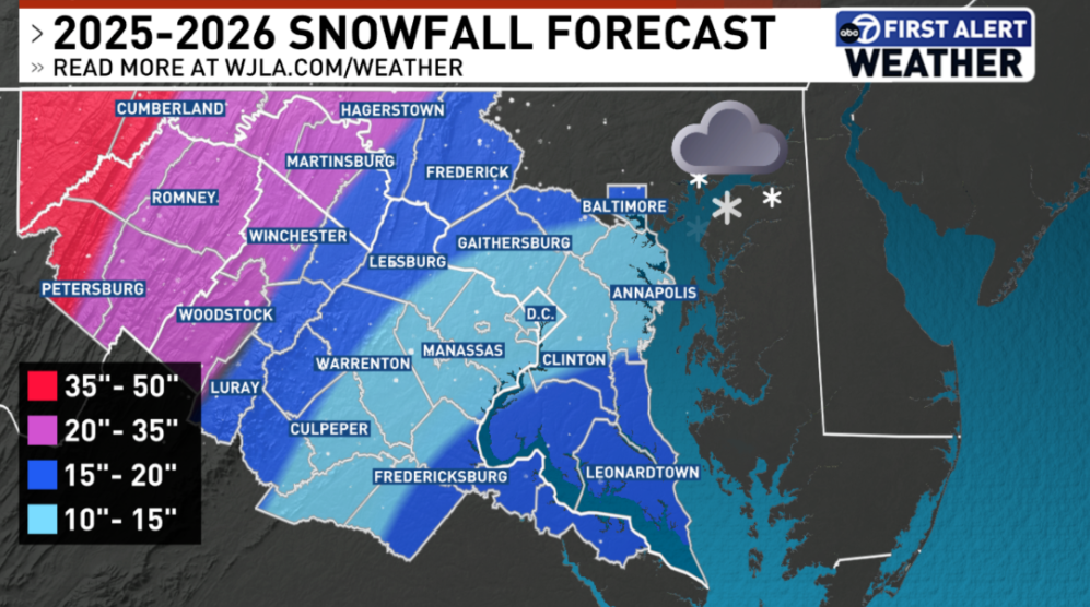
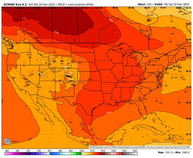
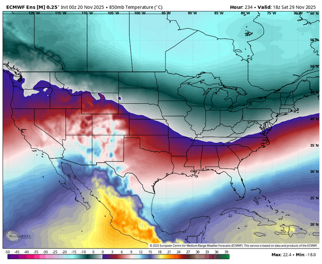
very interesting forecast because of the snowfall gradient.
-
37 / 29 and cloudy off a low of 28 here. One more day of slightly below normal and then overall above normal the next week Fri - Fri with a few days potentially much above normal (+10) Tues/Wed this week. Beyond there (29th) it looks to go overall below normal with a trough into the east and some stronger cold building northwest with a storm threat next weekend 29-30th. Nov as a whole should ed near or slightly above normal as a whole for a good portion of the area. https://cdn.star.nesdis.noaa.gov/GOES19/ABI/SECTOR/eus/02/GOES19-EUS-02-1000x1000.gif
-
Uh ?
-
I love Outdoors Maryland! I think my most “old person” coded thing is watching that show and Maryland Farm and Harvest on PBS. lol