All Activity
- Past hour
-
-

January 25/26 Jimbo Back Surgery Storm
NorthHillsWx replied to Jimbo!'s topic in Southeastern States
Probably just the 12z euro re-named “in house” -

-

January 25/26 Jimbo Back Surgery Storm
StantonParkHoya replied to Jimbo!'s topic in Southeastern States
Why aren’t you in time out . -
 Euro is warm
 -

Southern MD / Lower Eastern Shore weather discussion
AlexD1990 replied to PrinceFrederickWx's topic in Mid Atlantic
Snow maps? I can snag one from the main thread -
Copy thanks
-
 I guess it also depends how we define "fail."
 -
I dunno...but I know that's close or eh
-
I agree, was only too happy to post his excellent read in here. Look forward to Peter's continued discussions about this storm assuming he will still be "the man" for at least some of the next several days?
-
Warm mid levels? Hp weak and moving out of the way? Stronger system move NW?
-
WB AI does not have ice maps.
-

January 24-26: Miracle or Mirage JV/Banter Thread!
WxUSAF replied to SnowenOutThere's topic in Mid Atlantic
Also seems reasonable for now -

January 24-26: Miracle or Mirage Thread 2
NorthArlington101 replied to mappy's topic in Mid Atlantic
Gotta mentally get on board for the sleet storm soon. -
Reminds me of a line from the old eastern days while tracking a big storm at around 4am: "we're looking at the wrong models!"
-

-
WRAL future cast model shows the rain line not far from wake on Sunday. The wedge is not as robust at all. .
-
18z Euro op looks mighty fine i would say.
-
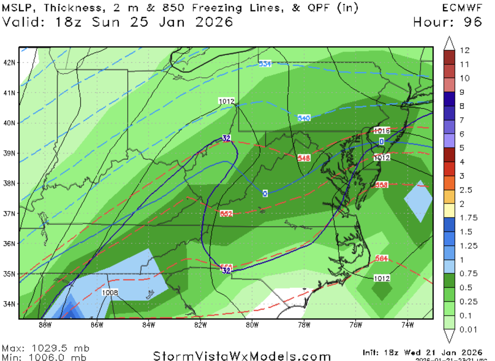
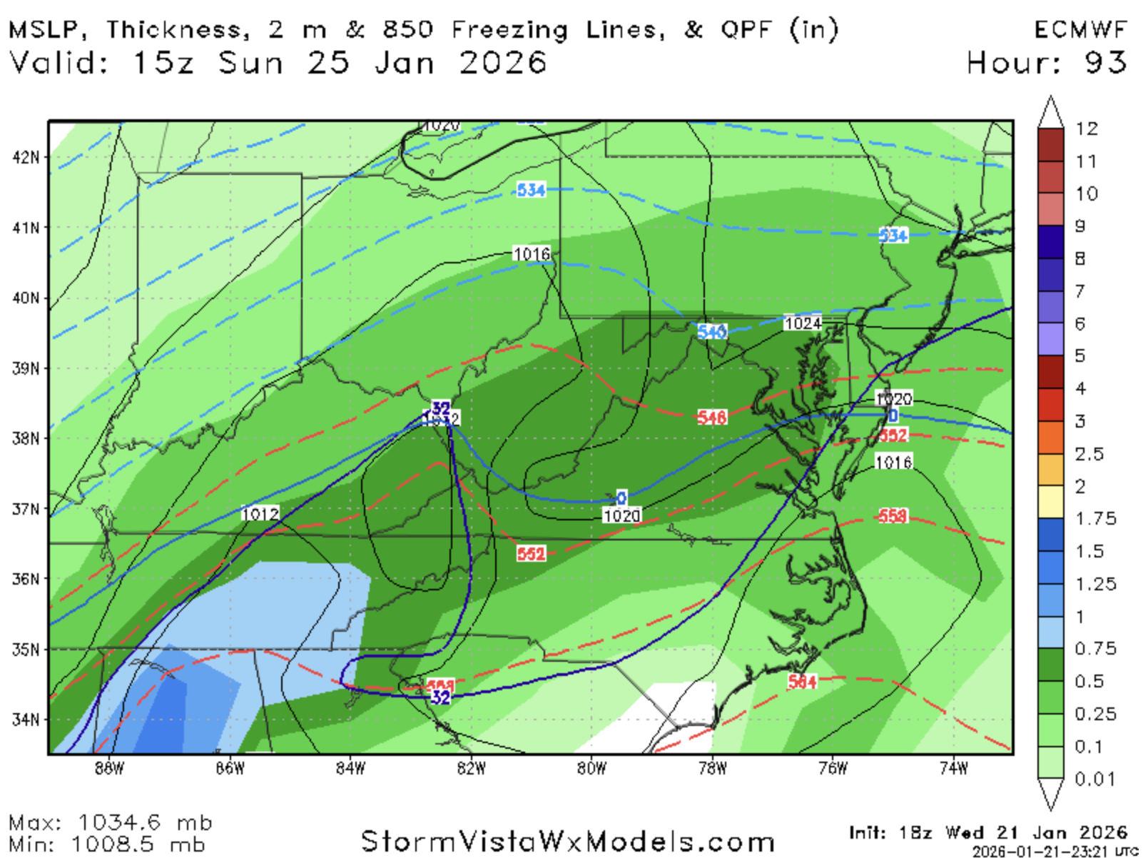
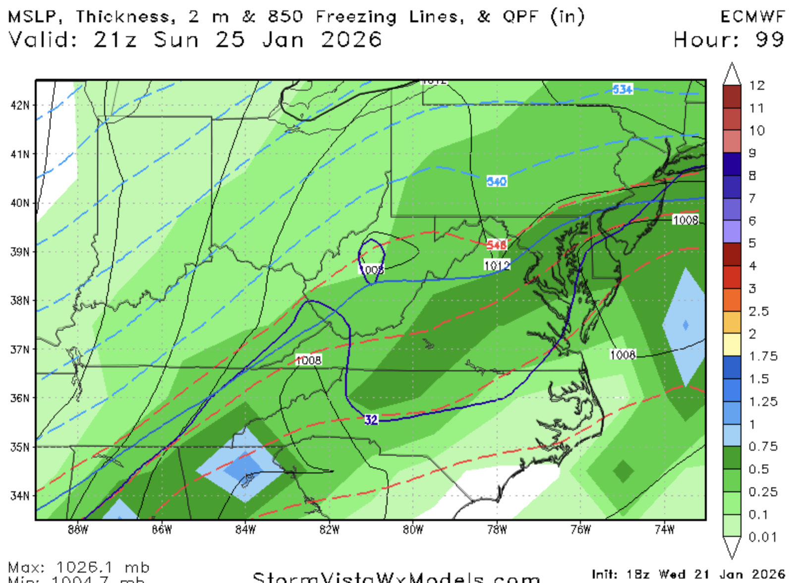
So I'm missing panels before and it jumped to 99...looks the same maybe a smidge warmer upstairs. Again...I don't have anything between 84 and 93
-

Central PA Winter 25/26 Discussion and Obs
Subliminal87 replied to MAG5035's topic in Upstate New York/Pennsylvania
I work a 24 hour shift Saturday in west Chester area and then have to drive home Sunday morning at 6am to carlise. luuuuuuucky me. -
Lots of dirty talk in there. Straight up (weather) porn
-

January 25-26 Winter Storm Potential
The Iceman replied to Ralph Wiggum's topic in Philadelphia Region
21z NBM from the MA thread -
Can you or someone post the IP and ZR map for this one? I know we shouldn't read too much in but its becoming a legit concern for the S zones. TY.
-

Possible Record Breaking Cold + Snow Sunday 1/25 - Tuesday 1/27
snowman19 replied to TriPol's topic in New York City Metro
Guess we’ll find out soon enough. I’ve seen “locked in” storms fail and I’ve seen “dead” storms come back to life in this very time frame more than a few times over the years. Just IMO the NWS doesn’t think this is locked in just yet if they are launching Hurricane Hunter recon flights and beefing up weather balloon launches to get better data sampling for the models -
Nothing really big still at 60. h5 is the smallest of ass hair flatter but sfc fields are just the tiniest of ass hair ampd