All Activity
- Past hour
-

2025-2026 ENSO
Stormchaserchuck1 replied to 40/70 Benchmark's topic in Weather Forecasting and Discussion
Yeah, I think a hotter than average July appears likely, even vs the last 10-20 years. -
18z gfs gone wild for July 4th-5th.
-
Perfectly and eloquently stated. Deep summer is locked in
-
 Historically in such a scenario the coast hits 100 early on (12-1) and then temperatures start to drop after 3 pm.
 -
Historically in such a scenario the coast hits 100 early on (12-1) and then temperatures start to drop after 3 pm.
-
did central park hit 90?
-
Cedar Rapids only made it to 93º both days this weekend, with a dew in the mid 70s, pretty standard for a moderate heat wave.
-
95 for the high currently 90/71
-
88 in Syosset & 87.8 in Muttontown for the high.
-
Clouds = heat fail today. humid but 80s and tolerable.
-
95 for a high
-
This is the earliest 80+ min on record for Chicago. Previous earliest was 6/28/1913 (min was 81 on that date).
-
temperatures now finally starting to drop at 7 pm. We hit 89 around 5 pm and hovered there for almost two hours lol
-
The heat wave is destined to break down .. obviously. That statement appears to be over selling tho. We’ll see but the thickness don’t fall below 570 behind a “weak boundary” - they’re right about that much… . Thats pretty warm and actually modestly above normal in that particular metric the whole time period averaged. There would likely be ocean modulation for eastern zones but BN may be a bit of an oversell inland in Thu/Fri. Winds also veer back s-SW by Sat and Sun. Aside from… nighttime lows will likely remain elevated if that geneal synoptic regime played out that way.
-
1233 tee time for me today. F that was hot.
-
LFG
-
Euro back to delivering quality weekends
-
That a warm , muggy 10 day. Not hot but where are the 50’s and chilly
-
Not bad! Once we get through the mild up looks like a week straight of nice sleeping weather.
-
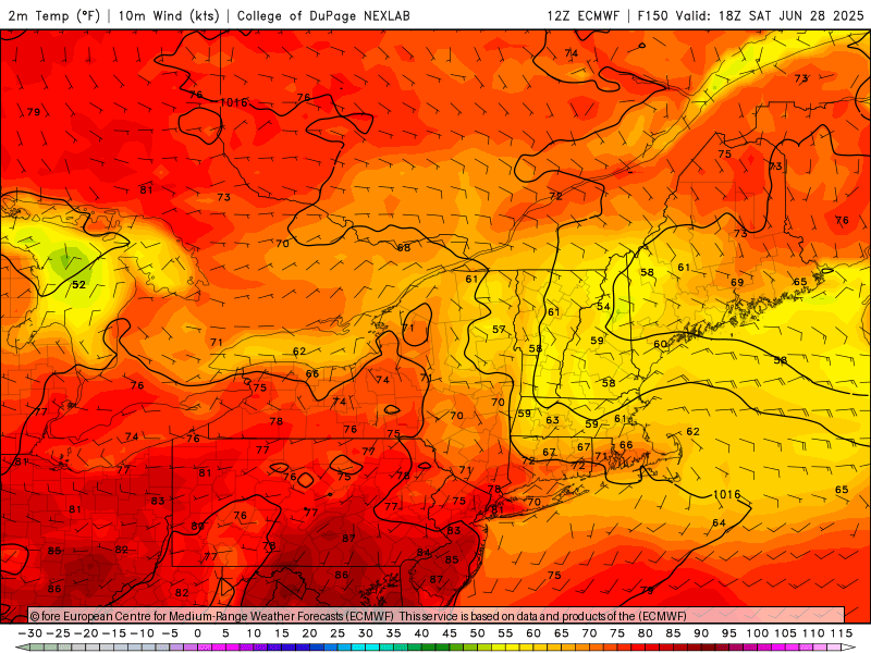
 Posted this on main June thread ... What I'm noticing about Monday and Tuesday is a very light wind field, almost NW to N as the surface flow begins to lose identity. Certainly a hot enough air mass to approach 100F in the NYC metro but will any weak sea breezes develop to keep readings in the low to mid 90s? I would bet on 102-105 in parts of NJ.
 -
I was outside way too much today. I soaked through two sets of clothes and pretty sure I lost 10lbs of water weight. Gross day but hey...productive.
-
Just checked the home station and we made it to 91 at 6:20 for probably the latest high possible
-
What I'm noticing about Monday and Tuesday is a very light wind field, almost NW to N as the surface flow begins to lose identity. Certainly a hot enough air mass to approach 100F in the NYC metro but will any weak sea breezes develop to keep readings in the low to mid 90s? I would bet on 102-105 in parts of NJ.
-
I'm hoping for a July 5, 1999 scenario (in terms of wind direction).
- Today
-
Up to 89 now, I figured I was done after hitting 88 at I don't think 90 is possible at this time but still an decent late day high especially after the rain rolled through this morning. Heat index at 98


.thumb.png.4150b06c63a21f61052e47a612bf1818.png)


