All Activity
- Past hour
-

Mid to long range discussion- 2025
WinstonSalemArlington replied to wncsnow's topic in Southeastern States
Drain those outdoor hoses -

11/8-11/10 First Snow and Lake Effect Event
Malacka11 replied to Geoboy645's topic in Lakes/Ohio Valley
I'm in westmont so pretty close to you, if not a tad west still -

11/8-11/10 First Snow and Lake Effect Event
ChiTownSnow replied to Geoboy645's topic in Lakes/Ohio Valley
Did NWS do away with 'lake effect snow warnings'. ? -
I was assuming he meant 81/82 winter.
-
Mostly cloudy (standard), but temps are outstanding.
-
11/8-11/10 First Snow and Lake Effect Event
ChiTownSnow replied to Geoboy645's topic in Lakes/Ohio Valley
I'm in Hinsdale area.. Hoping for same -

November 2025 general discussions and probable topic derailings ...
kdxken replied to Typhoon Tip's topic in New England
Good -

11/8-11/10 First Snow and Lake Effect Event
Nelson replied to Geoboy645's topic in Lakes/Ohio Valley
Good luck to everyone in the potential path - rooting for a historic event -
Had 8.3 inches of snow on the 12th, then a 2 degree low on the 13th. BUT still ended up a +5.1 for the month of Dec 1982 with the massive warmth (+15 to 20) the first week of the month and the few days after Christmas running +15's.
-
11/8-11/10 First Snow and Lake Effect Event
Nelson replied to Geoboy645's topic in Lakes/Ohio Valley
This is wild As a result, the expectation is for the lake effect snow bands to be unusually intense with peak snow rates of 3 to locally 5 inches per hour, frequent lightning and thunder, and pockets of hail. -
11/8-11/10 First Snow and Lake Effect Event
Malacka11 replied to Geoboy645's topic in Lakes/Ohio Valley
Moved east almost to the border of cook and dupage. Obv still not near ground zero but it would be cool to get in on something. Maybe if round 1 does okay this far inland and then the band drifting down from the WI border also makes it to us for a bit, we could get the ground full white for the afternoon. Congrats Alek/downtown gang, mclovin it for you -
.thumb.png.4150b06c63a21f61052e47a612bf1818.png)
November 2025 general discussions and probable topic derailings ...
HIPPYVALLEY replied to Typhoon Tip's topic in New England
Weeks of boredom incoming. Also doesn’t look like a ton of moisture for the drought areas. -

11/8-11/10 First Snow and Lake Effect Event
ILSNOW replied to Geoboy645's topic in Lakes/Ohio Valley
Currently no watches or warning in Wisconsin!! -

11/8-11/10 First Snow and Lake Effect Event
sbnwx85 replied to Geoboy645's topic in Lakes/Ohio Valley

-
And sadly the plane and train crashes.
-

11/8-11/10 First Snow and Lake Effect Event
A-L-E-K replied to Geoboy645's topic in Lakes/Ohio Valley
Good sign -

11/8-11/10 First Snow and Lake Effect Event
mimillman replied to Geoboy645's topic in Lakes/Ohio Valley
-
1982 is highly underrated. Those consecutive cold Sundays were bitter cold and record setters!
-
It’s not scientific but it is reality for DC/ -15 departures are hard to come by and it’s a waste at this time in Nov. if it’s the beginning of a near constant 30-45 day reload pattern then that’s different but usually not the case The main thing we need turned around us the absence of Miller As. second and in conjunction are clippers cutting under us pulling down reinforcing cold air . whatever causes those two is what I want to see in projections mjo and SSW stuff to me is unproven. The two circumstances referenced above are proven
-
Had a gusty shower around 10:30 am, and another one around 1:30 pm. High (I'm assuming since it has dropped a few degrees) was 61.6 degrees around 1 pm. Currently 59.2/48.7 at 2:15 pm with mostly cloudy skies.
-

11/8-11/10 First Snow and Lake Effect Event
homedis replied to Geoboy645's topic in Lakes/Ohio Valley
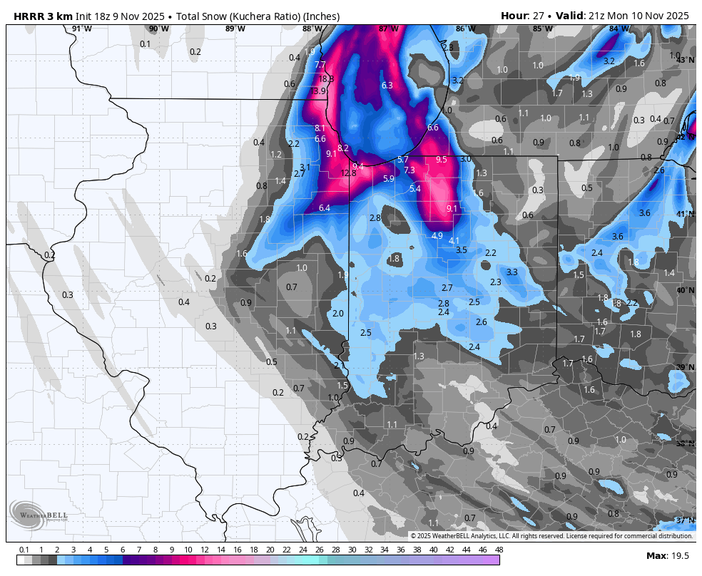
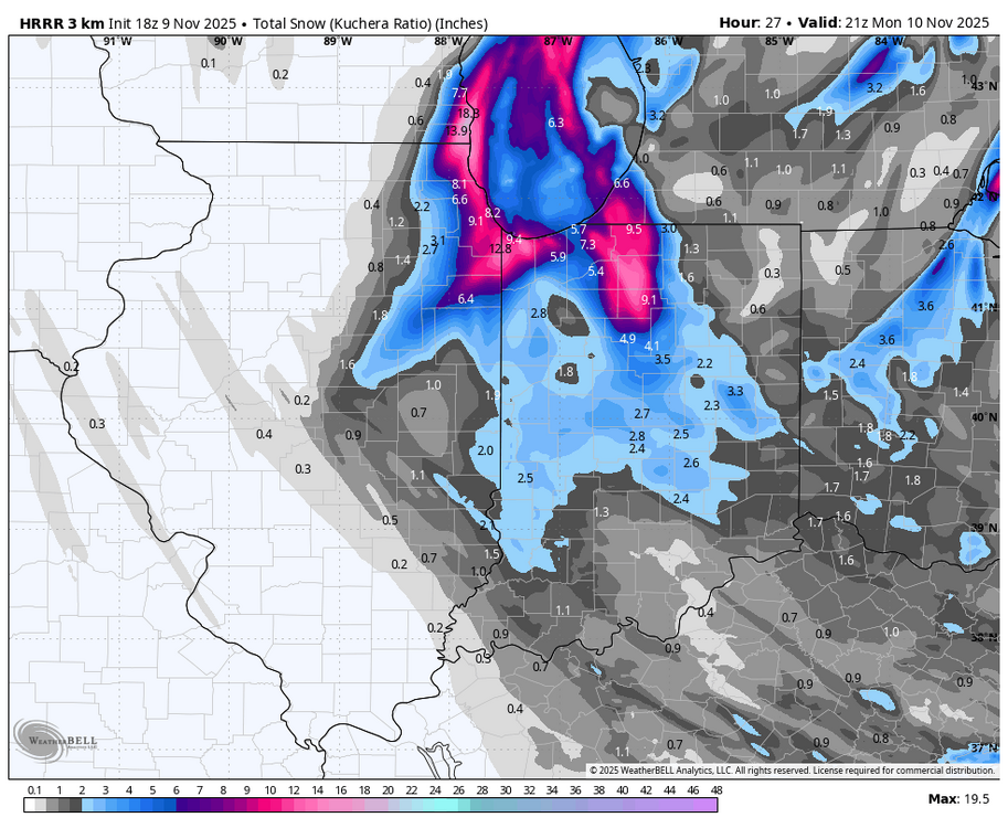
HRRR is liking Lake Co., IL & Kenosha a little more with the 18z. -

2025-2026 Fall/Winter Mountain Thread
Buckethead replied to Buckethead's topic in Southeastern States
KMRX has upgraded the WWA's to a WSW just over the border. Sent from my SM-S908U using Tapatalk -

11/8-11/10 First Snow and Lake Effect Event
weathafella replied to Geoboy645's topic in Lakes/Ohio Valley
Nice to see snow in the air at the giants/bears game. My daughter works downtown and lives in Logan Square. I bet she’ll have a lot more at work near the lake vs home. Meso effects are so unpredictable. I was visiting in July and we went to dinner in the west Loop area one night and got 3” of rain in a fairly short time. 5 miles north nothing. -
Made that post yesterday basically saying I wish this setup happened about a month later .
-
I'd love to have a new storm track one of the years. The one of the last decade sucks...not even "higher amounts north and west of the city" exists anymore! I find the fact that there is no clear cause rather annoying, lol