All Activity
- Past hour
-
Start time guesstimate anyone ? 8 am ?????? and when does she get cranking is it in the afternoon or at night ?
-
06z :
-

Southern MD / Lower Eastern Shore weather discussion
SnowtoRain replied to PrinceFrederickWx's topic in Mid Atlantic
Would have been nice if guidance converged, I still like my earlier post of Greenwood, DE to the Atlantic Coast. I have a hard time believing the GFS. -

February 22-23 Storm Thread/OBS
MickeyTim6533 replied to Mikeymac5306's topic in Philadelphia Region
Why does it seem all the major mets hug the EURO?? -
I don’t know. Think we’re in a good spot to catch some ML goodies as it stands.
-

“Cory’s in NYC! Let’s HECS!” Feb. 22-24 Disco
Kitz Craver replied to TheSnowman's topic in New England
Monday morning is the height of the storm. Could be near impassable roads. Wouldn’t be surprised if they issue a state of emergency and keep nonessential workers home -
Everyone will be rating this an A+ winter in 48 hours
-

“Cory’s in NYC! Let’s HECS!” Feb. 22-24 Disco
Damage In Tolland replied to TheSnowman's topic in New England
And this coming Wednesday
-
Didn't see it posted, but 6z Eps improved over 0z.
-

“Cory’s in NYC! Let’s HECS!” Feb. 22-24 Disco
RUNNAWAYICEBERG replied to TheSnowman's topic in New England
Would be. I think the later capture is still being ironed out and if keeps ticking NE today, that should help distribute precip more north. . -

“Cory’s in NYC! Let’s HECS!” Feb. 22-24 Disco
Cyclone-68 replied to TheSnowman's topic in New England
I wonder if this storm develops an eye like feature like the real biggies did -
Mt Holly covered its bases well here. 8-16 forecast, takes care of the Euro's lower tier and touch bases of GFS/NAM.
-
I just need 7” more to hit 40” on the year.
-

“Cory’s in NYC! Let’s HECS!” Feb. 22-24 Disco
CTWeatherFreak replied to TheSnowman's topic in New England
What are ratios looking like with this one? Do the strong winds lead to mangled flakes and lower ratios? -
February 22-23 Storm Thread/OBS
MickeyTim6533 replied to Mikeymac5306's topic in Philadelphia Region
yeah, seems like the cut backs are beginning -
“Cory’s in NYC! Let’s HECS!” Feb. 22-24 Disco
Damage In Tolland replied to TheSnowman's topic in New England
In case anyone was wondering here’s next weekend
-

“Cory’s in NYC! Let’s HECS!” Feb. 22-24 Disco
weatherwiz replied to TheSnowman's topic in New England
Going to be a fun day of model analyzing Probably put together a map/discussion after 12z. -
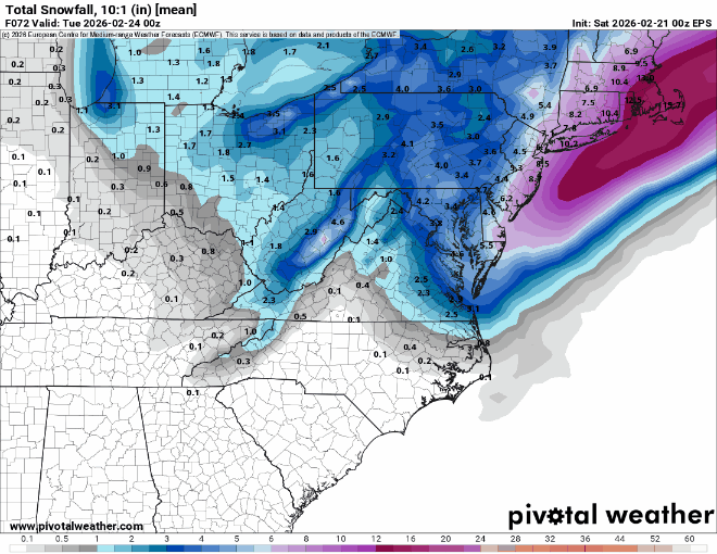
2/21 06z Summary Total QPF NYC / Total 10:1 Snow NYC SREF: 1.8 / 16.9 NAM: 2.3 / 22.5 RGEM: 1.5 / 14.7 ICON: 1.4 / 12.9 GFS: 2.3 / 22 GFS AI AIFS: 1.6 / 15.8 UKMET: 1.0 / 10.4 GEFS: 1.8 / 18.4 EURO: .09 / 10.1 EURO AI AIFS: 1.1 / 11.1
-
6.5”
-
Euro is still playing catch - up I think the NWS is ignoring it now - but some private METS which will remain nameless are still considering it
-
Agree. I’m skeptical but only because of how notorious the Miller B types are around here. A west shift would help. Banter-y; my sister is sitting comfortably under a blizzard warning in NJ. Meh.
-

“Cory’s in NYC! Let’s HECS!” Feb. 22-24 Disco
HoarfrostHubb replied to TheSnowman's topic in New England
I agree with Ray on that. They could issue a SOE here in Mass. but it is pretty meaningless. They just want folks off the road. -
In a different thread.
-
When this one is over.
-
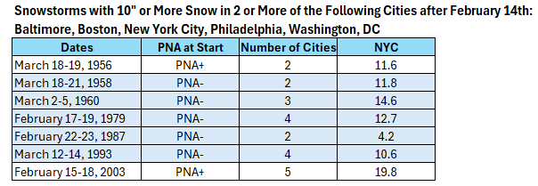
On February 20, 2026, the PNA was -1.475. The PNA is forecast to remain negative through the remainder of February. During the second half of February and afterward, most of the big I-95 Area snowstorms occur with a negative PNA on account of shortening wave lengths. A major to potentially historic blizzard is possible Sunday into Monday. With 10.0" or more snow, Winter 2025-2026 would be on track to become just the third winter on record in New York City to record two 10" or greater snowstorms, a seasonal mean temperature of 32.0° or below and 30.0" or more seasonal snowfall. Winter records go way back to 1869-1870.