All Activity
- Past hour
-

Winter 2025-26 Medium/Long Range Discussion
Baum replied to michsnowfreak's topic in Lakes/Ohio Valley
The northeast and mid Atlantic are nearing some of the lengthiest snow packs in decades with near records in some cases. And most of it stemmed from an event 2-3 weeks ago. Was not aware climatologicaly how much easier it is for our area to retain snow cover versus them. Here, a 2-3 week cover from a 10” event in mid winter is standard. Heck, this pack were melting off is basically from a duster train and lake effect event. I figured it’d go poof. Not so. But another day of 50’s will end it. Bring on a salt washer. Of course we’ll probably follow that with an 8” tree snapper. -
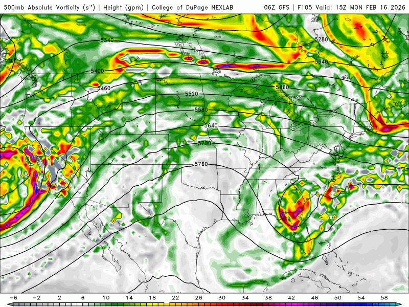
Definitely a trend to speed up that southern stream though allowing that northern stream to dig and partially phase.
-
The storm that will devastate the Sierra with high winds and brobdingnagian amounts of snow Sunday night thru Thursday next week, ORIGINATES FROM ALASKA. It will be a frigid storm laden to the gills with enormous amounts of Pacific moisture. It will smash into all the California mountains and be forced violently upward condensing into ridiculous quantities of torrential snow that will simply pile up, feet and feet maybe meters. High winds will pile up drifts and cornices at ridges that will result in severe avalanche dangers. In short, this is not the weekend to go skiing along the Sierras. Travel will be impossible. This storm is so cold that it will snow on the valley floors. Every mountain in California including the coastal ranges will be utterly demolished with snow. New records will be set. Models are depicting up to 7 inches of pure water. Snow to water ratios will increase to 14 to 1. This is going to be BAD. THIS STORM WILL TAKE NO PRISONERS. This storm is only the first in a classic Pacific Set.
-

E PA/NJ/DE Winter 2025-26 Obs/Discussion
Duca892 replied to LVblizzard's topic in Philadelphia Region
Looks pretty ok for a light 1-3in snowfall for the Lehigh Valley with 2-4in around Bucks/Phillg areas -
-
Not gonna be happy if I end up with clouds out of this Monday
-

Is we back? February discussion thread
Damage In Tolland replied to mahk_webstah's topic in New England
Seemed like one bad run at 00z . With that cold high up there and - NAO. Cold should be the thinking -
I'll take the 984mb low over the cape
-
This was my thinking as well. Bummer .
-
9z SREFS have a few fun members Well north of 3z
-
The bigger picture has been how we can’t get much precipitation of any P-type with the expanding drought across the U.S heading into the warm season. We had the one major system in late January with very high snow ratios before the mixing began. Even the clippers in December started out higher ratio before the mixing and dry slot arrived.
-
It's certainly possible we may not get much of anything out of this one but chances for something is at least better than 24 hours ago.
-
06z runs did look a bit colder again for late week. It’s like 00z all saw something to go warmer and then ticked it back a bit at 06z. Still need to wait and see on that.
-
Recent trend is not our friend. Let’s see if 12z can flip it back
-
Is we back? February discussion thread
Damage In Tolland replied to mahk_webstah's topic in New England
Maybe this is our icestorm? -
Is we back? February discussion thread
Damage In Tolland replied to mahk_webstah's topic in New England
Wet ? Nah it’s been talked about as snowy period on all ensembles etc. A rainy week seems unlikely -
We don’t get tingly about rain however
-
It may be one of those deals that has a band well north even if what’s modeled
-
Skied at Sugarbush on Thursday. It was very good. At Killington yesterday and found similar conditions. Stuck to groomers but peeking into woods coverage looked excellent. On the lifts, met multiple people from Midwest who had pivoted from western resorts to the east because of the lack of snow in the west. It should be a big week with vacations.
-
Why do we always end up back at the shit gfs showing the solution we want the most? there’s been good trends north on many models, but gfs is coldest at the surface
-
That's because they're all tingly about useless overnight trends
-
Is the GRAF model still showing a blizzard?
-
And a huge change with the west coast storm.
-
Everything should be onshore and better sampled at 12z..
-
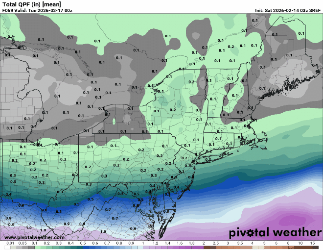
We will be lucky to see more than an inch out of this. The trough is severely positively tilted, goes negative way too late because the phase is way late and occurs as it’s moving away over the open Atlantic and the flow is extremely fast, this thing is going to have the jets on. But this is my last comment on it, don’t want to get accused of trying to take your snow away. Btw, the new EURO AIFS just dropped accumulations again and the CMC/RGEM/GEPS want nothing to do with it. Best of luck tomorrow night


