All Activity
- Past hour
-

NEW DISTURBANCE: Central Tropical Atlantic (0/40)
WxWatcher007 replied to BarryStantonGBP's topic in Tropical Headquarters
I just want to take a second to illustrate what I mean. The signal is robust on both sets of ensembles, though it is stronger on the GEFS. Now looking beyond ensembles, I think development is likely for a few reasons, even if delayed. First, the preceding wave and Erin have helped reduce SAL significantly. While there is still plenty out there which may inhibit development, I don't know if dry air/SAL alone will kill the wave, especially with another CCKW likely assisting in future. There are pockets of shear that could cause trouble, but the ensembles don't show an overwhelmingly prohibitive signal as this gets closer to the Antilles. Currently, the wave is in a narrow corridor of lower deep layer shear. I'm not sure it's all systems go, but I think the operational models aren't quite picking up on TC genesis potential quite yet. -
.19 . take it I guess
-
That’s what he said
-
Quick little storm.... Definitely had a bit of wind ... 0.26 0.28 monthly total now...
-

Hurricane Erin: 125 MPH - 946mb - WNW @ 13
Chinook replied to BarryStantonGBP's topic in Tropical Headquarters
Does Levi from Tropical Tidbits even care about Youtube anymore? -

Hurricane Erin: 125 MPH - 946mb - WNW @ 13
wthrmn654 replied to BarryStantonGBP's topic in Tropical Headquarters
Didn't realize the nhc was using Google products This track lies roughly in between the Google Deep Mind ensemble mean (GDMI) and HFIP corrected consensus approach (HCCA). -
Hurricane Erin: 125 MPH - 946mb - WNW @ 13
wthrmn654 replied to BarryStantonGBP's topic in Tropical Headquarters
00z models run and again the nhc track is to far east jeez. -
I crushed you with my .03
- Today
-
Ocracoke Island now has mandatory evacs effective immediately. (If this should be in OBS please move. Not an active discussion other than here)
-
There is a lot more support for the cooler solution in the evening guidance, including from the always-mixed and warm HRRR and HiResW FV3. There is also growing consensus that much of the area might not get out of the 60s.
-
You beat me by 0.026"
-
I'm the leader now. .12 in that shower. A tropical .48 for the month so far.
-
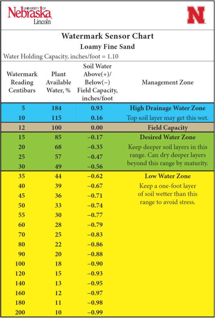
Steiner Bros racking up the rain tonight while I enjoy my 0.00” Soil moisture has been around 80cb. That’s about as dry as I’ve seen it here.

-

E PA/NJ/DE Summer 2025 Obs/Discussion
PhiEaglesfan712 replied to Hurricane Agnes's topic in Philadelphia Region
You finally admitted that there is no drought! My area hasn't been in a drought since about March 5. -

E PA/NJ/DE Summer 2025 Obs/Discussion
Kevin Reilly replied to Hurricane Agnes's topic in Philadelphia Region
Today's high 94f after a low of 70f Sunny all day. Rainfall today Total: Trace a few drops at 9:20 pm lightning east. Currently 78f humidity 86% dewpoint 74f -
.35 here. Good storm.
-
He trained. As usual asleep during heavy stuff. I see 1.77. Probably a little more when all is said and done.
-
 All missed here. Philly area getting hammered
 -
The radar loop over him did look longer... it's always that trailing core that pushes amounts up when a line is pushing through. Your area got hit with those higher DBZ (dark red, ha) echoes on radarscope too, that are indicative of just torrential rain. I always enjoy how rainfall rates in that super humid air tends to follow almost exponential increases as the pixel DBZ increase.
-
aren't we due for a blizzard? it's been nine years since the last one.
-
I noticed. That sucks. Been happening here a lot recently. Finally got a direct hit.
-

E PA/NJ/DE Summer 2025 Obs/Discussion
Birds~69 replied to Hurricane Agnes's topic in Philadelphia Region
Tapering off here. I can hear the street sewers trying to play catch up. No clue but thinking 1"+... .. -
Completely fell apart as it came through Easton, 0.07", going to get real crispy down this way
-
1.2" Bull's eye. Been forever.
-
He’s got like 1.5” lol. .9” here.