All Activity
- Past hour
-

July 2025 Discussion-OBS - seasonable summer variability
LibertyBell replied to wdrag's topic in New York City Metro
This is probably a good thing for the growing season to be longer? I remember August 1986 that was my first Perseid meteor shower and it was a crystal clear sky with no haze temperatures near 50, felt like early fall. That first time had the best viewing conditions of any time I've seen it since (outside of the times I've seen them in the Poconos away from light pollution.) -
The solution is to just have a yard made of weeds like me: only 3.30" MTD and still looking good!
-
 My PWS is seeing rates over 4 inches per hour on the north shore. Ground is hard and bone dry so I wonder how that’ll go. I’m near ISP right now where it’s dry but looks 8 PM.
 -
 Yea the part that pulled away was in NE Queens. It looks like a tail is holding on in southern Flushing/Briarwood.
 -
Some backbuilding/training of those MoCo cells. Area from around Great Falls to Kensington and Sligo Creek areas are in trouble if this keeps up. Really bad spot to have training storms.
-
Looks like some flooding occurring just east of Potomac
-
 Looks like it's back building towards Flushing on my radarscope app.
 -
1.50" so far.
-
I know how they're going to play out. Tamaqua and eastern Schuylkill County will be fringed, as usual.
-
I just went through it and the drops were the size of silver dollars. But it's finally pulling away slowly.
-
 Very close. last August did not fringe my location. 9" in 3 hours.
 -
Flood Advisory National Weather Service New York NY 157 PM EDT Thu Jul 31 2025 NYC103-311930- /O.NEW.KOKX.FA.Y.0056.250731T1757Z-250731T1930Z/ /00000.N.ER.000000T0000Z.000000T0000Z.000000T0000Z.OO/ Suffolk NY- 157 PM EDT Thu Jul 31 2025 ...FLOOD ADVISORY IN EFFECT UNTIL 330 PM EDT THIS AFTERNOON... * WHAT...Flooding caused by excessive rainfall is expected. * WHERE...A portion of southeast New York, including the following county, Suffolk. * WHEN...Until 330 PM EDT. * IMPACTS...Minor flooding in low-lying and poor drainage areas. * ADDITIONAL DETAILS... - At 156 PM EDT, Doppler radar indicated heavy rain due to thunderstorms. Minor flooding is ongoing or expected to begin shortly in the advisory area. Between 1 and 1.5 inches of rain have fallen. - Additional rainfall amounts of 1 to possibly 2 inches are expected over the area. This additional rain will result in minor flooding. - Some locations that will experience flooding include... Centereach, Hauppauge, Stony Brook, Port Jefferson, Coram, Smithtown, Mount Sinai, Lake Ronkonkoma, Selden, Kings Park, Setauket, Nesconset, St. James, Miller Place, Lake Grove, Port Jefferson Station, Nissequogue, Head Of The Harbor, Poquott and Belle Terre. - http://www.weather.gov/safety/flood PRECAUTIONARY/PREPAREDNESS ACTIONS... Turn around, don`t drown when encountering flooded roads. Most flood deaths occur in vehicles.
-
NE Queens and NW Nassau are probably going to get flood warnings in 20 or so minutes. It's pouring in Great Neck and the line isn't moving at all.
-
 Same exact places as last August. Rt 347 area getting slammed.
 -
Closing out the month here in Greenville, NC with the most hideous dew point I've ever seen:

-
 Breezes picked up. Getting dark to my west now too. That system slowly creeping ne getting scary looking.
 -
 I've been getting some 30 to 35mph gusts. Not too bad.
 -
Downburst/microburst signal on the Montgomery County cell it looks like.
-

July 2025 Obs/Disco ... possible historic month for heat
klw replied to Typhoon Tip's topic in New England
Who looks ridiculous now! -

E PA/NJ/DE Summer 2025 Obs/Discussion
RedSky replied to Hurricane Agnes's topic in Philadelphia Region
.30" -

July 2025 Discussion-OBS - seasonable summer variability
bluewave replied to wdrag's topic in New York City Metro
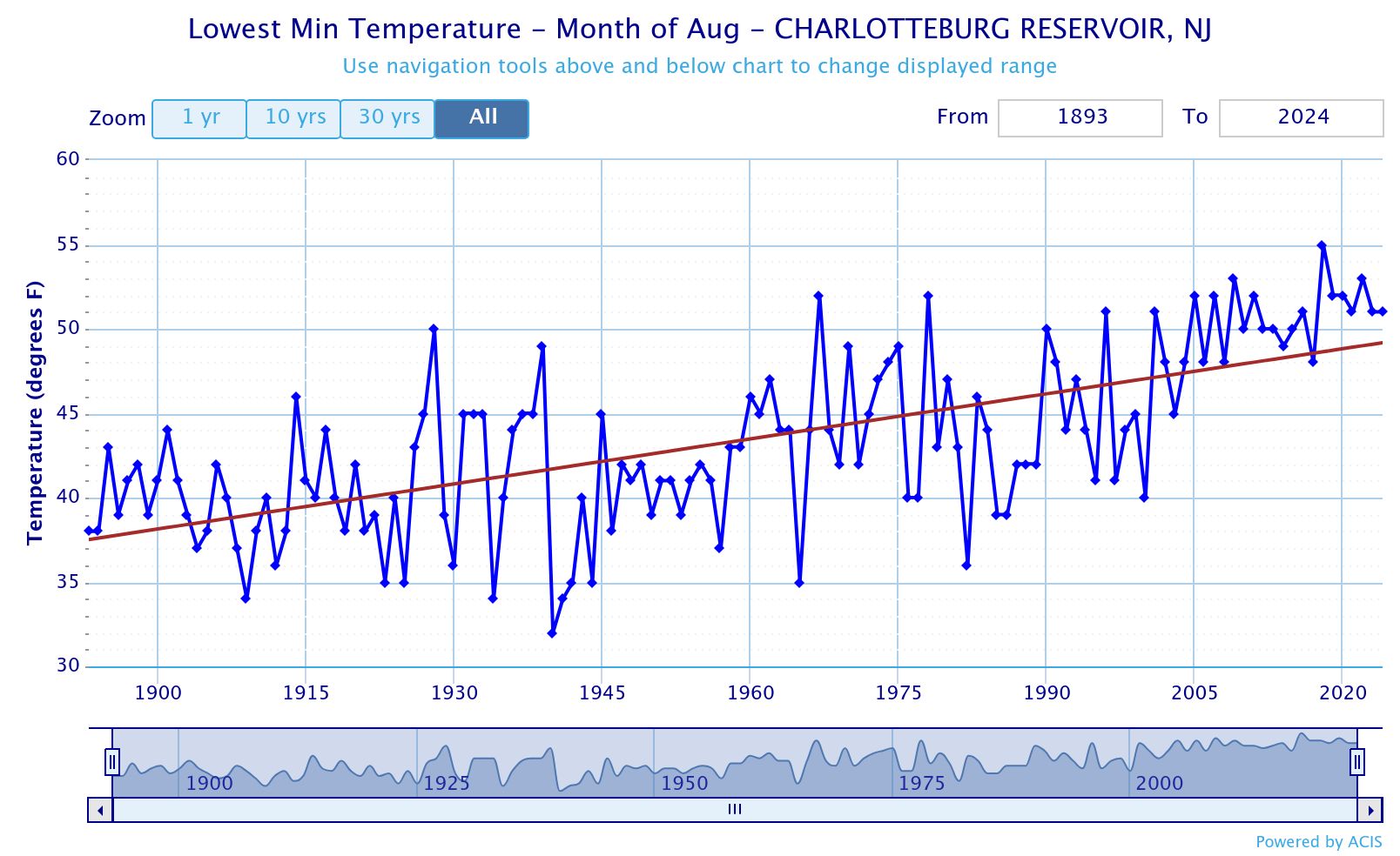
Dipping into the upper 30s periodically back then in July probably wasn’t that much of an issue for the growing season. But August lowest temperatures in the 30s at the Charolotteburg Reservior were a much more common occurrence. They haven’t dropped below 50° in August since 2017. Their last 30s in August was in 1986. Their earliest first freeze was on 8-25-40. 9-7-84 was their last freeze during the first week of September. So rural NJ used to have a much shorter growing season than it has now. The average first freeze was September 26th from 1895 to 1910. From 2010 to 2024 the average first freeze is on October 22nd.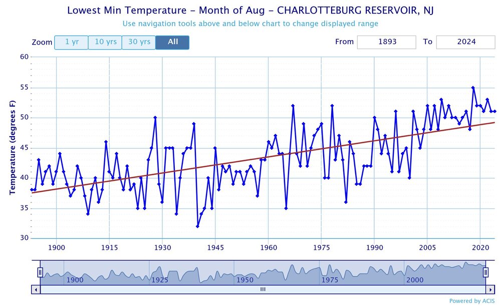
-
 Definitely not state of emergency level since storms are localized, but some areas that got hit hard on July 14th are getting walloped again with slow moving storms.
 -
0.33” from a scraper earlier
-

July 2025 Discussion-OBS - seasonable summer variability
TheClimateChanger replied to wdrag's topic in New York City Metro
This is an interesting map. Number of 90+ days since June 1. All the long-term climate stations along the I-95 are in the top 10, except for NYC, which is tied for 44th. Things that make you go hmmm...