All Activity
- Past hour
-
cool trend
-
One of the best football games you’ll ever watch. Playoff this year has produced
-

January 2026 regional war/obs/disco thread
HoarfrostHubb replied to Baroclinic Zone's topic in New England
Our daughter’s view at work today. Rode the snowmobile to the summit. Operating the top shack of their brand new 6 pack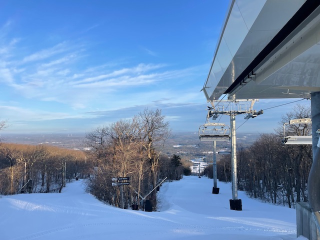
-
Is that for all major reporting stations or just ISP, which was the warmest of all stations last month? Every major was around -5 to -6 for the month, ISP was only -2.8.
-
January 2026 regional war/obs/disco thread
HoarfrostHubb replied to Baroclinic Zone's topic in New England
Good luck with that. HRRR has been a pile of poop lately -

January 2026 regional war/obs/disco thread
jbenedet replied to Baroclinic Zone's topic in New England
I’m just talking widespread warning level snow. Thats what my odds are against. … -
OOOOF. I followed that line and imagined a few shattered TV screens last night when they covered every player except Beck. I’ve been taking so many Ls lately that I’ve started not loading any more money onto my FanDuel account
-

January 2026 regional war/obs/disco thread
ineedsnow replied to Baroclinic Zone's topic in New England
still going after hr 48.. it would be nice to get a couple inch refresher -
I like this trend on the Euro
-
January 2026 regional war/obs/disco thread
ineedsnow replied to Baroclinic Zone's topic in New England
12z HRRR has a bit of snow here Saturday night.thumb.png.1306f53dd4651d1dbeab434dd4f498de.png)
-

January 2026 regional war/obs/disco thread
CoastalWx replied to Baroclinic Zone's topic in New England
Also I think most people aren’t suggesting a big dog at the moment. -
this is the most accurate thing ever lol but 95% of people here have no idea what sybau means lol
-
January 2026 regional war/obs/disco thread
CoastalWx replied to Baroclinic Zone's topic in New England
I see what you mean on the euro AI. But just 12 hrs ago that was a fropa on that model. -
January 2026 regional war/obs/disco thread
jbenedet replied to Baroclinic Zone's topic in New England
predictions made with present data. Not making predictions based on the data changing…no evidence for that. Always the case. But looking at the large scale features and the agreement on them across important guidance at this stage…. It’s very low odds of a big snowstorm. My take. -
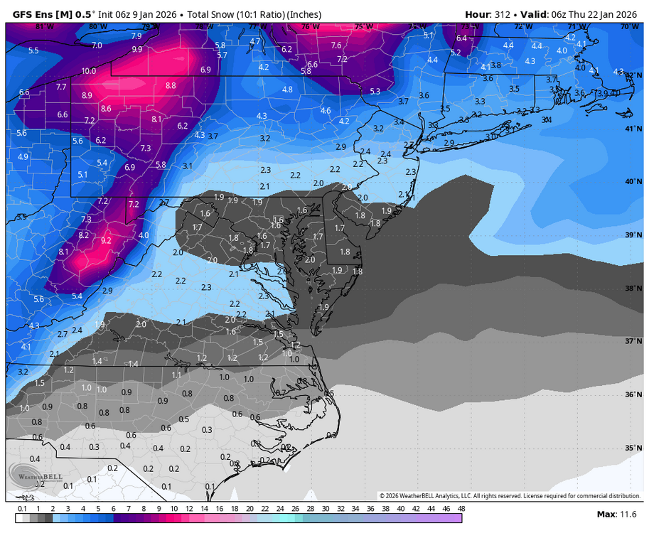
I’m down to shaded areas only with snow cover; but hopefully about to load up in the next week to 10.
-

NNE Cold Season Thread 2025-2026
backedgeapproaching replied to Boston Bulldog's topic in New England
Yea, I was talking more "backyard" snow depth optics. I went from 8-10" down here to T (about 30% coverage). Most dropped down to 1-4" like you mentioned, and even though those remaining 1-4" were totally waterlogged with pretty high LE, that is still a big hit and pretty much starting over regardless of LE. (again just "backyard" base) Now, obviously a different story on the ski hills, where all it really did was add SWE to build the base moving forward--even if there was a little snow depth decrease. -
Dont forget after those fails I chime in and state how much I loathe this hobby. Ji then cancels winter for the 22nd time, Weather53 says see I told you we are kicking the can again, mitch tells us he had a hunch January was toast, Terpeast says he has concerns for Feb being we are in a Nina but there is hope, Randy calls us nuts and tells Chuck to sybau, aldi22 says we are dumb, Maestrobjwa tells us hes learning new stuff every day, winter warlock replies to each post with 'lol' or 'lmao', then PSU posts a 3 page diatribe on how he hopes this isnt the new norm. Yeah, I think thats the usual pattern iirc.
-
I am not saying GEFS is right...hopefully we will be tracking a threat by the end of this weekend.
-
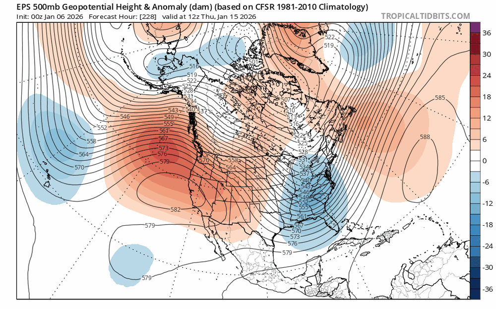
From a WPC met:
-
Yup! WB 6Z GEFS through Day 13 says it all:
-
Colder start to winter than recent years but not as cold as 17-18 was through January 8th. Time Series Summary for ISLIP-LI MACARTHUR AP, NY December 1st through January 8th Click column heading to sort ascending, click again to sort descending. 2026-01-08 34.1 0 2025-01-08 35.8 0 2024-01-08 40.7 0 2023-01-08 38.6 0 2022-01-08 40.3 0 2021-01-08 36.9 0 2020-01-08 37.3 0 2019-01-08 38.2 0 2018-01-08 30.3 0
-
More west/southern digging…trends I’m rooting for!
-

January 2026 regional war/obs/disco thread
WinterWolf replied to Baroclinic Zone's topic in New England
Pope, Also have to understand/take into consideration, what you’re seeing currently, may not be what actually may be happening 3-5 days from today. -
(002).thumb.png.6e3d9d46bca5fe41aab7a74871dd8af8.png)
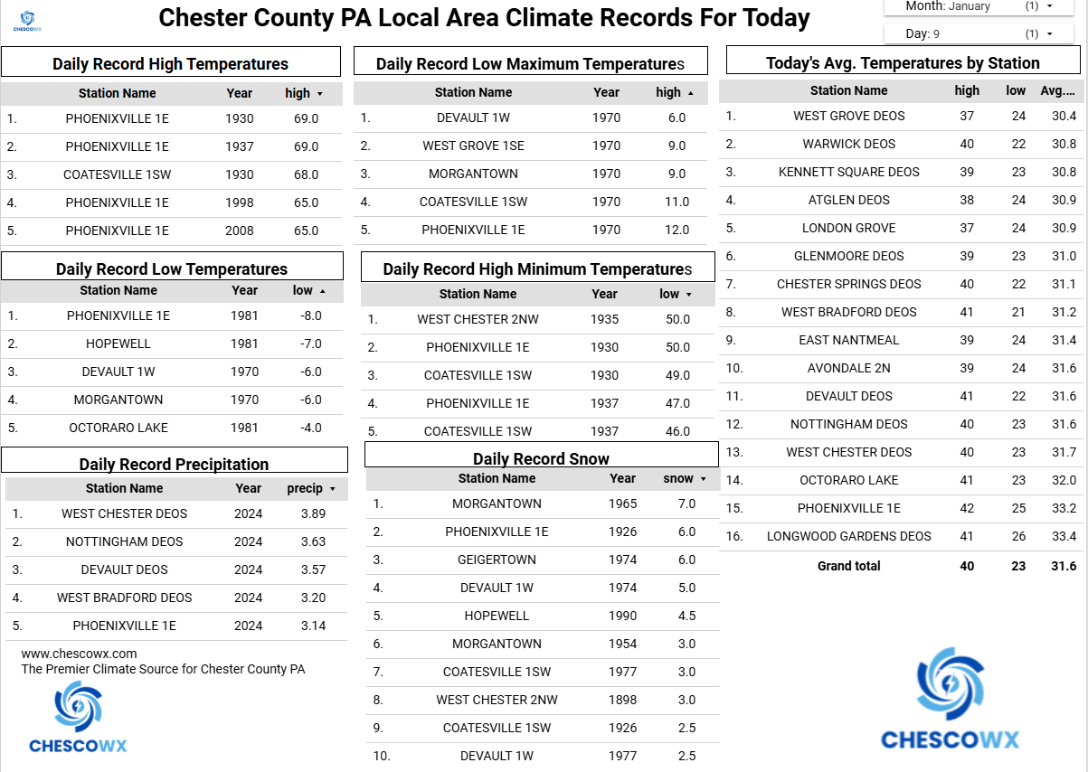
Central PA Winter 25/26 Discussion and Obs
ChescoWx replied to MAG5035's topic in Upstate New York/Pennsylvania
Mild temperatures continue today with rain chances increasing this afternoon. A brief break in the rain tonight before we turn chillier with more rain tomorrow into Saturday night. Temperatures turn colder after Sunday with temperatures not too far from normal for mid-January before trending much colder by the end of next week into the weekend. We could see between 0.75” to 1” of rain tomorrow night. Winter weather opportunities start to ramp up by later next week.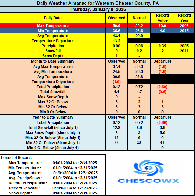

-
E PA/NJ/DE Winter 2025-26 Obs/Discussion
ChescoWx replied to LVblizzard's topic in Philadelphia Region
Mild temperatures continue today with rain chances increasing this afternoon. A brief break in the rain tonight before we turn chillier with more rain tomorrow into Saturday night. Temperatures turn colder after Sunday with temperatures not too far from normal for mid-January before trending much colder by the end of next week into the weekend. We could see between 0.75” to 1” of rain tomorrow night. Winter weather opportunities start to ramp up by later next week.


.png.ee8cfd1927dffa67a98fe35b49c111d2.png)