All Activity
- Past hour
-

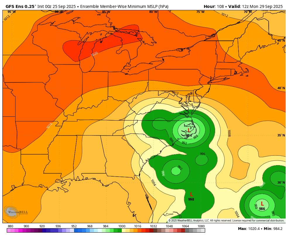
Invest 94L—40% 2 day and 80% seven day odds of development
GaWx replied to WxWatcher007's topic in Tropical Headquarters
0Z GEFS: the most threatening run yet to the SE US (even more than 18Z):
-

September 2025 OBS-Discussion centered NYC subforum
NorthShoreWx replied to wdrag's topic in New York City Metro
I meant how fast it decreases at airports after it is initially reported. -

Texas 2025 Discussion/Observations
Stx_Thunder replied to Stx_Thunder's topic in Central/Western States
Before the taste of fall wx comes in at the end of this week, looks pretty interesting overnight into Thursday morning over STX with the cool front crawling through the region. Already seen near 4 in. rainfall right over the Choke Canyon reservoir under a very decent storm cluster just within the last 2 hours looking at storm totals on CRP radar. In the region near SAT where the drought is still the worst in the entire state. PWs as usual this time of year down here pooling over 2 in. ahead of the front. But H5 flow is about 30 knots now, west-northwest on VWP. So starting to see better storm organization and more frequent lightning and even a few stronger +CGs across the region. Wouldn't rule out a few embedded transient supercells and several inches of rainfall spots overnight with decent mid-upper level support for September standards. Only caveat that's been a fairly common theme this year (even before summer) is once again, meager ML lapse rates. Though Euro seems to be under-doing them a bit lately. -
Invest 94L—40% 2 day and 80% seven day odds of development
GaWx replied to WxWatcher007's topic in Tropical Headquarters
1. 0Z CMC Georgetown, SC hit with 975 mb H as not as strong Humberto (983 mb) doesn’t dominate: 2. 0Z GFS is safely OTS with Fujiwara from Humberto.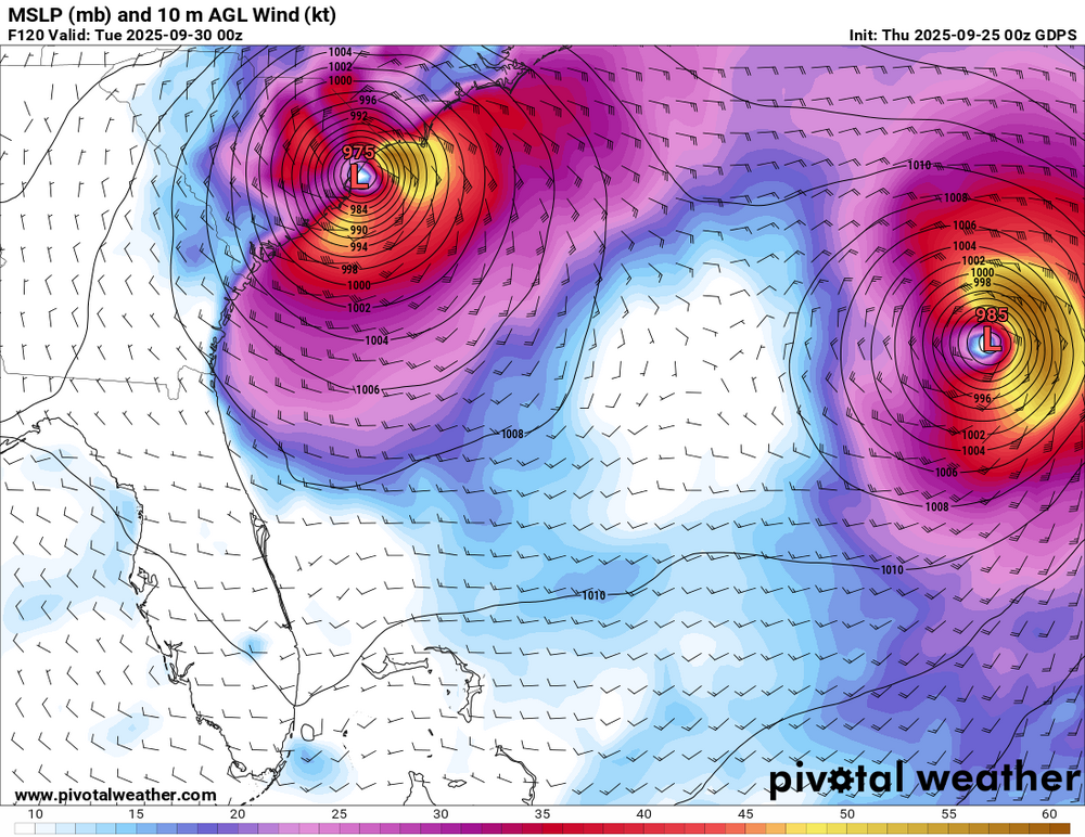
-
Invest 94L—40% 2 day and 80% seven day odds of development
GaWx replied to WxWatcher007's topic in Tropical Headquarters
0Z UKMET: TD forms Mon night NW Bahamas, initially then drifts slowly NW followed by a stall and dissipation as the much stronger Humberto only ~500 miles east takes over: NEW TROPICAL CYCLONE FORECAST TO DEVELOP AFTER 102 HOURS FORECAST POSITION AT T+102 : 25.0N 77.5W LEAD CENTRAL MAXIMUM WIND VERIFYING TIME TIME POSITION PRESSURE (MB) SPEED (KNOTS) -------------- ---- -------- ------------- ------------- 1200UTC 29.09.2025 108 25.9N 78.2W 1008 27 0000UTC 30.09.2025 120 26.1N 78.3W 1007 23 1200UTC 30.09.2025 132 26.1N 78.1W 1007 20 0000UTC 01.10.2025 144 CEASED TRACKING -
Rained a quarter inch in the morning through noon. The morning forecast underestimated the system. But it had been so dry the rain was soaked up quickly and the event was fine to be held. It was hot and humid until the sun went down and then cooled off nicely. .
- Today
-
Invest 94L—40% 2 day and 80% seven day odds of development
GaWx replied to WxWatcher007's topic in Tropical Headquarters
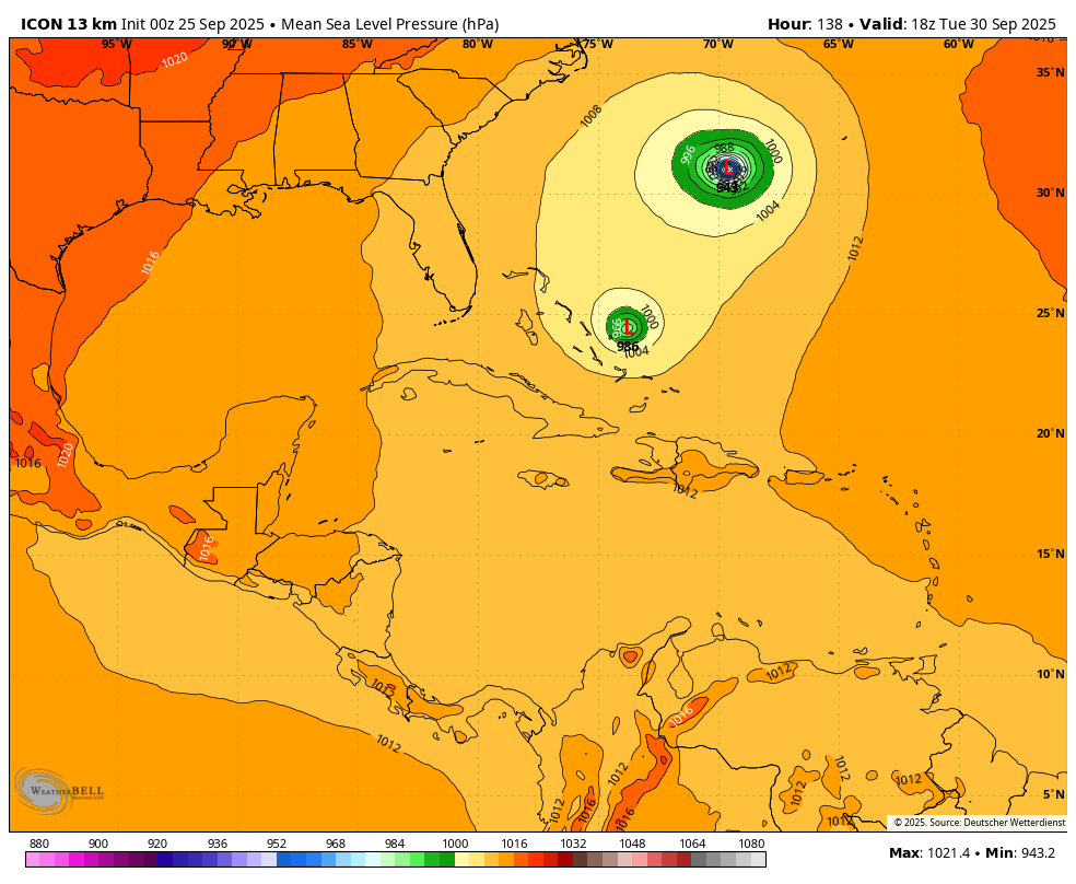
0Z Icon: Humberto pulls 94L ESE to keep it safely away: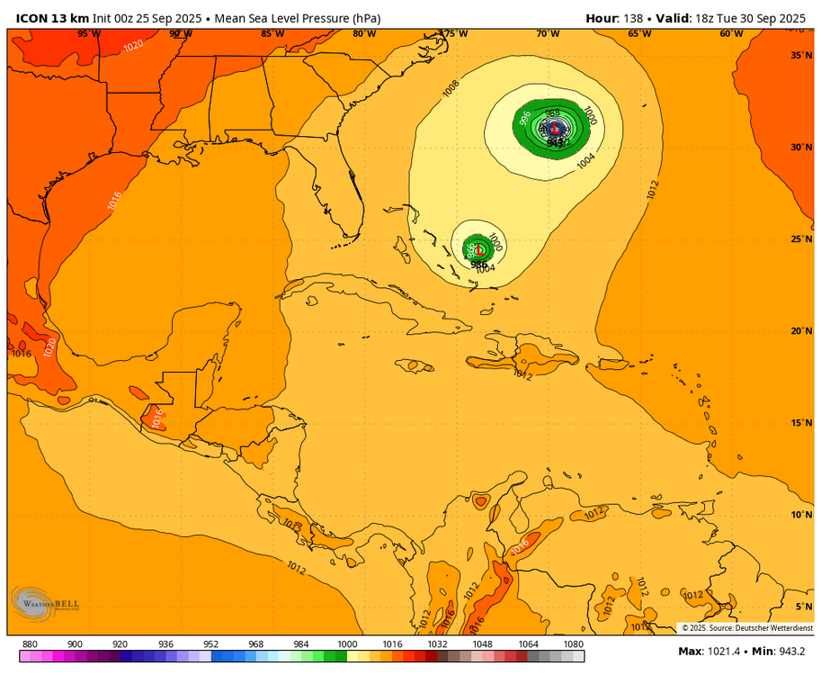
-

E PA/NJ/DE Autumn 2025 Obs/Discussion
KamuSnow replied to PhiEaglesfan712's topic in Philadelphia Region
Raining nicely here, a bit of lightning and thunder. Enjoyable! 0.30" in the last hour. -
Finally getting heavy rain
-
0.95" Didn't think I would see much of anything here until tomorrow.
-
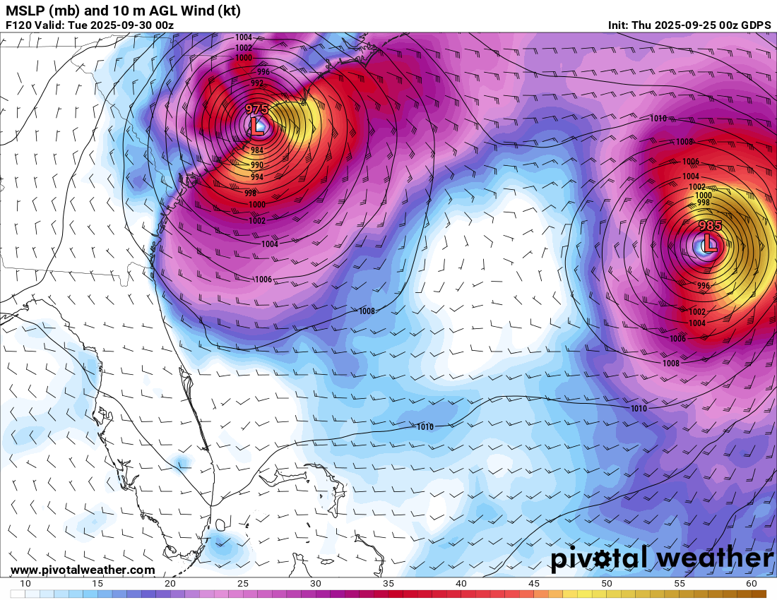
No surprise but officially expected to become our next major now. Tropical Storm Humberto Discussion Number 2 NWS National Hurricane Center Miami FL AL082025 1100 PM AST Wed Sep 24 2025 The cloud pattern of Humberto has changed little in organization over the past several hours. Some rudimentary convective banding features are evident but the cold cloud tops are rather fragmented at this time. Upper-level outflow is being restricted over the western portion of the circulation, at least partially due to the outflow from disturbance 94L located near Puerto Rico. The current intensity estimate is set at 40 kt in agreement with a recently received scatterometer pass. The storm center is not yet very well-defined so the initial motion is a rather uncertain 300/10 kt. Over the next few days, Humberto should be steered generally west-northwestward to northwestward on the southwestern side of a subtropical mid-level high pressure area. The steering scenario for the tropical cyclone will likely become more complicated in 2-3 days due to the interaction with the developing system 94L to the west. The official forecast track is quite similar to the previous one, and roughly in the middle of the guidance. However, due to the likely complications in the evolution of the steering flow, there is lower than normal confidence in this track forecast. Global models suggest that there will be some relaxation in westerly vertical wind shear over Humberto in the coming days. This, along with very warm ocean waters and a moist mid-level air mass, should lead to strengthening. The system will probably become a hurricane in a couple of days, and then strengthen into a major hurricane. The official intensity forecast is in reasonable agreement with the simple and corrected model consensus, including the latest FSU Superensemble forecast. FORECAST POSITIONS AND MAX WINDS INIT 25/0300Z 20.7N 55.8W 40 KT 45 MPH 12H 25/1200Z 21.4N 56.7W 45 KT 50 MPH 24H 26/0000Z 21.9N 57.3W 50 KT 60 MPH 36H 26/1200Z 22.4N 57.9W 55 KT 65 MPH 48H 27/0000Z 22.9N 58.8W 60 KT 70 MPH 60H 27/1200Z 23.4N 60.1W 70 KT 80 MPH 72H 28/0000Z 24.0N 62.0W 85 KT 100 MPH 96H 29/0000Z 26.3N 66.0W 100 KT 115 MPH 120H 30/0000Z 30.1N 68.9W 100 KT 115 MPH $$ Forecaster Pasch/Blake
-

September 2025 OBS-Discussion centered NYC subforum
LibertyBell replied to wdrag's topic in New York City Metro
People who don't live in this area are jealous and always tell me wow you must get great airplane pictures of them taking off and landing. I told them I don't take pictures of air planes for the same reason I don't take pictures of sea gulls, they all look the same to me and once you've seen one you've seen them all. -
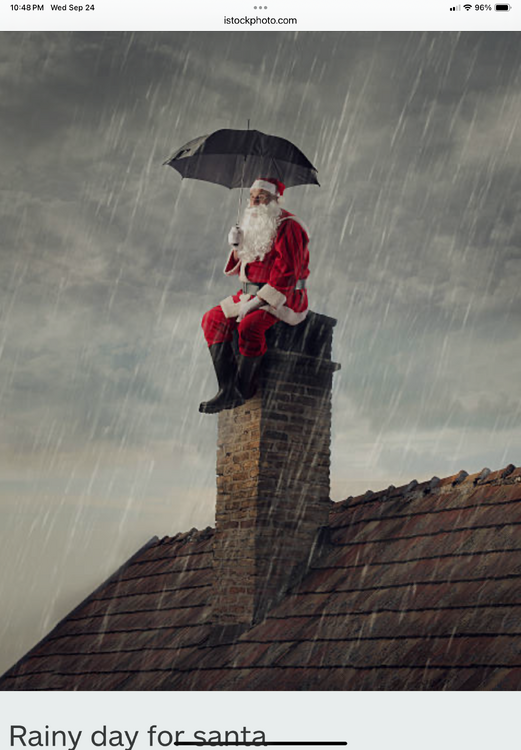
Caution Liberty …… The coal that appears in your stocking may arrive already lit. As always ….
-
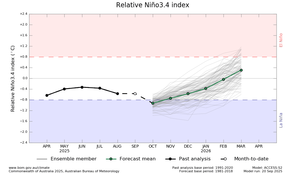
Big news from Australia’s BoM: their model progs have just switched from 3.4 to relative 3.4 (akin to RONI)! Relative Niño indices Traditional Niño index values were used at the Bureau of Meteorology until September 2025. From September 2025, the Bureau uses Relative Niño indices, which measure sea surface temperature anomalies in the tropical Pacific Ocean in the Niño regions, but calculated relative to the global tropical region temperature anomaly. This is to relate the indices more closely to the localised processes associated with ENSO, rather than larger-scale tropical SST features such as global warming. Example: The Relative Niño3.4 index calculation: Relative Niño3.4 = S x [(Niño3.4obs – Niño3.4clim) – (Tropical Meanobs – Tropical Meanclim)] Here’s the latest BoM relative 3.4 model prog for Relative 3.4, which has a low of -0.7C for OND: http://www.bom.gov.au/climate/ocean/outlooks/index.shtml?index=nino34#region=NINO34 @snowman19
-
Getting hit pretty good with this line of storms moving through. Pouring.
-

2025-2026 ENSO
40/70 Benchmark replied to 40/70 Benchmark's topic in Weather Forecasting and Discussion
I agree with you on the meager STJ and active N stream, but not sure why that necessarily hurts the NORTHeast??......Miller B redevelopments can be fine for New England and upstate NY. Last year was brutal here...all set the with STJ "cooperating" as much as it did last year. I'll take my chances with the N stream over watching Baton Rouge to Nashville getting hit. -
Heavy rain and storms are here. Anyone in WNC whose been dry recently will get some much needed rainfall. Those who have seen rain already will be waterlogged.
-
Hopefully good drink for everybody over the interior of New England tomorrow. Looks dry for a while after.
-
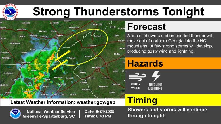
Tonight's hazards. Sent from my SM-G998U using Tapatalk
-
 What was 12z and 18z?
 -

September 2025 OBS-Discussion centered NYC subforum
MJO812 replied to wdrag's topic in New York City Metro
Hopefully we get rain from this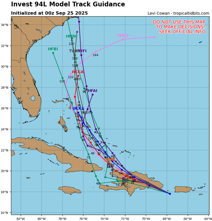
-

-
Invest 94L—40% 2 day and 80% seven day odds of development
MJO812 replied to WxWatcher007's topic in Tropical Headquarters

-

-
Well you mentioned biases good sir--and believe it or not I'm genuinely curious And have I ever attacked you personally? I mean me ribbing ya a bit on this isn't serious, I promise


.thumb.png.4150b06c63a21f61052e47a612bf1818.png)


