All Activity
- Past hour
-
WTNT43 KNHC 262100 TCDAT3 Hurricane Melissa Discussion Number 22 NWS National Hurricane Center Miami FL AL132025 500 PM EDT Sun Oct 26 2025 After an earlier pause in intensification, this afternoon's Air Force Reserve reconnaissance mission has found Melissa intensifying again. The minimum pressure has fallen 12 mb from this morning NOAA-P3 mission, with the last dropsonde indicating a minimum pressure of 941 mb, and the plane reported a shrinking eyewall down to 6 n mi in diameter. In addition to the low pressure, the satellite presentation of Melissa remains very impressive, with 1-minute visible satellite images from a GOES-19 meso-sector showing a very clear eye with a stadium effect. The eye temperature on water vapor imagery has continued to warm, while the thick ring of eyewall cloud tops remains between -75 to -80 C around the eye. The presentation of Melissa on radar reflectivity from Kingston, Jamaica has also improved, though there still appear to be hints of a moat forming around the inner eyewall, though without an obvious secondary eyewall formation yet. Subjective Dvorak CI-numbers from both SAB and TAFB were T7.0/140 kt, with objective satellite estimates between 132-143 kt. However, Melissa's peak winds from the last couple of recon missions have been lagging the satellite-based estimates. The last fix had peak 700 mb flight level winds of only 129 kt, but a dropsonde launched in the north eyewall also reported a 500 m layer average of 142 kt, with an earlier dropsonde in the NE eyewall with a surface wind gust of 131 kt. This data is enough to raise the maximum sustained winds of 125 kt, and given the satellite presentation, this could be conservative. Melissa continues to move slowly westward, estimated at 270/4 kt. The hurricane has been moving a little faster to the west today, and this motion will likely continue for another 12-18 hours while the narrow mid-level ridge to the north remains in place. Soon, a short-wave trough will be moving into the SE United States, and this feature should create a weakness that Melissa will turn sharply northeast into, as it gradually accelerates. The track guidance has shifted a little westward again this cycle, and the NHC track forecast was nudged a little west again, but still shows landfall on Tuesday morning along the south coast of Jamaica. There remain some timing differences thereafter, but a second landfall is anticipated along the southeastern Cuba coast by Tuesday night or early Wednesday morning. As Melissa then accelerates into the southwestern Atlantic, it will move through the Bahamas and potentially approach Bermuda by the day 4-5 time frame, with a reinforcing trough helping to kick it farther out to sea. The latest NHC track forecast is a little west in the first 24-60 h, but falls back near the previous forecast track thereafter. The track is roughly a blend of the reliable HFIP Corrected Consensus Approach (HCCA) and Google Deep Mind ensemble mean (GDMI). Now that Melissa is intensifying again, it seems more clear that the earlier pause in intensification was a temporary oscillation, and the hurricane now appears poised to intensify more in the short-term. The latest NHC intensity forecast shows a little more intensification in 12 h, but continues to show a peak intensity of 140 kt, which is supported by HAFS-B which shows landfall of Melissa as a catastrophic Category 5 hurricane. The Google DeepMind ensemble members also continue to indicate this peak, with now 48/50 members reaching this lofty intensity. However, inner-core processes like ERCs could occur at any time, and the current small eye of Melissa likely suggests an ERC could begin in the next 24 hours or so, though it is very difficult to predict these occurrences with much skill. After landfall in Jamaica, Melissa will likely weaken some due to the interaction with that Island's high terrain, but it is still expected to be a major hurricane when crossing the Cuba coastline on Tuesday night. After emerging into the southwestern Atlantic Ocean, increasing vertical wind shear should continue gradual weakening through the end of the forecast, with the possibility that Melissa could start extratropical transition by day 5. The NHC intensity forecast continues to be on the high side of the guidance, but falls closer to the HCCA and IVCN aids towards the end of the forecast period. ———— Monday. FORECAST POSITIONS AND MAX WINDS INIT 26/2100Z 16.4N 77.2W 125 KT 145 MPH 12H 27/0600Z 16.4N 77.7W 135 KT 155 MPH 24H 27/1800Z 16.6N 78.2W 140 KT 160 MPH 36H 28/0600Z 17.2N 78.2W 140 KT 160 MPH 48H 28/1800Z 18.4N 77.5W 115 KT 130 MPH...INLAND OVER JAMAICA 60H 29/0600Z 20.0N 76.1W 105 KT 120 MPH...ON THE SE CUBA COAST 72H 29/1800Z 22.1N 74.4W 90 KT 105 MPH...OVER WATER 96H 30/1800Z 28.0N 69.5W 80 KT 90 MPH 120H 31/1800Z 37.0N 60.0W 70 KT 80 MPH $$ Forecaster Papin
-
WTNT33 KNHC 262055 TCPAT3 BULLETIN Hurricane Melissa Advisory Number 22 NWS National Hurricane Center Miami FL AL132025 500 PM EDT Sun Oct 26 2025 ...HURRICANE MELISSA RESUMES INTENSIFYING... ...LIFE-THREATENING AND CATASTROPHIC FLASH FLOODING AND LANDSLIDES EXPECTED IN PORTIONS OF JAMAICA AND SOUTHERN HISPANIOLA THROUGH MIDWEEK WITH HURRICANE FORCE WINDS LIKELY TO BEGIN TOMORROW... SUMMARY OF 500 PM EDT...2100 UTC...INFORMATION ---------------------------------------------- LOCATION...16.4N 77.2W ABOUT 115 MI...185 KM SSW OF KINGSTON JAMAICA ABOUT 295 MI...470 KM SSW OF GUANTANAMO CUBA MAXIMUM SUSTAINED WINDS...145 MPH...230 KM/H PRESENT MOVEMENT...W OR 270 DEGREES AT 5 MPH...7 KM/H MINIMUM CENTRAL PRESSURE...941 MB...27.79 INCHES
-
A strong NAO blocking regime is in place and will persist into early November. As a result, an extended period of cooler than normal weather will prevail through the end of the month. Tomorrow will be another cool day. Temperatures will top out in the lower and middle 50s across much of the region. Many locations outside of New York City will see readings start in the 30s. Hard freezes are likely well north and west of New York City. The unseasonably cool weather will continue through at least the middle of the week. Rain could arrive Wednesday night or Thursday. A general 1"-3" rainfall is likely late Wednesday night through Friday. There remains uncertainty about the area of heaviest rainfall. The storm will be followed by a continuation of cool weather. The ENSO Region 1+2 anomaly was -0.4°C and the Region 3.4 anomaly was -0.6°C for the week centered around October 15. For the past six weeks, the ENSO Region 1+2 anomaly has averaged -0.15°C and the ENSO Region 3.4 anomaly has averaged -0.47°C. La Niña conditions will likely continue through mid-winter. The SOI was +30.36 today. That is the first +30.00 or above figure since April 2, 2025 when the SOI reached +35.40. The preliminary Arctic Oscillation (AO) was +1.370 today. Meanwhile the NAO was -1.329. That last time the NAO was -1.000 or below and the AO was +1.000 or above was March 2, 2023. The last time it happened during fall was November 4-5, 2021. Based on sensitivity analysis applied to the latest guidance, there is an implied 51% probability that New York City will have a warmer than normal October (1991-2020 normal). October will likely finish with a mean temperature near 58.0° (0.1° above normal). Supplemental Information: The projected mean would be 1.1° above the 1981-2010 normal monthly value.
-
Just slogging due east.
-
145mph 941 at 5pm
-
That’s a bold statement… I agree .
-
I'll be pissed if they trade him, but that's the word among the pundits. Again, this is a Harbaugh thing. "He is the odd man out". Oh fuck off with that crap. Hopefully he is out after this season, although I doubt it.
-
I’d take one decent pre-Christmas snow over 2 in Jan/Feb. Nothing on earth can match the magic of a good Jeb walk around the neighborhood with a blanket of white and Christmas lights glowing.
-
Would not be surprised to see my first frost tomorrow morning
-
It appears the Google DeepMind model will be one of the winners again. Several other models kept wanting to bring Melissa farther north, in between Haiti and Jamaica or into eastern Jamaica from the east/southeast. The Google ensembles never budged from the wsw/west track to the south of Jamaica.
-
Snoop played great. So fun to watch Keaton Mitchell play. Even if apparently the bears had to know exactly what was coming if he's on the field
-
This is going cat 5. Eye has completely cleared and is perfectly symmetrical. Beast mode activated
-
Next recon is scheduled to be in there around 2330z. Every 6 hours there will be a new recon plane.
-
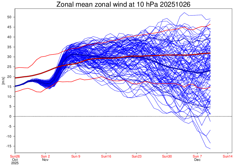
I don’t care what it sees in day to day noise. I’m talking about the overall stratospheric picture going into November here, there is an absence of upward wave fluxes causing warmings and there is zero evidence of any top-down warmings coming. Given those facts, if that’s correct, and it appears to be, the SPV is going to cool and strengthen
-
Today’s Euro Weeklies 10 mb zonal wind update fwiw:
-
Yeah I think we will see some high elevation snow for sure.
-
Yeah as you stated in the mountains thread we will see some high elevation snow the next 5 to 7 days.
-
One nitpick today- the Ravens guard play is still bad, because they made no changes lol. What happened to the open competition during the bye week? Harbaugh hates Ben Cleveland. Just cut the guy. At least Keaton Mitchell got a chance- most likely showcasing him for a trade. I will always and forever want Harbaugh fired because he is a fucking dolt.
-
That'll at least support Upslope. Even flakes into Valley's.
-
Im hoping so. Obviously way to soon to tell and we've seen patterns go to crap quick but I do like the look of the next few weeks.
-
If the Packers beat the Steelers tonight, Ravens would only be 2 games back.
-

Spooky Season (October Disco Thread)
dendrite replied to Prismshine Productions's topic in New England
Anger laced with fear -
Um, I would "guess" that the Eps sees what you're seeing too, so...
-

Spooky Season (October Disco Thread)
CoastalWx replied to Prismshine Productions's topic in New England
Ice free sooner than you think. -

2025-2026 Fall/Winter Mountain Thread
Daniel Boone replied to Buckethead's topic in Southeastern States
Yeah. Possibly measurable snow higher eles. May be even some flakes reach Valley floors if enough caa or heavy precip rates pulls cold air down from aloft.


