All Activity
- Past hour
-
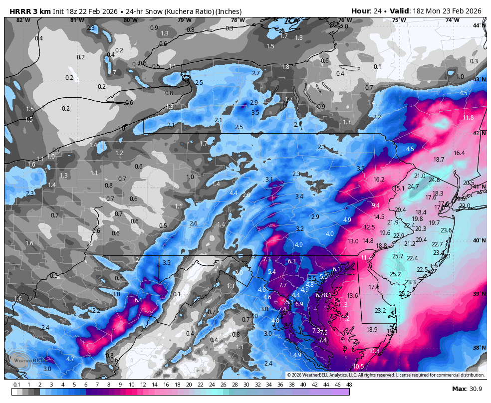
18z HRRR looks amazing

-

Feb 22nd/23rd "There's no way..." Obs Thread
ISeekSnow replied to Maestrobjwa's topic in Mid Atlantic
35/34 temp down 2 degrees in the last 25 mins, snow finally starting to mix in. -

Feb 22nd/23rd "There's no way..." Obs Thread
midatlanticweather replied to Maestrobjwa's topic in Mid Atlantic
Traffic Cam at Bears Den on Rt 7 -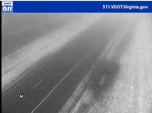
-
Glad the east bleed stopped, but I'd rather see a push back west instead of the status quo. It's looking more and more like I'll be in the dreaded subsidence zone
-

Feb 22nd/23rd "There's no way..." Obs Thread
DDweatherman replied to Maestrobjwa's topic in Mid Atlantic
It’s an imby sport always, isn’t it? We all want the Ivt. I can tell you it won’t end up over my yard, but I’m rooting for it to. They always end up east…but the low isn’t pulling east too much so who knows. Current mesoanalysis on spc has it a bit west of modeling. -
Still light snow falling. Not sticking in street with all the salt. Temp down to 29.9F. Kind of glad we haven't had any heavier snow yet. I want my temp to go down to 25-28 so it will be powdery like usual.
-
just right click the image and copy url link paste into your browser https://sirocco.accuweather.com/nxssa_r1_h_500x620d/r1h/inxr1Kphla_h.gif
-
There's going to be a big band somewhere just north of you into Sussex County imo
-

Southern MD / Lower Eastern Shore weather discussion
Lowershoresadness replied to PrinceFrederickWx's topic in Mid Atlantic
hey we popped that orange chat box hot. we must be getting a good storm -

Southern MD / Lower Eastern Shore weather discussion
SnowtoRain replied to PrinceFrederickWx's topic in Mid Atlantic
Eyeballing 1" -

“Cory’s in NYC! Let’s HECS!” Feb. 22-24 Disco
Go Kart Mozart replied to TheSnowman's topic in New England
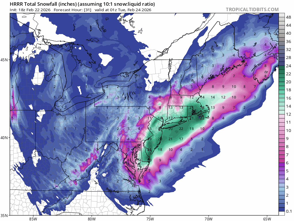
Wow, look at NW Jersey on HRRR. Maybe I need to root for the storm to go much further east, lol.
-

Feb 22nd/23rd "There's no way..." Obs Thread
EHoffman replied to Maestrobjwa's topic in Mid Atlantic
My hood is literally right outside of the purple. I could walk to the purple though lol -

“Cory’s in NYC! Let’s HECS!” Feb. 22-24 Disco
Ginx snewx replied to TheSnowman's topic in New England
Hoth is a resident worrier -
surely its not gonna be like 10 miles across right
-
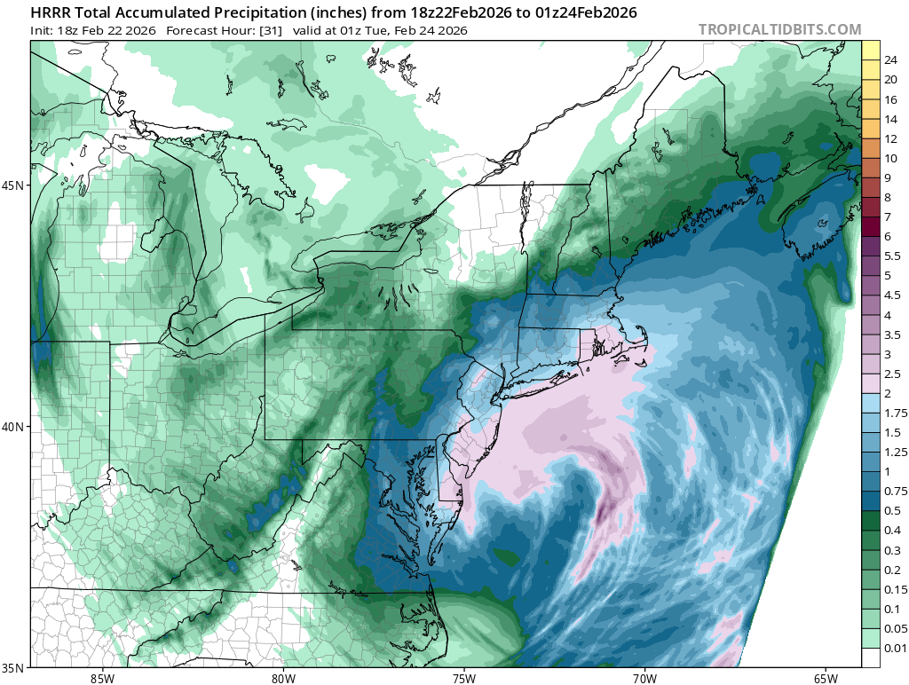
HRRR and RAP are actually quite impressive QPF wise for PHI. 2” and 1.7” respectively with some to come on RAP yet.
-

Feb 22nd/23rd "There's no way..." Obs Thread
nw baltimore wx replied to Maestrobjwa's topic in Mid Atlantic
Nobody knows it yet, but you, Mappy, me, and the Columbia crowd are getting the norlun. -
More significant mixing now. Temp down to 36.1.
-
Southern MD / Lower Eastern Shore weather discussion
SnowtoRain replied to PrinceFrederickWx's topic in Mid Atlantic
Thanks. -
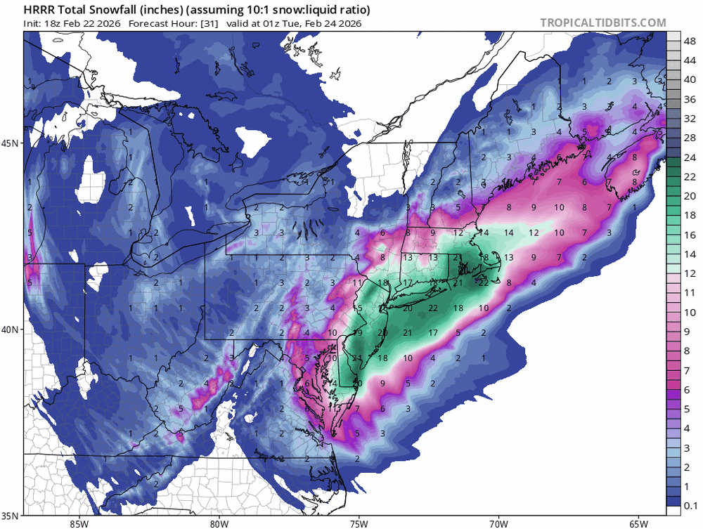
18z 10:1
-
I wouldn’t even know which direction to look lol. been up there many times, there are several ski areas that you can see, and I’ve never been able to figure out which is which. Pats and Crotched for sure
-

Feb 22nd/23rd "There's no way..." Obs Thread
Terpeast replied to Maestrobjwa's topic in Mid Atlantic
If this is correct (which is still an open question), someone in NW dc and alexandria is going to get pummeled -
Gusts to 70mph... Southern New London-Northeast Suffolk-Southeast Suffolk- 122 PM EST Sun Feb 22 2026 ...BLIZZARD WARNING REMAINS IN EFFECT UNTIL 6 PM EST MONDAY... * WHAT...Blizzard conditions. Additional snow accumulations between 18 and 23 inches. Winds gusting as high as 60 mph. Isolated gusts up to 70 mph are possible late tonight into early Monday morning. * WHERE...In Connecticut, Southern New London County. In New York, Northeast Suffolk and Southeast Suffolk Counties.
-
Just a lot of support from better near term guidance showing the major global models were too east .
-

Feb 22nd/23rd "There's no way..." Obs Thread
stormtracker replied to Maestrobjwa's topic in Mid Atlantic
Ah, right through my hood. Oh well -

Feb 22nd/23rd "There's no way..." Obs Thread
NorthArlington101 replied to Maestrobjwa's topic in Mid Atlantic
Only 7 hours to go!
.thumb.png.991e09c19c25af7391ed569a205a5136.png)