All Activity
- Past hour
-

Possible coastal storm centered on Feb 1 2026.
SouthCoastMA replied to Typhoon Tip's topic in New England
That's going to be there. The question is how far can it slingshot up to affect parts of SNE. Looked in better position based on higher heights and trough orientation. we'll see -

The “I bring the mojo” Jan 30-Feb 1 potential winter storm
HKY_WX replied to lilj4425's topic in Southeastern States
He says a lot of things. -
3K NAM is a thing of beauty for us guys!
-

Possible coastal storm centered on Feb 1 2026.
Kitz Craver replied to Typhoon Tip's topic in New England
F that thing. That’s what it latches onto and starts the NE skirt -

The “I bring the mojo” Jan 30-Feb 1 potential winter storm
Regan replied to lilj4425's topic in Southeastern States
Webb started it. Everyone is sharing his post from late last night. Hope we figure it out soon and still we all should be prepared for anything. -
Still way too high.. 20% of 6+ no way
-
Meteorologists are about as consistent as the models they use
-

The “I bring the mojo” Jan 30-Feb 1 potential winter storm
Snowncanes replied to lilj4425's topic in Southeastern States
Athens east unfortunately. At least verbatim. Upper low still closes off too late for y’all atlantans -
 Wouldn't it be funny and ironic if after Randy unpins this thread, then all of a sudden the storm pulls west on models
 -
Here's Mount Holly's latest excerpts concerning the NBM: Area Forecast Discussion National Weather Service Mount Holly NJ 612 AM EST Thu Jan 29 2026 ...When compared to Wednesday, the latest (01Z) NBM probabilistic data has remained steady near the shore but trended down for places close to the Delaware Valley. For snow amounts greater than 2 inches (plowable), the range remains around 60-70 percent near the coast to 25-35 percent near the I-95 corridor with lower probabilities N/W of the urban corridor. For 6+ inches, these probs have dropped and are now around 20 percent near I-95 up to 35-50 percent near the coast.
-

Possible coastal storm centered on Feb 1 2026.
ineedsnow replied to Typhoon Tip's topic in New England
Ya but that stupid Bahama low is going to mess.things up again -

Possible coastal storm centered on Feb 1 2026.
WinterWolf replied to Typhoon Tip's topic in New England
He’s another silly fool alarmist whose ideas are going by the wayside…but let’s get back on topic with winter weather…which there is plenty of. -
 It is look better this run, not sure if it would be enough to matter for us.
 -
 NAM look okay for north ga?
 -
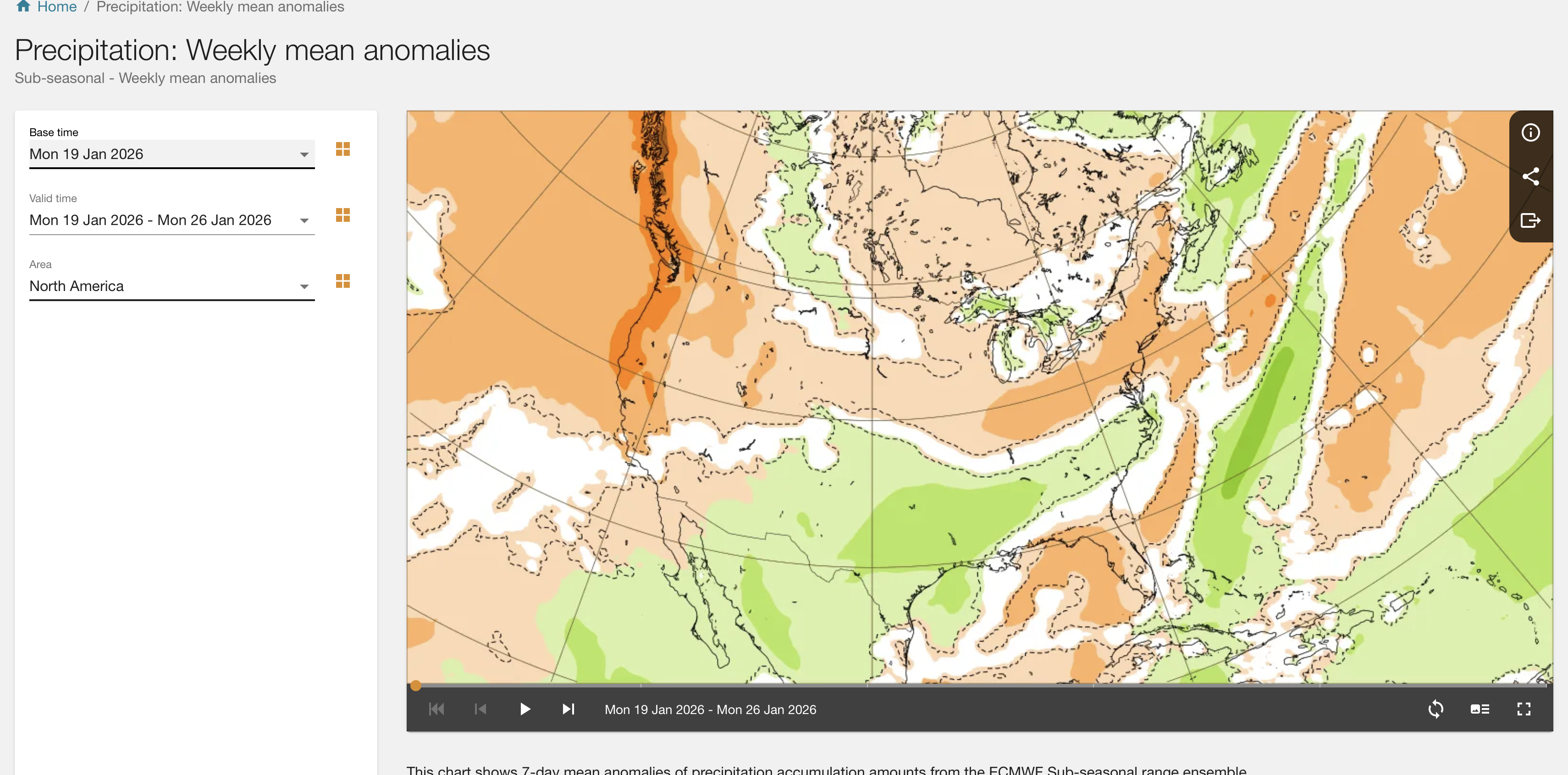
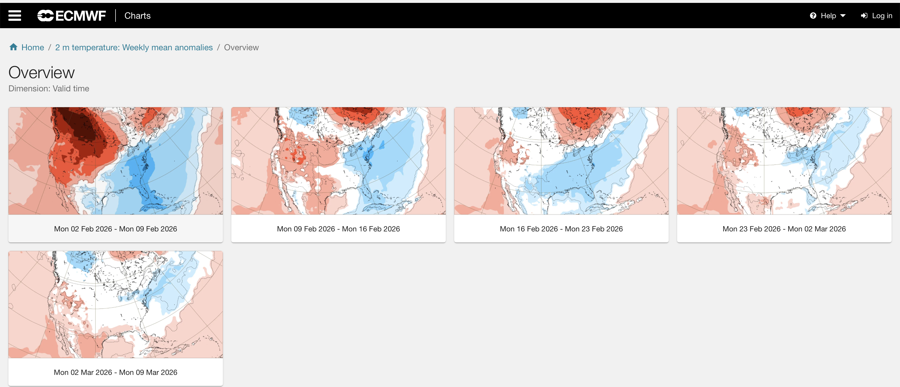
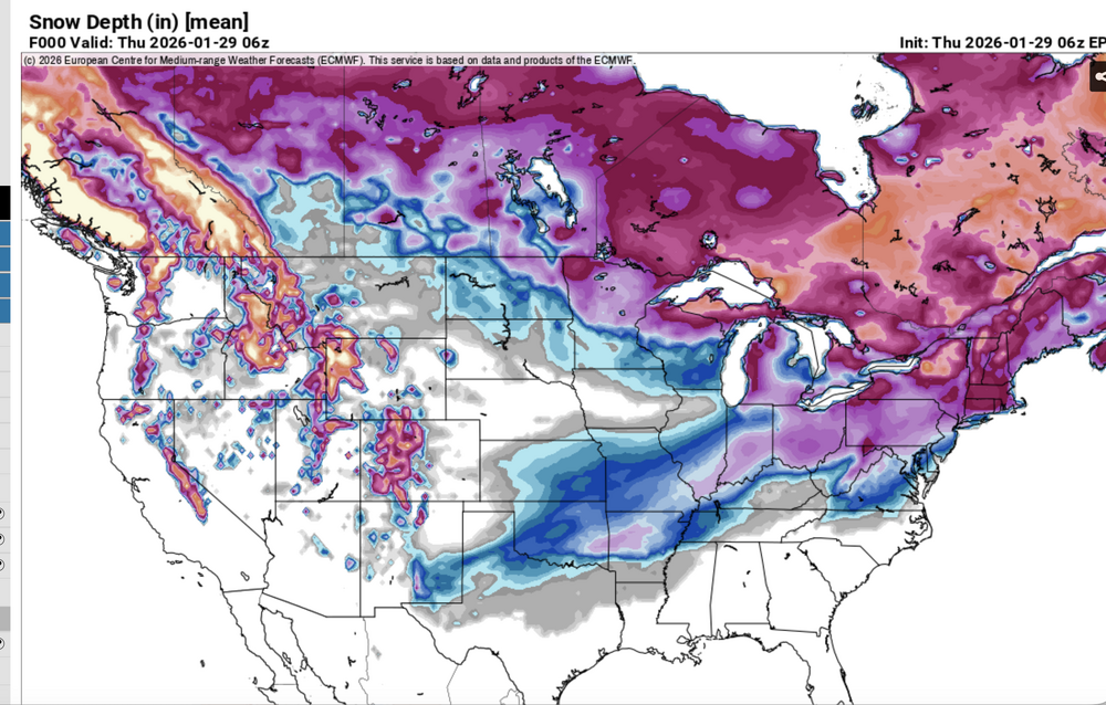
A few notes: ECMWF sub seasonal ensembles via ecmwf.int. imo tend to be too dry here in the northeast and deny the shorter range global ensemble expectations. Be alert for that. Huge error this past weekend - see attached ecmwf.int prediction the 19th, and you know what happened! Also fwiw: via ECMWF.int. Week 3-4, 2m temp departures, I suspect are related to snow cover... see the daily prediction of colder than normal-here ne USA and OH Valley, and where the snow depth is this morning (and the southern boundary likely to be close to that 16 days - Valentines Day) from now. GFS MOS (MEX. I have no access ecmwf mos. GFS MOS is missing too warm on nighttime lows NYC CP... this I think will be a factor on getting much colder than morning MEX MINS this weekend as the BL wind tends to go northernly---easier access CP. Still try for 2-3F above zero.

-

The “I bring the mojo” Jan 30-Feb 1 potential winter storm
Buddy1987 replied to lilj4425's topic in Southeastern States
@BornAgain13 you would def approve of the 12Z NAM for our areas. the elongation/vort digging on the backside is helping up here to enhance precip. Coastal gets going at 51 and is tucked in a little more. Nice ribbon of snow breaking out for RDU folks. To @HKY_WX point, with the ULL going negative, someone is scoring nicely. That thing is a full closed contoured bully and going negative. -
Where I’m situated on the most southern tip of the province we generally get shafted with rain and such. So far it has been a perfect setup for us since the pattern flip a week ago, the Sunday storm plus 4-5 inches of ocean effect squalls has really added up. For now I’m in about the best position possible for this system, we shall see.
-
I don't think any model even shows this!! Maybe he's using the Cras model
-

Possible coastal storm centered on Feb 1 2026.
gonegalt replied to Typhoon Tip's topic in New England
StabbyStab busy with antifa duties. Can't carry phone during insurrections. -
My father always tells me that in the winter where he was growing up near Waterford, Connecticut, once it snowed the roads stayed snow covered for the rest of the winter. How is that possible? I know that the climate has gotten a lot warmer since the 60s but even still there must have been at least a few milder days that melted all the snow off the roads? The only other possibility that I can think of is did they not salt the roadways back in the 60s and that's why they stayed covered? That just doesn't seem possible though. How could people have driven rear wheel drive with snow covered roads?
-
 Yea, this might be kind of funny.
 -
The “I bring the mojo” Jan 30-Feb 1 potential winter storm
HKY_WX replied to lilj4425's topic in Southeastern States
If you're a RDU IMBY, typically in these scenarios, central NC does very well if the UL vort goes negative. This pours in the Atlantic moisture, that's why all the runs over the past few days which showed the highest totals around RDU also featured the system going negative over Tennessee. This is what happened in Jan 2000. The conjecture around the dry slot is just twitter BS imo until we know how this vort will behave. There are still some quirks to go. -
And it looks much better than 0z .
- 269 replies
-
- 1
-

-
- extreme cold
- snow
- (and 1 more)
-

The Jan 31 Potential: Stormtracker Failure or 'Tracker Trouncing
BristowWx replied to stormtracker's topic in Mid Atlantic
is it really or is that poppycock? -
The “I bring the mojo” Jan 30-Feb 1 potential winter storm
Regan replied to lilj4425's topic in Southeastern States
Maybe I’m wrong but he’s not showing a “dry slot” over central Nc. At least as extreme as some. Even Allan, he’s got the big numbers but I disclaimer in C zone that it could happen. As said prior, he sees at least 2-3 (if there’s a slot) in Raleigh per an exchange with someone on x.