All Activity
- Past hour
-
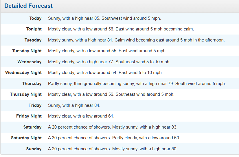
I guess we are doing June in October again. This could be forecast for the week of Father's Day or the 4th. Not so much for October 1st. At least the days are nice though. Just to think, we have the same daylight as ~March 10th rn, where we can have a foot of snow on the ground and 20 degree highs.
-
Spooky Season (October Disco Thread)
Great Snow 1717 replied to Prismshine Productions's topic in New England
even into the first month of winter(November) ??? -
They were +15 on the high and only +11 on the min
-
Looks like some prime biking and hiking weather coming up. Every now and then I hit up Weverton for a quick hike.
-
BOS put up a +13.3 yesterday, driven by the high low temps. Now at +0.4F MTD ORH is at +1.6F MTD
-
Quit whining like a child
-
I'd add to this discussion that these indices are also increasingly non-resonant. Meaning, they are less (apparently...) physically forced into quasi-stable mode. The reason for that is related to the increased winter time gradient in the whole sale integral of the subtropical to Ferril latitude band. Faster basal flow velocities sends the Roulette wheel spinning more frequently - metaphor.
-
That lower sun angle parboiled me as I drove to BGR and back, especially the return trip at 2:30-4 PM. The car's failed A/C added to the oppressive effect, even with temps near 80 rather than 90s.
-

2025-2026 ENSO
40/70 Benchmark replied to 40/70 Benchmark's topic in Weather Forecasting and Discussion
Stratospheric Reflection events, which are triggered by Pacific trough regimes, trigger a transition to AK ridging and colder patterns across the CONUS. They are more common in +QBO seasons (30/44 since 1980), which is maybe what snowman was getting at....but I am going against the grain a bit in feeling as though we get one due to the prevlence of them in my analogs. Usually very warm a few days prior to a few days after the start, but it begins turning colder quickly....so I guess you could say mid January warmth. Early to mid-January, anyway. -
Thank you for making this fun table for 14 years. I doubt that many knew how much work and $$ it took to keep it working. May you have a low-stress winter with some big 'uns.
-
Occasional Thoughts on Climate Change
Typhoon Tip replied to donsutherland1's topic in Climate Change
You have to consider the total geology of Earth in the model/differences comparing the two oceanic basins. The NE Pacific arc is blocked off from the arctic by Alaska and the continental rise - identified by arced Aleutian archipelago of islands. The arctic waters are prevented from intermingling. Additionally, the NW Pacific arc is girded by the Siberian Peninsula. There is a gap between, but it is very shallow - the Bering Straight. In fact, ...over the last ice advance cycle of the greater Pleistocene epoch, it is theorized that the ocean levels, having fallen crucial distance, exposed a 'land bridge' that assisted animal migrations between Asia and North America. Many ancient native America human populations are believed to have arrived via the land bridge route during these lower oceanic level time spans.. Anyway, that sub-surface geology blocks the Pacific from establishing an "AMOC" of its own. Compared to the N Atlantic Basin, where deep oceanic floor abruptly abuts the Greenland landmass. Very cold water due to intermingling with the Arctic happens there, where it really can't happen in the far N Pacific Basin. The cold water is heavy ... it falls to the bottom of the ocean - organized in 'chimneys', these tubes of very cold water plummet to the ocean floor. The falling motion pulls the surface water into replace, due to conservation of mass; and since their is less obstacle to fluid flow, S, that encourages a surface motion that is preferential from the Equator toward the N. The ongoing pattern of wind stress and Coriolis then organizes the large scaled anti-cyclonic motion of the Basin. The Gulf Stream and the Japan currents of either Basin are artifacts of the same wind stressing and Coriolis balancing, but the Atlantic has this AMOC machinery that the Pacific does not. Because of all this... the Pacific distribution of upper oceanic heat content is shallower, thus .. can be thermally modulated faster. Might be a little counter-intuitive when knowing that the Pacific is larger than the Atlantic by a several factors of total mass and surface area, but AMOC has a vastly deeper Z-coordinate in the total integral. -
https://x.com/bam_weather/status/1972640087235232099?s=46 .
-
DocATL started following Fall 2025 Banter Thread
-
Yup...that's a nice shot of colder air modeled.
-

2025-2026 ENSO
40/70 Benchmark replied to 40/70 Benchmark's topic in Weather Forecasting and Discussion
Well, the warmth usually preceedes reflection events due to a Pacific trough regime, so if you have one mid month, the warmth would be earlier...maybe 2nd week? But really no need to split hairs at this range. -
It’ll be freeze chances up here late week.
-
early in January? wouldn't that be later on in mid-late january
-
How I missed the low clouds and onshore flow yesterday. Good to see it's back again.
-
The ragged eyewall does look like it collapsed per recon, but that's not really a surprise given IR last night. I do agree that the presentation has really improved and the pressure falls have been impressive.
-
Da fuk? Lol It looks like we're lucking out and the heat is going to stay in the Midwest this week. Looks like a nice weekend coming up. I'm hiking the MD section of the Appalachian trail.
- Today
-
We uninstalled weeks ago and haven't looked back.
-

E PA/NJ/DE Autumn 2025 Obs/Discussion
LVblizzard replied to PhiEaglesfan712's topic in Philadelphia Region
These dry periods are aligning nicely with my job as a college tennis ref. It always sucks to move a match or tournament indoors since that often means much longer days. I do really hope we get some good rain in the coming weeks though. We just really need a 3-4 day period of steady light rain. Feels like we haven’t had that in forever. -
Honestly this storm had organized at a quick pace overnight with pressure falls and a the center under the CDO. Think pace of intensification quickens through the day
-
September 2025 OBS-Discussion centered NYC subforum
TheClimateChanger replied to wdrag's topic in New York City Metro
1989 - Seven cities reported record high temperatures for the date, as readings soared into the 80s and low 90s in the Northern Plateau and Northern Plains Region. Record highs included 91 degrees at Boise ID, and 92 degrees at Sheridan WY. The high of 100 degrees at Tucson AZ marked their 51st record high of the year, and their 92nd day of 100 degree weather. (National Weather Summary) Seven? We had more than that yesterday. These are from RERs, so there could be some missing and the temperatures might vary higher than given. San Juan, PR: 95F Naples, FL: 94F Augusta, ME: 83F Portland, ME: 85F Allentown, PA: 86F Reading, PA: 87F Fort Wayne, IN: 89F New Philadelphia, OH: 87F DuBois, PA: 80F Marquette, MI: 79F New York (LaGuardia), NY: 85F Glens Falls, NY: 85F Albany, NY: 85F Newark, NJ: 89F Islip, NY: 84F Manchester, NH: 86F Additionally, Key West, FL had a record warm minimum of 83F. -
Agree with this. I will say that some of the AI models earned a little more respect with me this season, but to your point--it's going to take time to truly get a sense of how well it analyzes critical forecasting factors over the long term. Every forecast is different and every TC is a distinct entity. And at any rate...models are merely tools. So us laypeople should beware relying on any one as gospel in any situation. (not saying that anyone here is necessarily doing that)


