All Activity
- Past hour
-

October Comes Early: Late September Multi-Hazard Hybrid Storm
Great Snow 1717 replied to WxWatcher007's topic in New England
Beach Pizza for you??? -
 cheap viagra: Silden Direct - Viagra online price
 -
https://sildendirect.shop/# Viagra without a doctor prescription Canada
-

October Comes Early: Late September Multi-Hazard Hybrid Storm
ineedsnow replied to WxWatcher007's topic in New England
Stopped at salisbury before going to hampton.. pretty gusty now -
At some point we will get a big snowstorm again. I am not saying it will never snow again. However, we are in a hostile PDO cycle. You can track these long term cycles and see the impact on our snowfall. The issue is the hostile periods are becoming MORE hostile. It's becoming VERY difficult to get big snowfall years during hostile cycles. It was never easy during hostile pacific cycles but now its becoming increasingly unlikely to even luck into some fluke snowy seasons during a hostile period. Eventually we will... I don't think it's impossible just less and less likely. And eventually the PDO will flip again and we will have a more favorable cycle and probably a period of 15-20 years with "more" snowfall but the last 2 favorable cycles showed a decrease from period "snowy" cycles also so don't expect another 1960's or even another 2000-2016 period. But we will see snowier periods than what we've just experienced again. But my point is using past "normal" trends to set expectations is flawed since we know things are changing and becoming more hostile.
-
I mean at least if this one doesn't produce there's a known reason (super east based). Does it belong in the same category as the other two? What does bother me is how a switch suddenly flipped in 2016. Yeah I know the snow margins overall were going down in the two decades before...but that period of time still had footers (what I call storms over 12") every 3-4 years, with that heater between 2010-2016. Then after 2016 and it all just stops cold. No slow decline, just outright stops...I thought climo change was supposed to be gradual? Lol That's what makes me wonder if the super niño back then accelerated things, or made the atmosphereor can this one "reset" things once again? But if the next niño after this one behaves the same way the previous two did then yeah we might be cooked, smh
-
October Comes Early: Late September Multi-Hazard Hybrid Storm
Great Snow 1717 replied to WxWatcher007's topic in New England
I agree the majority of storms will have overs and unders but can't the forecasters adjust their forecasts based on what is actually taking place? -
1.60" for the day and event total 2.67" so far. 7.61" for the month
-

October Comes Early: Late September Multi-Hazard Hybrid Storm
Typhoon Tip replied to WxWatcher007's topic in New England
Part of the issue is that any precipitation event is background favored to over perform over quantitative/guidance-based QPF totals. This is an unavoidable aspect of CC. This storm performed pedestrian as far as Nor'easter/coastal event climatology, but over performed on QPF relative to that. It seems the relativity aspect doesn't filter analytically by many when it comes to assessing forecast. Like Wiz was intimating, ...all storms will have over and unders, and right ons. What you can do is determine the axis of modeled QPF or wind or surf ... vs whichever metric being studied. Then, plot all the empirical results on a bell-curve graph. Super impose the two graphs. If the interquartile density of results is left of the storm forecast axis/max, the system under performed. If it is over the max, it over performed. If it's closely spaced then it performed according to the guidance profile/projection. -

Strong Nor'Easter/Hybrid Storm Late September 2026
Brian5671 replied to Rjay's topic in New York City Metro
with 3 months to go, 60+ is not out of the question if we remain in this very wet pattern -

E PA/NJ/DE Autumn 2026 Obs/Discussion
JTA66 replied to PhiEaglesfan712's topic in Philadelphia Region
Finished with 1.60”. 63F/DP 60F -
My son has had 2 games so far. Yeah this weekend not looking good lol
-
cialis generic: TadaStreamRx - Generic Cialis price
-
42 two mornings in a row. Hopefully this week's warm up is limited to this week.
-
Certainly going with quantity and not quality this season.
-

Strong Nor'Easter/Hybrid Storm Late September 2026
MANDA replied to Rjay's topic in New York City Metro
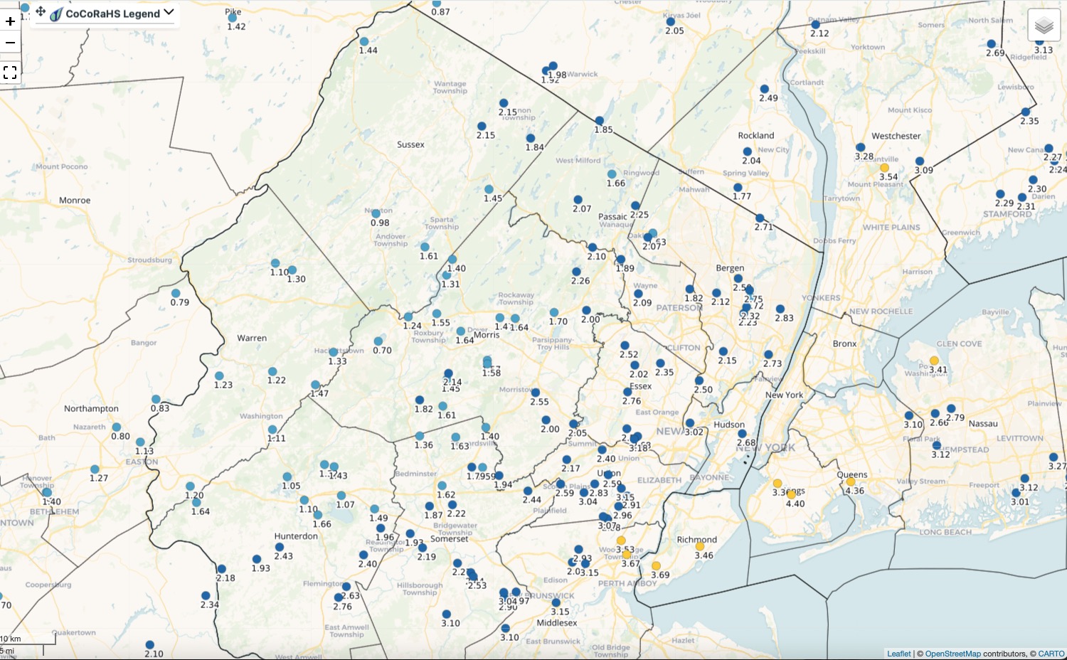
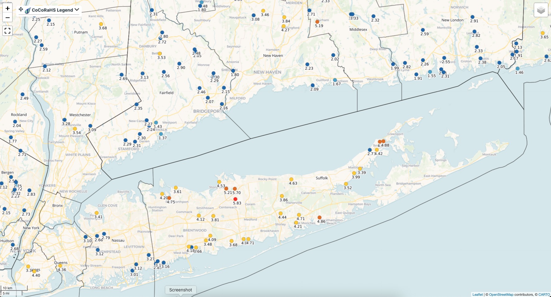
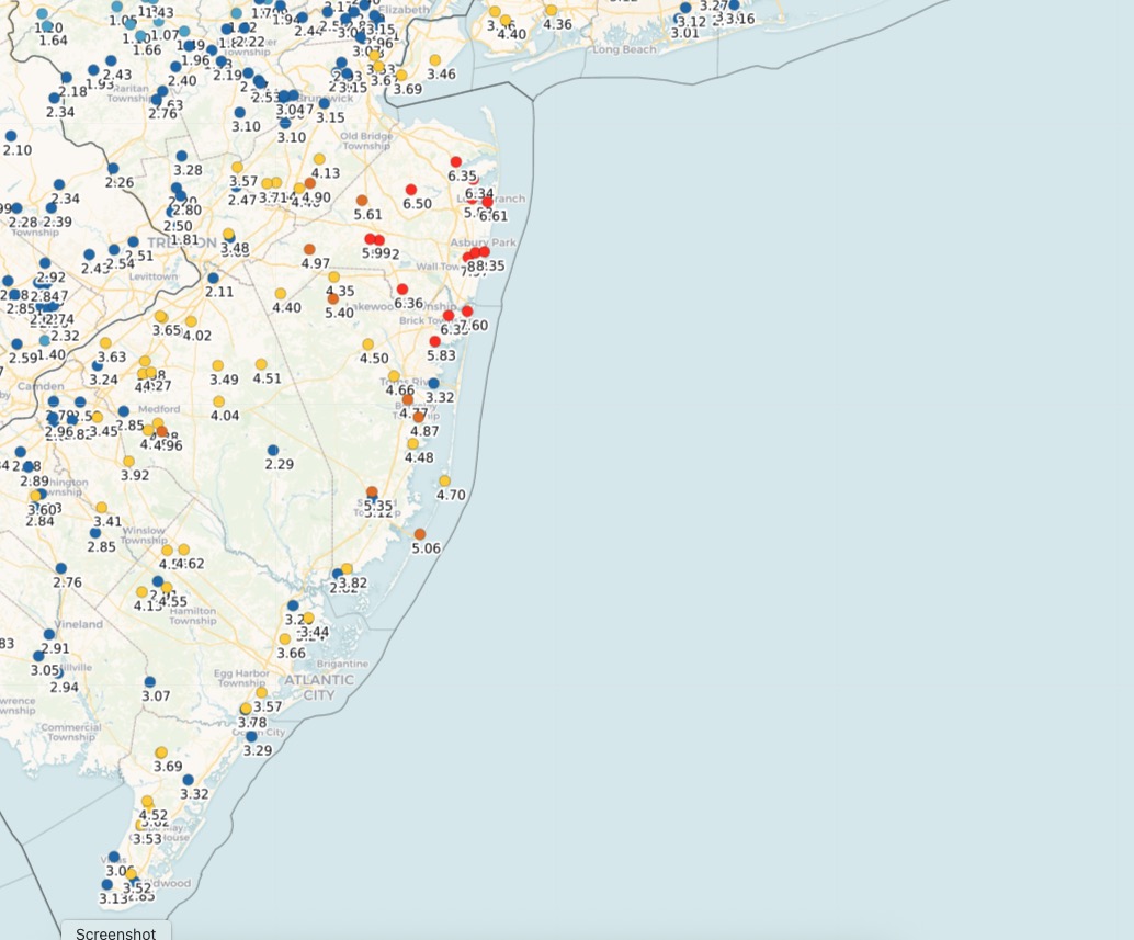
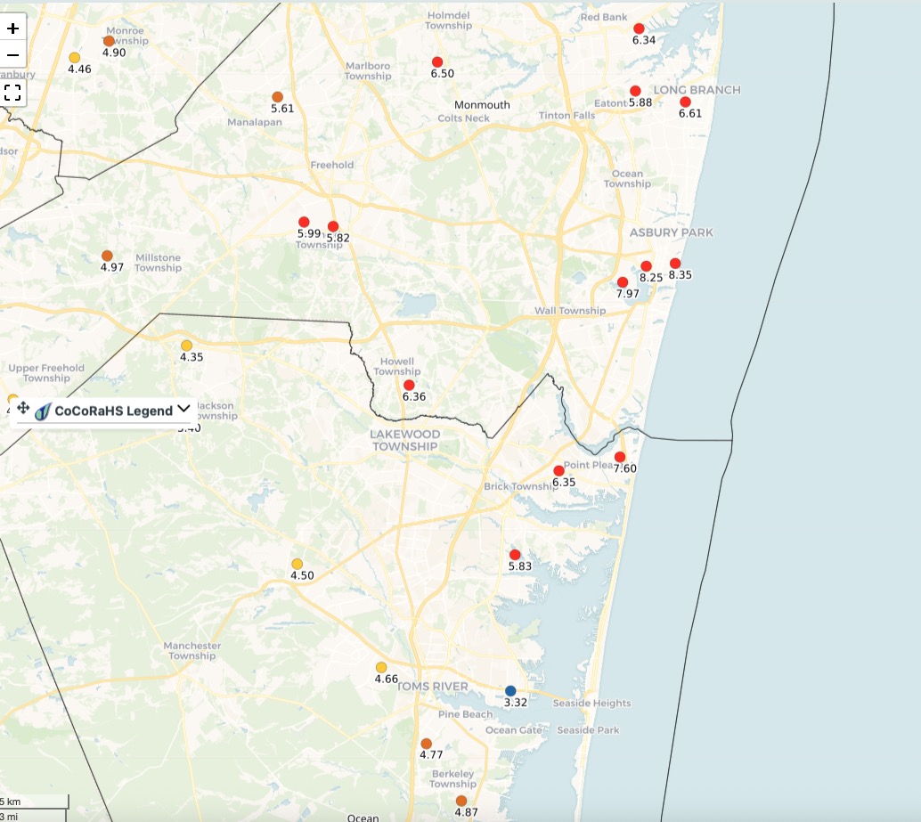
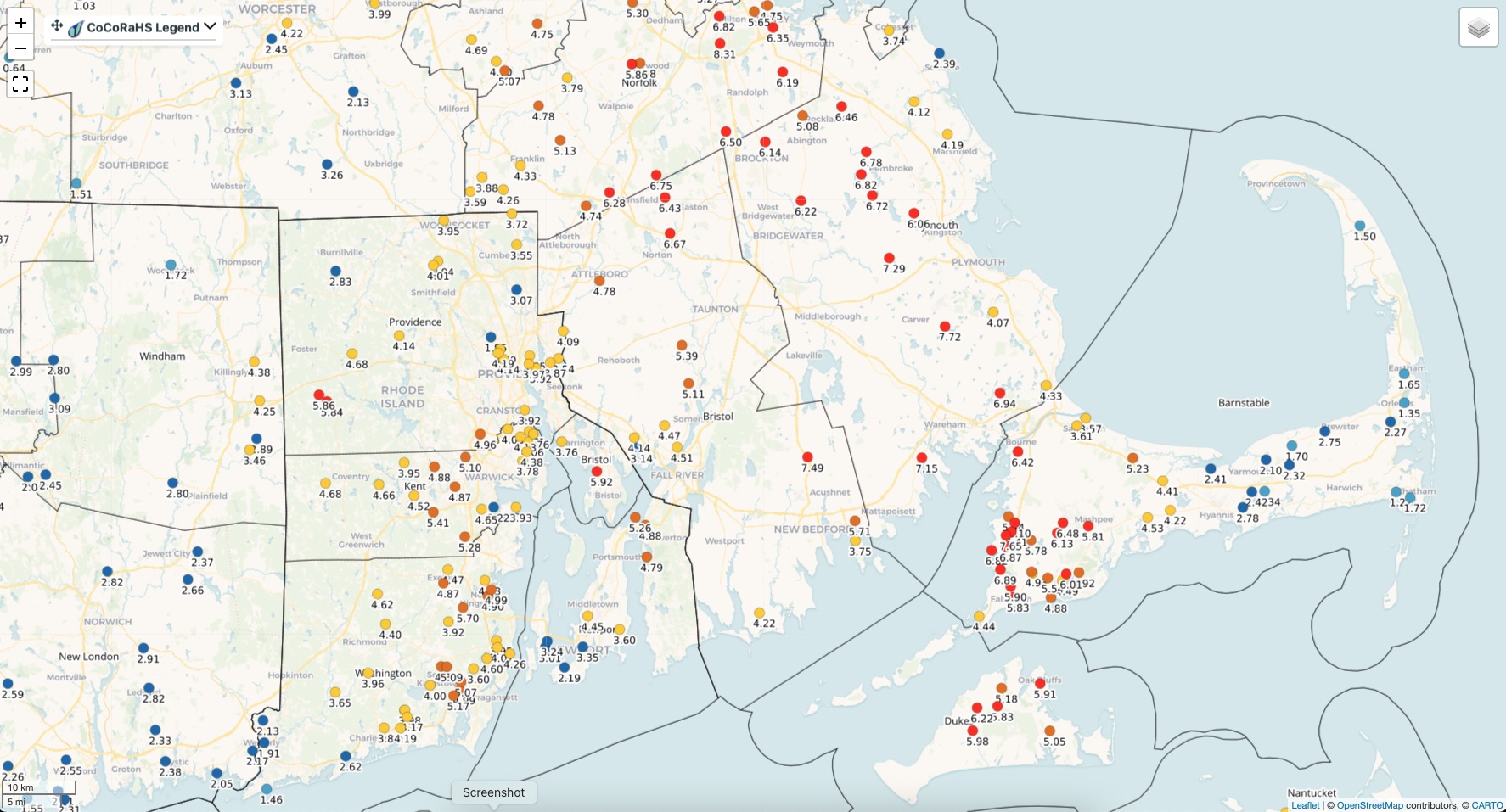
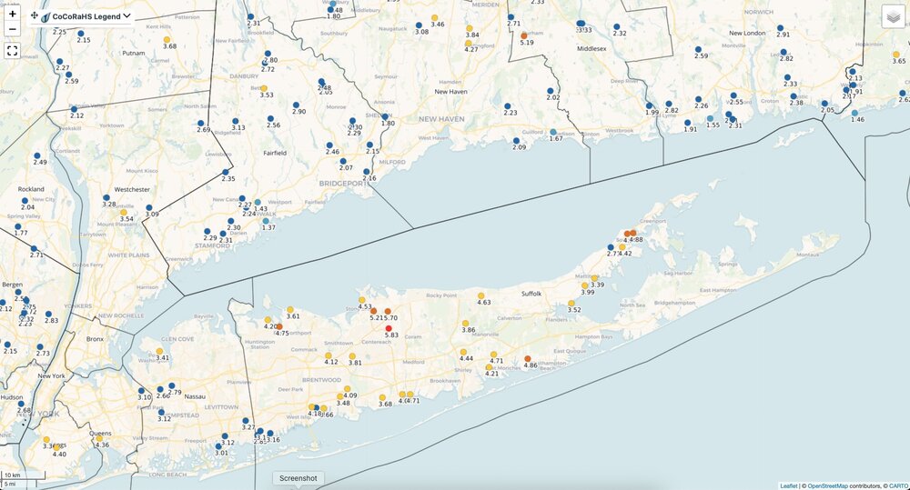
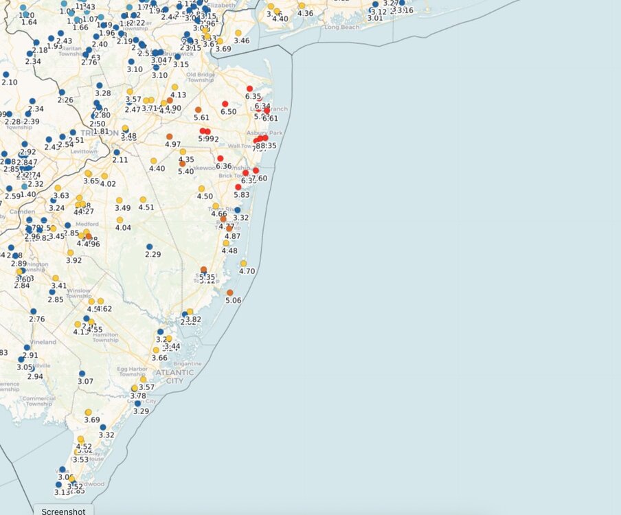
Three day event totals: Some 7-8" totals scattered around in there. Click maps to enlarge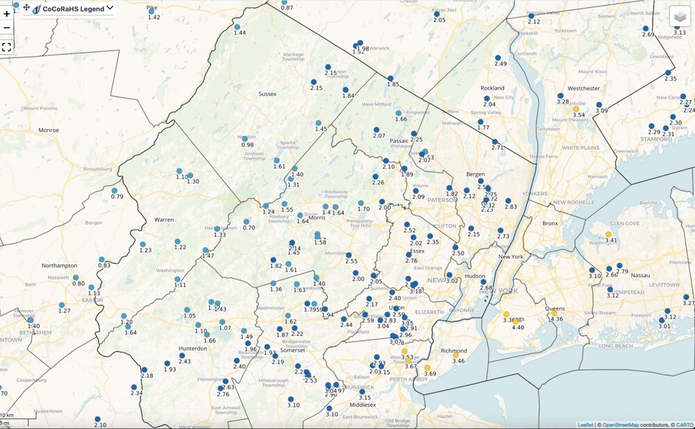
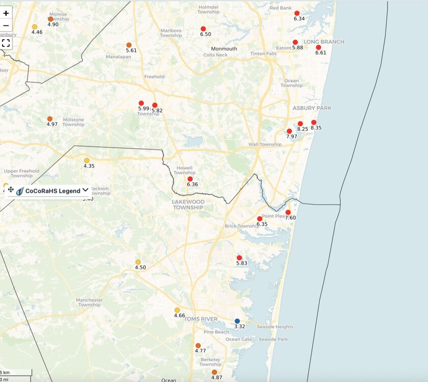
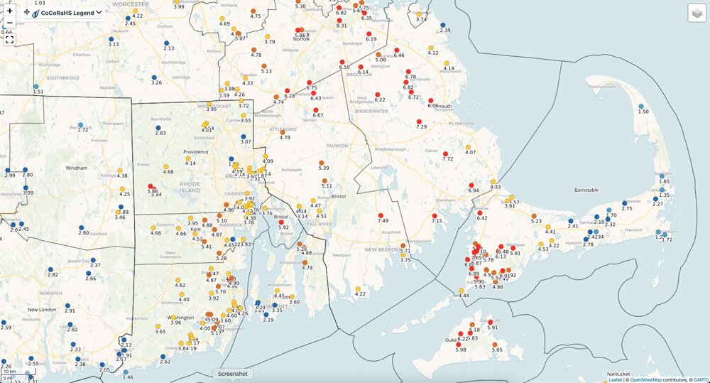
-
Storm Total: 1.26” in Lancaster, PA. .
-

2026-2027 Record-breaking El Nino
GaWx replied to Stormchaserchuck1's topic in Weather Forecasting and Discussion
Here in the SE, I prefer either EPAC or CPAC dominating it to the MC dominating because that would normally mean a much reduced influence of the SE ridge/colder overall. -
October Comes Early: Late September Multi-Hazard Hybrid Storm
Great Snow 1717 replied to WxWatcher007's topic in New England
That is being done far less now than at one time. There is nothing wrong with a forecaster make adjustments to their forecast. One of the major issues is the forecasters keep relying far too much on future radar as opposed to current radar. Often times the current radar looks nothing like the futurecast radar at that point..that creates doubt for me as the future cast radar moves forward in time. -
Strong Nor'Easter/Hybrid Storm Late September 2026
MANDA replied to Rjay's topic in New York City Metro
Mist and drizzle ended here about an hour ago. Three day event total: 1.55". Happy to have missed out on the bigger totals as well! M.T.D.: 5.46". Y.T.D.: 46.63". Making a run at 50"+ year. -
 1.5 storm total. Should slot pretty soon.
 -

2026-2027 Record-breaking El Nino
40/70 Benchmark replied to Stormchaserchuck1's topic in Weather Forecasting and Discussion
No doubt...the issue is whether it will be virtually all eastern Pacific, or some intervals of central Pacific influence will be at play. -
1.3 today, 3.2 total so far.
-

October Comes Early: Late September Multi-Hazard Hybrid Storm
WxWatcher007 replied to WxWatcher007's topic in New England
Yeah I’m not sure there’s a lot of trust in forecasts generally, but the storm being the lead story for a few days isn’t necessarily hype in my book. Now, if you’re not adjusting your forecast as you’re certainly heading toward a bust, that’s a whole different issue and problematic. Other than the clowns online using 925mb wind images and calling this tropical, I didn’t see a lot of hype, but we probably have different definitions of what hype is. Showing a legitimate rain and wind forecast map and saying we don’t usually get these in September doesn’t rise to the level for me. -
2026-2027 Record-breaking El Nino
GaWx replied to Stormchaserchuck1's topic in Weather Forecasting and Discussion
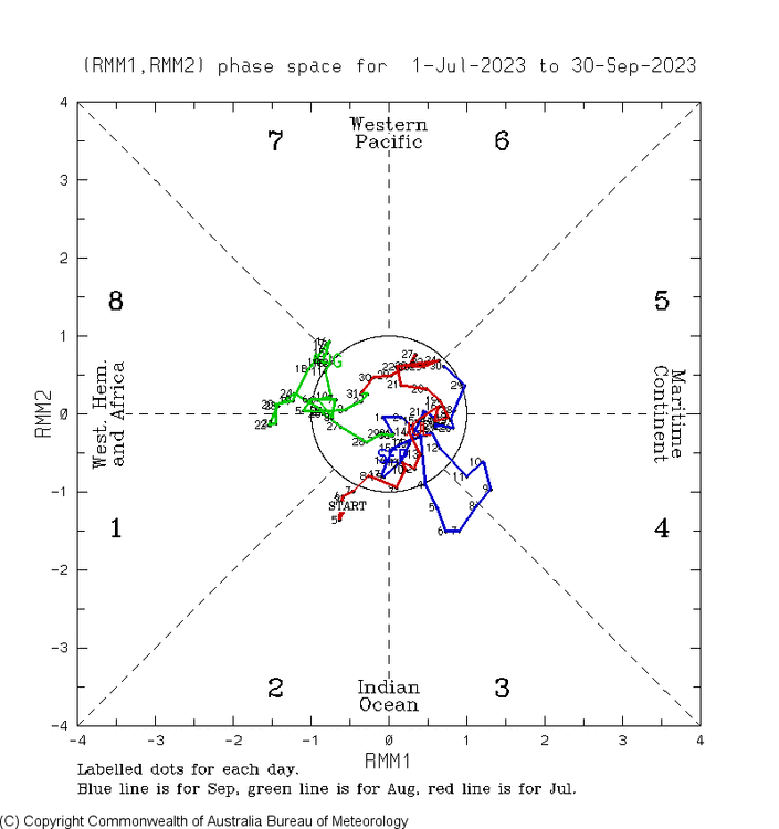
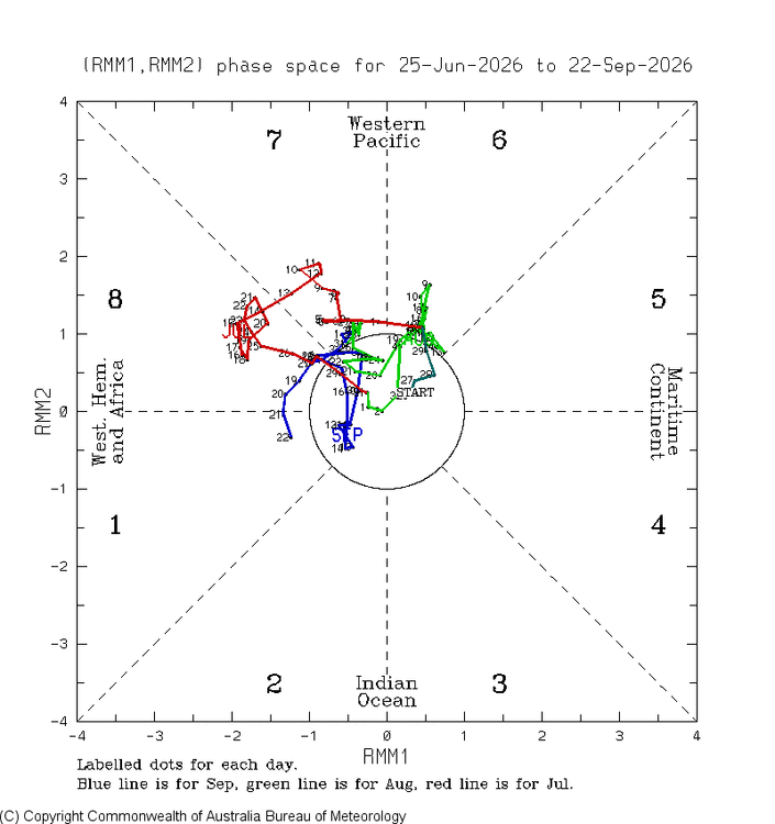
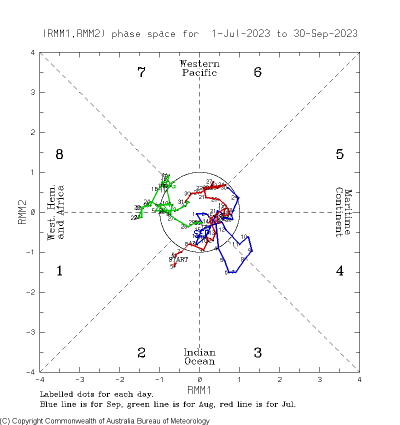
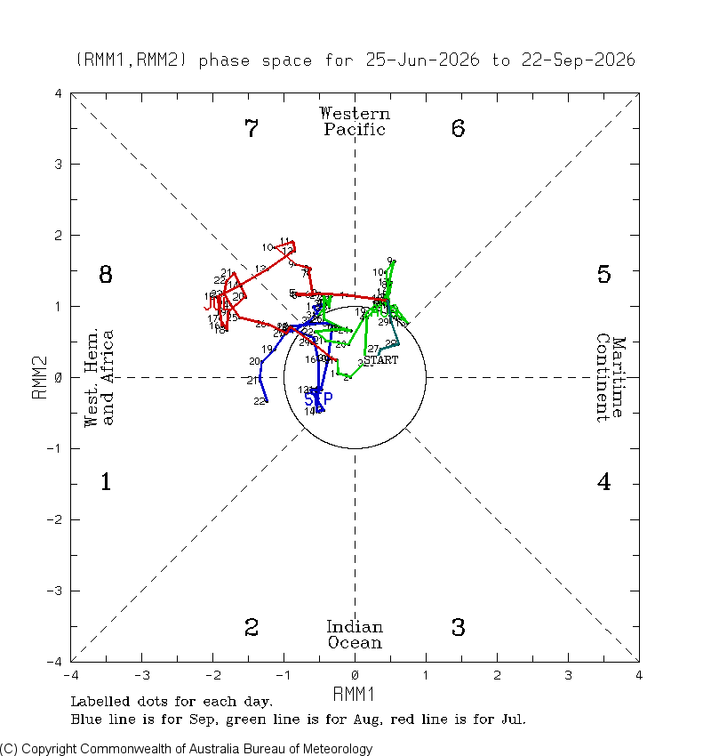
The Sep of 2026 MJO has been very different from that of Sep of 2023: Sep of 2023 (blue): all in MC/IO Sep of 2026: none in MC/IO