All Activity
- Past hour
-
Going to need a lot of it, Everything up here is way down.
-
NO
-
Yeah hopefully we get some rain up there.
-
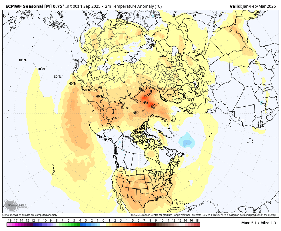
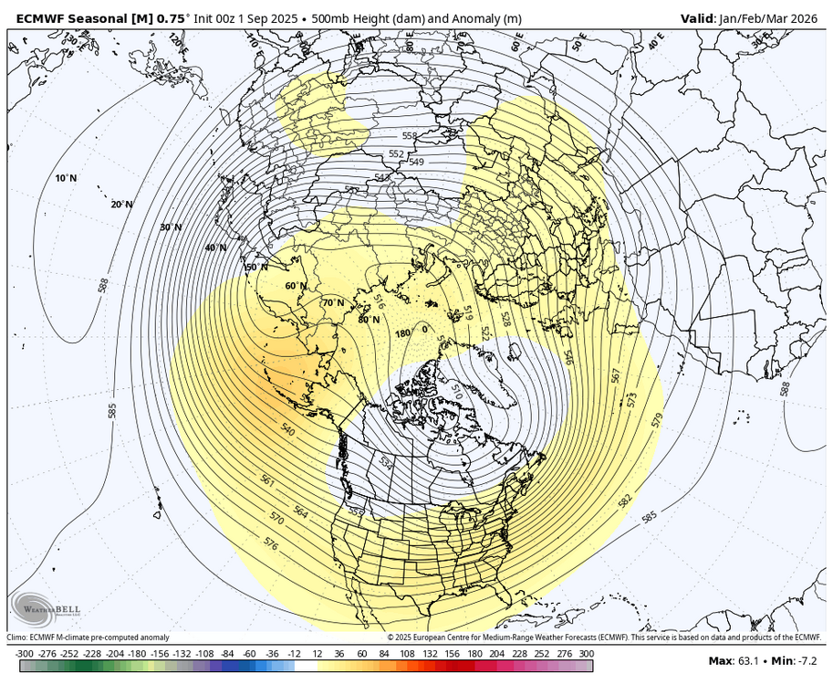
For what it is worth, below is Jan. to March on the latest WB EURO seasonal.


-
We usually go camping around that time, but one of the guys has a friend with a house on the Saco. May just rent it and go canoeing. We used to go there and on the Androscoggin, but haven't recently.
-
Dragging canoes is such fun, especially when they're loaded with duffle, food and drink. Learned all about that on Allagash Stream going to (and 4 days later, dragging back from) Allagash Lake.
-
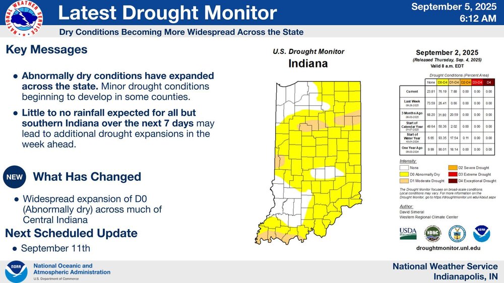
@Jackstraw It's pretty interesting how different weather can be over a relatively small area with similar terrain and elevation. While you eregetting pounded over and over earlier this summer, I'm in drought.
-
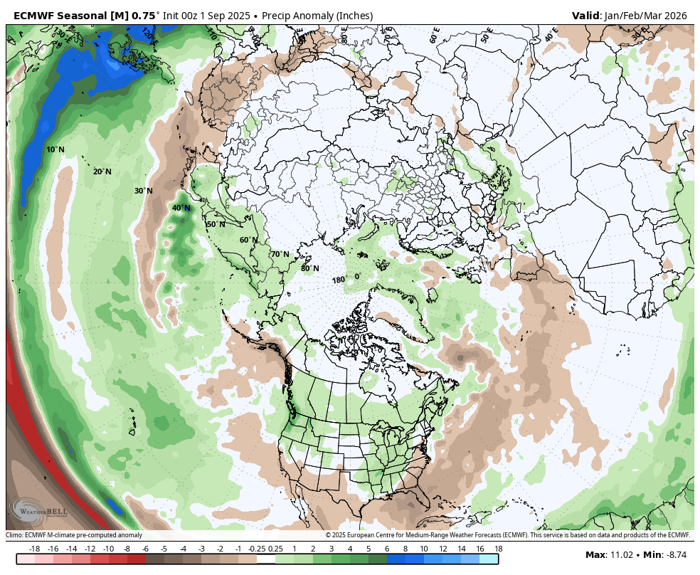
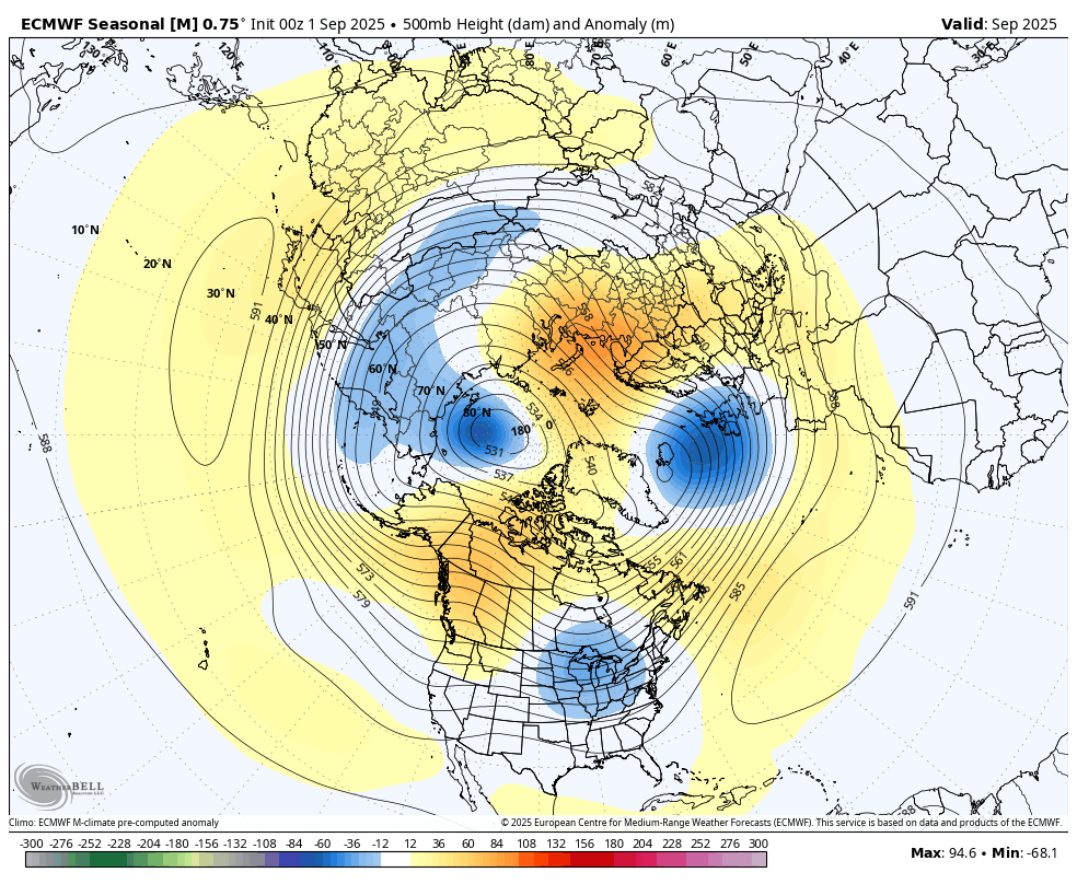
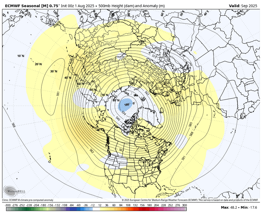
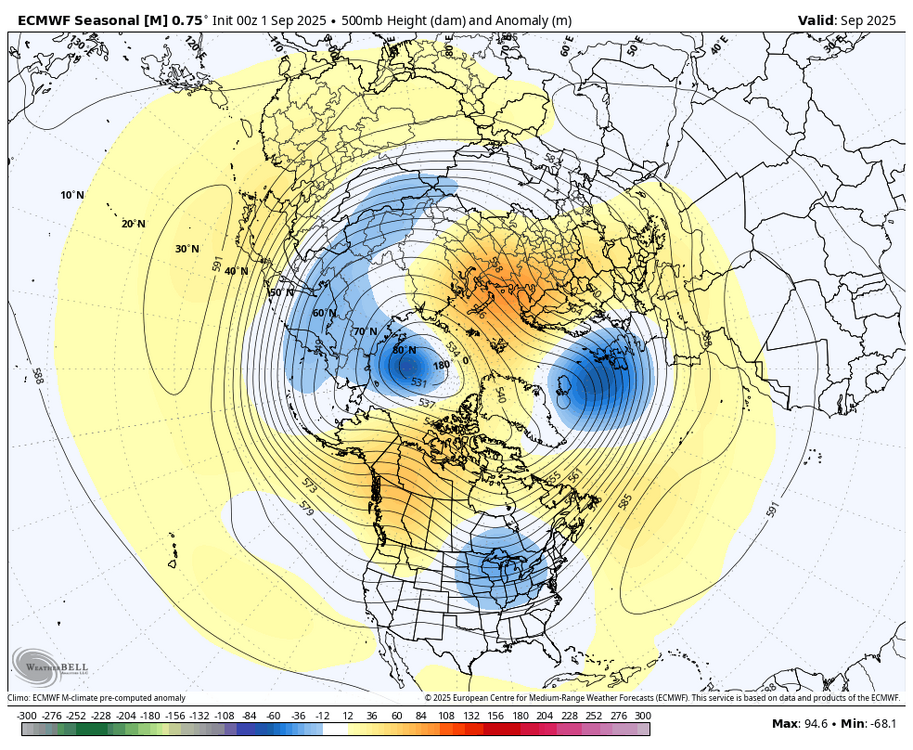
Take the WB Euro seasonal with a big grain of salt. Below is August 1 forecast for September compared to Sept. 1 forecast for September.
-
Fryeburg fair?
-
This is why you have to take anything past 240 , heck 200 hours with a grain of salt.
-
Looking to me like 91L might be DOA. Just looking to hostile in the path ahead of it. Shear and dry air abound. Kind of makes sense why models that had it developing kept in very small...like it found the sweet spot in a very hostile environment. Not expecting much from this now, IMO. PERHAPS, MAYBE some remnant of it eventually makes it to western Caribbean where conditions would be more favorable but looks like a long shot at them moment. We're kind of back where we started....looking for home brew stuff to pop.
-
https://x.com/AndyHazelton/status/1963994545768608055
-
yeah maybe we can start getting exciting weather again at least. the area is due for another pine buster
-
Is the Davis Vantage Vue still the weather station that you all most recommend? looking for a good weather station to gift my girlfriend for the farm. If I go with the Davis, do I need to spend extra for their monitor for it ? I would think not - but wanted to make sure the data from it is available on an app or the like. if not the Davis, are there comparable stations to it that I should be looking into? thanks! Aaron
-

September 2025 OBS-Discussion centered NYC subforum
Brasiluvsnow replied to wdrag's topic in New York City Metro
we have a yard sale both days this weekend ugh,,,,,,,,hoping that the rain holds off Saturday until 4 pm or later but we shall see,,,,,and Sunday looks like it starts out wet and again we shall see ,,,,,fingers crossed here -
Maybe we can Rocktober again. That was the best warm season type event since Bob I think.
-
See if we can tee up some more super structures today.. or just be an after thought relative to Thursday. I always like the Upper Plateau. Just a bit more upper level wind support per SPC text, plus the topography.
-
Deleted my post by accident.. but October you can get a second mini peak around mid month...however doesn't the pattern typically get more hostile by then with regards to westerlies? (up here)
-
Love it.
-

2025 Lawns & Gardens Thread. Making Lawns Great Again
jbenedet replied to Damage In Tolland's topic in New England
I had some really good success with what I put down two weeks ago. But you’re right, I may reseed today the areas I reseeded already that are coming in a little sparse. -
There will be water but it will be thick with sausages.
-
The entirety of next week looks nothing short of spectacular. After that, a bone extended to our warm weather lovers. Behind Saturday's cold front, winds will turn northwesterly and usher a much cooler, drier and less humid air mass into the mid-Atlantic States on Sunday. Skies should clear by the mid-to-late morning hours, and the rest of the day will turn out mostly sunny and pleasant with high temperatures in the mid 70s for most. A refreshing, 8-16 mph breeze out of Canada will cause dewpoints to tumble into the mid-to-upper 40s by late Sunday afternoon or evening, as well (see below). Needless to say, the weather during the second half of the weekend is shaping up to be absolutely spectacular and perfect for outdoor activities. Better yet, a sprawling high pressure system of Canadian origin will settle into the Commonwealth by Monday and then hold its ground across the Northeast and mid-Atlantic States through the rest of the week. That means Sunday's autumnal air mass will be sticking around from Monday-Friday and perhaps even through the following weekend. The large-scale subsidence, or sinking motion, associated with the high pressure system will thwart both clouds and precipitation, so skies should be mainly clear during most if not all of next week. Humidity will also remain very low with dewpoints no higher than the low-to-mid 50s. The combination of light winds, dry air and clear skies will promote efficient, radiational cooling at night, so low temperatures should bottom out in the chilly mid-to-upper 40s on 4 consecutive mornings (Monday-Thursday). They may hold in the low 50s in downtown York, Lancaster and Harrisburg each night, but that will still be perfect for sleeping with the windows wide open and turning off the A.C. Afternoons will be pleasantly cool with highs in the low-to-mid 70s from Monday-Wednesday and upper 70s to low 80s on Thursday. A weak cold front may slide southward through the Commonwealth on Thursday night, but there won't be a drop of rain associated with it. Instead, the front will simply bring a reinforcing shot of cooler air into the region next weekend with highs on Saturday and Sunday similar or identical to Monday-Wednesday. Don't be fooled by the persistently cool weather, though! There are signs that a significant warmup could occur during the third week of September with perhaps one last run at a 90-degree day or two. One thing's for sure.. after tomorrow, I have no idea when measurable rain will fall again. Then again, that's not abnormal in the absence of tropical activity during the month of September. Lather on the sunscreen and "enjoy the calm!"
-
Sounds like Sacoback River?
-
Supposed to have a mantown weekend in Fryeburg on the Saco later this month. Will there even be water in it?
-
0.06" overnight, A real soaker.