All Activity
- Past hour
-

January 2026 Medium/Long Range Discussion
NorthArlington101 replied to snowfan's topic in Mid Atlantic
I think I’m still more concerned about suppression so I think I agree with you. My scenarios are good snowstorm, whiff south and something light, and snow -> way too icy. No idea how I’d weigh each option but finding it hard to see is getting skunked -

Rise of the Machines: January 18-19 Winter Storm Obs Thread
CCHurricane replied to WxWatcher007's topic in New England
Last burst on Cape overlooking Nantucket sound ~ 9AM
-

Rise of the Machines: January 18-19 Winter Storm Obs Thread
ineedsnow replied to WxWatcher007's topic in New England
4.25 as of now but im guessing you got the extra 1/4 in the last hour -

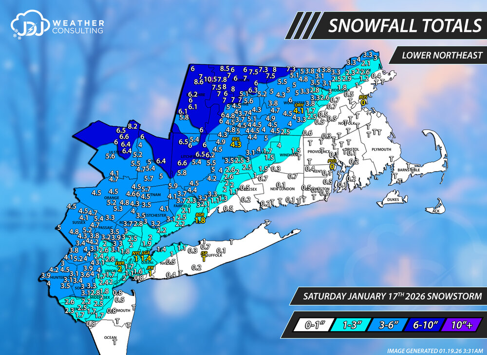
Storm potential January 17th-18th
The 4 Seasons replied to WeatherGeek2025's topic in New York City Metro
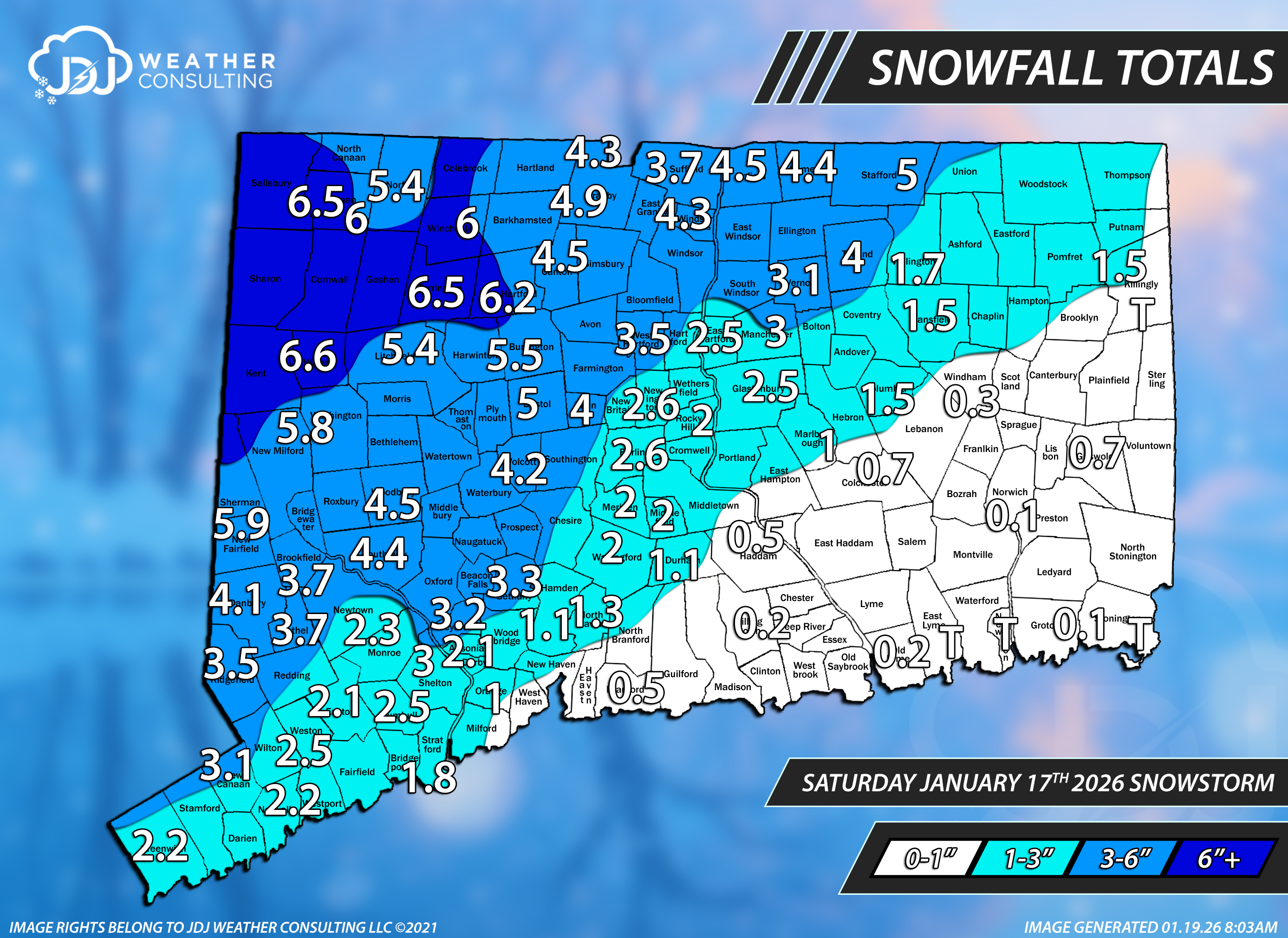
If anyone has any snowfall totals for Jan 18th ONLY, let me know, ill be doing maps for yesterdays system. These are the snowfall totals for the Jan 17th over performer. This only for the Saturday Jan 17th event Thanks to everyone who sent me reports, they were useful and i tried to include most of them if they could fit. You can always find all these maps along with CT and SNE here Lower Northeast Tri-State Area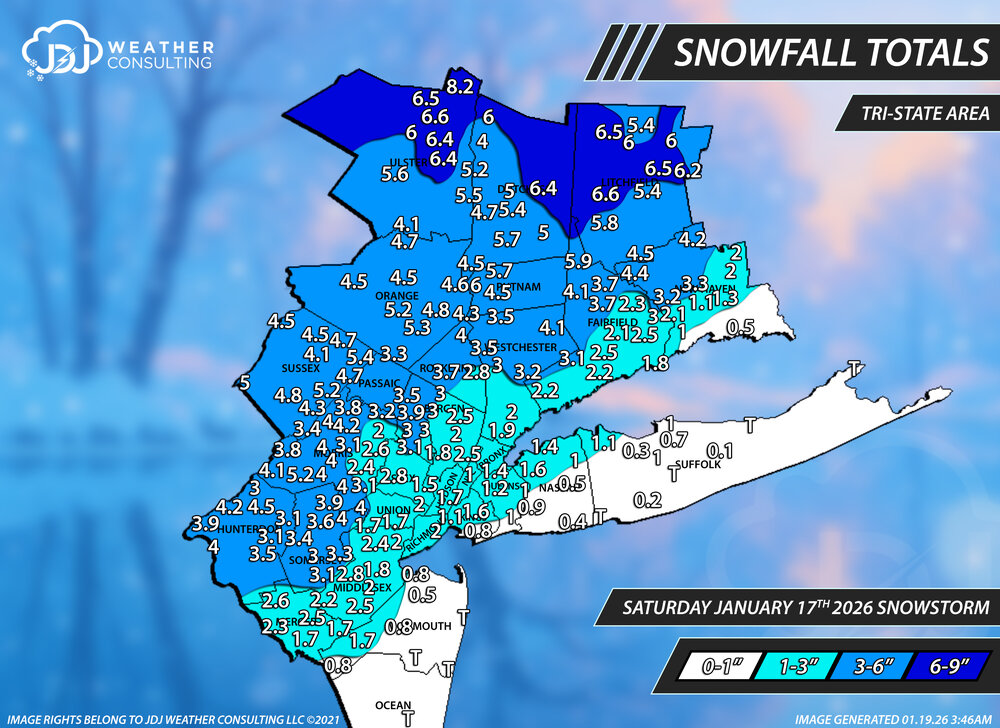

-
6z Euro was just a thing of beauty (except for the ice). How it unrolls the Baja low is almost perfect with how it has the shortwave moving through the Dakotas. There is going to be ice somewhere though. I think that is unavoidable with an overrunning setup.
-
Next 24-48 hours of model runs will be pivotal in determining what this looks like coming out. (i.e. one system vs. several smaller waves of overrunning moisture- Miller A/Miller B and what the orientation the incoming high will take on). Pretty confident a nice winter storm will scoot across, but in the mid-south there's always a chance the warm air across the gulf surges further north than modeled.
-

January 2026 Medium/Long Range Discussion
Scarlet Pimpernel replied to snowfan's topic in Mid Atlantic
I know, we've all been there, done that, have the T-shirt. Which is why I mentioned the GFS was showing that kind of scenario just the other day before it began suppressing everything, and everyone got freaked out at that. I still think currently, that's the least likely scenario...if anything I can see a snow to ice (or snow-ice-snow) outcome if this ends up going "too far" north in the end. -

Rise of the Machines: January 18-19 Winter Storm Obs Thread
HoarfrostHubb replied to WxWatcher007's topic in New England
Hubbardston MA. 4.0” Jan 18/19 -
Also, all of those happened during el ninos, with the 1966 and 2010 ones in strong el nino. Even the 1978 one had a borderline weak/moderate el nino.
-

January 2026 Short/Medium Range Thread
Weatheriscool replied to John1122's topic in Tennessee Valley
It is amazing that the Weather Channel literally has their forecasts pegged to the GFS; last night it had snow for my area Friday night Saturday and Saturday night, now, maybe an inch Friday night where before it was 1 - 3 for Friday night; 5 - 8 for Saturday, 1 - 3 for Saturday night -
Kinda just noise at this range though.
-

Rise of the Machines: January 18-19 Winter Storm Obs Thread
rimetree replied to WxWatcher007's topic in New England
Winding down. Measured 5"...not bad. -
If we do not get a MECS or two out of this pattern within the next 2 weeks there will be no explanation other than rotten luck.
-
@mappy our Norrisville dude has reported a 2-day total of 7.6"! Guy right across the border in Stewartstown has 4.7".
-
Rise of the Machines: January 18-19 Winter Storm Obs Thread
The 4 Seasons replied to WxWatcher007's topic in New England
Hey if anyone has reports for anywhere in SNE let me know you can pm or tag me. I also just finished all the maps for the January 17th event, they are in the thread, thanks. -
We have to snowfall total map yet?
-

Rise of the Machines: January 18-19 Winter Storm Obs Thread
dendrite replied to WxWatcher007's topic in New England
2.6”/0.17” here -
Sounds similar to Harbaugh
-

Storm potential January 17th-18th
wthrmn654 replied to WeatherGeek2025's topic in New York City Metro
Something to keep in mind and we do this every single time.... when snow events have borderline temps for nearly the entire event, on top of storms is a glancing blue, totals should be half of what models depict... on top of wet ground versus dry ground don't accumulate nearly as easy. But if heavy enough or banding, it can overcome those issues eventually. -
Another Coating of Snow Saturday - "It's all we Got"
The 4 Seasons replied to Sey-Mour Snow's topic in New England
Snowfall totals for the Jan 17th over performer. This only for the Saturday Jan 17th event. Jan 18th ill have done tomorrow. Thanks to everyone who sent me reports, they were useful and i tried to include most of them if they could fit. You can always find all these maps here Lower Northeast Southern New England Connecticut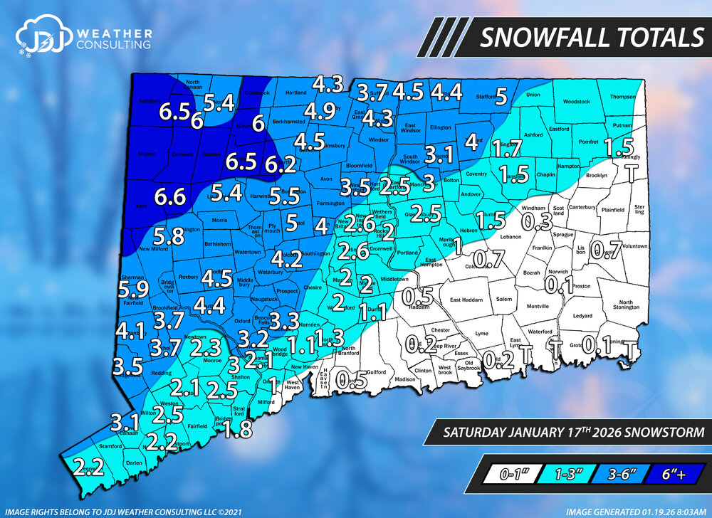

-
8-8 in the playoffs and this year there was no Ravens or Chiefs to deal with. Not sure if the 5 turnovers- 4 by his QB- can be blamed on him, but there have been some issues with him in the past as well.
-
i have a flight to san diego sunday for my girlfriends bday... of all days to have a potential winter storm lmao
-

Central PA Winter 25/26 Discussion and Obs
WmsptWx replied to MAG5035's topic in Upstate New York/Pennsylvania
This is my prediction unfortunately. -

Central PA Winter 25/26 Discussion and Obs
mahantango#1 replied to MAG5035's topic in Upstate New York/Pennsylvania
Or tomorrow too. -
I don't like the common thread there, more often a little too far south.