All Activity
- Past hour
-

Central PA Summer 2026 Discussion/Obs Thread
mahantango#1 replied to Voyager's topic in Upstate New York/Pennsylvania
-
The truth is usually a blend between INS and DIT.
-

Junorch obs and discussion 2026
Damage In Tolland replied to Damage In Tolland's topic in New England
Stein really has us now. Sucking the life out of everything thru the weekend -
Wow! Down here in the severe drought region we're watching it dry up on radar as it approaches. My area lost its hot hand from last July.
-
.41” that was not expected.
-
Cancelled my WaPo subscription yesterday, looking forward to watching you guys branch out and grow
-
Congrats NYC again.
-

2026-2027 Super El Nino
40/70 Benchmark replied to Stormchaserchuck1's topic in Weather Forecasting and Discussion
Yea, I have come to learn that RONI really isn't a great indicator of strength, but rather a measure of the degree to which other hemispheric forces (usually CC induced during the modern era) are competing with ENSO. Ultimately, the answer as to whether the ONI or RONI is of greater utility is more nuanced than the majority of those among weather circles perceive it as being, which is often the case. In reality they both seem to have some value. -
Miserable commute in. Saw two vehicles go off the road.. My garden appreciates the rain at least
-

Central PA Summer 2026 Discussion/Obs Thread
Voyager replied to Voyager's topic in Upstate New York/Pennsylvania
Not liking that Thursday outlook. I don't want hail. Been there, done that, had a damaged car that proved it when it happened. -
overnight d2
-
- Today
-
.20 this morning
-
Nice rain showers overnight and currently. Approaching .10. Grass will survive another week. edit: .21 at 7:08am
-
Howdy friend, glad to see you. Thanks for sharing this and glad it all worked out. Stop by more!
-
I witnessed nearly 150" fall last winter. I witnessed nearly 100" in 4 days on the Tug Hill. Another 16" in Harrington Delaware during the coastal storm in Feb and about 18" imby. My goal this winter is 300"+
-
Radar looks slightly interesting. Looks like some shower trying to make it into the lowlands. Looks mostly south. They look like slow movers.
-
Central PA Summer 2026 Discussion/Obs Thread
mahantango#1 replied to Voyager's topic in Upstate New York/Pennsylvania
-

2026-2027 Super El Nino
PhiEaglesfan712 replied to Stormchaserchuck1's topic in Weather Forecasting and Discussion
The 3 el ninos in the 82-92 period were all robust, though. The 88-89 la nina happened after the 2nd event. That's the only time really that robust el ninos were so close to each other. It will be interesting to see, after this el nino event, if the same pattern follows, and get such a strong la nina. -
Central PA Summer 2026 Discussion/Obs Thread
mahantango#1 replied to Voyager's topic in Upstate New York/Pennsylvania
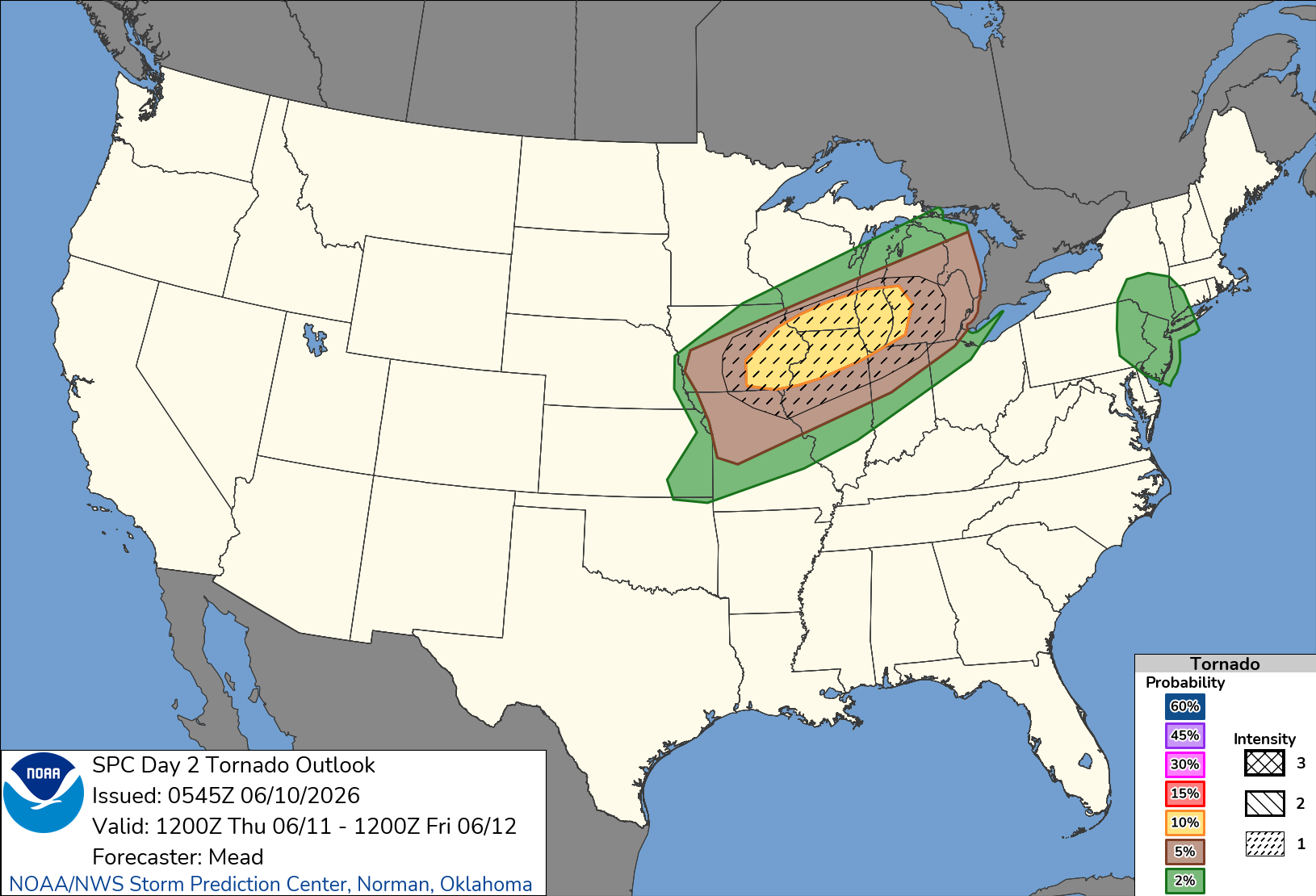
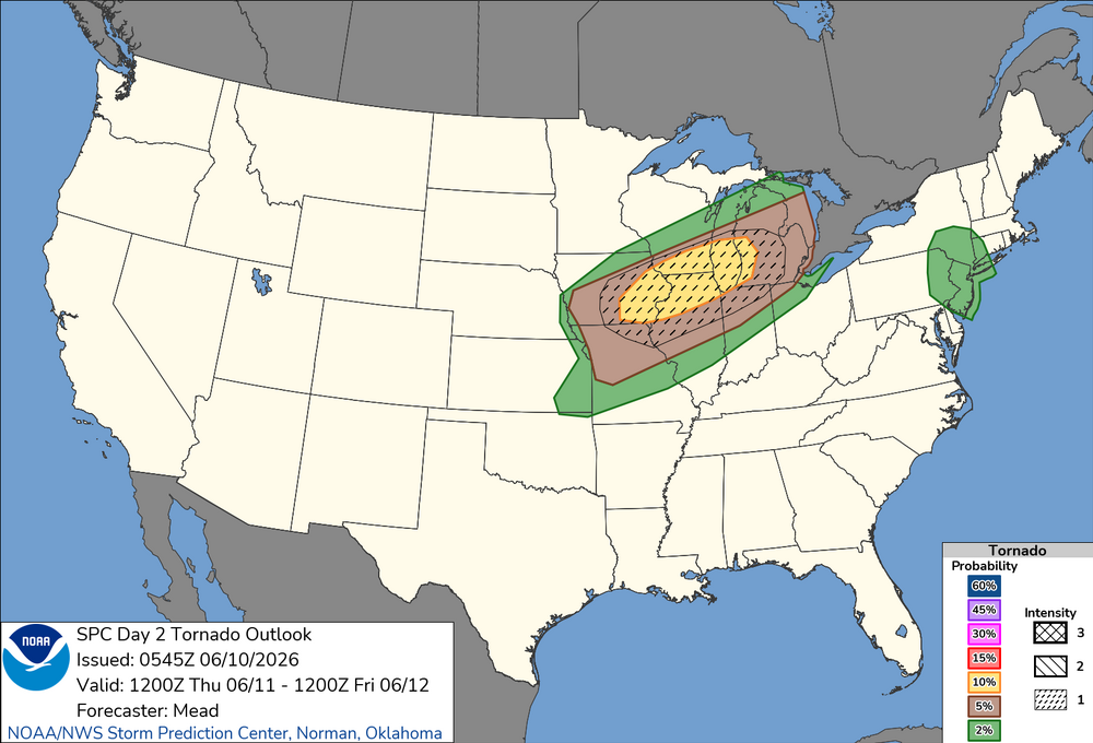
Hazardous Weather Outlook National Weather Service State College PA 348 AM EDT Wed Jun 10 2026 PAZ019-026>028-035-036-045-046-049>053-056>059-063>066-110800- Southern Centre-Huntingdon-Mifflin-Juniata-Fulton-Franklin- Southern Clinton-Southern Lycoming-Union-Snyder-Montour- Northumberland-Columbia-Perry-Dauphin-Schuylkill-Lebanon-Cumberland- Adams-York-Lancaster- 348 AM EDT Wed Jun 10 2026 This Hazardous Weather Outlook is for central Pennsylvania. .DAY ONE...Today and tonight. Strong to severe thunderstorms with gusty winds are possible this afternoon. .DAYS TWO THROUGH SEVEN...Thursday through Tuesday. Severe thunderstorms with damaging winds 60 mph or greater are possible Thursday and Friday afternoons. Heat and humidity will build through late week resulting in an increased risk for heat-related illnesses particularly Thursday and Friday afternoon. .SPOTTER INFORMATION STATEMENT... Spotters are encouraged to report significant hazardous weat -

2026-2027 Super El Nino
snowman19 replied to Stormchaserchuck1's topic in Weather Forecasting and Discussion
New JMA….FWIW -
No
-
Next week looks like ass.
-

Chester County PA - Analytical Battle of Actual vs. Altered Climate Data
chubbs replied to ChescoWx's topic in Climate Change
The deep dive in Chester County has made me very suspicious of older high temperature records in the US. Non-aspirated thermometers used back in the day are sensitive to shelter placement. It only takes one poorly sited station on one day to make a max temperature statistic misleading. Phoenixville in Chester County is a good example. Much hotter max temperatures than surrounding stations for 20 years in the 1930s and 40s. Well documented in this thread. As you show above, Martz's chart of nationwide high temperature records has the same problem. This whole thread is about using inconsistent data past vs present, to present misleading information. -
High of 88 yesterday, and picked up another 1/2" of rain in the afternoon in a T-Storm. Should be rain free the next couple of days, with T-storms returning for the weekend.