All Activity
- Past hour
-

E PA/NJ/DE Winter 2025-26 Obs/Discussion
Mikeymac5306 replied to LVblizzard's topic in Philadelphia Region
-

January 2026 regional war/obs/disco thread
40/70 Benchmark replied to Baroclinic Zone's topic in New England
Well timed pun on your put, as it was a bad commute this AM. -
That is like telling water to be dry.
-

E PA/NJ/DE Winter 2025-26 Obs/Discussion
Ralph Wiggum replied to LVblizzard's topic in Philadelphia Region
Should probably start a thread -
January 2026 regional war/obs/disco thread
40/70 Benchmark replied to Baroclinic Zone's topic in New England
If we don't get the SSW next month, absolutely. -
It shifted south from 0z, so quit complaining.
-
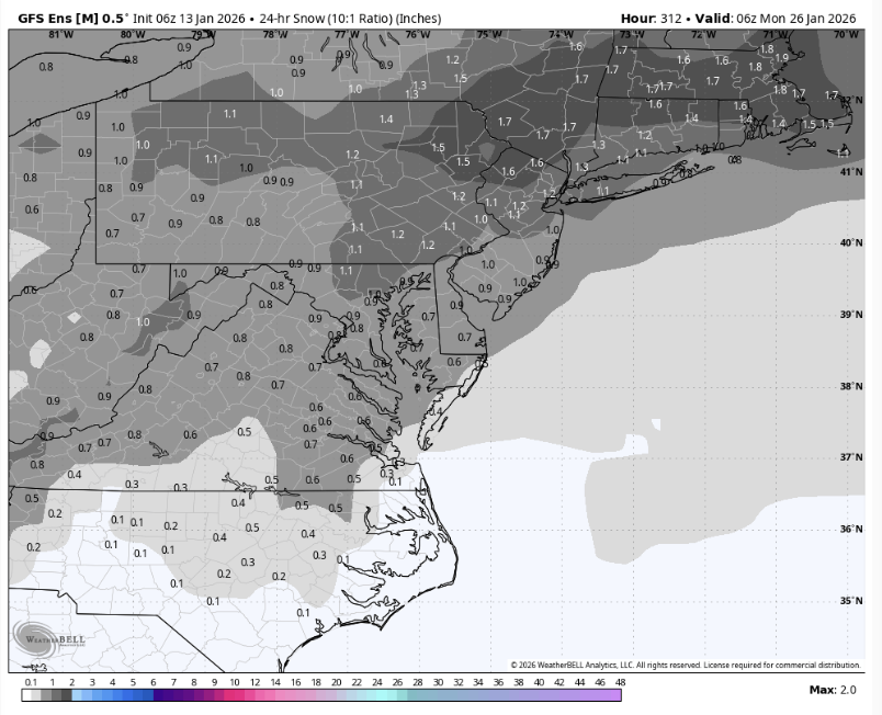
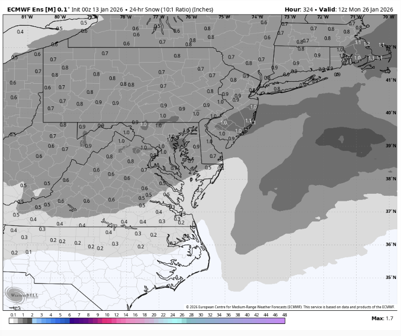
That's a massive signal considering it's 330 hours out.
-
Yea, someone was nice enough to drive her home (she has an in-law in my sister's basement), then my sister took her to the ED...did a Cat scan.
-
E PA/NJ/DE Winter 2025-26 Obs/Discussion
Mikeymac5306 replied to LVblizzard's topic in Philadelphia Region
Couple fantasy land storms brewing on 6z. Euro had it as well. -

January 2026 regional war/obs/disco thread
Sey-Mour Snow replied to Baroclinic Zone's topic in New England
Ya gfs has a wave on the 20th, euro closer with 18th.. -
Thats what I’m hoping for, a temporary transient -pna as an incoming wave undercuts across the sw towards here.
-

Central PA Winter 25/26 Discussion and Obs
Blizzard of 93 replied to MAG5035's topic in Upstate New York/Pennsylvania
Moving forward, the pattern looks active in week 2, with perhaps a chance of some moisture laden storms approaching from the south & west, instead of this never ending Clipper parade that we’ve had since mid December. There should be cold air around to tap into, so hopefully we can reel in something specific to track for later in the month. -
Central PA Winter 25/26 Discussion and Obs
Blizzard of 93 replied to MAG5035's topic in Upstate New York/Pennsylvania
Not what most of us were hoping for this week, especially with the way several model runs had been trending. Hopefully we at least see some snow in the air & maybe a coating for some. -

January 2026 regional war/obs/disco thread
Damage In Tolland replied to Baroclinic Zone's topic in New England
It’s gonna be a very early spring so some will need to -
Central PA Winter 25/26 Discussion and Obs
Blizzard of 93 replied to MAG5035's topic in Upstate New York/Pennsylvania
Wednesday Night A chance of rain before 4am, then a slight chance of snow. Mostly cloudy, with a low around 24. Southwest wind 5 to 14 mph becoming northwest after midnight. Winds could gust as high as 28 mph. Chance of precipitation is 50%. New snow accumulation of less than a half inch possible. -
Central PA Winter 25/26 Discussion and Obs
Blizzard of 93 replied to MAG5035's topic in Upstate New York/Pennsylvania
21 in Marysville for the low. -

January 2026 regional war/obs/disco thread
CoastalWx replied to Baroclinic Zone's topic in New England
Hopefully the boundary is over a police cruiser in Brooklyn. -
Not much cushion lol
-

Central PA Winter 25/26 Discussion and Obs
Mount Joy Snowman replied to MAG5035's topic in Upstate New York/Pennsylvania
Low of 30 at the house but 23 through the rurals on the car therm. -

Winter 2025-26 Medium/Long Range Discussion
A-L-E-K replied to michsnowfreak's topic in Lakes/Ohio Valley
slim pickings out there but euro selling some long duration duster potential well out in fantasy range and EPS looks decent during that window -
January 2026 regional war/obs/disco thread
CoastalWx replied to Baroclinic Zone's topic in New England
Hopefully the cold is overplayed and we ride closer to the boundary. Nothing worse than cold and dry. -
Some of them are gaining legs though. Thursday was always a long shot.
-

January 2026 regional war/obs/disco thread
WinterWolf replied to Baroclinic Zone's topic in New England
Bring the frigid cold. -
Winter 2025-26 Short Range Discussion
A-L-E-K replied to SchaumburgStormer's topic in Lakes/Ohio Valley
DAB+ on deck for thursday night -
My guess is that we will need at least one KU benchmark snowstorm of 12”+ in a wide enough area before the season is done for most of the major sites of EWR,NYC, LGA,JFK, and ISP to reach 25”+ on the season. But we are still getting no indication of a benchmark coastal snowstorm track in the near term. We haven’t had any seasons reach 25”+ since 1995-1996 without at least one 12”+ snowstorm. Since our snowy patterns since the mid 90s haven’t lasted long enough for a series of small to moderate events to get us to the 25”+ mark. So we needed to maximize our active snowy periods before we shifted out of the snowy intervals. But even if we do eventually get one 12”+ event, it’s not a guarantee that the 5 major sites will all reach 25”. This is what happened back in 2022 with the KU events favoring eastern sections like ISP and not EWR. During this record strong Northern Stream of the Pacific Jet era since 2018-2019, there have only been 4 snowstorms near the 40/70 benchmark with a least one spot in the OKX Zones reaching 12”+. This is why we are at 7 year record low for snowfall across the area. Our last benchmark KU was at the end of January 2022. From 2010 to 2018 there were 27 snowstorms closer to the benchmark with relatively good coverage of 12”+ across multiple sites often with numerous counties involved. The tracks which were west of the benchmark favored interior zones. Tracks near or to the east of the benchmark favored the coastal zones. Widespread 12”+ snowstorms since 2009-2010 with the maximum snowfall total in the OKX Zones. 2022 Jan 28-29….Islip….24.7 2021 Jan 31-Feb 2....Blomingdale, NJ.....26.1 2020 Dec 16-17 East Tremont, NY....12.4 2019 Mar 3-4...Monroe, CT....12.0 2018 Nov 15....Mount Hope, NY.......18.3 Mar 21-22...Patchogue, NY......20.1 Mar 13...Southampton,NY.....18.3 Mar 8....New Farfield, CT..........26.8 Mar 2...Monroe, NY.................14.0 Jan 4...Islip, NY.......................15.8 2017 Mar 14...Montgomery, NY.......23.5 Feb 9...Selden, NY...................16.0 Jan 7...Orient, NY....................12.5 2016 Feb 5...Setauket, NY................12.0 Jan 23..JFK,NY.........................30.5 2015 Feb 2..New Faifield, CT............12.0 Jan 26-27....Orient,NY.............28.5 2014 Feb 13-14...Roselle, NJ............16.7 Jan 21-22....Centerreach,NY....14.0 Jan 2-3......Lindenhurst, NY.....12.5 2013 Mar 8....Harriman,NY..............15.0 Feb 8....Upton, NY..................30.9 2012 Nov 7-8.....Monroe, CT..........13.5 Jan 21......North Haven, CT....12.0 2011 Oct 29.....Harriman, NY.........16.0 Jan 26-27...NYC................... 19.0 Jan 11-12.......Meriden, CT....29.0 2010 Feb 25-26...Mount Hope, NY...27.5 Dec 26........Elizabeth, NJ........31.8 Feb. 10.....Sound Beach, NY....16.2 2009 Dec 19-20....Upton, NY..........26.3


