All Activity
- Past hour
-
URGENT - WEATHER MESSAGE National Weather Service Baltimore MD/Washington DC 815 PM EDT Sun Sep 7 2025 MDZ509-510-VAZ503-WVZ501-505-080800- /O.NEW.KLWX.FR.Y.0007.250908T0600Z-250908T1200Z/ Western Garrett-Eastern Garrett-Western Highland-Western Grant- Western Pendleton- 815 PM EDT Sun Sep 7 2025 ...FROST ADVISORY IN EFFECT FROM 2 AM TO 8 AM EDT MONDAY... * WHAT...Temperatures as low as 34 will result in frost formation. * WHERE...In Maryland, Eastern Garrett and Western Garrett Counties. In Virginia, Western Highland County. In West Virginia, Western Grant and Western Pendleton Counties. * WHEN...From 2 AM to 8 AM EDT Monday. * IMPACTS...Frost could harm sensitive outdoor vegetation. Sensitive outdoor plants may be killed if left uncovered.
-
Yeah. There’s a couple areas around here where there’s some groups of trees that have a decent amount of color. There’s always some trees with color at this time of year but I feel like it’s been awhile since there’s been this much color already in early September.
-
My thought is that he did pretty well with boldly saying early on the Carolinas would be impacted by Erin. How has he done otherwise as of Sept 7th? Had he made other bold calls?
-
Another .63" today....1.85" 2 day total, 1.96" 3 day.
-
Open windows tonight. Sent from my SM-G970U1 using Tapatalk
-
0.03" here yesterday through early this morning.
-
1.37", about .8 of that coming in a very short amount of time earlier..then a nice steady soaking through the evening
-

September 2025 OBS-Discussion centered NYC subforum
psv88 replied to wdrag's topic in New York City Metro
2.25” storm total here. Should keep the grass green into October -

2025 Atlantic Hurricane Season
BarryStantonGBP replied to BarryStantonGBP's topic in Tropical Headquarters
Yes lad, respect Gazza innit! What are your thoughts? -
-
It seems to be really early for frost even up that way.
-
URGENT - WEATHER MESSAGE National Weather Service State College PA 112 PM EDT Sun Sep 7 2025 PAZ012-018-019-024-037-042-045-081200- /O.NEW.KCTP.FR.Y.0007.250908T0600Z-250908T1200Z/ Northern Clinton-Northern Centre-Southern Centre-Cambria-Tioga- Sullivan-Southern Clinton- Including the cities of Mansfield, Lock Haven, Laporte, Wellsboro, State College, Philipsburg, Renovo, and Johnstown 112 PM EDT Sun Sep 7 2025 ...FROST ADVISORY IN EFFECT FROM 2 AM TO 8 AM EDT MONDAY... * WHAT...Temperatures as low as 35 will result in frost formation. * WHERE...Cambria, Northern Centre, Northern Clinton, Southern Centre, Southern Clinton, Sullivan, and Tioga Counties. * WHEN...Early Monday morning. * IMPACTS...Frost could harm sensitive outdoor vegetation. Sensitive outdoor plants may be killed if left uncovered.
-
Is this Gary Lezak stuff?
-
Late month warm up seems to be a possiblity. Not unusual in Septembers that feature cool shots such as this month based on medium range modeling.
-
Had a high today of 68 with a low of 54 this morning but temps are absolutely dropping like a rock this evening. Current temp already down to 54.
-
An absolute beautiful day at the Mountain State Fair. Sent from my SM-G998U using Tapatalk


- Today
-
2025 Atlantic Hurricane Season
BarryStantonGBP replied to BarryStantonGBP's topic in Tropical Headquarters
Told you bruv. I also had these as return dates so you can see where I'm coming from innit Next return date I have is for 16th September-ish for a weaker MDR storm and 25th September for a more intense Gulf storm. In fact GDM and a few ensembles are hinting at the MDR storm right now The CAGs are difficult to detect. for some reason ENS keep thinking it might be an EPAC/baja storm... because things seem to favour the EPAC more rn. but watch it flip dramatically I'm telling you innit I've got about 4-5 return dates for October as well -

September 2025 OBS-Discussion centered NYC subforum
donsutherland1 replied to wdrag's topic in New York City Metro
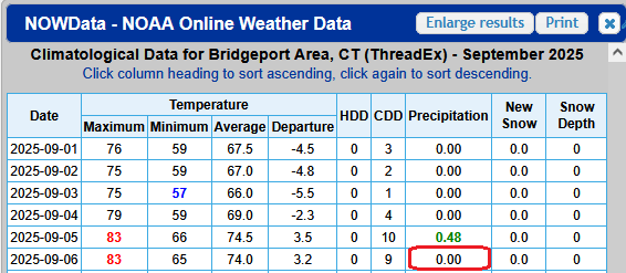
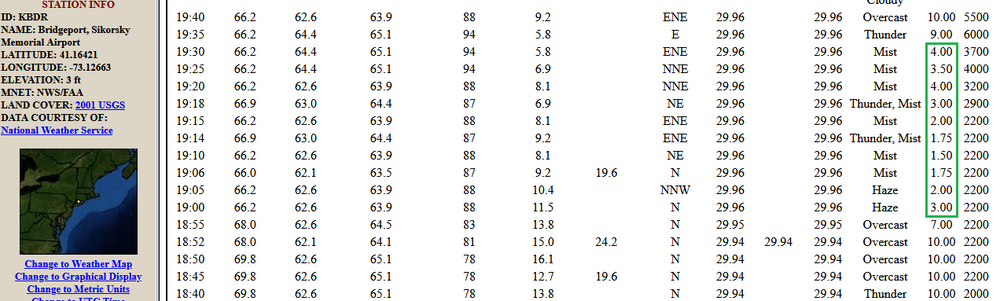
FYI, the NWS has added the rainfall amounts that were missing for both August and yesterday for Bridgeport. The region benefits from its high quality and responsive NWS office.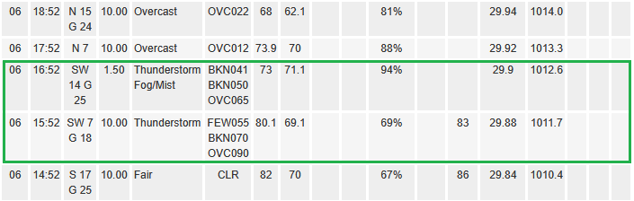
- Yesterday
-
I can’t make that detailed a call, but that’s the start of prime W Caribbean/Gulf season climowise.
-
Measurable precip the last 3 days which is welcome, though I realized my Davis was clogged so not sure what I actually got here. Nice pink hued skies this evening as the clouds depart. 59/58
-
87 for a high today, humidity dropped through out the day. Beautiful day
-
Yeah, but I bet the ACE number is wicked high, great season so far
-
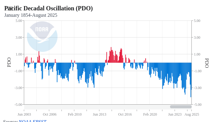
This is a good visual showing just how hostile the pdo has been since 2017. It's only one piece of the puzzle and no single index drives "it all" but it's also no coincidence that the last time it was friendly (2014-16) we had one of our best stretches of consecutive winters. In enso neutral and nina winters we need a good alignment in the Pac or it gets pretty hard to get things right around here with cold and winter wx. If things are going to work this winter a -EPO will be really important. Generally speaking, -EPOs don't come easy if at all when the PDO is strongly negative.
-
Dare I say go bills tonight?
-
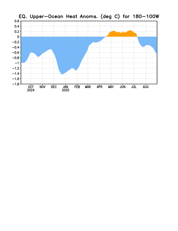
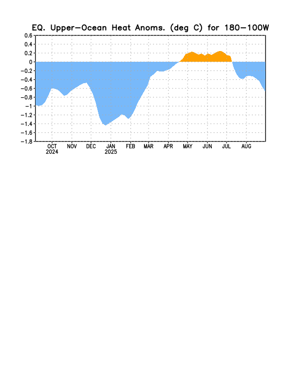
The OHC has recently been cooling substantially after the prior rather steady period: @snowman19you’ll probably like this trend