All Activity
- Past hour
-
December 11th - 12th clipper potential
Kentucky replied to Holston_River_Rambler's topic in Tennessee Valley
29 and light snow -

December 2025 regional war/obs/disco thread
ScituateWX replied to Torch Tiger's topic in New England
It’s weather having a little one now and another on the way all I do now is keep an eye on it and not get emotionally invested. As one who plows snow it would be great to get snow but it is what it is and there are plenty of other positives with each day. -

December 2025 regional war/obs/disco thread
Sey-Mour Snow replied to Torch Tiger's topic in New England
Yes agree, especially south of 84. -
For the past few days, meso models and even globals advertised a finger-like lake effect snow band getting into NNJ this evening. And it has verified as advertised. Count me as impressed.
-
LMAO. Hawaiian weather in dca for Xmas. Late dad born in Hawaii, we always said mele kalikimaka first thing Xmas morning after we got up. I'll never forget that...
-

Winter 2025-26 Medium/Long Range Discussion
Powerball replied to michsnowfreak's topic in Lakes/Ohio Valley

-

December 2025 regional war/obs/disco thread
WxWatcher007 replied to Torch Tiger's topic in New England
It seems so tenuous with the guidance split, but then I think we’re in a scenario where mid level magic would bring a solid coating at least even if we do get a messenger shuffle. Totally get the angst in MA but for CT I think this looks…I dare say decent. As long as folks aren’t thinking we’re going to trend to a warning event. Which I know nobody here does lol. -
Just reading the latest. Brutal. As if we are all new here.
-
Yet another snowy evening out there. Everything's dusted up pretty good - maybe 1/4". From radar I suspect parts of western or northern Morris county have accumulated 1/2" - 1" this evening. These minor events help soothe the snowstorm deprivation angst.
-
Easy is not a word I've used frequently the last few years... I do like the tight low/mid level thermal gradient, and know if we can force enough convergence into that gradient, it would produce a decent snowfall? But I need to see consistent guidance trending that way. If I do, I'll move from a general 1 to 2 to a call to a 2-to-4-inch forecast, biased east and southeast. I'll be working from the Cape this weekend, so I expect to see snow even if CT underperforms.
-

December 11th - 12th clipper potential
Holston_River_Rambler replied to Holston_River_Rambler's topic in Tennessee Valley
Snowing lightly here now -
The best are those in SNE that are actually positive. Every year since 2022. While I sit back like the fat kid on Stand By Me watching them puke all over each other in the pie eating contest.
-
December 11th - 12th clipper potential
Holston_River_Rambler replied to Holston_River_Rambler's topic in Tennessee Valley
Yeah it looks like we’re saturating a little quicker than some upstream areas based on MRX radar. -
 I will be in attendance
 -
If I am not mistaken, I believe MJO phase 5 is the worst for cold and wintry weather
-
December 2025 regional war/obs/disco thread
Baroclinic Zone replied to Torch Tiger's topic in New England
Split open and melt -

December 11th - 12th clipper potential
John1122 replied to Holston_River_Rambler's topic in Tennessee Valley
Sort of steady light snow now. Took probably 30-40 minutes of returns to get flakes down here. -

Minor snow possible sunday 12/14/25
Krs4Lfe replied to WeatherGeek2025's topic in New York City Metro
Hopefully New York City can sneak in 4 inches of snow by the end of the month although that is looking increasingly unlikely especially with the big warm-up coming after the 20th. Statistics don’t lie and Decembers that usually feature at least 4 inches of snow in New York City have a high chance of producing average or above average snowfall for the rest of the season. Central Parks measuring has been consistently terrible over the past few years even more so then it had been in the past so I wouldn’t be surprised if they barely record an inch from the snow that is coming on Sunday. -
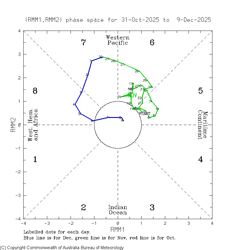
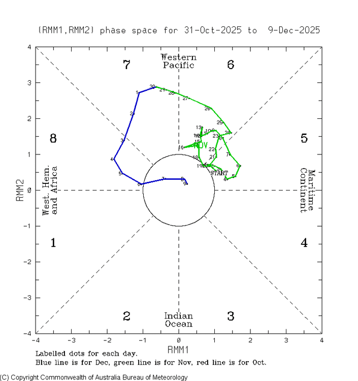
Check this out. The official Australian RMM MJO for Dec 9th has already been released: after the Dec 3-7 phase 8 went surprisingly (to me) to Dec 8th’s very weak phase 6, Dec 9th comes in at very weak phase 5! Holy smokes! I still think it may retreat back to phase 8 later, but that remains to be seen:
-

12/12: The little Friday clipper that could? Or won't.
WesternFringe replied to dailylurker's topic in Mid Atlantic
Right when the storm started to disappear on the majority of guidance this afternoon is when the national weather service upped their forecast for my area to 1 to 3 inches from less than 1/2 of an inch. I’m super confused. They must have information I don’t have access to. -
Yeah good luck with that
-
Trend line baby. Toes in the water. Weenie in the sand. No need to worry, I got Wolfie in my hand…life is good today.
-

December 2025 regional war/obs/disco thread
WinterWolf replied to Torch Tiger's topic in New England
The warmth is shrinking..as we knew it would. It’s been the trend all autumn. -
I love the Euro. No matter what. But, Mid Atlantic is gonna get NAM'MED and shellacked.
-
December 25th is right around the corner