All Activity
- Past hour
-
 I was leaving the jersey shore and getting gas in Brick when the storms rolled thru. Lightning struck directly across the street and everyone lost power….after 3 gallons
 -
Didn't get much fanfare but yesterday was the hottest day of the month in Boston.
-
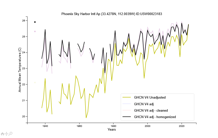
Not sure about Phoenix as a whole. But the heat island effect looks saturated at the Sky Harbor airport which isn't far from downtown. Actual and adjusted temperatures have warmed at the same rate since 1980. This means that the airport is warming at the same rate as regional sites outside of the Phoenix heat island. Before 1980 there is evidence of heat island warming at the airport (or some other site specific issue).
-
I just closed a couple.
-
-

Hurricane Erin: 130 MPH - 942mb - NW @ 12
Bxstormwatcher360 replied to BarryStantonGBP's topic in Tropical Headquarters
Westward'ho. The track keeps ticking wnw. It's going to be close for obx i believe,she's making her own way tbh,a total monster of a storm currently. -
49.4° 30s up yonder
-

E PA/NJ/DE Summer 2025 Obs/Discussion
Nodriveslow replied to Hurricane Agnes's topic in Philadelphia Region
Had 1.90" in the COCORAHS gauge this morning. -
Down to 61F in E CT, only 0.05” here, not nearly enough. The good news is the air is off for most of the week!
-
45 outside, 50 at the kitchen island- I probably shouldn't have left all the windows open last night
-

E PA/NJ/DE Summer 2025 Obs/Discussion
BBasile replied to Hurricane Agnes's topic in Philadelphia Region
Picked up 0.87" of rain last night. Well done, atmosphere. -
Trade winds/EWBs look to strengthen significantly in the coming couple of weeks which will enhance a more La Niña and -AAM regime as we go into met fall
- Today
-
Definitely cool out there and breezy.
-
Orioles shut out Astros 2 out of 3 games... I never saw that coming! Lol
-

Hurricane Erin: 130 MPH - 942mb - NW @ 12
Floydbuster replied to BarryStantonGBP's topic in Tropical Headquarters
This is way more intense than Georges was, especially after Georges interacted with land throughout the Caribbean. In fact, if I recall, Georges sort of underperformed in the Gulf of Mexico. -

Hurricane Erin: 130 MPH - 942mb - NW @ 12
LongBeachSurfFreak replied to BarryStantonGBP's topic in Tropical Headquarters
30c water temps working their magic. We see it in the gulf and west pac. Here we go with the Atlantic version. -

Hurricane Erin: 130 MPH - 942mb - NW @ 12
BarryStantonGBP replied to BarryStantonGBP's topic in Tropical Headquarters
How did Georges 1998 compare -
Hurricane Erin: 130 MPH - 942mb - NW @ 12
Floydbuster replied to BarryStantonGBP's topic in Tropical Headquarters
Good grief Erin is primed to explode. -

Hurricane Erin: 130 MPH - 942mb - NW @ 12
Windspeed replied to BarryStantonGBP's topic in Tropical Headquarters
Yeah, I'm starting to feel like I may eat my words that Erin would never be able to regain Category 5 intensity. It may still not, depending on how much it needs to bomb a pressure drop to contract that RMW enough to get there again. But deep convection is really circumventing the eyewall at present, and at this rate, all the old cloud debris in the eye should dissipate at some point this morning. If we get a warm symmetrical eye during the daylight hours today, it may well exceed my expectations. We're going to have some interesting recon flights today. -

Hurricane Erin: 130 MPH - 942mb - NW @ 12
WxWatcher007 replied to BarryStantonGBP's topic in Tropical Headquarters
The appearance has improved dramatically as the deep convection is now fully wrapped. -
 Isolated shower on the north shore just dropped a half inch of rain here in 10 minutes. Reminiscent of a year ago but that lasted 3 hours.
 -
Does Roy get to sing for the end of summer too?
-

Hurricane Erin: 130 MPH - 942mb - NW @ 12
GaWx replied to BarryStantonGBP's topic in Tropical Headquarters
^Followup to text: Here’s the 0Z UKMET 84 hour map at closest approach to NC, only 135 miles while at 943 mb: sorry about the blur but a screenshot was only way I could save this (not yet out on WxBell):
-
Hurricane Erin: 130 MPH - 942mb - NW @ 12
GaWx replied to BarryStantonGBP's topic in Tropical Headquarters
0Z UKMET: furthest NW and strongest run yet while SE of NC at closest point (942 mb!). It is then a mere 135 miles SE of Hatteras as of 8AM Thu!HURRICANE ERIN ANALYSED POSITION : 22.0N 68.9WATCF IDENTIFIER : AL052025LEAD CENTRAL MAXIMUM WINDVERIFYING TIME TIME POSITION PRESSURE (MB) SPEED (KNOTS)-------------- ---- -------- ------------- -------------0000UTC 18.08.2025 0 22.0N 68.9W 938 1011200UTC 18.08.2025 12 23.0N 70.7W 949 960000UTC 19.08.2025 24 23.9N 72.0W 968 691200UTC 19.08.2025 36 25.3N 72.8W 969 710000UTC 20.08.2025 48 27.2N 73.8W 964 601200UTC 20.08.2025 60 29.2N 74.3W 957 810000UTC 21.08.2025 72 31.6N 74.8W 949 911200UTC 21.08.2025 84 33.6N 73.8W 942 820000UTC 22.08.2025 96 35.4N 71.9W 943 691200UTC 22.08.2025 108 36.1N 69.7W 942 700000UTC 23.08.2025 120 36.9N 67.7W 947 631200UTC 23.08.2025 132 37.9N 66.1W 951 660000UTC 24.08.2025 144 39.3N 64.3W 955 581200UTC 24.08.2025 156 40.9N 62.4W 956 550000UTC 25.08.2025 168 42.8N 58.8W 964 52 -
lol yeah same here, fires all over Ennis now. You're welcome