All Activity
- Past hour
-
Looks like it may have indeed been a tornado according to Ken Weathers.
-
Nam is basically totally dry tomorrow (probably wrong)
-
Sorry.. its so dry that there is a 23% chance that the potomac basin reservoirs will be tapped within the next 6 months. Seeing how this area feeds the nation that's good news
-
Yea this stuff sucks. I have some tiling to do but the kids are gonna be bored all weekend. Maybe we'll check out the Oakland railroad museum.
-
The hell are you talking about?
-
Been getting hammered over the last 2 hours. I kinda forgot what a good soaking rain felt/sounded like
-
51 degrees and rain on May 22nd... unbelievable
-
Interesting.. my grass is greener than it's been in years. Surely the reservoirs are dry with such a bombastic analysis.. oh wait, no.. they aren't even close to being tapped
-
Really beneficial rain and since we are near the head of the Potomac in MD this benefits the entire basin. Perhaps we will remember this weekend as the true beginning of the pattern change toward El Niño. Approaching 2 inches so far. (Pouring right now!)
-
.86” with a lot more coming in. 1.88” for the event so far.
-
Imagine if this was a snow event.
- Today
-
This is likely the storm that spawned the damage. This view is reportedly from about 15 miles south of the damage area and the storm was moving north. https://www.facebook.com/share/v/1Fb2YSrvcB/
-
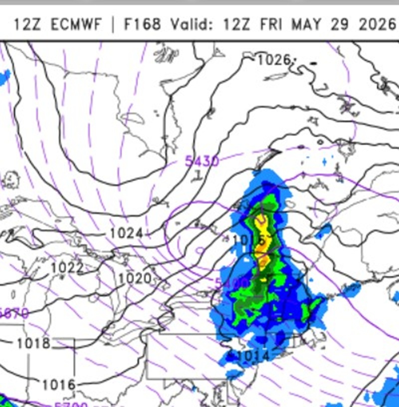
Accumulating snow in June outside of MWN or AOA 5000 ft is very rare in New England. Look at the 168 hr 12z ECMWF. Nice cold cut-off at 500 dropping SSE. That how you do it this late. The most Xtreme 500 case was May 9-10, 1977. You could track the upper low from northern Hudson's Bay all the way to S of LI, where it became a massive 5 contour 500 cut off (going by every 6 dm). Of course, it would take an truly extraordinary set up for Scott to see flakes in June here! The June 6, 1816 S+ in NNE had the benefit of the volcanic cooling combined w/ a strong sun Maunder minimum.

-
18z in general seemed pretty wet to me, looks like 2”+ for most especially I-80 and S on the RGEM, NAM. In any event looks like a nasty 48hr period upcoming.
-
Damage from a storm this evening just east of here. Fellow that shared the photos said it was a tornado but I'd guess it was a downburst.
-
Light rain all day and now pouring here again. I'm well over 3" for this event now. I may have to start measuring every 6 hours to avoid rain compaction.
-
Haha, I'm back in CT now but life has definitely returned up there. SLK was a ghost town in March and April lol. Now there are boats on the water, hikers on the trails, and restaurants reopening.
-
You think 1,000ft where his point and click is probably from sees 10 days of 75-85? I’m guessing 1,000ft is 67-79F starting Monday like that forecast. Doesn't seem unreasonable.
-
A beautiful rainy evening.
-
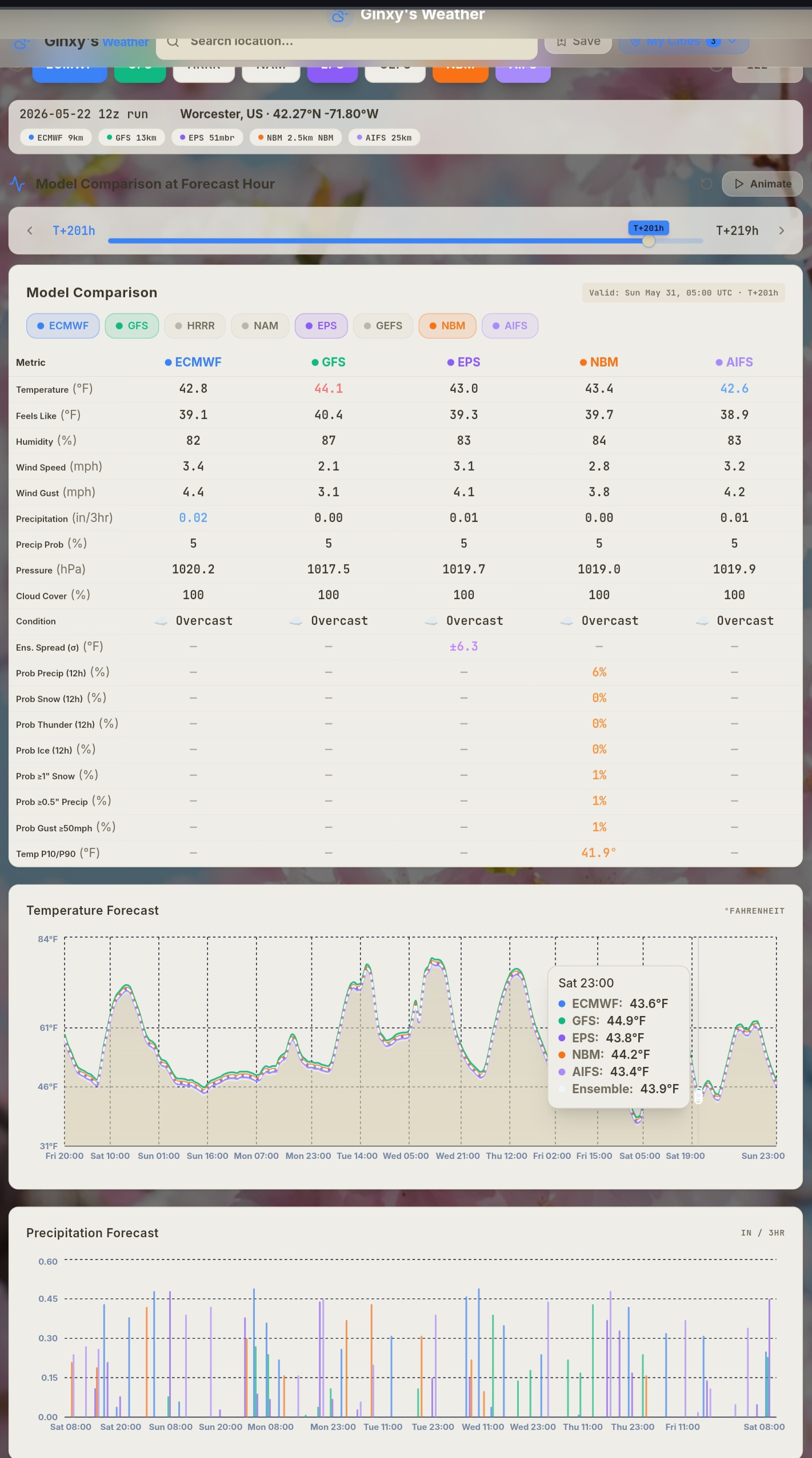
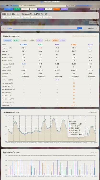
Super Ensemble Modeling Ginxweather.com
-
2.13” last 2 days.
-

2026-2027 Strong/Super El Nino
raindancewx replied to Stormchaserchuck1's topic in Weather Forecasting and Discussion
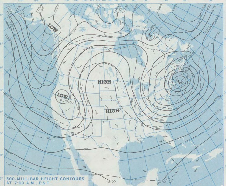
No PDO flip this year. If you call 1957/1958 spiking positive in the -PDO cycle prior as the same point as 2014/2015, we're around 1968 now. We're within a decade, as it's not exact, but I'd bet the PDO doesn't average positive for Nov-Apr. We're probably in something like 1965-66 El Nino strength at 1968 timing cyclically, which was a big El Nino about a decade from the +PDO flip. I'd expect continuing regression toward 0 and a month or two may poke above it, but Nov-Apr won't be over 0. AMO on the other hand...might be this year. Atlantic in May is night and day different to 2023. The colder water by NZ v. 2023 also bodes well for more typical El Nino conditions in the West. Cold/Colder AMO is a decent wet signal and cold signal in winter for a lot of the US. -
32.2 at WXW2 this morning, but man did it turn beautiful.
-

2026 Spring/Summer Mountain Thread
Maggie Valley Steve replied to Buckethead's topic in Southeastern States
Moderate rain with thunder. I'd like you folks input on starting our own SE Region Tropical thread. I know how much trauma Helene brought to our Mountain neighbors. My primary weather focus has always been tropical going up along the Upper Texas Coast. The SE Region covers a tremendous amount of Coastline from Mississippi to the Outer Banks. El Ninos tend to throw a curveball or two not far offshore. If you think the SE posters would participate, let me know.