All Activity
- Past hour
-

January 2026 Medium/Long Range Discussion
NorthArlington101 replied to snowfan's topic in Mid Atlantic
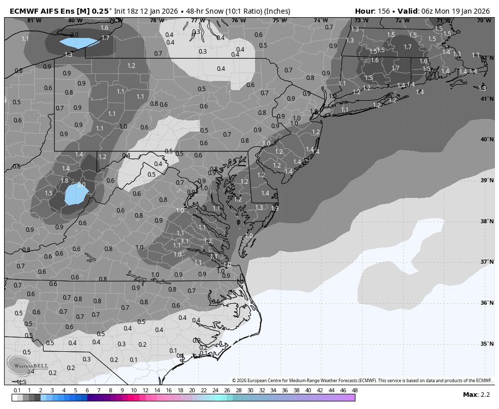
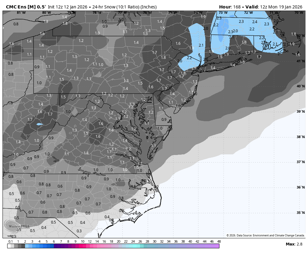
pretty interesting AIFS ens for Sunday-Monday imo. Way more interested than it ever was for Thursday. GEPS really liked it too

-

Pittsburgh/Western PA WINTER ‘25/‘26
colonel717 replied to Burghblizz's topic in Upstate New York/Pennsylvania
Saw KDKA weather playing up lake effect and squalls from Wed Thru weekend. Also, the GFS looked loaded after day 10. Parade of juicy storms. -

January 2026 regional war/obs/disco thread
CoastalWx replied to Baroclinic Zone's topic in New England
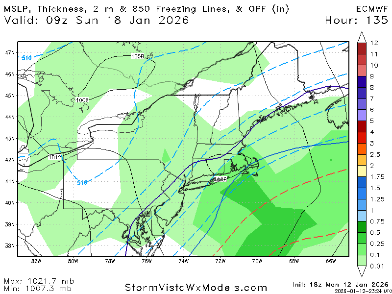
Euro is mostly rain for many. Torch at 925 -
January 2026 regional war/obs/disco thread
CoastalWx replied to Baroclinic Zone's topic in New England
More like rain -
-EPO/+PNA actually leans dry, but it’s also a big dog pattern with that high-latitude blocking. With those AN precip anomalies in our region and the TN valley, I would be more inclined to think Jan 25-Feb 10 has big dog potential rather than cold and dry potential.
- Yesterday
-
I like the -EPO and +PNA for down my way, but that might be too much of a good thing for some of you guys, especially the NW crew. Luckily for them it won't look anywhere near that good as the "warts" come into view as it gets closer. Pretty though.
-
In general I heartily agree. For every suppression risk we have 10x NW trend fails. I'm more worried about the general background state of dryness. As @NorthHillsWx had an excellent point earlier: if it can't rain even when it's warm, what makes us think it can snow? I got zilch yesterday in a warm, muggy airmass.
-
Odd, wasn't it? We always get pure snow every winter. Must be another Gfs error.
-
Truly think this is our biggest problem. The northern stream is very progressive right now, especially without better wave spacing, so we need something to jam up the flow a bit. Need some blocking over Greenland, a stout 50/50, or ideally both.
-
That’s one way to put it
-
What’s your final prediction for seasonal snowfall this year. I still think NYC ends up with 15 at most
-
I'm not throwing in the towel on winter just yet, but I have come to the conclusion that I may like snow a little too much to live here N and mostly East of Corbin usually do really well on these flow events, Corbin not so much, sharp cut off in London
-
Cold outbreaks usually trend less in intensity/extent at verification. Every once in a while that is a good thing for some of us. Last year during that epic Gulf snowstorm, E NC was originally forecast to get nothing as the system was suppressed to oblivion, but the last minute NW trend netted me 3 fluffy inches. The only cold outbreak that I can remember since I really started following weather that did NOT degrade to my knowledge was the Big Chill in late December 2017 early Jan 2018. That seemed to sneak up on me.
-
Noooo. Ji adds charm to this forum lol
-

January 2026 regional war/obs/disco thread
WinterWolf replied to Baroclinic Zone's topic in New England
Well there’s plenty of time..so maybe. -

January 2026 regional war/obs/disco thread
Damage In Tolland replied to Baroclinic Zone's topic in New England
That’s 1-3” for SNE as is . This winter everyone here would strip down and jump in bed to bump and grind with that . -
January 2026 regional war/obs/disco thread
WinterWolf replied to Baroclinic Zone's topic in New England
Very true. Just that at least for me…I don’t care what the lakes get(good for them), but it’s so isolated and mesoscale that it doesn’t really do anything for me, other than a quick glance when they show it on the news. -
damn.
-
You sure? I know you a little nervous lol.
-

January 2026 regional war/obs/disco thread
ORH_wxman replied to Baroclinic Zone's topic in New England
1/18 has been subtly trending a little better today....won't be that interesting unless it continues to do so for another couple of cycles. -
Gotta start somewhere lol
-

2025-2026 Fall/Winter Mountain Thread
Buckethead replied to Buckethead's topic in Southeastern States
I wasn't worried about ground temps. Lol Sent from my Pixel 10 Pro using Tapatalk -
All we gotta do is change the name.
-
Yeah multiple events on the horizon for us. And very cold temps so if anyone is worried about the ground temp don't because it's going to be very cold for several days.
-
Snow for cape