All Activity
- Past hour
-
Not sure about O-line comments, but Harbaugh didn't sugarcoat a lot last night...actually blamed himself for the fumbling problems.
-
Think we sneak out something but how much tbd
-
lol at the sunny forecast
-

December 2025 regional war/obs/disco thread
weatherwiz replied to Torch Tiger's topic in New England
Been weird though because the GFS has underdone some significant differences with H5 evolution. It's also been trending stronger with that trailing shortwave which maybe is acting to amp it up a bit? We're also kind of entering the time period where the GFS seems to have a bias towards this regard. Wouldn't be surprised to see it backed off some Saturday or even Sunday. -
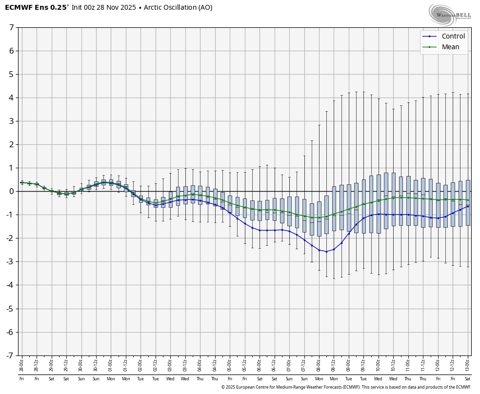
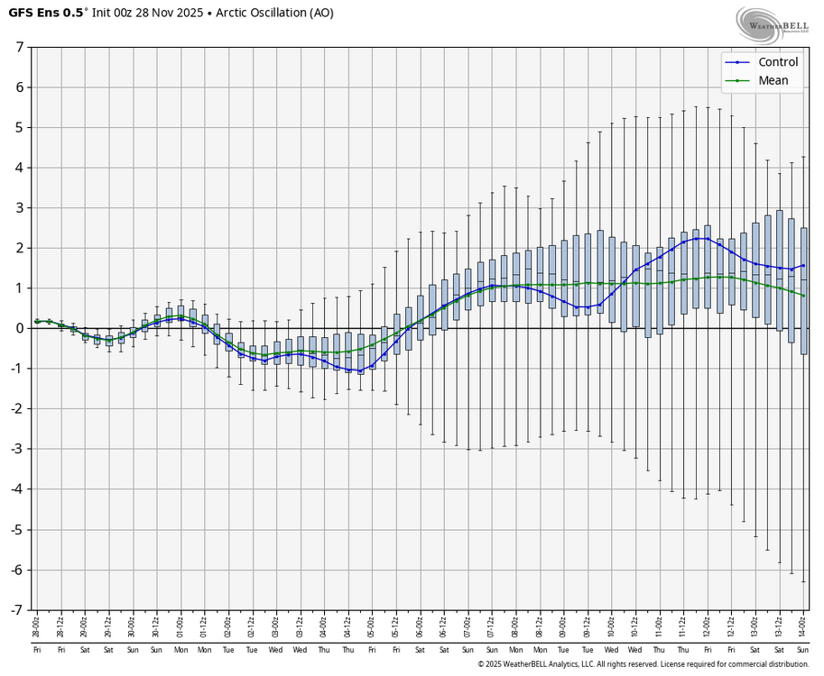
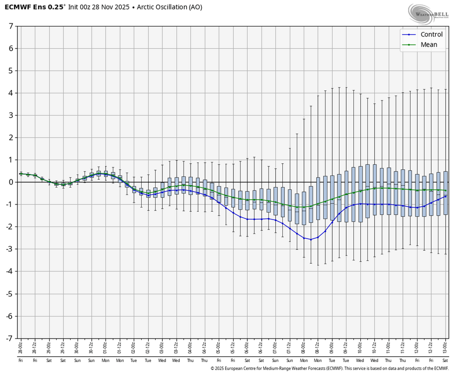
Related to this, check out the differences in the means (green) between the +AO of the 0Z GEFS and the slight -AO of the EPS: GEFS: EPS:
-

December 2025 regional war/obs/disco thread
WxWatcher007 replied to Torch Tiger's topic in New England
Congrats Dendrite? -
Looked like it close to paste there.
-
Well at least Ray and Kevin won’t need to fight lol.
-

December 2025 regional war/obs/disco thread
HoarfrostHubb replied to Torch Tiger's topic in New England
Pivotal clown still has my area mostly snow, but its precarious at best. Lots of sleet in there methinks -
I’d argue GFS has been leading the way with this.
-
Minor revision from previous forecast
-

December 2025 regional war/obs/disco thread
Snowcrazed71 replied to Torch Tiger's topic in New England
I know that that one model seems to be more warm biased and the other colder. Just forgetting which is which. -
December 2025 regional war/obs/disco thread
HoarfrostHubb replied to Torch Tiger's topic in New England
GFS bringing warmth pretty far up n in -

Pittsburgh PA Fall 2025 Thread
TheClimateChanger replied to TheClimateChanger's topic in Upstate New York/Pennsylvania
Officially, on the board at that airport: -
Oof it’s warm
-
Pretty impressed I got this much snow down here...was at a storm total of 5.2" when I measured earlier this morning. Have gotten at least another inch from squalls over the last hour! The HRRR is usually pretty bad with its placement of snow bands but I would say it performed best with this event. It was a few miles too far south (at one point it had me getting 18"), but did a really good job with showing the general area/evolution/organization of the banding that played out compared to the other models.
-
Gfs looks toasty.
-
You have a beautiful large deck, and i love all that white stuff on it.
-
My comment was where Steve is and nothing to do with here. I’ve been saying for days this is not for me. Scooter knows, especially for his locale.
-

Nov 28-30th Post Turkey Day Wintry Potential
IWXwx replied to Chicago Storm's topic in Lakes/Ohio Valley
@Jackstraw Euro is doin' its thing to us.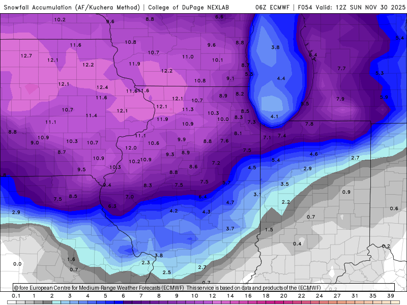
-
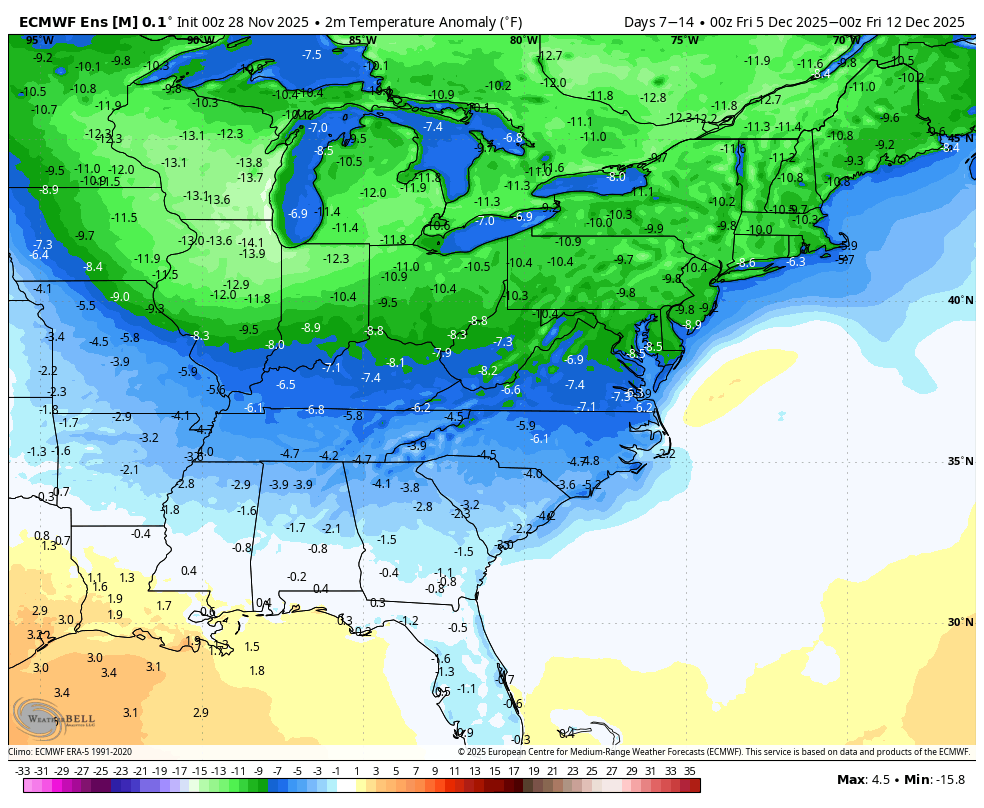
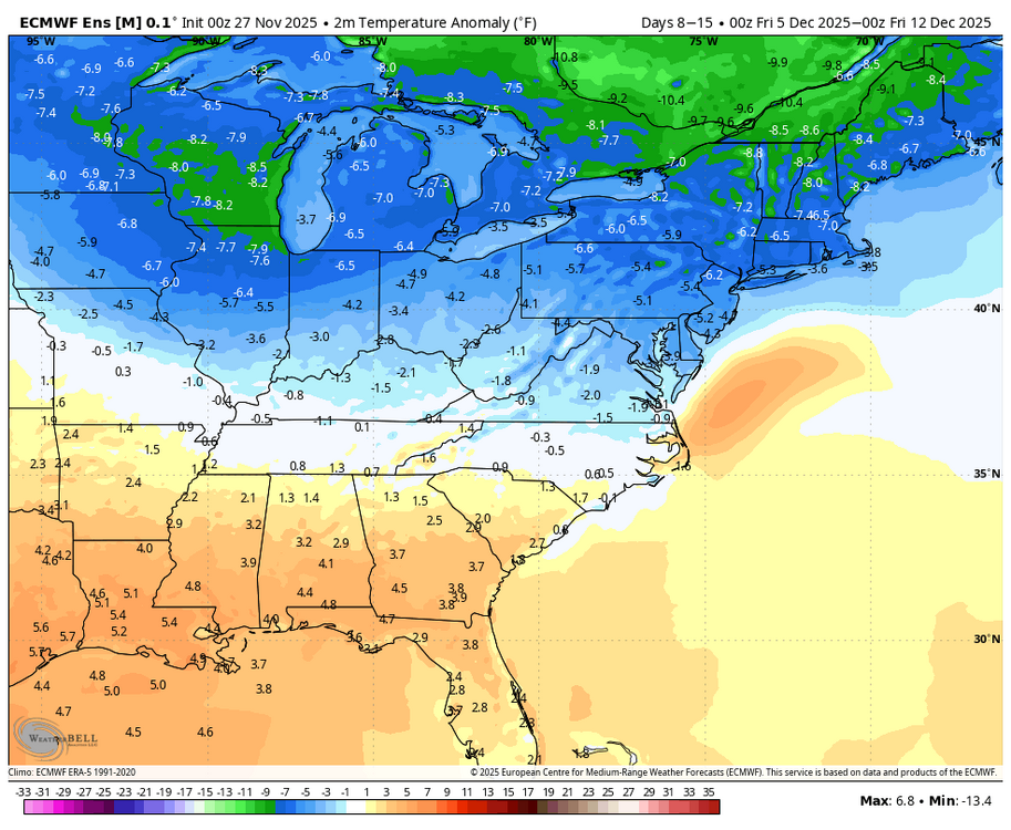
With the unfavorable changes in the MJO and AO/NAO, today’s 0Z GEFS is not surprisingly significantly warmer than yesterday’s run for the 2nd week in Dec. However, today’s 0Z EPS, which maintained its very long phase 8, is much colder than yesterday as well as the GEFS: Yesterday’s 0Z EPS for 12/5-11 2m temps: Today’s 0Z EPS for 12/5-11: it’s pretty rare for a 7 day period of the EPS to have that much of a change within just 24 hours: As a result, the aggregate of today’s Euro Weeklies 12/1-7 and 12/8-14 2m temp anomaly maps will very likely be notably colder than yesterday’s.

-

Nov 28-30th Post Turkey Day Wintry Potential
CheeselandSkies replied to Chicago Storm's topic in Lakes/Ohio Valley
I think you have to go all the way back to 2009 for the last true big dog (double digit totals) prior to December 10th in my memory. That one surely had some compaction involved, because it was low-ratio library paste, yet still flirted with or exceeded a foot in most parts of southern Wisconsin. -
Nice snow showers out here today. 35 degrees. Feels like a perfect winter day.
-
This is the kind of storm that I can imagine looking borderline for snow right down to the Bronx until the NAM sends the vortmax to Buffalo and torches 900mb to 8C... signaling the rest of guidance to rain to Albany. That said, synoptically, right now as modeled, it's pretty close for snow even in the City itself. The ICON and GFS have shifted slightly colder/south at 12z and 6z respectively, and ensembles (if you believe they are useful at this range) are south of their parent operational runs. The antecedent cold is marginally supportive. It wouldn't take a huge change in the shortwave structure aloft to lead to a snowier outcome further south. It's not what I would bet on, but there is still some reasonable chance... especially outside of concrete jungles.
-
Honestly, this isn't the first time this has happened with Monken....but this also happened under Roman too. There is one pretty significant similarity between the two and his initials are JH