All Activity
- Past hour
-

December 2025 regional war/obs/disco thread
brooklynwx99 replied to Torch Tiger's topic in New England
EPS is pretty active after the 22nd or so... there will be chances but it's shut the blinds for the next week -

December 2025 Short/Medium Range Forecast Thread
Daniel Boone replied to John1122's topic in Tennessee Valley
Yeah, we need those Features Opposite of where they are. Hopefully guidance is off with that Depiction. -

December 2025 regional war/obs/disco thread
Ginx snewx replied to Torch Tiger's topic in New England
My thoughts exactly and I talked with Ray about this very subject. -
12z GFS op tries to give everyone a snow, or snow to ice event on 12/23.
-
-
Absolutely possible. The 12/14 event was a highly elevation dependent event.
-

December 2025 regional war/obs/disco thread
Chrisrotary12 replied to Torch Tiger's topic in New England
Going to try to ask a legitimate question without getting yelled at… is it possible you live in a local snow hole? Like… yes you have longitude compared to rest of SNE but your latitude negates it? Perhaps you’re just far enough east that you will dance with the mix line in any event without a parked HP. For SWFEs, you’re just far enough northeast that it takes forever for it to start precipitating and the warm tongue is always closer than it seems. For legit coastals with a parked HP, the coastal front parks well to your east, but you’re in a subsidence zone between CF and next band. I don’t have evidence to support these other than I’ve started picking up and making mental note of them over the years for the Merrimack Valley. -
December 2025 Short/Medium Range Forecast Thread
Daniel Boone replied to John1122's topic in Tennessee Valley
Just carrying on there man. Yeah, that's been the fault during the entire cold period overall. Southern Virginia from about Lebanon Eastward to Va Beach have had a great Stretch with plenty of Snow. -
I'm out here hiking in Crownsville. I can't tell if im tripping or what. I hiked from 180' elevation to 30' elevation and I swear there's more snow at 180. Like an inch more. Is that possible? At higher elevation it could, but here?
-

Central PA Winter 25/26 Discussion and Obs
canderson replied to MAG5035's topic in Upstate New York/Pennsylvania
This is a safe for work site, sir! Weather repaired : I am freezing today. I can’t warm up. -
December 2025 regional war/obs/disco thread
Ginx snewx replied to Torch Tiger's topic in New England
No that's not it. First for example the Euro crushes us. Anyone believe it here. Not talking about the other world. As soon as you can you get on a negative roll. Maybe that's who you like to be but honestly Brett posting the next ten days is crap based on OP GFS is silly. Same as close the shades til after Christmas. We all who love winter want 2015 to walk in the door but reality strikes. Just saying this, scientifically this pattern could be shit or it could explode. Tons of cold air source but...At any rate it will be interesting. -
What's the thinking for the week to 10 days ahead for us mountain folk? Hope we don't get too too warm although I'm not disappointed we won't go through what we did last night for a while.
-
If these clouds can stay in place for another hour to hour and a half I might manage sub-25° high temperature.
-

December 2025 regional war/obs/disco thread
weatherwiz replied to Torch Tiger's topic in New England
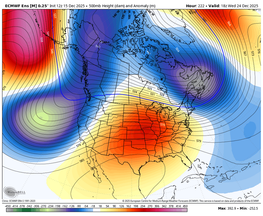
This illustrates beautifully. While using OP at this time range isn't particularly great, I do think there is some value in assessing how the OP is handing the overall evolution of the pattern during that time frame. In doing this, you can see there has been a tendency to somewhat compress the heights a bit and there is also some pretty strong vort maxes modeled...these would further help to flatten that flow out a bit. That look on the ensembles screams some sort of storm potential. I think that period through the first week of January is shaping up to be active. -
Cloudy here, but looks like they dry up as it moves east?
-

December 2025 regional war/obs/disco thread
powderfreak replied to Torch Tiger's topic in New England
This is the internet in a nutshell with all topics. Everything is wrong all the time crowd vs everything is great all the time crowd. Most of us fall on a spectrum of that but there are clear tendencies. -

December 2025 Short/Medium Range Forecast Thread
nrgjeff replied to John1122's topic in Tennessee Valley
Mele Kalikimauka it's gonna be a warm Christmas! Wake me up for the first tornado watch.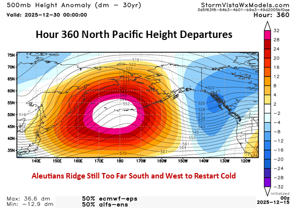
-

December 2025 regional war/obs/disco thread
Damage In Tolland replied to Torch Tiger's topic in New England
Weenies up the middle (hiney)? -
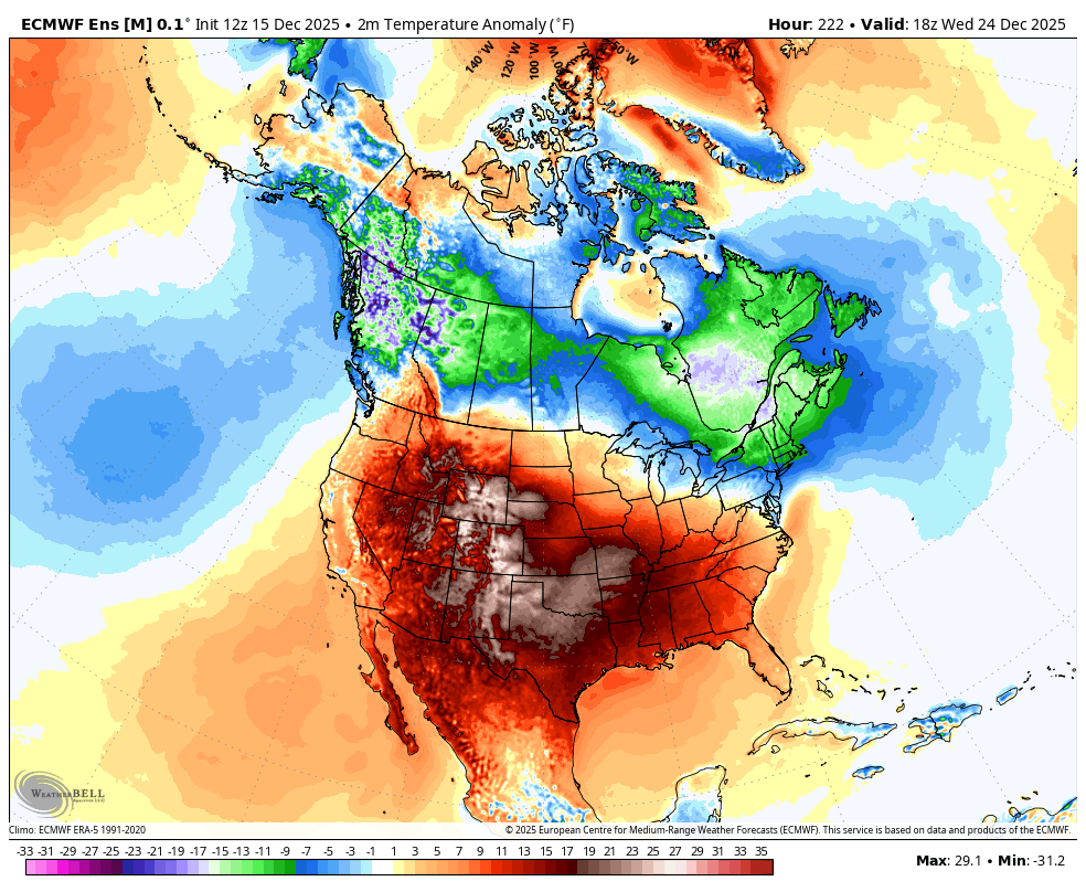
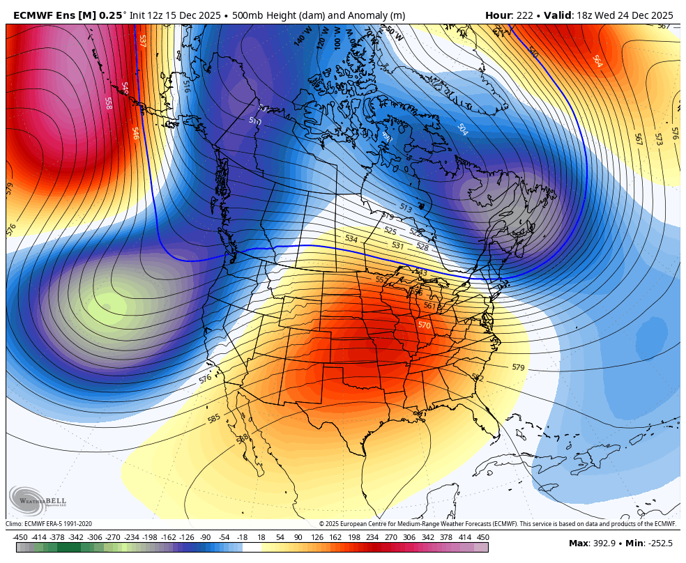
Looks like mild and dry throuhh end of the year. Large ridge over most of CONUS too. Doesn’t look like snow for anyone through end of the month
-
December 2025 regional war/obs/disco thread
brooklynwx99 replied to Torch Tiger's topic in New England
luckily we don't live at 500mb and there can easily be a CAD setup around Christmas with the NW-SE oriented TPV providing confluence
-
12z GEFS (but last few runs also) really leaning into the -NAO developing after Xmas. Bulk that up and a well timed 50/50 low can get something to pass underneath us or provide a CAD event with a low passing to our west.
-
December 2025 regional war/obs/disco thread
weatherwiz replied to Torch Tiger's topic in New England
Yeah there really is no reason to panic or anything yet. It's already been established the surface may not be totally reflective of what is going on in the mid-levels. What we can gather from that period, however, is that it could be active. How those pieces fall into place...way too early to worry about that. -
Yes, that looks to be happening and even if it gets mild somewhat in early January but that may not happen as models have been forecasting warm in the long range and it never materializes. I think we could have indeed some storm threats before Christmas and on Christmas itself.
-

December 2025 regional war/obs/disco thread
Sey-Mour Snow replied to Torch Tiger's topic in New England
Don’t get the pessimism… still a chance for Christmas Eve miracle on AIFS and Euro .. and Euro with a Boxing Day biggie for CNE -

Central PA Winter 25/26 Discussion and Obs
Mount Joy Snowman replied to MAG5035's topic in Upstate New York/Pennsylvania
Alright, so when do we get the shirtless @sauss06 pics?