All Activity
- Past hour
-

September 2025 OBS-Discussion centered NYC subforum
LibertyBell replied to wdrag's topic in New York City Metro
wow it's been very wet in the Poconos! today is my birthday so thanks for the YTD right to my birthday Chris!! -
September 2025 OBS-Discussion centered NYC subforum
LibertyBell replied to wdrag's topic in New York City Metro
It could be the last very warm day of the season, I see my forecast as mid 80s. We have not been warmer than low 80s since the first half of August, it has nothing to do with the ocean as the flow has been NW most of that time and low humidity, good sky conditions. -
Don’t look at the hrrr but how is this in the long range thread
-
AMO state is flipping to negative and it's pretty clear now.
-
all I can say this is MUCH better than the high humidity and flooding rainfalls we were getting year after year. It looks like the cyclic change back to a 1980s type pattern has finally happened.
-
KEd ?
-
It's awesome and 199 is a total bargain Only caveat is that it gets 2nd class citizen treatment from Alterra sometimes, but still great.
-
Coc
-
so glad to return to a 1980s type of pattern
-

2025-2026 Fall/Winter Mountain Thread
ncjoaquin replied to Buckethead's topic in Southeastern States
Picked up a surprise .62 inches(so far) of rain from a shower. Very welcome and much needed. -
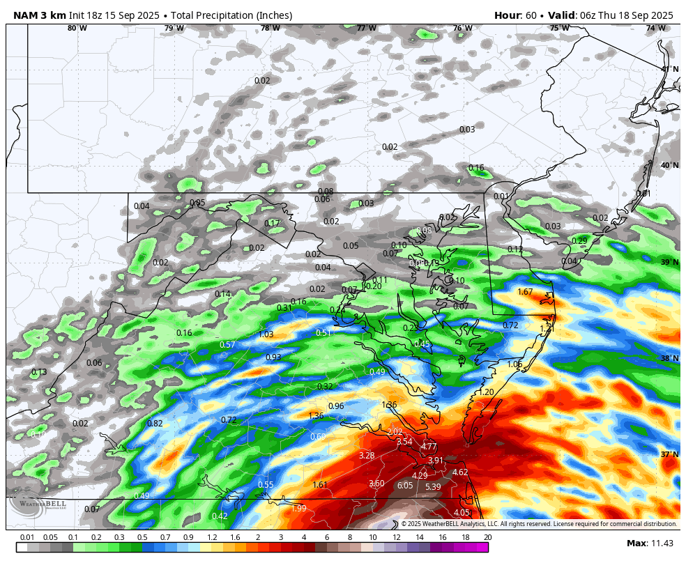
Latest NAM is a disaster if you are looking for rain....WB 18Z 3K NAM

-
12Z UKMET: again has a followup MDR TC to Invest 92L (0Z actually had 2 followups): NEW TROPICAL CYCLONE FORECAST TO DEVELOP AFTER 156 HOURS FORECAST POSITION AT T+156 : 15.9N 37.2W LEAD CENTRAL MAXIMUM WIND VERIFYING TIME TIME POSITION PRESSURE (MB) SPEED (KNOTS) -------------- ---- -------- ------------- ------------- 0000UTC 22.09.2025 156 15.9N 37.2W 1012 31 1200UTC 22.09.2025 168 16.7N 39.4W 1011 32
-
dont look at the 18z HRRR. It took us from Winter Storm Warning to maybe a dusting lol
-
Hugging the euro suite. It’s been a rock while everything else (maybe not GGEM) has been bouncing all over. 18z NAM 3k vs 12z is whiplash.
-
We'll take it:

-
NWS discussion: Clouds will lower and thicken further on Tue with rain or showers slowly spreading further NW through the day Tuesday. Rain/showers should reach the Route 15 corridor by Tue evening. Rain will continue off and on Tue night through Wed as coastal low gets closer to the area. The low pressure center will begin to exit the area Wed night with the rain/showers ending from west to east Wed night. Ensemble guidance suggest half to inch and half of rain may fall along and east of I-95.
-

September 2025 OBS-Discussion centered NYC subforum
SACRUS replied to wdrag's topic in New York City Metro
Still upper 60s - low 70s -

September 2025 OBS-Discussion centered NYC subforum
donsutherland1 replied to wdrag's topic in New York City Metro
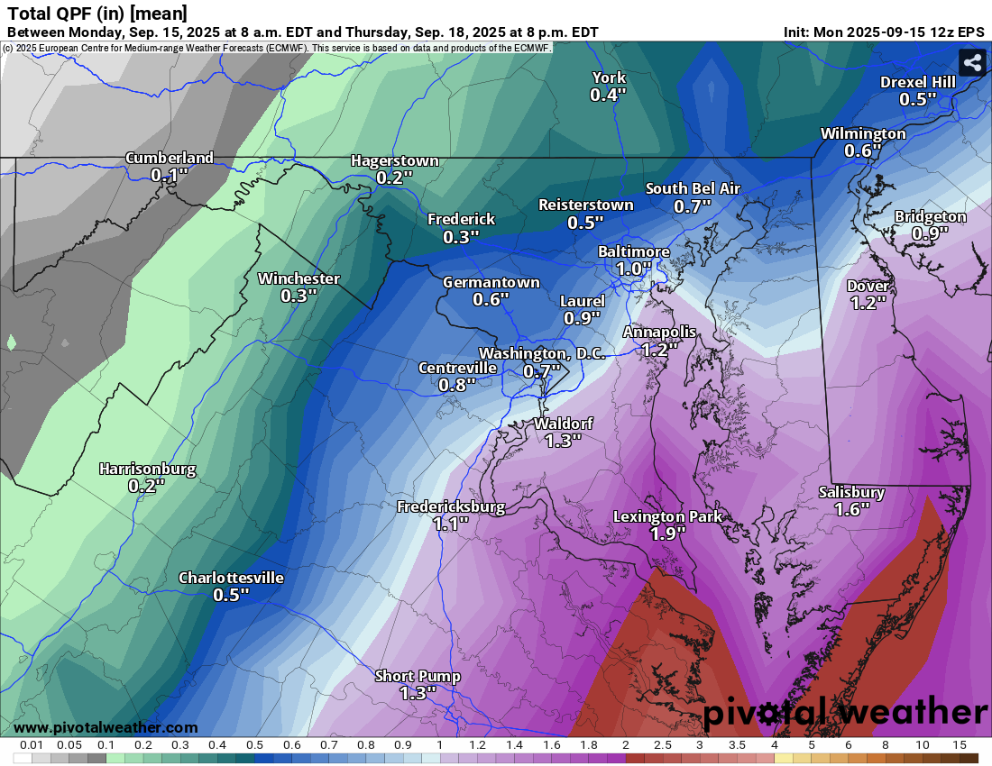
Temperatures will reach the lower to middle 70s tomorrow and mainly the lower 70s on Wednesday. Readings will likely return to the upper 70s on Thursday and the lower 80s on Friday. Cooler air should return for the weekend. In terms of near-term precipitation, a cutoff system near the Delmarva could bring some showers or a period of rain on Wednesday into Thursday. Parts of the Delmarva and Jersey Shore will likely see the heaviest amounts. The ENSO Region 1+2 anomaly was -0.2°C and the Region 3.4 anomaly was -0.5°C for the week centered around September 10. For the past six weeks, the ENSO Region 1+2 anomaly has averaged +0.10°C and the ENSO Region 3.4 anomaly has averaged -0.37°C. La Niña conditions will likely develop during mid- or late-autumn. The SOI was -0.18 yesterday. The preliminary Arctic Oscillation (AO) was -0.603 today. Based on sensitivity analysis applied to the latest guidance, there is an implied near 56% probability that New York City will have a cooler than normal September (1991-2020 normal). September will likely finish with a mean temperature near 68.9° (0.3° below normal). Supplemental Information: The projected mean would be 0.9° above the 1981-2010 normal monthly value. -
And a drain line from my kitchen sink decided to crack and leak all over the place. best part? It was in the wall and not in the crawlspace. That would be too easy
-
Well shit. Jayden Daniels has a knee sprain
- Today
-
-
It's not technically tropical because it's not a "warm core" system. It's attached to a frontal boundary and has characteristics of a mid-latitude cyclone. Regardless, the impacts on the beaches will be the same as a weak tropical storm. Erosion/Overwash in the normal places is likely in the OBX.
-
Jennette’s Pier in Nags Head is now gusting up to 60! Quite the coastal low EDIT: duck pier gusted to 58
-
Indeed. Looks rough! https://www.surfchex.com/cams/avon/
-

September 2025 OBS-Discussion centered NYC subforum
psv88 replied to wdrag's topic in New York City Metro
My kids were swimming off the boat on the north shore yesterday. Some of the protected harbors still in the mid 70s by late afternoon on the warmer days