All Activity
- Past hour
-

Southern Crippler - Get well soon Jimbo Storm Obs
WinstonSalemArlington replied to BooneWX's topic in Southeastern States
Yep -

January 2026 regional war/obs/disco thread
Prismshine Productions replied to Baroclinic Zone's topic in New England
Wind chill in the Bahamas in the upper 30s/lower 40s on the Timbit... Damn Sent from my SM-S166V using Tapatalk -

Extreme Cold, Snow & Sleet: SECS 1/24 - 1/26
NorthShoreWx replied to TriPol's topic in New York City Metro
That intersection is 8 road miles for me; less for the proverbial crow. There's some pretty good hills just to the sw of the interchange. -
Snow, very small fine flakes. Dusting on all surfaces.
-
Moderate snow with small flakes in Colonial Beach. 21F
-
15/-6. Cloudy & overcast with flakes nearby.
-
First flakes in northwestern HoCo
-

Southern Crippler - Get well soon Jimbo Storm Obs
Coach McGuirk replied to BooneWX's topic in Southeastern States
Austin, Texas? -

Extreme Cold, Snow & Sleet: SECS 1/24 - 1/26
Bxstormwatcher360 replied to TriPol's topic in New York City Metro
Ratio chart. Onset liquid equilivent to snow is going to be bonkers. Other factors may slightly differ in ratios itself such as winds and upper air conditions.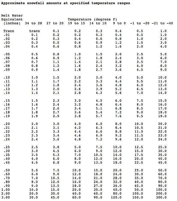
-
January 2026 regional war/obs/disco thread
Prismshine Productions replied to Baroclinic Zone's topic in New England
Bruh -
Can barely see the snow falling but whitening up very quickly. Roads immediately caved of course.
-
“Cory’s in LA! Let’s MECS!” Jan. 24-26 Disco
Prismshine Productions replied to TheSnowman's topic in New England
Dude everything alright?... Sent from my SM-S166V using Tapatalk -
I’m at the intersection of the SAG and the northern state. That 7/8 miles seems right
-
Wow if Georgetown isn’t seeing rain we are in for a good one.
-
 There wasn't nearly as much sleet as most models predicted, which is why I've gotten so much freezing rain. Especially crazy sleet totals the Canadian with some of its wonky runs. It got the idea of the mix storm first, but had too much sleet. But it often overdoes cold, so I assume that happened here.
 -

Richmond Metro/Hampton Roads Area Discussion
Conway7305 replied to RIC Airport's topic in Mid Atlantic
Good Stuff in Powhatan now. Moving our way. -
Extreme Cold, Snow & Sleet: SECS 1/24 - 1/26
NorthShoreWx replied to TriPol's topic in New York City Metro
Not sure precisely where you are, but my best guess is 7 or 8 miles tops (maybe less) as the crow flies. Plus I'm only at 122 feet. Spots near you are up to 300. I'll gladly take the foot. Molto grazie. Addendum: either way, our streets are going to look the same in a few days, and it will be a good look. -
Thank goodness this wasn’t a 3/4 am stsrt , By 3/4 we should be able to rest a bit .
-
18/4 and flakes are falling here on Kent Island .
-

Southern Crippler - Get well soon Jimbo Storm Obs
DC2Winston replied to BooneWX's topic in Southeastern States
Ground truth of the flip back to “snizzle” in the Triad. Pixie dust light snow and white ground. Perhaps short lived but E-Webb spot on. . -

Southern Crippler - Get well soon Jimbo Storm Obs
85snowline replied to BooneWX's topic in Southeastern States
Light pixie dust snow in Concord… incredible -
https://www.meteo.psu.edu/ewall/WXTYPE/loop25ne.html
-

Extreme Cold, Snow & Sleet: SECS 1/24 - 1/26
nycsnow replied to TriPol's topic in New York City Metro
Btw just for fun euro ai is 12+ for most -

Southern Crippler - Get well soon Jimbo Storm Obs
kvegas-wx replied to BooneWX's topic in Southeastern States
Convective part of the system coming out of the gulf now. Temps shooting up well into southern TN. This wedge is unbreakable in the Triad north into VA. So my concerns for heavier ZR overnight are going up. Looking very juicy headed into daylight hours. -
Absolutely massive amounts of clear frigid air falling from the sky rn. I don’t know if my powerful Ariens snowblower can handle this … 17F/-4F 30.65 in pressure RH 40% Virga on the doorstep extreme NE MD (MD/PA/DE line) one of MD’s famous snow anuses


