All Activity
- Past hour
-

Central PA Spring 2026 Discussion/Obs Thread
Itstrainingtime replied to Voyager's topic in Upstate New York/Pennsylvania
That's an interesting point and something I was thinking about last week - very rarely does SPC scale back on their outlooks until the event has passed any given area of the country. I honestly can't remember it happening though I'm sure it has. Very high percentage of the time the map gets expanded, though. -

E PA/NJ/DE Spring 2026 Obs/Discussion
Voyager replied to PhiEaglesfan712's topic in Philadelphia Region
Like I said to Mikeymac, I may not understand the love of winter, but I at least try to respect it. -

2026-2027 El Nino
snowman19 replied to Stormchaserchuck1's topic in Weather Forecasting and Discussion
-
Looking like a wet pattern will be developing
-
I know it ain’t even April and this is kinda like someone calling off winter before January, but severe season in the mid south east of the Mississippi river ain’t looking so great this year. Week 2 and 3 from NIU… yikes .
-
If it’s above freezing at night it’s a beautiful day.
-
Saw my first flash of lightning of 2026 driving into work this morning. Storm missed me to the north.
-
 @so_whats_happening, I helped grade once back 6 years ago or longer maybe for a month, Central Park was used for NYC, the Denver airport was used, and Sea-Tac for Seattle, O'Hare for Chicago, Bush for Houston.
 - Today
-
Yeah agree. Could be a wet summer. Hopefully means storms.
-
3 weeks ahead? Wine?
-
The early spring continues on track. It just doesn’t look or feel great because, well, it’s Mahch and early April in New England. The latest guidance looks like we’ll be about three weeks ahead of last year in terms of the green up. I don’t see one morning below freezing after this weekend, the 29th , in seacoast NH.
-
I would expect more of that this summer...not going to get into summer outlooks because frankly, the interest isn't there and I'd end up fired and divorced...but I think the smart money is on the emergence of a much wetter pattern.
-
Perfect time of year to check out of the weather and immerse oneself in baseball.
-
0.02” Some breaks to the north 36.7°
-

2026-2027 El Nino
40/70 Benchmark replied to Stormchaserchuck1's topic in Weather Forecasting and Discussion
IMHO the default position should be that it will relocate given a strong enough El Nino because that is what has always happened...sure, you could argue that the magnitude and residence of this particular warm pool is unprecedented, but I can tell you what else is unprecedented....ANY type of pattern or SST signature becoming a permanent fixture in the hemisphere (general warming notwithstanding), so in that sense we have plenty of evidence. This is akin to me arguing that the warm east/cold west/+WPO pattern wasn't permanent, which we now know for certain. -
2026-2027 El Nino
40/70 Benchmark replied to Stormchaserchuck1's topic in Weather Forecasting and Discussion
I think we could eliminate the possibility of a high-end NE snowfall outcome in that case...mid Atlantic is different since they don't average as much and can exceed their seasonal allotment in one storm given the powerful STJ. I am with you on the cold...even if we do get a 2002-2003 or 1957-1958 type of El Nino, I don't anticipate it being as consistently cold as last season. -
Box AFD has the rain well over the ocean by daybreak. Meanwhile it’s raining back to the Berks
-

2026-2027 El Nino
bluewave replied to Stormchaserchuck1's topic in Weather Forecasting and Discussion
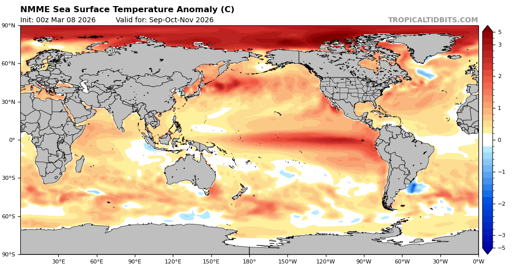
The new normal has been record marine heatwaves across multiple ocean basins influencing our sensible weather. Oscillations and teleconnections will continue to exist. But the competing nature of the marine heatwaves will allow them to be expressed in new ways. The next question is what becomes of the record SST warmth east of Japan that we have been experiencing since the late 2010s? I see you are in the same camp with Paul. I haven’t taken a position yet on whether a strong enough El Niño can cause it to shift to another part of the Pacific basin. So right now I am in the open camp since I don’t have enough data to make a call yet. But I agree with you that we would need to significantly weaken it to allow for a very strong +PDO to emerge which we last saw back in 2015. The long range climate models maintain the warm pool there into the late fall and perhaps early winter. Beyond that point who really knows. But it will be interesting to see how things play out going forward. Since we have never experienced a warm pool there if this magnitude lasting nearly a decade before.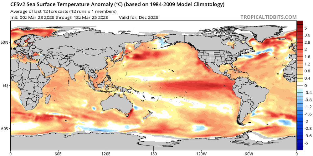

-
Yeah. I didn’t really expect rain this morning. lol at my point n click saying mostly sunny today.
-

Central PA Spring 2026 Discussion/Obs Thread
mahantango#1 replied to Voyager's topic in Upstate New York/Pennsylvania
Dauphin County should be included in this if you look at SPC's map. Hazardous Weather Outlook National Weather Service State College PA 422 AM EDT Thu Mar 26 2026 PAZ006-011-012-018-019-025>028-034>037-041-045-046-049>052-056-063- 064-270830- Potter-Cameron-Northern Clinton-Northern Centre-Southern Centre- Blair-Huntingdon-Mifflin-Juniata-Bedford-Fulton-Franklin-Tioga- Northern Lycoming-Southern Clinton-Southern Lycoming-Union-Snyder- Montour-Northumberland-Perry-Cumberland-Adams- 422 AM EDT Thu Mar 26 2026 This Hazardous Weather Outlook is for central Pennsylvania. .DAY ONE...Today and tonight. Strong thunderstorms with heavy rainfall are possible this evening into early tonight. -
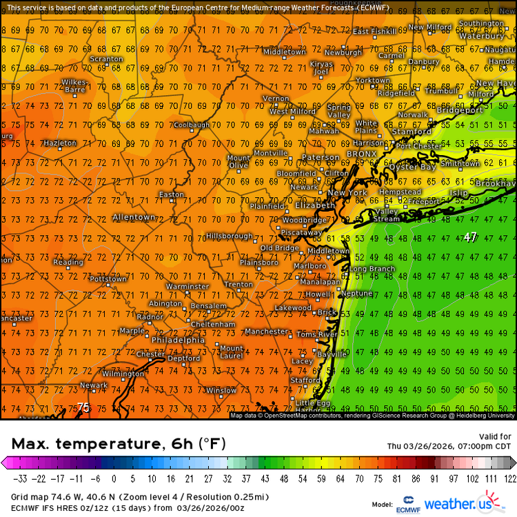
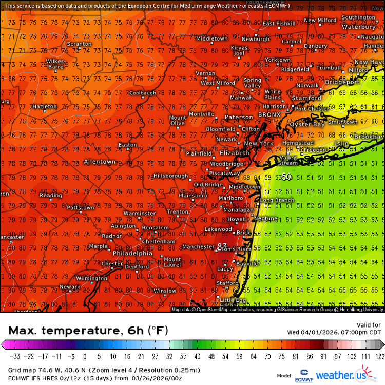
The warm spots will make a run on 70° today and 80° next week.
-
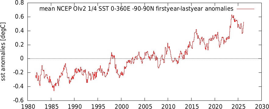
a Here's another perspective on the oiSST data which shows the similarity to 2023. The last data point is March to date.
-
2026-2027 El Nino
snowman19 replied to Stormchaserchuck1's topic in Weather Forecasting and Discussion
Only a moron would lock anything in, in March. I haven’t seen anyone lock in an east-based super El Niño on here or even on twitter. Is there an increased chance of one? Yes. Especially if those twin TC’s along the record WWB verify. That said, IF, if, if we actually do see an east-based/East Pacific super El Niño, I can say with very good confidence that it will not be an arctic cold winter, regardless of what the QBO and stratosphere/SPV and solar do. Snow is a completely different matter since we’ve seen 2 record breaking KU blizzards during super El Niños, most recent being the 2015-16 super El Niño which saw the January, 2016 blizzard. Even the east-based super El Niño of 1982-83 had the Megalopolis blizzard in February, 1983. 1997-98 was obviously a wall to wall dud for snow until the first day of astronomical spring in March, 1998, when NYC saw 5 inches of snow, which was the only snowstorm of that entire winter for them….. -

E PA/NJ/DE Spring 2026 Obs/Discussion
Birds~69 replied to PhiEaglesfan712's topic in Philadelphia Region
Seriously? You like sweating constantly? Gnats, mosquitoes? Allergies? Hearing leaf blowers at 7am on weekends? If the Phils suck no real home town sports to watch? No real holidays? Ok, the 4th a little. And dead looking landscape? Have you seen a dry summer? We had many (consult drought guy)...ya know where the grass turns yellow-brown and crunchy where you can't even walk on it w/bare feet. Bottom line, the summer sucks for the most part besides severe weather, some fishing/gardening and you have to pray the Phils don't suck. But I'm usually sick of it come mid July and can't wait till Fall. But yeah, people who love hot weather (95F+/DP 70F+) are mentally ill or have frontal lobe damage..... -

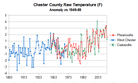
Chester County PA - Analytical Battle of Actual vs. Altered Climate Data
chubbs replied to ChescoWx's topic in Climate Change
OK I took an initial stab at consolidating the data using Chester County's 3 long-term COOP stations. My consolidation doesn't look at all like your "analytics". Why? I only use periods without major station moves: 1949-2025 for Coatesville and Phoenixville and 1894-1969 for West Chester. I also use the 1949-1969 overlap period to take out the temperature difference between the 3 stations. While it doesn't look like your "analytics", my consolidation is a good match to the data collected at individual Chester County stations, posted above. That's gives my confidence in this approach and I plan to extend this method to the rest of the data.