All Activity
- Past hour
-
Ha, or the Kingdome in Seattle back in the day. Was in Seattle in the mid-90s when they had A-Rod, J Buhner, Ken Griffey Jr, and Edgar Martinez and would hit multiple home runs a game. Every time they'd set off fireworks, and the smoke would start settling down with each consecutive homer. By the late innings you were praying for good opponent relief pitching.
-
I told you you didn't want anything to do with what was north of you. Hanging out in the mid to high 400's overnight. Looking for relief later today.
-
After avoiding the worst yesterday, we are in the thick of the smoke here. AQI over 400. Smells nasty.
-
Seems even worse this morning. The sun is no longer visible and visibility is low. Crazy stuff.
-
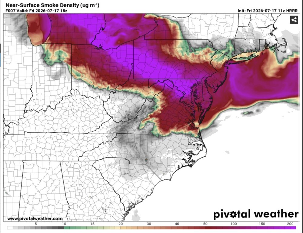
Still a little bit of low level smoke, but skies are much clearer overall. It's great seeing the sun again! HRRR brings the smoke back in later tonight with the sea breeze. Looks pretty clear by Sunday
-
NYC needs to pick up 2.77” by the end of July to have their first average to above precipitation month since May 2025. https://forecast.weather.gov/product.php?site=NWS&issuedby=NYC&product=CLM&format=CI&version=1&glossary=1&highlight=off Monthly Total Precipitation for NY CITY CENTRAL PARK, NY Click column heading to sort ascending, click again to sort descending. 2026 2.70 2.60 3.60 2.48 3.05 3.39 1.83 M M M M M 19.65 2025 0.61 2.60 5.52 3.25 6.58 2.46 4.03 2.21 2.76 4.08 2.09 3.38 39.57 2024 5.28 2.05 9.06 3.47 4.11 1.71 4.20 7.02 1.58 0.01 3.35 4.53 46.37
-
For as bad as the AQ is right now, if you are old like me this is nothing compared to going to a Caps game at the old Cap Center in the early 80s
-
Really a bummer. Ducks game is gonna be cancelled. Bought a bunch of tickets. Fireworks were supposed to be after.
-
.thumb.jpg.6a4895b2a43f87359e4e7d04a6fa0d14.jpg)
Central PA Summer 2026 Discussion/Obs Thread
Yardstickgozinya replied to Voyager's topic in Upstate New York/Pennsylvania
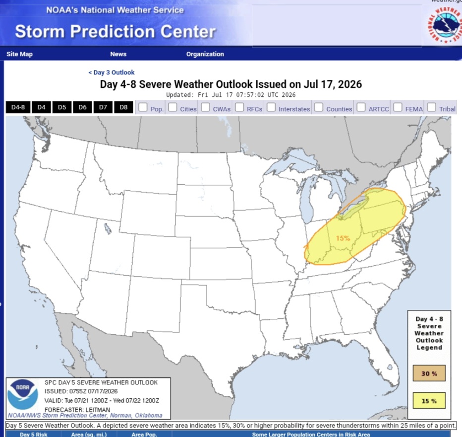
Tuesday Day 5 Days 4-6/Mon-Wed -- Great Lakes/Midwest to the Mid-Atlantic/Northeast... A shortwave upper trough initially over the Canadian Prairies and northern Plains will develop east/southeast across the Upper Midwest/Great Lakes on Monday, then the Ohio Valley and Mid-Atlantic vicinity on Tuesday. Meanwhile, another upper shortwave trough will develop across the Great Lakes to the Northeast/Mid-Atlantic on Wednesday. These features will support enhancement of mid/upper level flow as a surface low tracks across Ontario/Quebec and New England during this time. A trailing cold front will likewise progress east/southeast over this three day period, with a very moist and unstable airmass present ahead of the front. This overall pattern will likely bring multiple days of severe storm potential from the Upper Midwest/Great Lakes to portions of the Ohio Valley, Northeast and Mid-Atlantic vicinity Monday through Wednesday, necessitating severe probabilities. While these areas may shift some over the coming day as the timing of mesoscale features and influence of prior days convection becomes more clear, these general regions are most likely to see at least isolated to widely scattered damaging wind potential as the upper trough and surface cold front sweep across the area.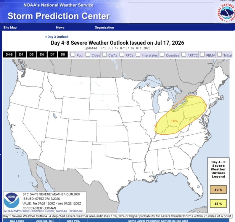
-
Really incredible smoke plume. Its made its way to the DC area. Readings similar to whats in the great lakes. And yeah no birds singing here either.
-
 They are setting records with relatively moderate strength ridging. When/if one of those 600dm+ ridges parks over this area they will blow those margins away.
 -
Records: Highs: EWR: 100 (2012) NYC: 100 (1953) LGA: 98 (2012) JFK: 97 (1969) Lows: EWR: 56 (1946) NYC: 57 (1892) LGA: 60 (1946) JFK: 61 (1989) Historical: 1902: Temperature range was 38° from 58° minimum to 97° maximum in Baltimore City, MD. 1934 - One of the worst heat waves in the history of the nation commenced. During the last two weeks of the month extreme heat claimed 679 lives in Michigan, including 300 in Detroit alone. (The Weather Channel) 1941 - A prolonged heat wave over Washington State finally came to an end. Lightning from untimely thunderstorms was responsible for 598 forest fires. (David Ludlum) 1942: A great flood developed over the Smethport area in Pennsylvania, resulting in an estimated 34.50 inches of rain in just one day, including 30.60 inches in only six hours, setting a world record. The official observing site, Smethport Highway Shed, reported only 13.08 inches for the entire month because the flood consumed the gauge after 6.68" of rain. The total results from the substitution of the officially estimated amount for the amount measured. 1943: Col. James Duckworth became the first person to fly an airplane into a hurricane. Duckworth took his AT-6 trainer right into the eye of a category 1 hurricane off the Texas coast. (Ref. Wilson Wx. History) 1952 - Thunderstorms helped the temperatur at Key West, FL, to dip to 69 degrees, to equal their July record established on the first of July in 1923. (The Weather Channel) 1957 - On a warm and sunny day at Wilmington, DE, with a high of 86 degrees, a dust devil suddenly appeared. It tore most the roof off one house, and stripped shingles from a neighboring house. A TV aerial was toppled, and clothes were blown off clothes lines. (The Weather Channel) 1978: Severe thunderstorms ripped across southwest sections of South Dakota. One storm which dumped hail larger than golf balls and had winds which exceeded 80 mph was labeled as one of the most destructive to strike several western counties. Bennett County alone lost 20,000 acres and 600,000 bushels of unharvested winter wheat. The storms also did considerable property damage. Total price tag for the storms was near $28 million dollars. (Ref. Wilson Wx. History) 1980: The maximum temperature ever recorded in Atlanta, GA was 105 °F on this date. The maximum temperature ever recorded in Macon, GA was 108 °F on this date. The high of 110 degrees at Newington, GA was just two degrees shy of the state record. (Extreme Weather pp. 22, 273, by Christopher C. Burt) 1981: Severe thunderstorm winds ripped a 10,000 square foot hole in a 90-foot high pavilion at Sea World in Orlando, FL. The storm panicked a crowd of 550 tourists. One death occurred due to injury and heart attack, and 15 people were injured. The canopy was made of fiberglass and Teflon, designed to withstand 120 mph winds. 1985: An F1 tornado touched down, 10 miles east of Raymond, SD destroying two cattle sheds and several buildings. Heavy rains, strong winds and hail up to 2.75 inches in diameter produced considerable damage to farm buildings between Raymond and Garden City. Rainfall amounts of 3 to 6 inches caused additional crop losses from erosion. A thunderstorm near Kennebec produced wind gusts to 80 mph and small hail was observed. Several car windows were broke from wind and small hail. A damage path from wind and hail continued to Clear Lake, to south of Gary and into Minnesota to the east of Canby. Winds gusted to 70 mph and hail ranged from one to almost two inches in diameter. Highway 77, south of Clear Lake was impassable due to hail on the ground. (Ref. Wilson Wx. History) 1987 - Slow moving thunderstorms caused flooding on the Guadalupe River in Texas resulting in tragic loss of life. A bus and van leaving a summer youth camp stalled near the rapidly rising river, just west of the town of Comfort, and a powerful surge of water swept away 43 persons, mostly teenagers. Ten drowned in the floodwaters. Most of the others were rescued from tree tops by helicopter. (The National Weather Summary) (Storm Data) 1988 - A dozen cities in the eastern U.S., and six others in California, reported record high temperatures for the date. Downtown San Francisco, CA, with a high of 103 degrees, obliterated their previous record high of 82 degrees. Philadelphia, PA, reported a record five straight days of 100 degree heat, and Baltimore, MD, reported a record eight days of 100 degree weather for the year. Afternoon and evening thunderstorms produced severe weather along the Middle Atlantic Coast, and over southern New England. (The National Weather Summary) 1989 - Thunderstorms produced severe weather from South Dakota to Lousiana, with 126 reports of large hail and damaging winds during the day and night. Thunderstorms in Nebraska produced hail four inches in diameter in Frontier County, and at North Platte, causing millions of dollars damage to crops in Frontier County. Thunderstorms in Oklahoma produced wind gusts to 90 mph at Peggs. Tahlequah OK was drenched with 5.25 inches of rain. (Storm Data) (The National Weather Summary) 1993: All-time monthly record rainfall established already at Concordia, KS as rainfall records continued to fall across the Midwest during the Great Mississippi Flood of 1993. Total rainfall so far was 13.26”; this broke the old record of 11.19”. On this date, two inches of rain fell in 12 minutes in parts of Montgomery County, Iowa. 12 inches fell in just three hours near Bamboo, WI. (Ref. Wilson Wx. History) 1994: Atlanta, Georgia saw a record-tying, 14 straight days come to an end on this day. The entire month of July had 17.71 inches, the wettest month ever in the Georgia capital. 1995: A 15-year-old boy was injured by lightning while touching an outdoor light switch at a swim and tennis club just outside Charlottesville, VA . He had been playing tennis and was leaving the courts due to the storm when he was struck. (Ref. Lightning - Virginia Weather History) 1997: Tropical Storm Danny strengthened in the Gulf of Mexico off of the Louisiana Coast and moved slowly toward land. This marked only the third time in 126 years that four tropical storms had formed so early in the season (1886, 1959 were the other years). The storm would eventually stall over Mobile Bay, dumping incredible amounts of rain on the Alabama coast. (Ref. Wilson Wx. History) 2000: Intense storms produced a vivid lightning display in the early a.m. over Kansas City, KS/MO. 2,000+ cloud-to-ground bolts hit Johnson County between 2-3 a.m.; the number of intracloud bolts may have exceeded 20,000 in the same time span. (Weather Guide Calendar with Phenomenal Weather Events 2011 Accord Pub. 2010, USA) 2003: Denali National Park, Alaska: One inch of snow falls at Denali National Park Headquarters, the first occurrence of measurable snow ever recorded in July. (Ref. WxDoctor) 2005: Needles, CA reached a high temperature of 125°, recording their hottest temperature ever. Other daily records included: Palm Springs, CA: 121°, Borrego Springs, CA: 120°, Yuma, AZ: 117°, Las Vegas, NV: 116°, Phoenix, AZ: 116°, Kingman, AZ: 113°, Tucson, AZ: 111° and Winslow, AZ: 105°. (Ref. Wilson Wx. History)
-
 Nastiness moving through tomorrow night. Probably some violence western areas
 -
76 / 61 partyl cloudy with the worst of the smoke heading south. Mid 80s to 90 in the warmest locations. Saturday severe risk and rain / flood potential increasing. Clearing out for t=Sunday world cup game. Trough into the northeast 7/19 - 7/24 more rain/storm chances Tue-Wed keep heat south, enough sun / less rain could see temps spike wed-thu. Overall near / below normal the next week. 7/27 and beyond western heat coming east , see if the W. Atlantic ridge retro back west.
-
Central PA Summer 2026 Discussion/Obs Thread
Yardstickgozinya replied to Voyager's topic in Upstate New York/Pennsylvania
It got nasty out there last night while I was at my Colombia hole.. The Mayflies and the smoke were unbearable but my patients paid off. Sat out in this s*** all night last night, probably not the healthiest thing to do..thumb.jpg.8070da967ee470995b5d14b680187f04.jpg)
-
The birds woke up this morning and were like I ain't singing in this shit.
-
Doubtful HRRR increases surface smoke this afternoon.
-
My memory is that 2023 smelled like a wet, stale campfire. Agree with @dailylurkerthat today has more tire-fire notes
-
Woot, DP down to 65 here. Hazy, with slightly detectable aroma.
-

Central PA Summer 2026 Discussion/Obs Thread
mahantango#1 replied to Voyager's topic in Upstate New York/Pennsylvania
252 µg/m3 Hazardous Avg262.4 Peak455 63.5° Dew Point 63.2°F From Yesterday 8.3°F Feels Like 63.5°F Yesterday afternoon was really bad here. with a peak of 455 -
All we can do is hope its correct. Got a gathering tonight im probably going to cancel.
- Today
-
I agree, just pointing it out.
-
I seen that but i call bullshit personally













.jpg.736578fda8bbb24521170645f3af4776.jpg)