All Activity
- Past hour
-
 Dews are plummeting
 -

2026-2027 Super El Nino
LakePaste25 replied to Stormchaserchuck1's topic in Weather Forecasting and Discussion
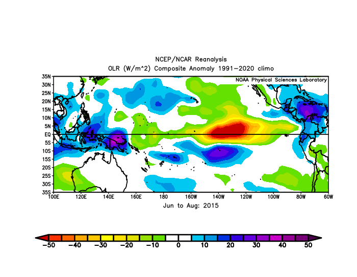
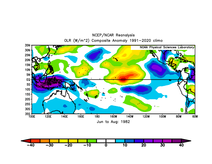
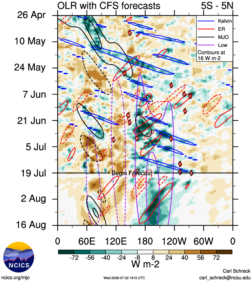
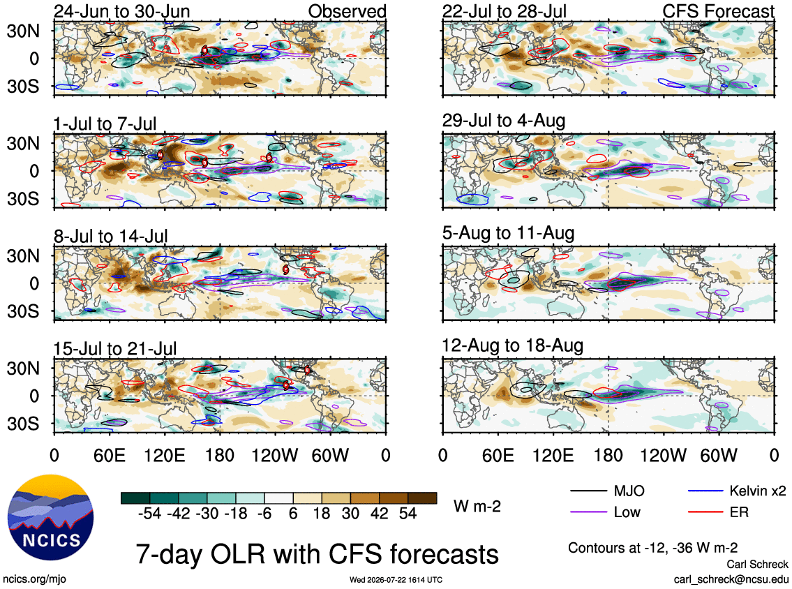
Looking at past OLR, it looks closest to 1982…maybe a tad west. It does have that broad convective signature across the basin though similar to 1997.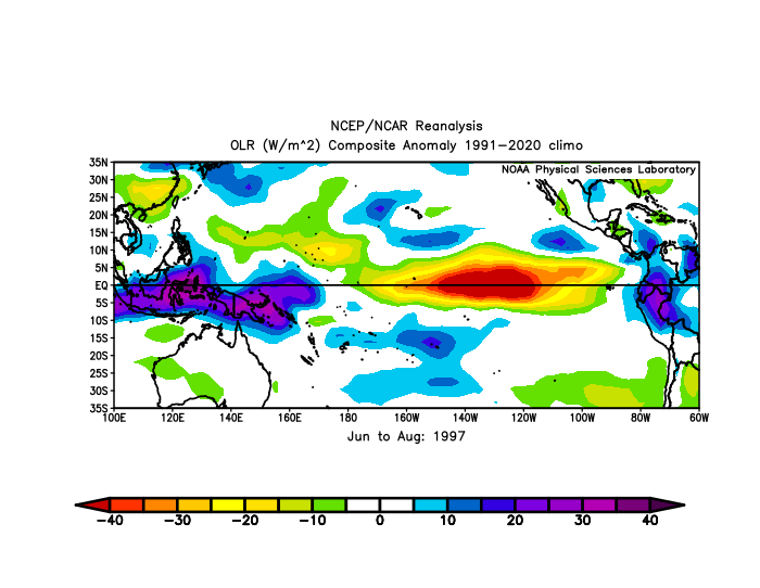
-
 I thought you were exaggerating. It does look bleak.
 -
2026-2027 Super El Nino
LakePaste25 replied to Stormchaserchuck1's topic in Weather Forecasting and Discussion
Yeah, I mean some of this is just noise from TCs. W pac basin was also active in 1997. Just not ready to blame it on this because nearly the entire N PAC basin has seen above normal heights outside the subtropics. We will see. I really want to see where we are at by September. It does seem TCs out there are forming a bit west of 1997.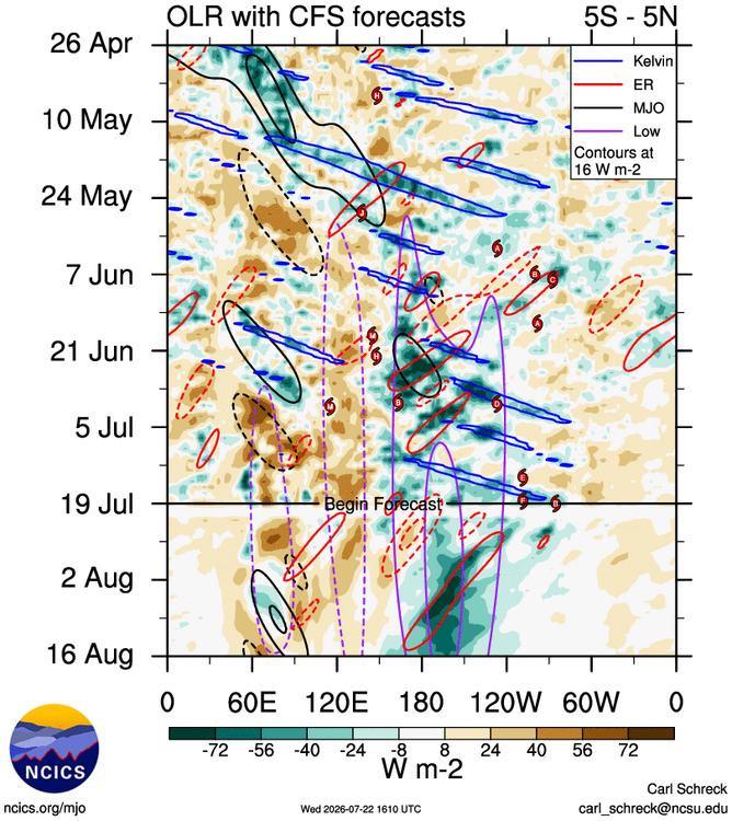
-
Better not.
-

2026-2027 Super El Nino
40/70 Benchmark replied to Stormchaserchuck1's topic in Weather Forecasting and Discussion
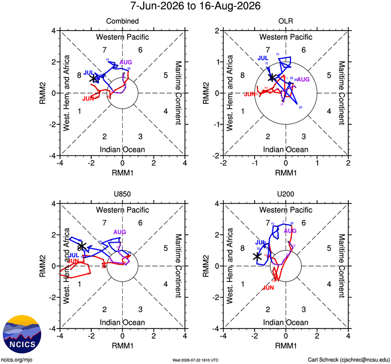
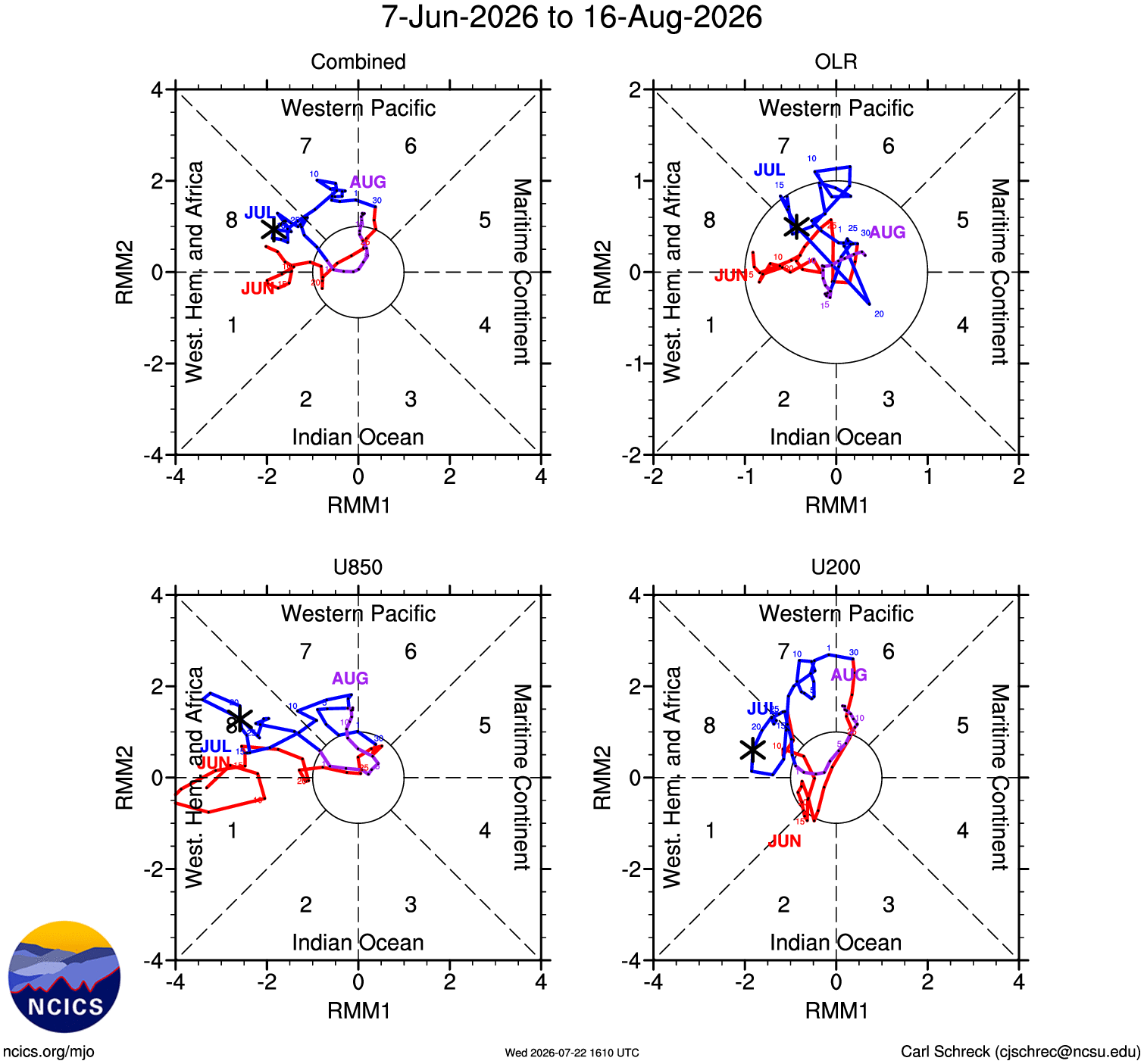
MJO isn't always the best tool because it doesn't show split forcing...check the Homollover (sp?) Anyway, the ridging this month in the NE has not been El Niño like....sure, you could blame the lack of correlation in the summer, but most other developing intense Nino events did not have it, and this one is developing faster. I think it's also important to mix in actual observations with the array or tools. -
 Nope he loves to go fishing. Raised him into a man.
 -
2026-2027 Super El Nino
LakePaste25 replied to Stormchaserchuck1's topic in Weather Forecasting and Discussion
I must be missing something because I don’t see a ton of MC competition. I agree the N Pac is not exhibiting your typical response but I think it could be due to something else.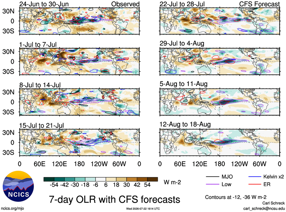
-

Central PA Summer 2026 Discussion/Obs Thread
canderson replied to Voyager's topic in Upstate New York/Pennsylvania
The next five days are going be @Bubbler86 summer chamber days. Low 80s, zero humidity, no rain in sight. -
 When I worked as an observer at MKE, I could see lightning quite a ways south of Chicago sometimes so probably around 130 miles as well.
 -
6 PM LWX Regional Weather Roundup has Frederick reporting a temperature of 102 with a heat index of 104. It may be time to get that thermometer out of the sun.
-
It’s deceiving. I was under 2 showers that seemingly looked meh on radar and got an inch already.
-
2026-2027 Super El Nino
40/70 Benchmark replied to Stormchaserchuck1's topic in Weather Forecasting and Discussion
Yea, both can be true.....Nino is epic in the tropics, but we still have some MC competition in mid latitudes. -
Radar looks pretty anemic, frankly. .
-
We deserve this upcoming weather stretch!
-
 I'm at ~1,200 ft in Burlington CT and twice say lightning flashes over Rutland VT... About 135 miles away.
 -
A cooler regime is in place and will remain in place through the remainder of July. Highs will generally reach the lower 80s through much or all of the remainder of July. The warmest spots could reach the middle 80s on occasion. The ENSO Region 1+2 anomaly was +3.6°C and the Region 3.4 anomaly was +2.1°C for the week centered around July 15. For the past six weeks, the ENSO Region 1+2 anomaly has averaged +3.20°C and the ENSO Region 3.4 anomaly has averaged +1.82°C. The ongoing strong El Niño will continue to strengthen through the summer. The SOI was -17.36 yesterday. The preliminary Arctic Oscillation (AO) was -0.144 today. Based on sensitivity analysis applied to the latest guidance, there is an implied near 72% probability that New York City will have a cooler than normal July (1991-2020 normal). July will likely finish with a mean temperature near 76.6° (0.9° below normal). Supplemental Information: The projected mean would be 0.1° above the 1981-2010 normal monthly value.
-
It'd be funny if Judah Cohen comes up with an index to correlate forest fire smoke to a snowy and cold winter.
-
The next 4 days look incredible. Time to turn off the AC for a few days
-
Don't you worry, the snow line will stay firmly north of the mason Nixon line all winter long
- Today
-
Agreed, lol I am in favor of them just standing pat or perhaps consider Rogers and Ward for trade. To me we are not going to get anything for Adley that will help the organization anytime soon--and the injuries are only gonna lessen the package, imo I mean for your former 1:1 it better be in your Top 5 prospects and that's just a start.
-
A beautiful evening to see a free Fleetwood Mac knockoff band at Wisp. 70 with a breeze - heading to the upper 40s tonight. Yes please and thank you.
-
Can already feel a significant difference in the air.
-
-
 Did daddy-o @CoastalWx lock you out of your house again?










.thumb.JPG.418e8a9a2902ae687ec35ff4bc0e038e.JPG)