All Activity
- Past hour
-

Central PA Spring 2026 Discussion/Obs Thread
Jns2183 replied to Voyager's topic in Upstate New York/Pennsylvania
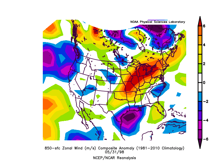
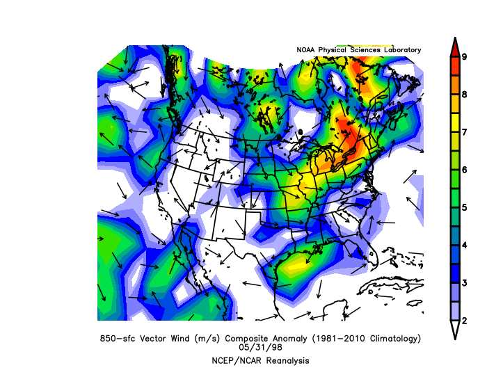
The old two mile wide long track ef4 going over the absolute most mountainous terrain in Pennsylvania like it was Alabama. If you ever get a chance to go look at some of the re-analysis anamoly for that day in a zoomed in fashion. The amount of absolute bonger values you get actually would almost make that tornado feel inevitable. It's that storm and the ef3 plus damage they found on mountains out west above 10000 feet that makes me laugh when people say they're safe because of the terrain they're in. Sent from my SM-S731U using Tapatalk

-
Avery-Madison-Yancey-Mitchell-Swain-Haywood-Graham- Including the cities of Banner Elk, Newland, and Faust 156 AM EDT Mon Mar 16 2026 ...WINTER WEATHER ADVISORY IN EFFECT FROM 1 PM THIS AFTERNOON TO 3 AM EDT TUESDAY ABOVE 3500 FEET... * WHAT...Snow expected above 3500 feet. Total snow accumulations up to 3 inches. Higher amounts in the elevations above 5000 feet. A dusting to possibly an inch in some lower elevation locations. Winds gusting as high as 55 mph. * WHERE...The North Carolina mountain counties along the Tennessee border above 3500 feet. * WHEN...From 1 PM this afternoon to 3 AM EDT Tuesday.
-
 I’ve got a decent setup in my truck, but this thing is going to be moving so fast - the terrain / congestion and roads around northern VA make it almost impossible to follow something like this. If there’s a specific portion of the line that’s repeatedly tornado-warned or has a decent velocity couplet, I might try to position myself in that general area… but I don’t think I’ll be “chasing” anything really. Might not even matter as I can’t get out of work early regardless.
 -
 No such thing as a slam dunk in our neck of the woods. Will be interesting to see what today brings. It’ll be a fascinating meteorological evolution. Chasers—ALWAYS have multiple escape routes, and don’t hesitate to bail if you feel like something’s not right. Be safe, everyone.
 -
due south of you, but well south, along i-88.
-
.thumb.jpg.6a4895b2a43f87359e4e7d04a6fa0d14.jpg)
Central PA Spring 2026 Discussion/Obs Thread
Yardstickgozinya replied to Voyager's topic in Upstate New York/Pennsylvania
Starting to see initiation of a fleet of cells out ahead of the front in Alabama at 2:00AM probably not good situation.
-
I’m hopeful ATL can stay out of big trouble based largely on the lucky timing of the worst coming through in the very wee hours. @buckeyefan1Would you please pin this til the threat passes? TIA
- Today
-
Central PA Spring 2026 Discussion/Obs Thread
Yardstickgozinya replied to Voyager's topic in Upstate New York/Pennsylvania
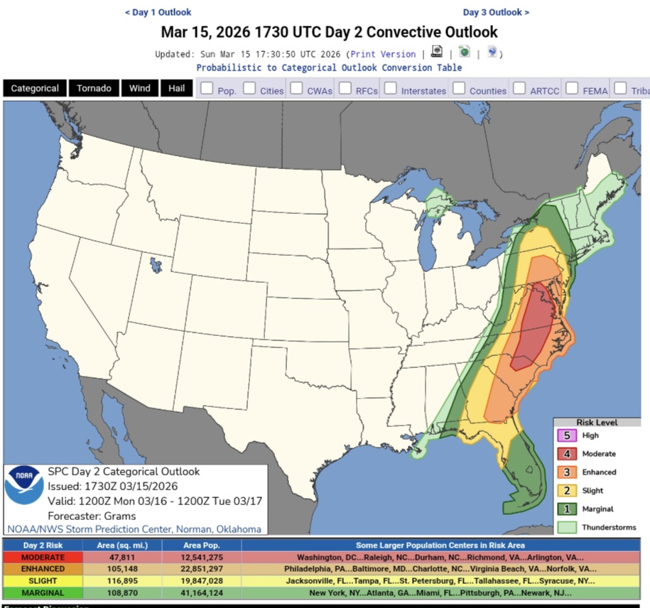
12:30pm SPC update. Not a whole lot of change. https://www.spc.noaa.gov/products/outlook/day2otlk.html
-
 Oh, absolutely. The ceiling for this event is way higher than we usually see around here. I’m just pointing out that we shouldn’t be shocked if this ends up way short of its potential. The 00z CAM suite was far from a slam dunk.
- 265 replies
-
- 2
-

-
- severe
- thunderstorms
- (and 1 more)
-
Gotcha glad you stayed safe despite power outage .
-
Reminds me of 4/16/11, besides the instability. Probably a good thing this setup is occurring in March and not April. I chased down in Lumberton that day, saw a weak EF1, but the show was primarily to the north. I do remember the winds were absolutely insane that day, but as eyewall said you basically got one shot at whatever you were chasing.
-
 True... but the text posted above also mentions potential for strong long track tornadoes
 -
It’s still a go in terms of the categories and percentages that they’re rolling with, but the actual text mentions multiple ways this could bust.
-
Day 1 Convective Outlook NWS Storm Prediction Center Norman OK 1226 AM CDT Mon Mar 16 2026 Valid 161200Z - 171200Z ...THERE IS A MODERATE RISK OF SEVERE THUNDERSTORMS THIS AFTERNOON ACROSS PARTS OF CENTRAL MARYLAND...MUCH OF CENTRAL AND EASTERN VIRGINIA...CENTRAL NORTH CAROLINA AND ADJACENT PORTIONS OF SOUTH CAROLINA... ...SUMMARY... Fast moving thunderstorms may become widespread and accompanied by the risk for damaging wind gusts and a few tornadoes across the Mid Atlantic today. There is potential that a couple of storms could become capable of producing strong and long track tornadoes. ...Discussion... Models indicate that large-scale mid-level ridging will maintain amplitude across the Pacific coast through the Canadian Prairies and U.S. Rockies into early Tuesday and beyond. At the same time, it appears that downstream ridging will undergo further amplification just east of the Atlantic Seaboard, with only very slow eastward progression of large-scale troughing in between, across the Mississippi Valley into the Atlantic Seaboard. It does appear that one significant short wave perturbation will gradually pivot through the base of the troughing, toward the Cumberland Plateau during the day today, before rapidly accelerating northward near the Appalachians toward southwestern Quebec this evening through the overnight hours. Models suggest that this will eventually provide support for a rapidly deepening secondary surface cyclone across Quebec, downstream of an occluding and weakening cyclone across the lower Great Lakes vicinity. Surface troughing ahead of the trailing cold front is also forecast to undergo notable deepening to the east of the Allegheny Front and Blue Ridge today, and it appears that a rather sharp surface pressure fall/rise couplet will develop and overspread the northern Mid Atlantic coast late this afternoon and evening with the passage of the trough and trailing cold front. The cold front may clear all the Atlantic Seaboard, but perhaps portions of southern Florida and the Keys, by 12Z Tuesday. ...Atlantic Seaboard... Low-level moisture return is underway across the southern into middle Atlantic Seaboard. By early this afternoon, it appears that 60+ F surface dew points will advect as far north as the higher terrain of central through northeastern Pennsylvania, with dew points perhaps as high as the lower/mid 60s F across eastern North Carolina and Virginia. In advance of a pre-frontal squall line, which may be ongoing and beginning to spread to the lee of the southern Appalachians through the eastern Gulf Coast states at the outset of the period, it appears that destabilization and large-scale ascent may support scattered new thunderstorm development fairly early in the day. The extent to which this may impact further destabilization through late afternoon remains unclear. Destabilization may also be impacted by relatively warm air/weak lapse rates in mid/upper-levels, as models suggest that cold air aloft will tend to lag to the west of the surface cold front. Even so, forecast soundings suggest that, with breaks in the overcast, at least weak boundary-layer CAPE on the order of 500-1000 J/kg is possible in the warm sector across the Mid Atlantic. In the presence of very strong southwesterly deep-layer mean flow on the order of 50-60+ kt and strong to extreme low-level shear, including at least modest clockwise curvature, the environment appears potentially conducive to the evolution fast moving supercells with potential to produce strong tornadoes. Barring much interference from other storms, which remains uncertain at this time, at least a couple of these could become long track, given the storm motions. Otherwise, trailing this activity, the lee surface trough/cold front might become a focus for a developing line of storms capable of promoting the downward transfer of momentum with potential to produce widespread damaging wind gusts. Farther south, it appears that the initial squall line may be maintained or re-intensify, with a continuing risk for strong to severe wind gusts and potential for tornadoes into and across the southern Atlantic coast. ..Kerr/Thornton.. 03/16/2026
-
They canceled school in VA because of it. I'm thinking kids are probably safer in a large building than a house if a tornado hits. Then a second thought hits my mind, the county doesn't want to be responsible if a tornado hits the school.
-

Central PA Spring 2026 Discussion/Obs Thread
MAG5035 replied to Voyager's topic in Upstate New York/Pennsylvania
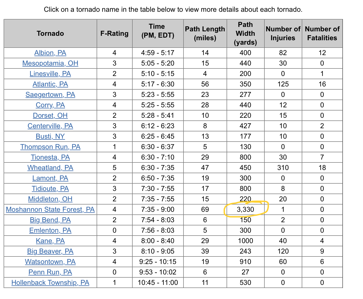
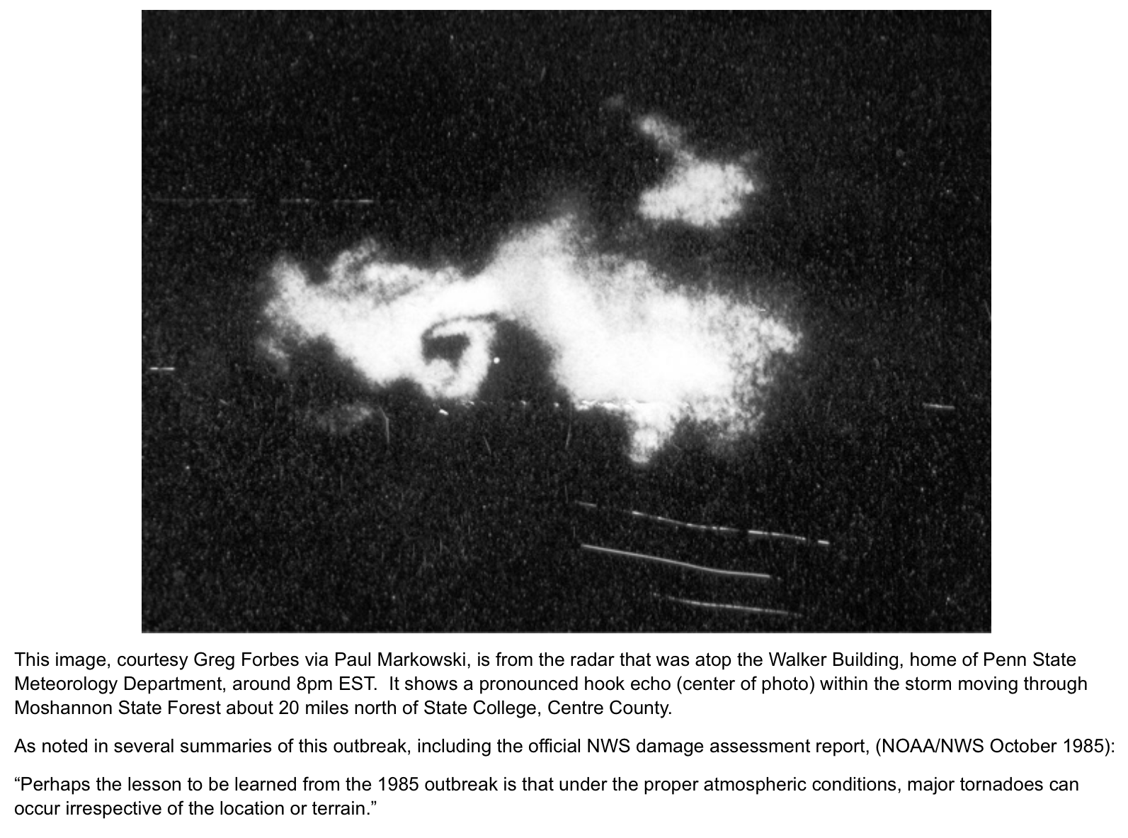
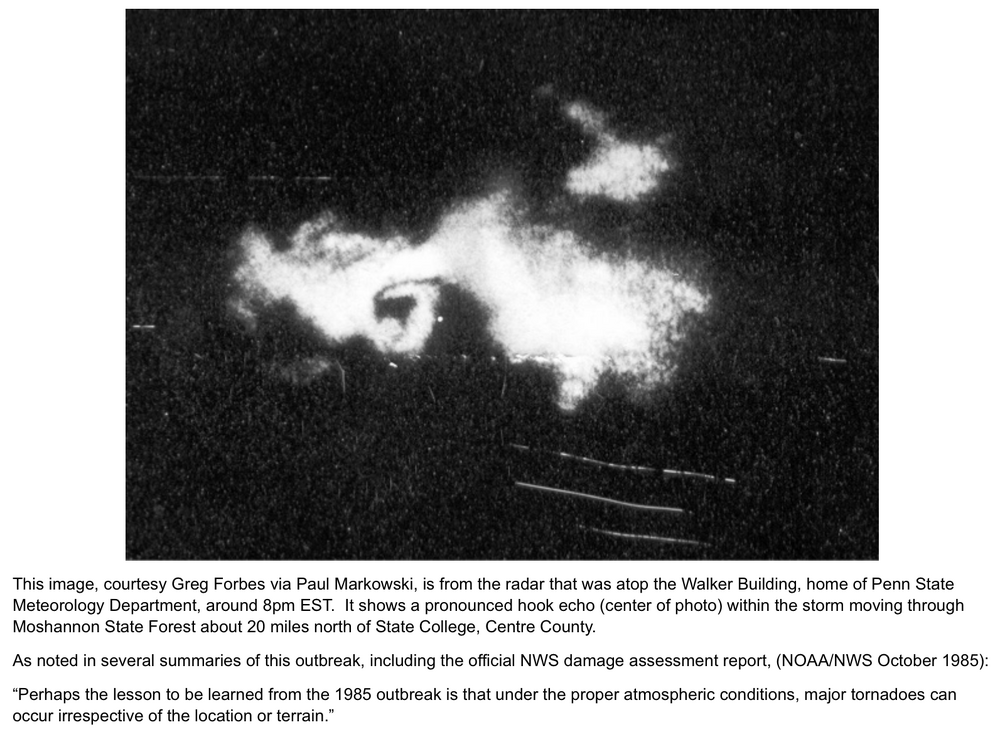
The May 31st, 1985 tornado outbreak was more severe and remarkable than 1998 or any other more recent PA involved outbreak by a pretty sizeable margin. That outbreak spun up 43 tornadoes and killed 89 people (1000 injured) in PA, NY, OH and Ontario (65 alone in PA), produced PA’s only ever EF5 tornado (Wheatland), and also produced what I’m pretty sure was one of the widest tornadoes ever recorded in the US at the time (Moshannon State Forest). Couple screen grabs below but there’s some really informative links about this outbreak CTP’s 35th anniversary link- https://www.weather.gov/ctp/TornadoOutbreak_may311985 New interactive link they made for the 40th anniversary last year collaborated with NWS Pittsburgh, State College, Buffalo, and Cleveland https://storymaps.arcgis.com/stories/e8c12f670d5648a9b64877f42660eeeb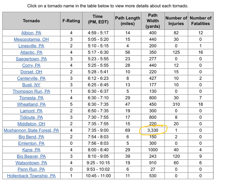
-
Yea the warm layer didnt fully make it to my area as forcasted, lucky for us bad for m72 - m55 they are getting hit hard. I know the pain all to well from last year almost exactly a year ago.
-
Aren’t you SE of me?
-
Extreme Heat Warning, Blizzard Warning, Tornado Warning, Severe Thunderstorm Warning, Winter Storm Warning, High Wind Warning, Flood Warning, Ice Storm Warning, Freeze Warning, Gale Warning, Red Flag Warning, Storm Warning (purple in the western Gulf), Lake Shore Flood Warning, Special Marine Warning, Heavy Freezing Spray Warning all in effect in the U.S currently. Maybe the wildest weather night ever. I think the only weather warnings that aren't currently active are Tropical Storm, Hurricane, Extreme Cold, Coastal Flood, and a Flash Flood.
-
Flipped fully over to snow now, with about a 1/2" down.
-
The biggest issue here is that it’s still very much a snow and sleet combo.
-
 NWS forecast for Phoenix.. their all time March high on record was March 26, 1988, 100F. They have only hit 100 once in March (someone correct me if I'm wrong, that's what I've seen other people post). Wednesday Sunny, with a high near 102. Thursday Sunny, with a high near 105. Friday Sunny, with a high near 107. Saturday Sunny, with a high near 106. Sunday Mostly sunny, with a high near 103.