All Activity
- Past hour
-

Central PA Winter 25/26 Discussion and Obs
Itstrainingtime replied to MAG5035's topic in Upstate New York/Pennsylvania
This is from my weather notebook: I measured 8.8" just south of Mountville here in Lancaster county. Rain began on Monday night, April 5th with temps in the low 40s and by daybreak on the 6th I had heavy snow and very strong winds which created true blizzard conditions. The 8.8" of snow fell in a 7 hour period as temps crashed into the mid 20s. We missed 2 full days of school and had a 2 hour delay on the 3rd day after the event. Winds were measured at over 50 mph in the county. Dad said we never had anything like that before in April during his lifetime and that I would never see it again. 43 years later, he's still right. Here's the snow map. I was just inside the southern edge of the good stuff. Hard to believe based on this that you didn't do better. It wasn't an elevation dependent storm, temps were in the 20s throughout the snow portion. -
High-level clouds mostly obscuring the sun. Waiting for the bright sunshine NWS promises.
-
But that means of course that anyone wanting to see the 0Z Euro before bedtime has to stay up an extra hour. I’m not looking forward to that and all of the runs of models coming out an hour later. I like the GFS starting to roll at 10:30 instead of 11:30 AM/PM. The MJO and teleconnection indices also come out an hour later.
-
Generally in coastals further east and northeast does better than Seekonk. Better proximity to ocean.
-

February 2026 OBS & Discussion
WeatherGeek2025 replied to Stormlover74's topic in New York City Metro

-
Meant meh.
-
Huh?
-
I would have rather hit the cold phases of the MJO now since its still early and delay the warmth to April (obviously the temps would be higher then). Now we are going to have some warmth in March at the expense of April.
-

"Don’t do it" 2026 Blizzard obs, updates and pictures.
Ginx snewx replied to Ginx snewx's topic in New England
Um why am I at 4.8 -
Yeah overall, 2022 was the first time this area jacked since 2005, and before that 1996. So it really doesn't happen all that frequently like many people think. Going by PVD records, the top five are 2026, 1978, 1996, 2005, and 2022. Outside of those, we have done good in several like you said but nothing S tier like out west. Jan 2011, Feb 2013, Jan 2015, Feb 2017, and Jan 2018 all dropped over a foot here, but then between Jan 2022 and Jan 2026 we got barely anything at all. People say it's always SEMA but we've been screwed over for a long time too, and Rhode Island in particular! I remember for many years it seemed like every major storm had the entire state in a snow hole. 2022 and 2026 was their redemption I guess.
-
I passed an accident in the densest fog area but it had happened long enough before that police were already on site. But wouldn’t doubt visibility was a factor. Temp was below freezing.
-
"Don’t do it" 2026 Blizzard obs, updates and pictures.
Ginx snewx replied to Ginx snewx's topic in New England
Jesus I can only upload 4.8 mb and am constantly deleting images to stay below the 195mb total. So 2 cat 3/4 in 1 year. Never seen it here before -
This was the storm that brought a blow down to SNH down to NE MA. I know everyone is focused on snow, but they had 70-90mph winds from Cape Ann to srn coastal ME.
-
A week and 2 days till daylight saving time.
-

Central PA Winter 25/26 Discussion and Obs
Mount Joy Snowman replied to MAG5035's topic in Upstate New York/Pennsylvania
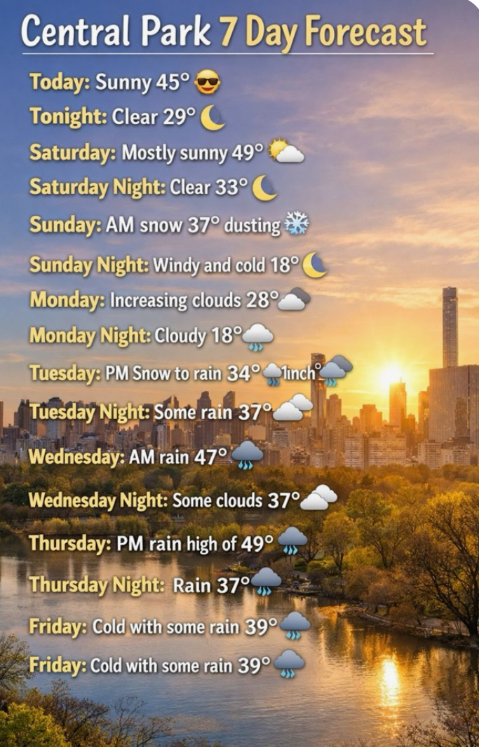
Low of 26 and foggy, freezing fog dare I say. Not sure what to make of early next week as it's kind of a mess as depicted but it does not appear as if any type of significant snow event is in the cards for us. Then we get wet and warm through mid-month. After that, who knows, continual spring or winter's last stand? Stay tuned. Happy Friday, all. -

"Don’t do it" 2026 Blizzard obs, updates and pictures.
dendrite replied to Ginx snewx's topic in New England
Looks like the first 12” or so down there was on the more moist/dense side before winds backed to 020? Beyond that, I’m not going to pretend to know what it’s like to experience 4”/hr with a 40-50kt wind. I would think in theory the dendritic structure takes a mechanical beating, but when it’s snowing that hard I can imagine it almost accumulating too fast for the wind to entirely mess with. But I’m up in CAD land where the snow prefers to fall and land gently. I had barely any wind in my 34” in 12hrs in Dec 2020. I think you could’ve sneezed on the pack and knocked it down 5”. -

"Don’t do it" 2026 Blizzard obs, updates and pictures.
tamarack replied to Ginx snewx's topic in New England
Thanks. "OV (Ohio Valley) Blizzard = CLE Superbomb. Sorry for the confusion. The 2/2/76 event caused a mega-tidal surge up the Penobscot estuary, and the water at BGR rose 15 feet in 15 minutes, drowning about 200 cars in the Kenduskeag Plaza parking lots. -

E PA/NJ/DE Spring 2026 Obs/Discussion
JTA66 replied to PhiEaglesfan712's topic in Philadelphia Region
We need the rain, but I wouldn't mind a mild, dry March so I can do yard clean up before mowing season gets underway. -
Heavy frost but bright sunshine.
-
Exactly. Cold in March is useless 99% of the time. A cold spell in late March isn't going to yield some 1888 blizzard lol. It's going to be 45 degrees and miserable. After March 15th I root for warmth.
-
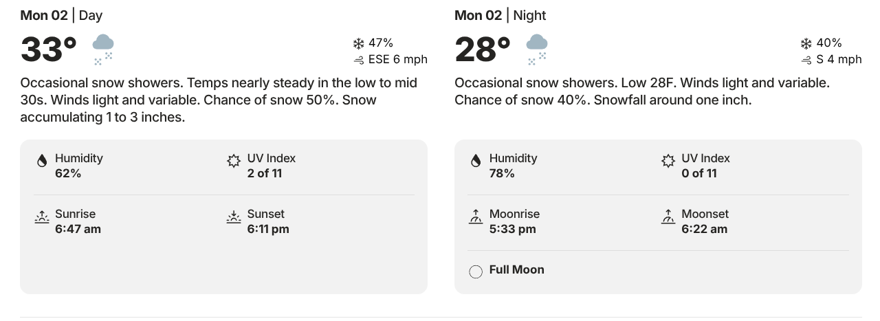
It snowed 3-4”/hr+ for 9 hrs only to yield 13”
-
He’s had a rough winter and has become a curmudgeon. We always had fun with him, but his approval rating is way down this season. Hopefully next year we can make accordionists great again.
-
Bacon Ridge trailhead on Forny RD has 300 acres of wild meadows. I threw out 20 pounds of native wildflower mix on the public lands there. It's absolutely awesome. I go there every evening during the spring and summer to just look at wildflowers.
-

Outta gas and Outta Time: Early March Winter Storm finale
WesternFringe replied to Ji's topic in Mid Atlantic
To each his own, but why stop in this storm thread just to say that? Why not leave us the hell alone if you aren't interested rather than pissing in our corn flakes? ...mind blowing lol A day off from work with my family and this forecast seems like a good way to wrap up winter to me!
-
Freezing fog in New Windsor this morning. Was very slick on an early morning EMS run near Taneytown at 3:00 am.