All Activity
- Past hour
-


-

January 2026 regional war/obs/disco thread
SnoSki14 replied to Baroclinic Zone's topic in New England
I'm very cautious about a huge snowy pattern but even I recognize this post as BS. How in the world do the ensembles look like trash 240+ If anything they're showing a rising PNA ridge. I think this post is just as deluded as the social media weenie blizzard posts from JB -
Sometimes guidance can correctly latch onto big cold blasts or warmups far in the distance. I remember how well the January 2019 cold blast and early February 2019 cold blast was forecast. Got down to near 0 here in NYC. Down near -30 in Chicago. Very impressive cold blasts that winter
-

January 2026 regional war/obs/disco thread
WinterWolf replied to Baroclinic Zone's topic in New England
I think you told us this last one , on Friday night(12/26), wasn’t gonna be anything at all..,and as I said to you then, then that pretty much guarantees us a hit. And low and behold…we score with 8-10”. This too should guarantee another good hit. You sir, may not be the dumbest person in the world, but you better hope the dumbest person doesn’t die. -
Ji has already canceled next winter. He's never satisfied with anything. IIRC, he was dismal in Jan 2010.
-
CAD doing its magic in NC! I’m jealous of you caddies. Consider that here it is still 70.8 here (with overcast). But even this is better than high 70s with sunny 24 hours ago and better than earlier this afternoon. This contrast between GA and NC was forecasted quite well. Yesterday’s high at KSAV was a sweaty record tying 80.
-
Damn. Could they actually win this thing? 2 mins to go. It is the Browns.
-
Wow that's terrible.
-

Ice Ice Baby December 28-29 Storm Discussion
CTSkywarn replied to Baroclinic Zone's topic in New England
Jh -
Euro long range is suggesting a pattern change closer to mid-month as a storm tracks further south and then northeast into our neck of the woods
-

Central PA Winter 25/26 Discussion and Obs
Jns2183 replied to MAG5035's topic in Upstate New York/Pennsylvania
Worst winds here seem to be overnight Monday Sent from my SM-S731U using Tapatalk -

Ice Ice Baby December 28-29 Storm Discussion
dendrite replied to Baroclinic Zone's topic in New England
They bit on the HREF icing. I’m still taking the under. -

Ice Ice Baby December 28-29 Storm Discussion
moneypitmike replied to Baroclinic Zone's topic in New England
One of the shortest lived storm threads evah. -
He is already panicking over an EPO ridge lol.
-
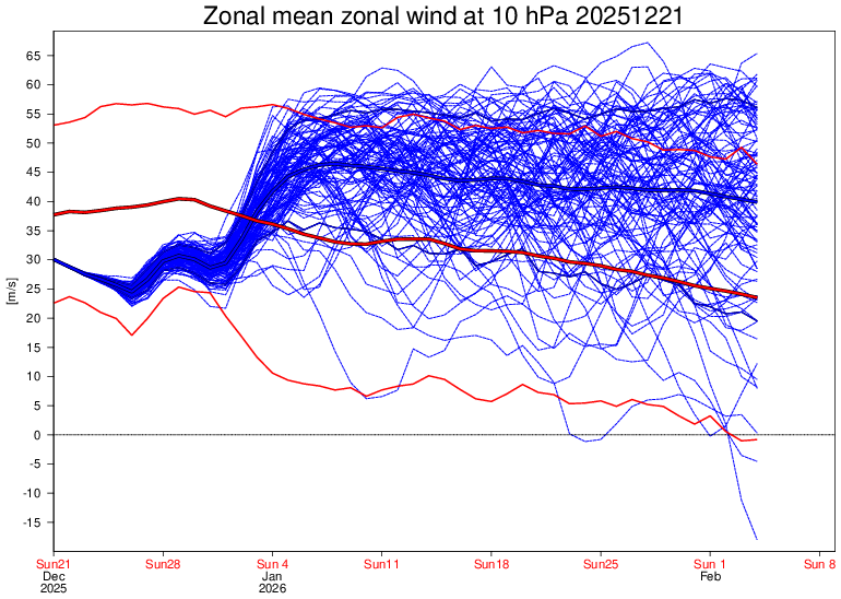
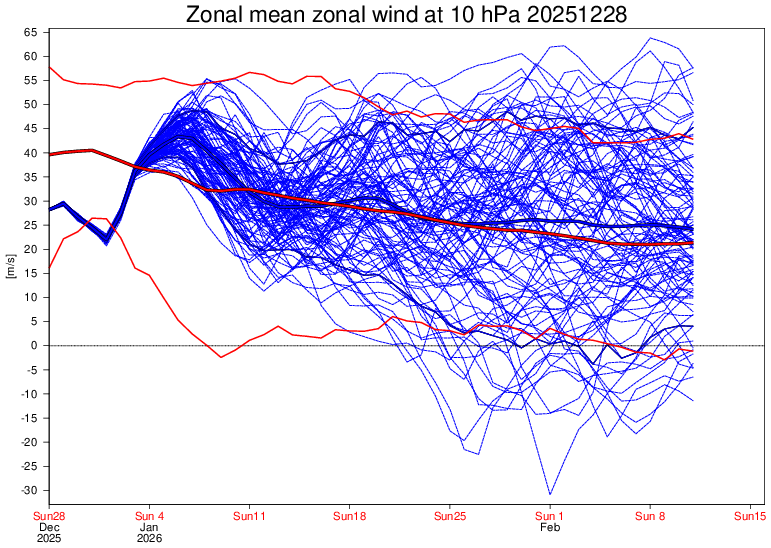
Well, check this out: Look at how much weaker the SPV forecast is at 10 mb based on the 60N mean zonal wind on the Euro Weeklies! One week ago (12/21 run): quite strong just about all Jan through Feb 4th with no end in sight (mean 40-47 m/s): Today (12/28 run): near normal Jan 10th-Feb 11th (mean only 25-35):
-
Ice Ice Baby December 28-29 Storm Discussion
moneypitmike replied to Baroclinic Zone's topic in New England
Color me shocked. -
Let's see what tonight's weeklies say before Ji panics
-
Central PA Winter 25/26 Discussion and Obs
Jns2183 replied to MAG5035's topic in Upstate New York/Pennsylvania
1-2 feet winds guesting up to 55mph Sent from my SM-S731U using Tapatalk -
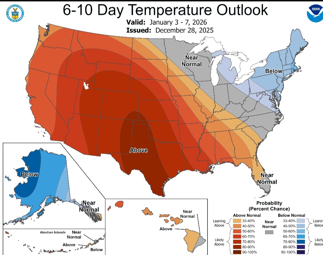
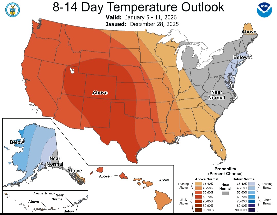
Don't need ABOVE normal precip. Also its a super LR model. How the fuck is it going to accurately depict how many storms might hit a particular region. All we need is a few, and precip can still be below or normal, with normal to above normal snowfall.
-

Ice Ice Baby December 28-29 Storm Discussion
Damage In Tolland replied to Baroclinic Zone's topic in New England
https://x.com/eweather13/status/2005372102115987786?s=46&t=dhcbvkjmRcyBVQtDxJ3lRg -
I am not surprised especially if the polar vortex splits one piece near eastern USA and Canada and the other to Europe.
-
I got a solid 0.47" of rain, which is more than what most models were predicting. The temp has crashed from 43º to 25º just in a few hours.
-
The blizzard of 96' happened in the exact same pattern we'll be in going into 2nd week of January. Just about 30 years to the day.
-
That look has worked out for much of our region quite often in recent winters, but maybe not so much for you ?
-
a few radars from MN/IA