All Activity
- Past hour
-
I was truly shocked how the cold rushed over the Plateau during the day! It was forecast, but seeing is believing. Takes me back to sudden Plains fropa and I loved it! Then Jax's previous post.. If we play our cards right, that's severe weather in mid-November leading up to Thanksgiving depending on timing. Path from SER to BN heights, baring a stupid cap like last week, is severe wx.
-
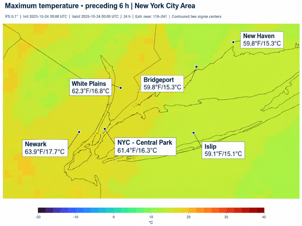
As a further test of the new higher-resolution ECMWF, I pulled the data for today's high temperatures for select NYC area locations. This data is also from the 10/21 0z cycle. It will be interesting to see how things turn out.
-
Congrats Dendrite ! Put it in a smoothie with vanilla high protein yogurt, its really good. Definitely a unique flavor combo. Those fruits look awesome
-
We'll probably get periods of -NAO as the massive tropical warmth pushes poleward and tries to reflect back. However, cold air supply will be a problem. Fighting the PDO could be a problem. I'm still looking for a really mild winter. First for November, if any of these weekly products are even close.. tee up severe leading into Thanksgiving!
-

2026-2027 Record-breaking El Nino
40/70 Benchmark replied to Stormchaserchuck1's topic in Weather Forecasting and Discussion
I think the mid season warming may end up more of a reflection event/CW. -

2026-2027 Record-breaking El Nino
GaWx replied to Stormchaserchuck1's topic in Weather Forecasting and Discussion
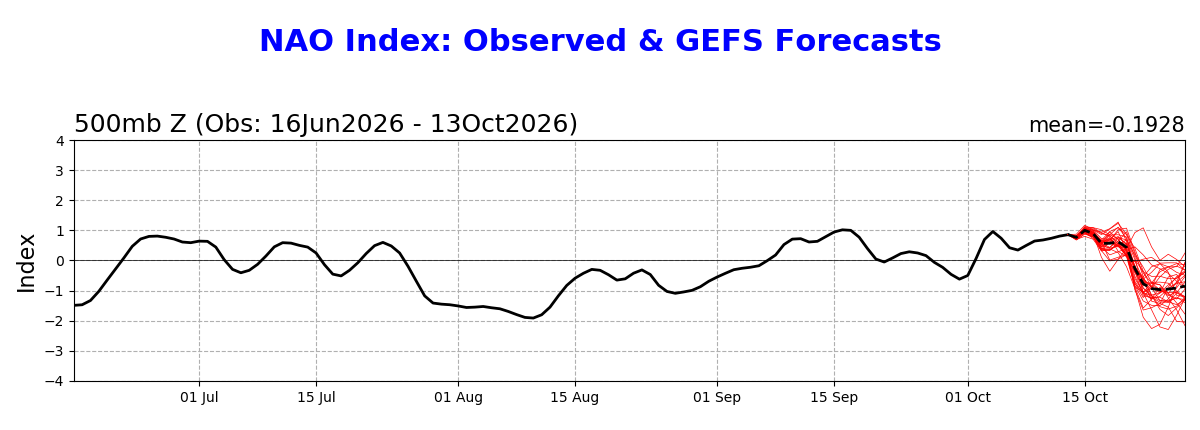
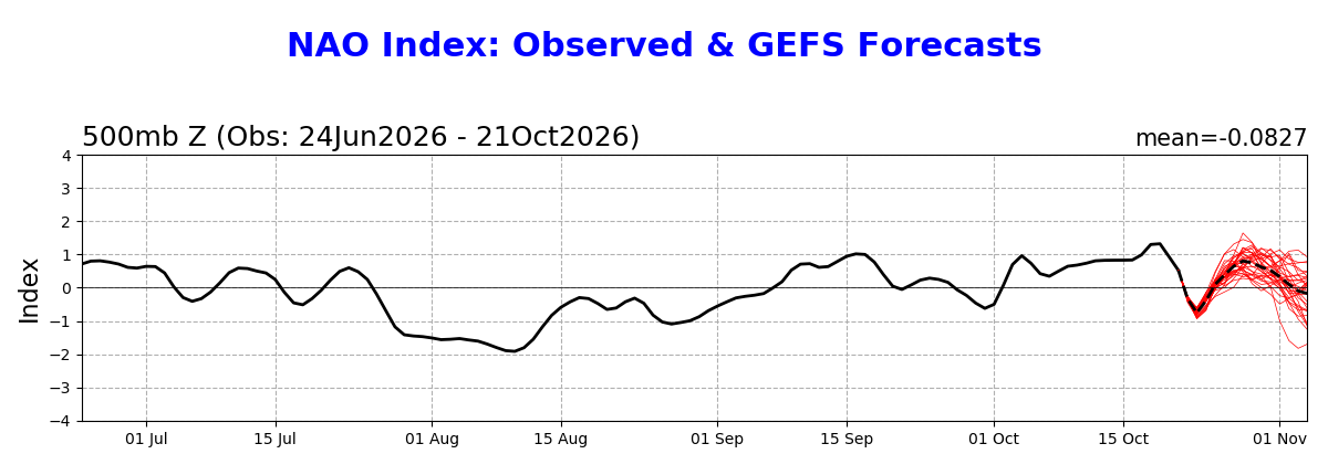
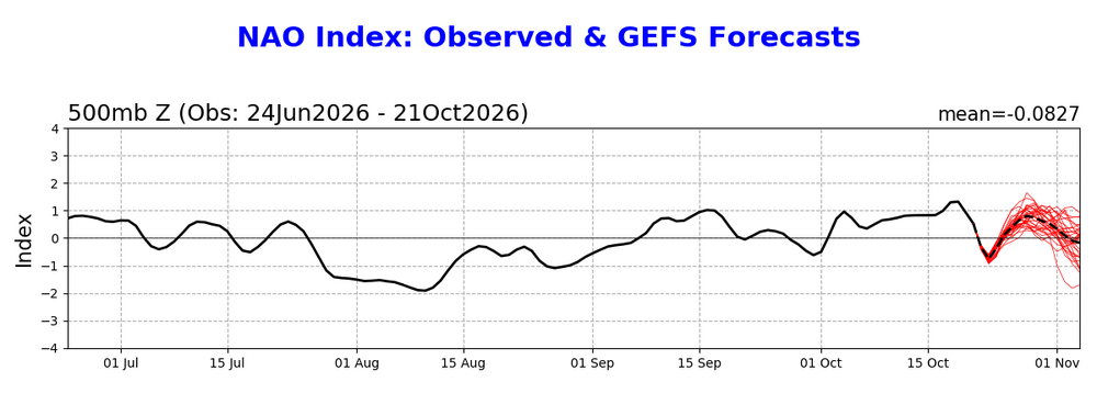
The GEFS NAO prog continues to correct to more positive. Check out how much it has risen over the last 8 forecast days: Oct. 13th fcast mean had it never getting >+1 and that on Oct. 15th with it later down to sub -0.8 for 6 days with it continuing through end of forecast period; It had Oct. 27th down at -0.9: Today’s forecast is so much more positive: it actually peaked way up at +1.73 on Oct 19th and with forecast now dipping only to -0.7 on Oct 22nd followed by a sharp rise to +0.8 on Oct 27th (vs the Oct 13th run having it down at -0.9): Per @Stormchaserchuck1this solidly +NAO in Oct. is actually a good sign if one wants the chance for a -NAO domination in winter to increase. I’m just passing that along as it isn’t my own idea. Forecast models are suggesting a good chance of a -NAO in Feb, regardless. Before that will be tough imho due to at least solar but we’ll see.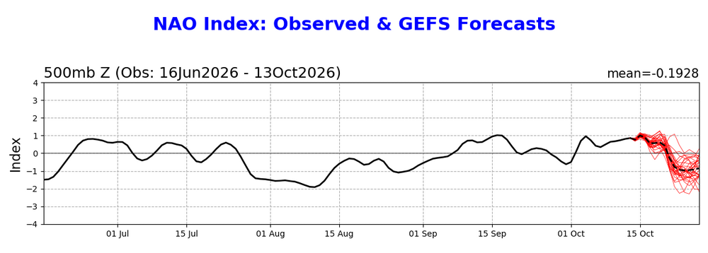
-
Might be the shortest AFD I've read put out by LWX this morning Area Forecast Discussion National Weather Service Baltimore MD/Washington DC 931 AM EDT Wed Oct 21 2026 .WHAT HAS CHANGED... Coastal Flood Advisories issued through Thursday afternoon for an extended period of minor tidal flooding. && .KEY MESSAGES... - 1) Dry conditions and seasonable temperatures are expected through early next week. && .DISCUSSION... KEY MESSAGE 1...Dry conditions and seasonable temperatures are expected through early next week. Surface high pressure continues to build north of the forecast area through the end of the week, yielding dry conditions, seasonal temperatures, and limited cloud cover. High temperatures will be in the 60s to near 70s each day with overnight lows in the 30s to mid 40s. High pressure will build southward out of southeastern Canada and eastern Great Lakes region Saturday through Tuesday. Dry conditions are expected each day. There could be some areas of frost Saturday morning. Temperatures will start out chilly Saturday with highs 5 to 7 degrees below average and highs generally in the upper 50s to lower 60s. By Sunday, temperatures will be more seasonable. Monday will encounter highs approaching or reaching the 70 degree mark. By Tuesday, temperatures may be knocked down to seasonable once again. Highs in the middle 60s.
-
2026-2027 Record-breaking El Nino
40/70 Benchmark replied to Stormchaserchuck1's topic in Weather Forecasting and Discussion
The new Adam is such a breath of fresh air...I wish Forky would take a break for a couple of months. -
Don't worry, they still look the same.
-
2026-2027 Record-breaking El Nino
40/70 Benchmark replied to Stormchaserchuck1's topic in Weather Forecasting and Discussion
You managed to inadvertently elicit one last sneak preview of my favorable window this winter before I go radio-silent to work.....WATCH THE GRADIENT BETWEEN THE KUROSHIO CURRENT AND KONA LOW OUT IN THE PACIFIC CONTINUE TO GROW -
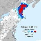
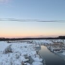
Wow! 12" in 1969. We had 5" that ended as zr just south of BWI. But it was great nonetheless. I remember it well. (at my age, remembering 57 years ago is easy....it's 57 minutes ago that's the problem )
-
2026-2027 Record-breaking El Nino
LakePaste25 replied to Stormchaserchuck1's topic in Weather Forecasting and Discussion
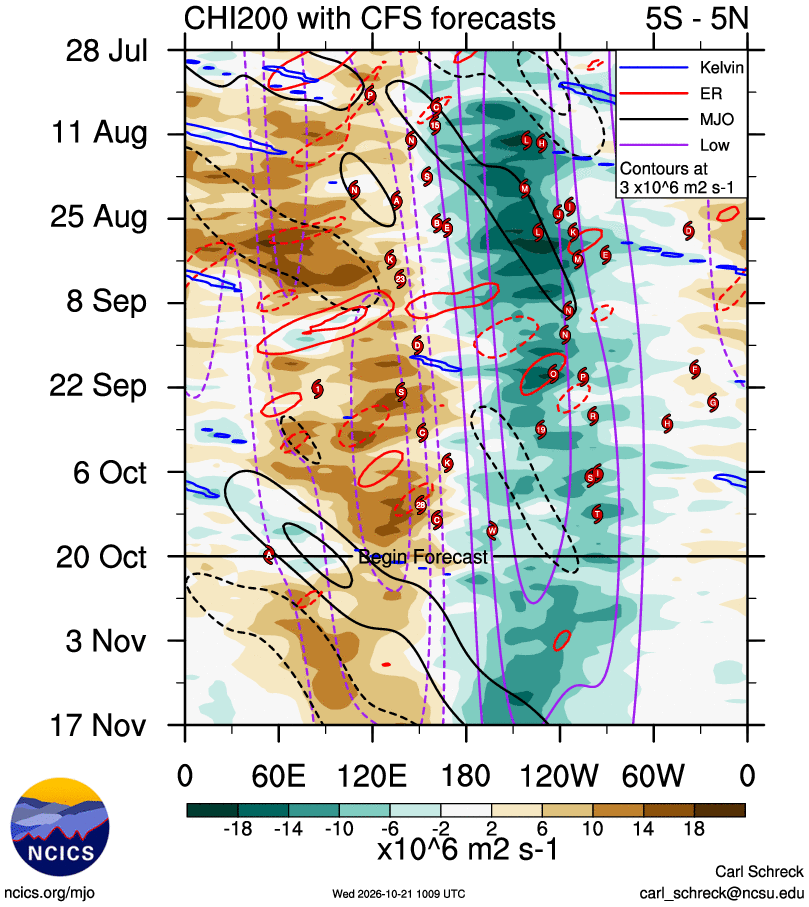
Can see where the MJO is heading (solid black loop). By mid month it’ll enter 6-7-8 and constructively interfere. This mid month period is when we should really watch whether we start to see a full blown N Pacific wintertime nino pattern show up on the ensembles. On a side note, i highly recommend this site (https://ncics.org/portfolio/monitor/mjo/) for MJO tracking this season because the RMM plots won’t be much help due to the sheer magnitude of the Nino signal overwhelming the RMM mean.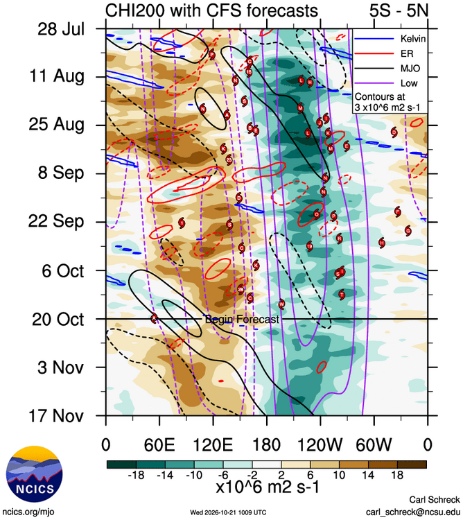
-
2026-2027 Record-breaking El Nino
40/70 Benchmark replied to Stormchaserchuck1's topic in Weather Forecasting and Discussion
More like Greg Oden up here. -
2026-2027 Record-breaking El Nino
GaWx replied to Stormchaserchuck1's topic in Weather Forecasting and Discussion
Absolutely that can happen with how E based it is progged to be! This is especially the case for Feb as the CFS has been showing. I’m expecting a very mild Dec and a mild to NN first half of Jan. Then the fun times could really get going starting late in Jan and especially in Feb and possibly continuing through early March. -
2026-2027 Record-breaking El Nino
40/70 Benchmark replied to Stormchaserchuck1's topic in Weather Forecasting and Discussion
This. -
https://www.easternmassweather.net/2026/10/el-nino-grows-historically-powerful.html
-
2026-2027 Record-breaking El Nino
40/70 Benchmark replied to Stormchaserchuck1's topic in Weather Forecasting and Discussion
https://www.easternmassweather.net/2026/10/el-nino-grows-historically-powerful.html -
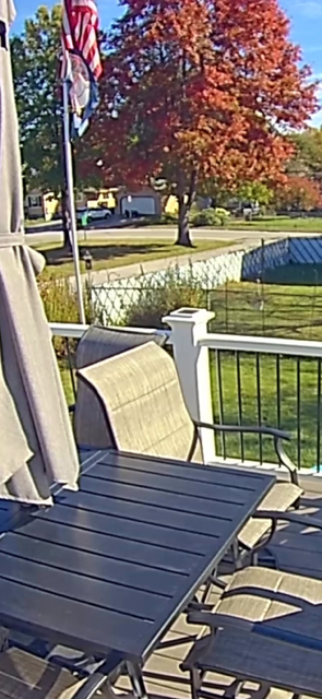
Tom, That first pin has a bit more color then the last several years, The one to the left is still mostly green, Genearlly they end up pretty dull reddish/brown and go to brown and hang on to most of the leaves until spring.
-
2026-2027 Record-breaking El Nino
LakePaste25 replied to Stormchaserchuck1's topic in Weather Forecasting and Discussion
Hence my post about it being “somewhere between the Upper Midwest and Northeast.” A wet coastal pattern doesn’t preclude this happening elsewhere especially the upper midwest, and that region is so cold that they don’t need 60s and 70s to do that. - Today
-
The 1960'S was a "wild and woolly" decade !!! 3 Christmas Day snowstorms. 1962 6 inches, 1966 6", 1969 12" It hasn't happened since.
-
Two trees we have in the front yard had some amazing vibrant colors...mostly yellows. Both the trees though have pretty much dropped all their leaves. One I think has fully dropped and the other like 90% dropped. I don't really know tree species but its interesting because these are legit the only two trees in the neighborhood which have not only fully changed but dropped leaves.
-
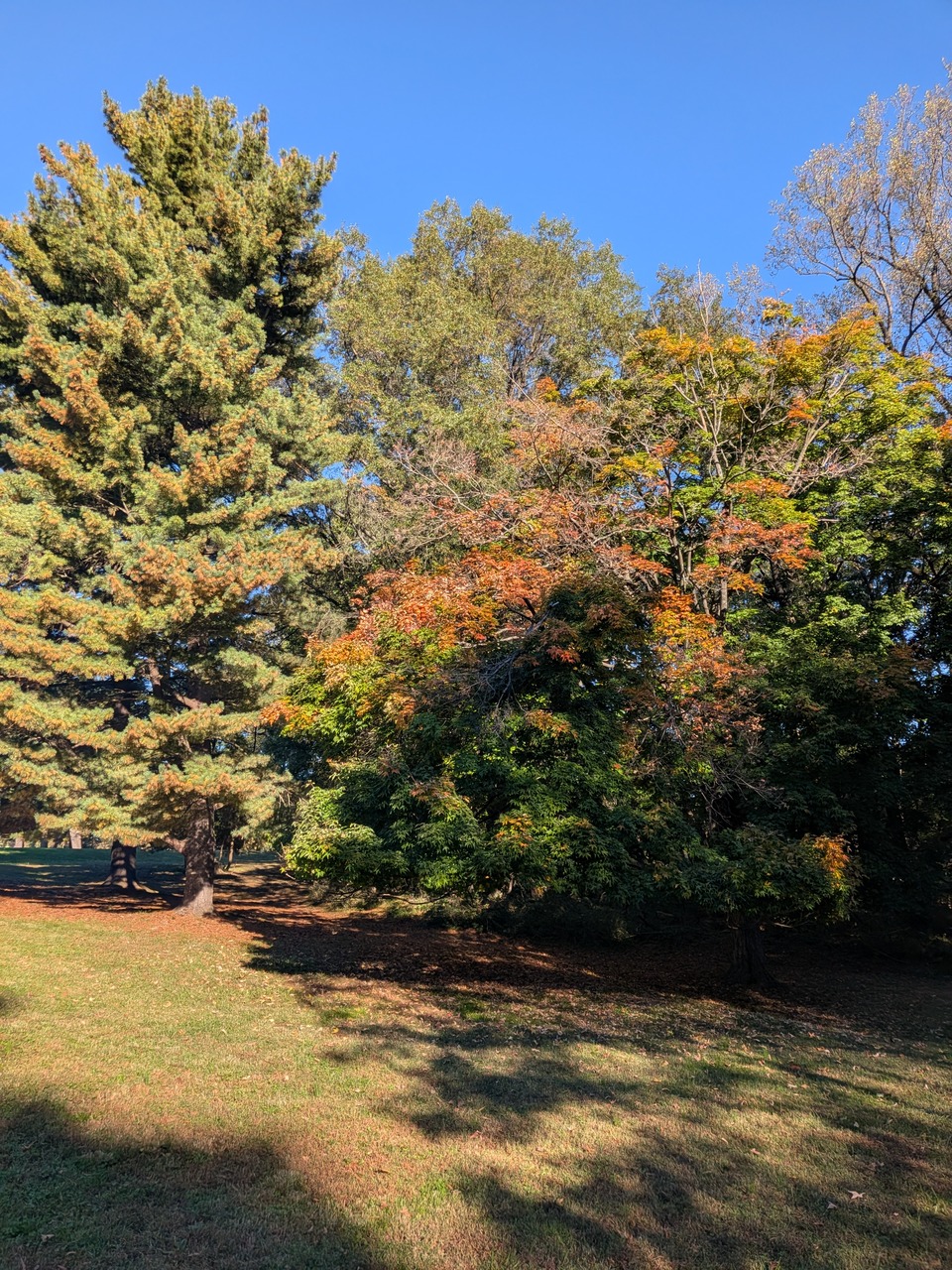
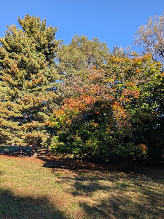
I did not see a thread for this, so, here we go. As of 10/21 along the fall line in lower Montgomery County near DC, we are still mostly green. Maples are changing color but not yet peaking. Poplars really got roasted by the mini-drought and lost a lot of leaves or are brown/crispy (they're yellow in good years). Oaks are still mostly green. Here's a sweet gum tree in a local park that is usually vibrantly red and orange but this year is more muted. The white pines are entering full needle drop around the area, too. Photo taken quickly and carelessly on my smartphone. Post your foliage pics and reports here!
-
2026-2027 Record-breaking El Nino
BlizzardWx replied to Stormchaserchuck1's topic in Weather Forecasting and Discussion
What could be interesting is if el nino forcing indeed is summarily shoved eastward could the typical warm anomaly that sits over the Great Lakes be pushed far enough east that we get more cold air into the US like the CFS is showing? We could also get the moisture from having an active storm track into the south like you would expect in strong el nino. So I am not saying I am buying it, but just wondering out loud on what it will actually mean. Does shifting the forcing east linearly shift the pattern? That isn't always the case either. -

2026-2027 Record-breaking El Nino
Keith Central PA replied to Stormchaserchuck1's topic in Weather Forecasting and Discussion
If you look at December 2015..it was a dry month, which I doubt it will be this year..There was just a few days below normal...several days in the 60's and 70's. That's really extreme if you ask me. -
Weather and step down has been superb…picture perfect autumn so far. Last year was good also.