All Activity
- Past hour
-
18z ICON has a pretty big ice storm here.. ill take that if it happens
-
Some people are going to be mad on Saturday. 30 degrees differences with about 100 miles
-
Got the 2 big storms this year (we also missed 2). That's what was missing last year it was all nickel and dime events
-

Outta gas and Outta Time: Early March Winter Storm finale
Imgoinhungry replied to Ji's topic in Mid Atlantic
Will this impact pm commute Monday and am commute on Tuesday? Or mostly a nothing burger? . -
18-19" still IMBY....stunned it was only down 4-5" this week. Must be a function of that fact that a higher percentage of my snow is old, crusty pack BC I hardly got shit from the blizzard.
-
Remember that month of May, over half dozen years ago that it rained (and was cool) every day in May? During the cool, wet spell, I potted up my young tomatoes, peppers, and eggplants and kept them in the back of my van, worked like a greenhouse. lol
-

Outta gas and Outta Time: Early March Winter Storm finale
LeesburgWx replied to Ji's topic in Mid Atlantic
Have not looked at this thread in 2 days and this is the most recent post! -

Central PA Spring 2026 Discussion/Obs Thread
Voyager posted a topic in Upstate New York/Pennsylvania
Who better than the resident warmanista to start our spring thread? Just please don't me... -
Impressive weather records!
-
push this
-

Central PA Winter 25/26 Discussion and Obs
Blizzard of 93 replied to MAG5035's topic in Upstate New York/Pennsylvania
18z GFS just increased snow amounts a bit for the LSV for Tuesday am.


-

Late February/Early March 2026 Mid-Long Range
stormtracker replied to WxUSAF's topic in Mid Atlantic
Bring it home man. To hell with this talk of wanting sustained warmth. It ain’t over till it’s over. Can’t believe people punting in viable winter time. -
Outta gas and Outta Time: Early March Winter Storm finale
stormtracker replied to Ji's topic in Mid Atlantic
We back! -

Outta gas and Outta Time: Early March Winter Storm finale
Weather Will replied to Ji's topic in Mid Atlantic
WB 18Z RGEM
-
18Z GFS looks like it will have a better cold push..
-

Outta gas and Outta Time: Early March Winter Storm finale
Chris78 replied to Ji's topic in Mid Atlantic
Keep on coming north lol -
@dendritebut I don’t want , you can have it.
-
18z ICON
-
Still time to ”press” it down to us
-

Outta gas and Outta Time: Early March Winter Storm finale
bncho replied to Ji's topic in Mid Atlantic
GFS shifted north, and I've just been GFS'd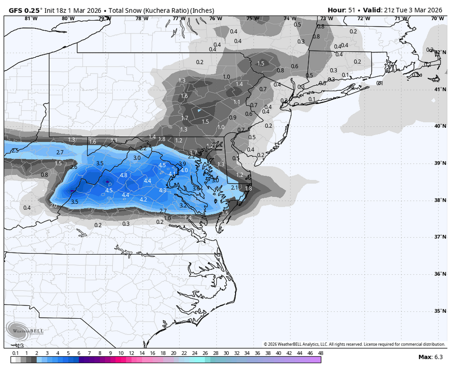
-
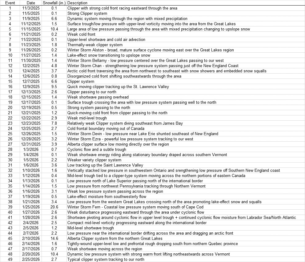
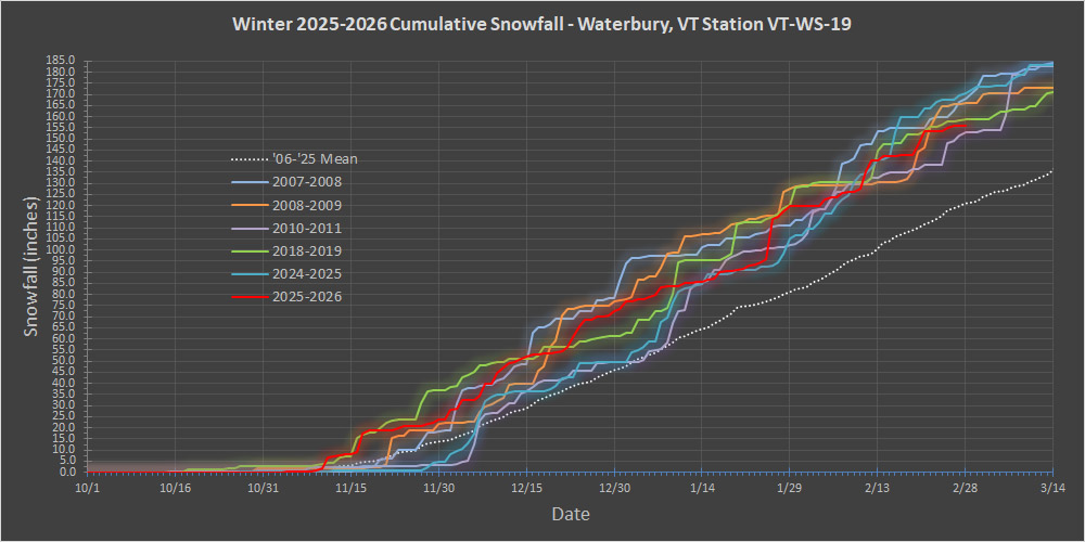
We’ve finished up February now, so it’s a good time for an update on seasonal snowfall progress here at our site in Waterbury. February snowfall was 36.0”, so below the average of up around 40”, but it was within 1 S.D. and not too far off of an average month. More notable was that February was the first below average snowfall month we’ve had all season – November, December, and January were all above. Technically, October was also below average on snowfall, but it’s quite variable to begin with, and a below average performance is not uncommon. Also notable was that February was lean on storms – there were only 8 snowstorms for the month. That’s tied for the lowest number of February storms I’ve recorded here, and those other seasons in which it happened were 2008-2009 and 2011-2012. November, December, and January all had between 11 and 16 storms as detailed in the winter storm table below, so it’s clear that the pace of storms has fall off as of late. We haven’t really been in any of those Northern Greens bread and butter patterns recently, which can obviously knock down the pace of storms and snowfall relative to the earlier months when the storms were just queued up and running into the spine. The updated seasonal snowfall progression plot is below, and a couple of new comparative seasons (2010-2011 and 2024-2025) have made the plot now that we’re this far into the winter. Those seasons hadn’t made it onto the plot before because they were late bloomers, but once they turned it on they were formidable. As you can see, by this point, both of those newly added seasons were right up there at the top of the pack, setting the pace among some very solid winters. This season (shown in the red line) has recently fallen off the pace a bit, but it’s still right in there among the group. We’ll have to see what the next 2 to 3 months of winter bring, but the projections for the likelihood of this season hitting certain snowfall thresholds are show below: ≥150”: 100.0% ≥160”: 96.6% ≥170”: 89.3% ≥180”: 74.5% ≥190”: 46.9% ≥200”: 30.7% Obviously hitting 150” is a lock now, but the odds are also quite strong for surpassing that 160” threshold to reach a roughly average season. Hitting 200” is certainly still possible based on the numbers, and we really only need ~40” or so of snow to do it, but it will depend on how March and April go. These later months of winter have far more snowfall variability and are a lot more “Jekyll & Hyde” in character. We’ve had numerous March-April combos deliver 60-70” inches in strong late seasons, but some late winter periods can act very benign and spring-like. We’ll just have to see how March progresses, but aside from a system in the coming midweek period, there’s not much modeled for the next several days. Looking back, we’d already reached 120” of snowfall by the midpoint of this season, so it was intriguing to check on what the odds were of matching that first half total in the second half of the season, but the odds of hitting 240” have dropped below 1% at this point. So, I didn’t add those higher numbers to the list of odds calculations above. Obviously the odds of stacking together two 120” halves of the season are quite tough, and at this point it would take a record March-April-May stretch to do it. Sometimes we can get those monster March events though, so we’ll see where things stand if something like that happens. On a final note, I did a quick check on where the Vermont ski areas stand for season snowfall thus far, and the north to south listing of totals is below. The pace of snowfall has obviously fallen off here in the mountains as well, but similar to our site in the valley, the resorts along the spine of the Northern Greens are already closing in on their seasonal snowfall averages with a couple of months still to go. Aside from Jay Peak, which now looks to be mirroring our pace here in the valley with respect to average snowfall pace, the other areas at elevation in the Northern Greens are a bit more off that pace with about 30-40” to go to hit that 300” mark. Jay Peak: 353” Burke: 148” Smuggler’s Notch: 264” Stowe: 254” Bolton Valley: 261” Mad River Glen: 171” Sugarbush: 199” Saskadena Six: 71” Pico: 174” Killington: 174” Okemo: 112” Bromley: 160” Magic Mountain: 98” Stratton: 142” Mount Snow: 117”

-
If I could push it your way I would.
-
Winter is probably gonna make a late March comeback. Probably too late for us, but good for areas north of Central PA. Eps looks very similar.
-
Central PA Winter 25/26 Discussion and Obs
Blizzard of 93 replied to MAG5035's topic in Upstate New York/Pennsylvania
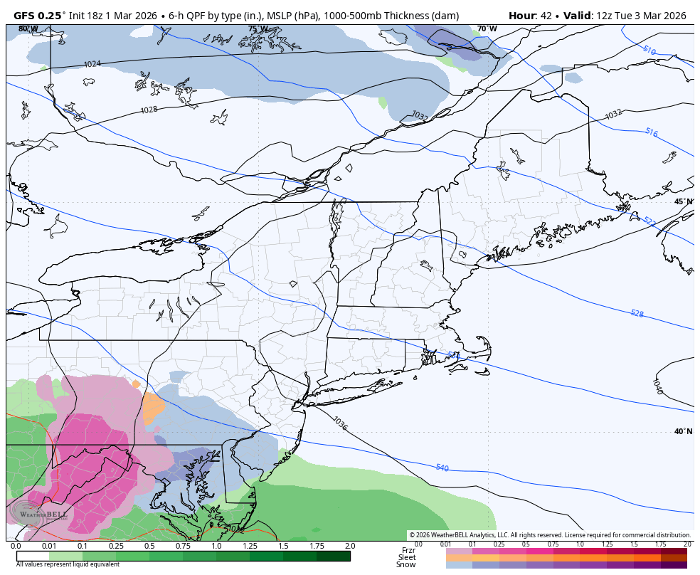
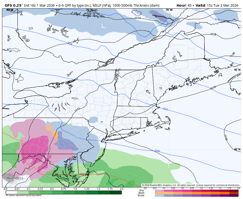
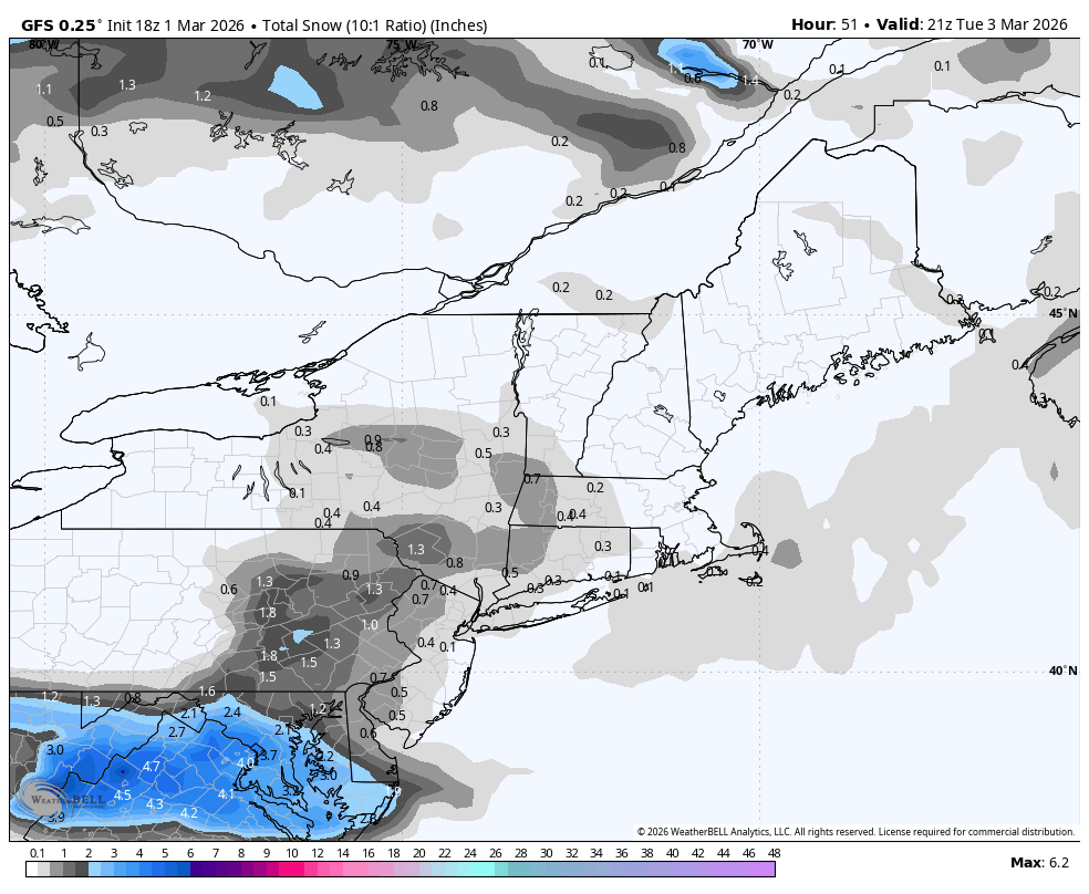
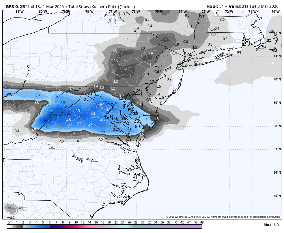
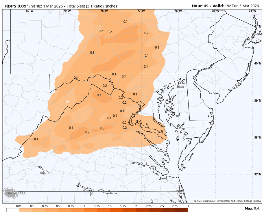
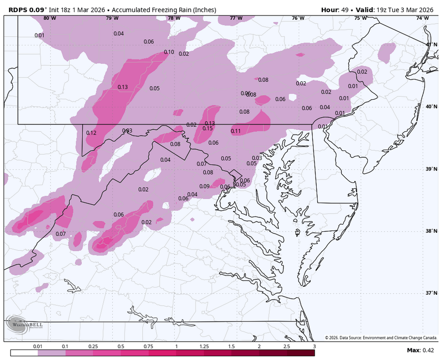
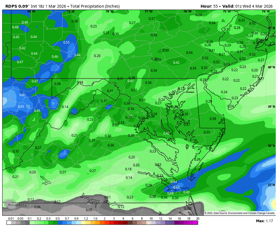
CTP is forecasting the kitchen sink for the Harrisburg area tomorrow night into Tuesday am: Monday Night A chance of freezing rain and sleet after 1am. Increasing clouds, with a low around 27. Southeast wind 7 to 10 mph. Chance of precipitation is 50%. New sleet accumulation of less than a half inch possible. Tuesday Snow showers and freezing rain, possibly mixed with sleet before 10am, then rain or freezing rain between 10am and 1pm, then rain showers after 1pm. High near 40. Southeast wind 6 to 9 mph. Chance of precipitation is 90%. New snow and sleet accumulation of less than a half inch possible.