All Activity
- Past hour
-
12Z Euro/GFS coldest low at Chicago 1/6-1/18: 22/30 12Z EPS/GEFS coldest low at Chicago 1/6-18: 22/25 Normal low 20-18 Not good for SE cold prospects. So, hopefully they’re going to turn out way too warm like 12/28-1/1 and earlier periods did. We’ll see. If not, it’s going to be very hard for the SE overall to get substantially cold before 1/20.
-

E PA/NJ/DE Winter 2025-26 Obs/Discussion
Ralph Wiggum replied to LVblizzard's topic in Philadelphia Region
Just a January thaw. We've been in a freeze since right after Thanksgiving. Its going to be ok...winter will return. Just look ahead at 5 days max dont get caught up in 2 weeks out. Enjoy the reload period. -
FWIW even BAM isn’t 100 percent on board with the red flags he found.
-
Venture to this thread at your own risk. I am still positive towards mid month and the second half of Jan.
-
The boom for this was like a half inch lol
-
I was not confident enough to state it but I was thinking something similar. The blocking is there, and we’ve been complaining about a pacific look that left us fighting for NS scraps for the last month. That look gives us a chance at some actual southern energy I would guess. Temps would be the main issue but on an ensemble run that’s too far out to worry about temps. The right shortwave progression with a look like this could deliver the cold no problem.
-

January 2026 regional war/obs/disco thread
Torch Tiger replied to Baroclinic Zone's topic in New England
new year -
How about negative epo ?
-
We also used to get big synoptic snows in those months and we don't anymore. We have gotten more snow than TN border areas many times out of Gulf lows. We did in January 2022 and in December 2018.
-
I don’t have a ton of time, but good trends at 12 across modeling. The 12z GEPS has a much stronger eastern trough before dumping it west in the last few frames of fantasy land. If we take the idea that modeling trends west with storms….not a bad place to be right now.
-
This was never a super serious thread lol. Ji needs a Xanax.
-
He mentioned GEFS and you posted GEPS
-

E PA/NJ/DE Winter 2025-26 Obs/Discussion
JenkinsJinkies replied to LVblizzard's topic in Philadelphia Region
It's just a bunch of snow weenies losing their minds over a 4 day warmup, nothing unusual about that. In a clipper/Miller B pattern yes but if it's a full blown shit the blinds pattern for the MA then Philly proper and the immediate areas are usually SOL as well. -
1. I never said it would verify cold, I said it was a time period to watch (which it still could be). I was never sold on the first 10 days of January thats going to be a torch 2. You generally bet on cold and snowy regardless of what the models say and thats ok.
-

January 2026 regional war/obs/disco thread
Ginx snewx replied to Baroclinic Zone's topic in New England
Skynet
-
C'mon guys, anything more than a half inch out of this was a long shot. Also, if the 0.2 verifies then DCA will also be safe from adding to the futility list this year.
-
The 12Z Euro Op ends the January Thaw on the 11th - and a few days later there is a coastal low coming up the coast that originated in the Gulf -ALSO NOTICE THAT STRONG HP STAYS ANCHORED OVER THE ROCKIES - SOLID POS PNA PATTERN
-
This is a pretty flat ass ridge- Look at the trough in the SW.. follow the height lines and ignore the colors.. Verbatim we get snow (as far south as S VA) during this period.
-

January 2026 regional war/obs/disco thread
Damage In Tolland replied to Baroclinic Zone's topic in New England
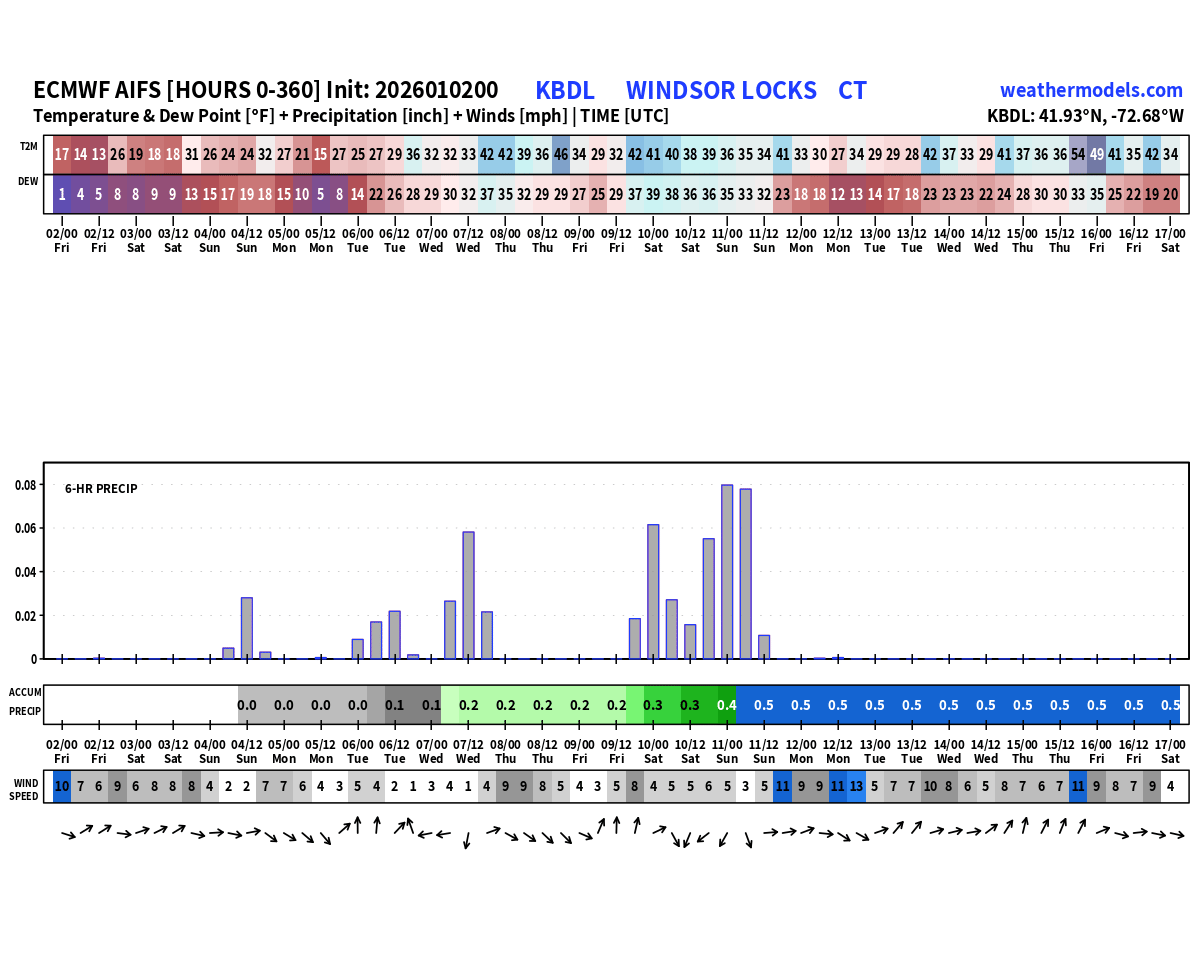
Sundays northern stream system digging. May be enough for a fluffy inch or two -
He did
-
i would not bet against more snow this winter, meaningful snow at that....
-
he is also showing the worlds poorest performing ensemble
-
Yes I'm sure the admins do
-
since when do we use Euro ens for an event that starts in 24 hours?
-
I got the GFS and the Euro ens giving me snow. This is serious stuff here.