All Activity
- Past hour
-

-
-

July 2025 Obs/Disco ... possible historic month for heat
powderfreak replied to Typhoon Tip's topic in New England
1.30" now, that 0.50" was short lived. It just keeps reforming. It's like dry a mile SE of here in RT 100/108 intersection. Rainfall rate peaked at over 2"/hr but is back down around 1"/hr. -
right or wrong, you troll him....and others, and its always a 1 -2 punch w/ you and your TC warmie pal. You guys sit in same chair?? asking for friends. No matter....its old, and poor form.
-
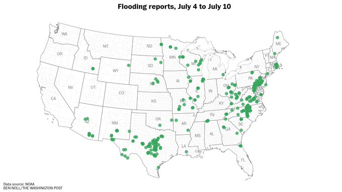
Looks like maybe we'll get some drought mitigation the next day or two after all?
-
just did mine 2 years ago, and we went w/ corrugated tin.... Yeah that check hurt to write. Hoping the extra jingles paid will be justified in long run. We do like the look.
-

July 2025 Obs/Disco ... possible historic month for heat
klw replied to Typhoon Tip's topic in New England
We are at 1.55 here in central downtown Hyde Park. It will pour for 5 minutes, stop, restart., stop... https://www.wunderground.com/dashboard/pws/KVTHYDEP1 -
July 2025 Obs/Disco ... possible historic month for heat
klw replied to Typhoon Tip's topic in New England
flood warning issued up in northern VT https://forecast.weather.gov/wwamap/wwatxtget.php?cwa=BTV&wwa=flood warning -
July 2025 Obs/Disco ... possible historic month for heat
powderfreak replied to Typhoon Tip's topic in New England
That entire image is like 2 miles across, 3 miles tops corner to corner. Just getting crushed with localized rain now again. My house is the dot. Mountain is sunny 5 miles away. Gotta make up our deficit from Weymouth this morning.
-

July 2025 Obs/Disco ... possible historic month for heat
HoarfrostHubb replied to Typhoon Tip's topic in New England
Interesting… -

2025-2026 ENSO
Stormchaserchuck1 replied to 40/70 Benchmark's topic in Weather Forecasting and Discussion
Anyway.. check out this +AO. Getting light purple on this map, almost hitting the Polar Vortex, in mid-July is pretty rare. It's 5200dm over northern Canada. -
July 2025 Obs/Disco ... possible historic month for heat
powderfreak replied to Typhoon Tip's topic in New England
It’s always fascinating how localized convective rain is. I live on the south side of the Stowe Country Club (say near the "C" in club)… around a half inch so far today but increasing. North side of the golf course is over 1”. A mile SW in center of Stowe Village is only 0.08” (that’s the Cocorahs station spot). A half inch difference across the golf course is wild though.
-

July 2025 Obs/Disco ... possible historic month for heat
Torch Tiger replied to Typhoon Tip's topic in New England
good -
2025-2026 ENSO
Stormchaserchuck1 replied to 40/70 Benchmark's topic in Weather Forecasting and Discussion
All seasonal models seem to have a strong -PNA despite Neutral ENSO.. for the 2nd year in a row. Last year they were pretty far off though (for DJF). -
Yeah, needing a classic summer few days of nighttime MCS's; but those seems to be a things of the past.
-
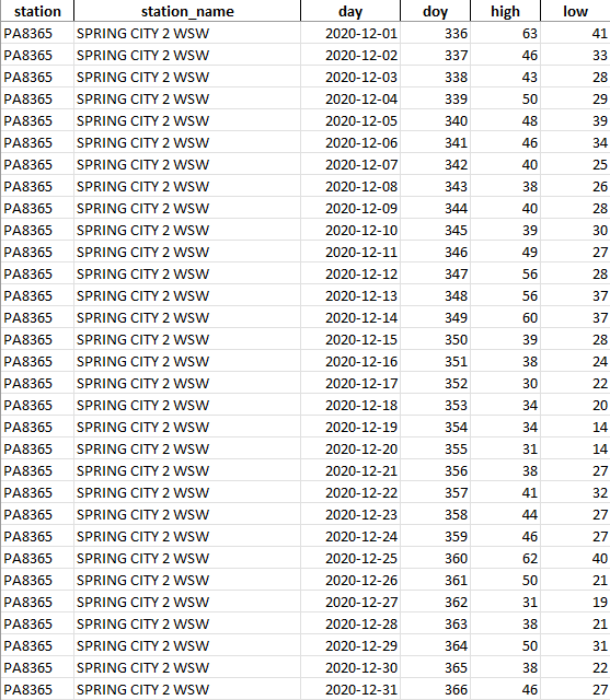
 Looks like some more recent ghost station activity being captured....this time at the newest COOP Location in Chester County PA. Station SPRING CITY 2 WSW, PA which began it's first ghastly estimated data on January 1, 2020.....yet the first actual true temperature record was not made for almost 3 and 1/2 years later or 40 months later in late May of 2023! Below is the NOAA COOP report from December 2020 and then the ghost data now incorporated for estimations.
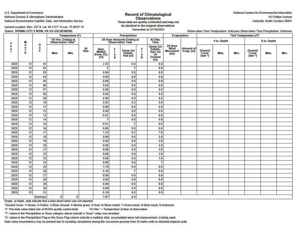
-
I signed a contract for a new roof so it can stop raining for 3 o4 so weeks so it can get put on kthnx Also anyone want to gift me cash? Ha!
-
Implies SE ridge dominance?
-
2025-2026 ENSO
Stormchaserchuck1 replied to 40/70 Benchmark's topic in Weather Forecasting and Discussion
July Euro seasonal forecast for NDJ (that's as far out as I saw it go) - Today
-

July 2025 Discussion-OBS - seasonable summer variability
rclab replied to wdrag's topic in New York City Metro
Liberty you’re amazing. You can post and landscape at the same time. Stay well, as always ….. -
The exception was S and E of the I-95 corridor; the storms just couldn't make much progress past there. I got brushed with 0.17". Hoping for more today (although hoping the places which have been inundated stay dry)
-
Climate Alarmists really are a tolerant bunch....fortunately we are starting to get more and more young meteorology professionals like Chris! Sadly, there are many older and younger professionals that Chris and I speak with in private....who share our concern about the damage being done by climate alarmists and zealots. Yet they feel forced to remain silent with their dissenting views that there is in fact no climate emergency at all. Fortunately the tide is turning and folks are coming back to common sense and calm around our always changing climate! https://freebeacon.com/policy/im-a-young-meteorologist-who-questioned-the-idea-of-man-made-climate-change-the-climate-zealots-wanted-me-punished-silenced-and-expelled/
-

July 2025 Obs/Disco ... possible historic month for heat
CoastalWx replied to Typhoon Tip's topic in New England
I'll burn everything from I-91 east if that happens. -
July 2025 Obs/Disco ... possible historic month for heat
rclab replied to Typhoon Tip's topic in New England
….. and harder too ….. as always …..
-

July 2025 Obs/Disco ... possible historic month for heat
Damage In Tolland replied to Typhoon Tip's topic in New England
He”ll be back this winter there