All Activity
- Past hour
-

2026-2027 Record-breaking El Nino
GaWx replied to Stormchaserchuck1's topic in Weather Forecasting and Discussion
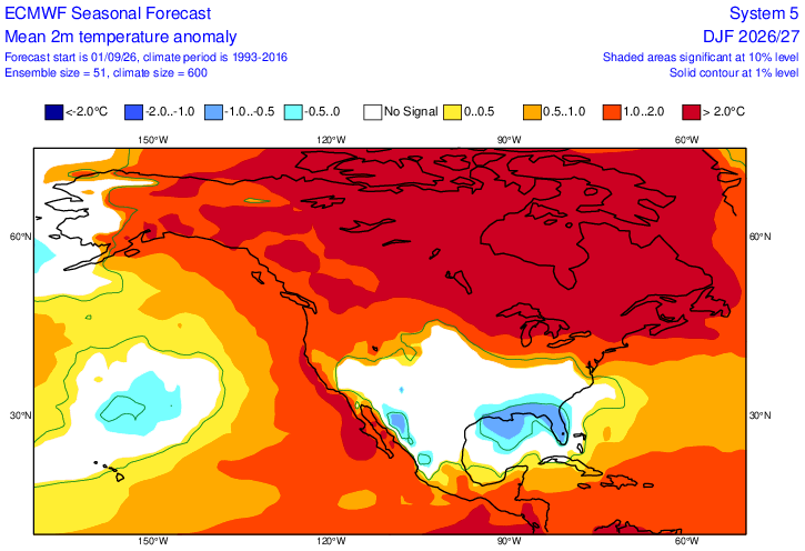
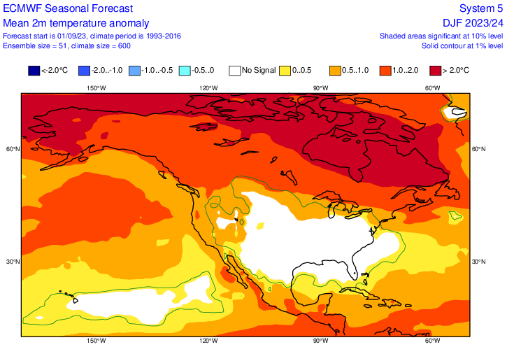
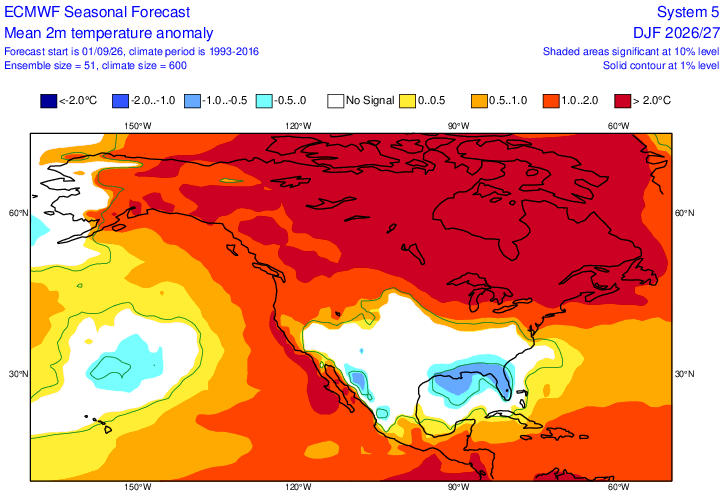
Comparison of Sept ‘23 Euro for DJF 23-4 and Sept ‘26 for DJF 26-7: ~twice the contrast N to S ‘26-7 vs ‘23-4 in E US ’23: ‘26: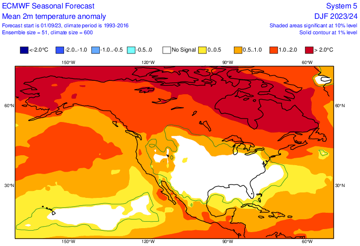
-
If I knew we were actually going to only be +1C for DJF, I'd be pretty bullish for snow. Perhaps even more so if you can wag that December makes up most of that + anomaly and JF are near normal or even a touch below. But that's all weenie-casting right now.
-
.25" rain from 10:30 - 11:40 The Graf model from 5 am was exactly right with 100% rainfall while NWS was only 30%. At less than 12 hrs. it seems that Graf is more accurate than NWS.
-
September 5 1990: Nine inches of rain falls in Duluth by the end of the following day, washing out $1,000,000 worth of roads. 1982: 77 mph winds are reported in Anoka County. For Saturday, September 5, 2026 1925 - The temperature at Centerville, AL, soars to 112 degrees to establish a state record. Every reporting station in Alabama was 100 degrees or above that afternoon. (The Weather Channel) 1933 - A hurricane hit Brownsville, TX, killing forty persons and causing 12 million dollars damage. (David Ludlum) 1950 - Hurricane Easy produced the greatest 24 hour rainfall in U.S. weather records. The hurricane deluged Yankeetown, on the upper west coast of Florida, with 38.7 inches of rain. (David Ludlum) 1975 - Strong winds reduced visibilities to near zero in blowing dust resulting in a 22-car chain reaction accident on Interstate 10 near Toltec AZ. Two persons were killed, and 14 others were injured. (The Weather Channel) 1987 - Thunderstorms over the Southern and Middle Atlantic Coast States drenched Charleston, SC, with 5.50 inches of rain, and a total of 13.50 inches in two days, flooding homes, and leaving roads and bridges under water. (The National Weather Summary) A tropical storm which formed off the South Atlantic coast was responsible for torrential rains over coastal regions of South Carolina. Between the 30th of August and the 8th of September, Charleston SC received 18.44 inches of rain. The heavy rains caused extensive flooding around the city of Charleston, seriously damaged cotton crops in the eastern part of the state, and resulted in an unusually high number of mosquitos. (Storm Data) 1988 - Five days of heavy rain commenced in west central Florida. Up to 20 inches of rain in four days resulted in extensive urban flooding, and evacuation of 1000 homes. Flooding claimed four lives, and caused more than five million dollars proprty damage. (The National Weather Summary)(Storm Data) 1989 - Thunderstorms produced six to ten inches of rain in south central Kansas between 6 AM and Noon. Serious flooding was reported around Wichita, with water four feet deep along some roads. A cold front crossing the Northern High Plains Region produced wind gusts to 63 mph at Sheridan WY. (Storm Data) (The National Weather Summary) Observances: 5 Sat World Beard Day 5 Sat National Cheese Pizza Day 5 Sat World Samosa Day 5 Sat National Be Late For Something Day 5 Sat National Act Dumb Day 5 Sat National Cellulite Day 5 Sat National Shrink Day 5 Sat International Day of Charity
-
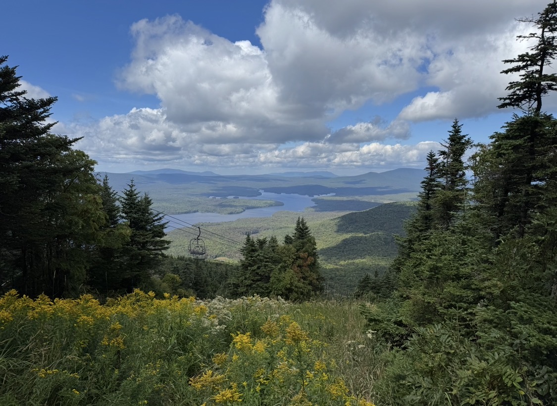
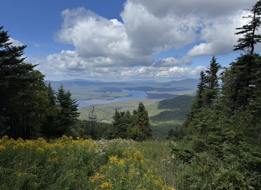
From the top of Mount Snow yesterday
-

Central PA Summer 2026 Discussion/Obs Thread
canderson replied to Voyager's topic in Upstate New York/Pennsylvania
Headed to Baltimore this afternoon to see the Sox; very appreciative of the lowering dews and low-to-mid 80s highs! -
Comparison of Sept ‘23 Euro for DJF 23-4 and Sept ‘26 for DJF 26-7: ’23: ‘26:
-

Winter 2026-2027 Seasonal Outlook
WinstonSalemArlington replied to WinstonSalemArlington's topic in Southeastern States
-

Septorcher 2026 Discussion - Endless Summer
Great Snow 1717 replied to Damage In Tolland's topic in New England
For this site getting you is like Red selecting Bird with the 6th pick in the 1978 draft!! You future enshrinment into the AMWX Hall of Fame is a lock!! -
yea i remember that---we were laughing at how we needed the pattern to go nina for us to score snow during that Nino. That season, canada was so blowtorched that we could never recover. but the models looked really good in the fall looking ahead to that winter. Thats the scary part
-
86 this morning. Low of 76
-
Trend this month is warmer....hope it's wrong.
-
Interesting + PNA phase might happen
-
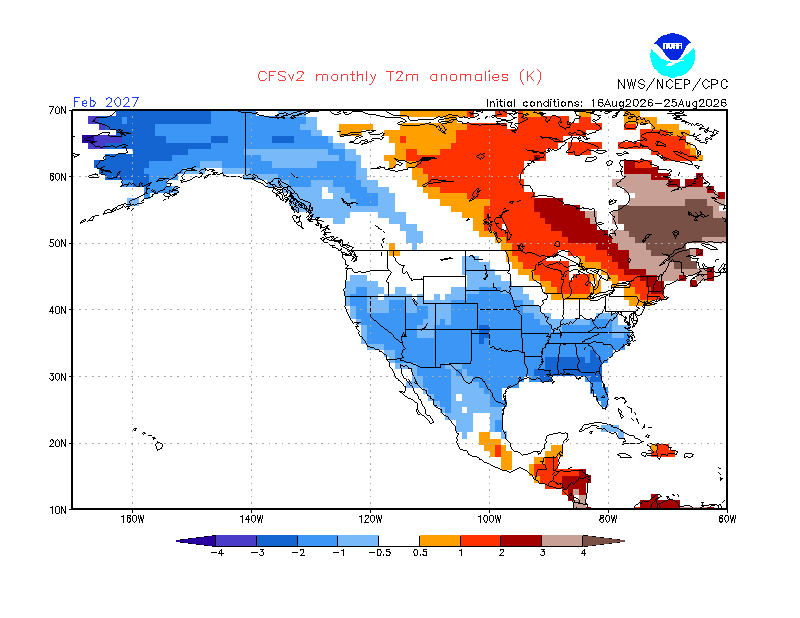
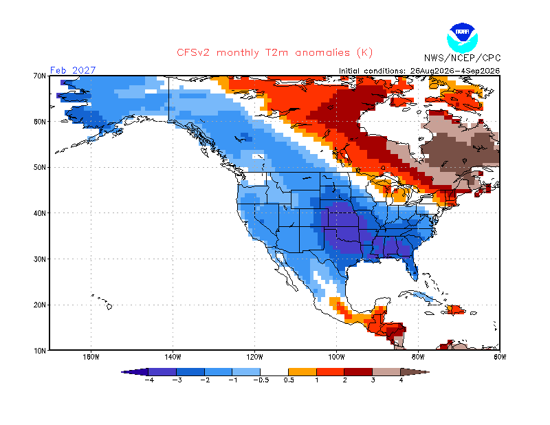
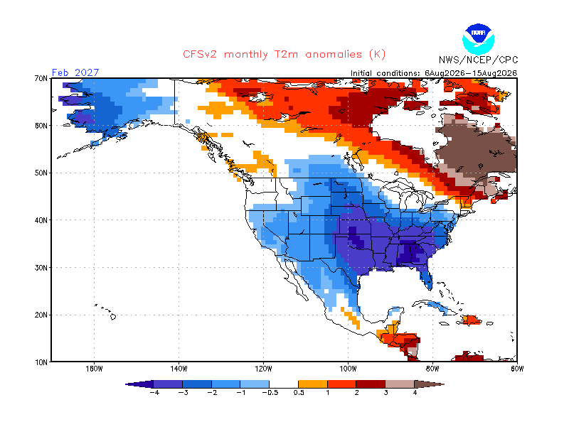
Will, thanks for posting. Unfortunately, WB CFS temp. maps have major algo flaws and thus I rarely post them. Example: they usually have a major cold spot over S Lake Michigan and a major warm spot over N L. Mich & vicinity just 250 miles to the N! Also, they tend to have too much contrast between well inland areas of the E 1/2 of the US (too cold) and the much warmer near E coast (often too warm). Related to this, WB shows at/near record cold Feb/Mar of -5 to -7C (and even vs the colder 1981-2010 climo!) in those areas with the 3rd-6th shades of green based on the means of 30 days of runs. The CFSv2 site shows nothing of the sort: examples for Feb: 1) Columbus, GA, in Feb is ~-3.5C vs 1991-2020 for the avg of the 3 maps below from the CFSv2 site, itself, whereas WB has them ~-5C vs the colder 1981-2010 or ~2C/3.6F too cold (1991-2020 is 0.5C warmer than 1981-2010). 2) At the same time, the NC/VA border on E coast in Feb is ~-1.5C vs 1991-2020 on CFSv2 compared to NN on WB vs the colder 1981-2010 meaning WB is ~1C too warm 8/6-15: 8/16-25: 8/26-9/4:
-
We are entering a dry period during the next 7 days, unless the Thursday system delivers which is unlikely at this time. At least we are losing solar heating and the days are getting shorter.
-
Hideous look with Aleutian low over AK and massive + EPO. Open the torch Pacific floodgates if this happens
-
The cruel irony of 23-24 is that when it snowed, it was from northern stream systems squeezed under the canadian block at a time when the STJ took a break. When the STJ was active, it was rain every time. Cape Breton did get buried under 5 feet of snow in one storm thanks to the STJ, so at least there’s that.
-
 buy misoprostol over the counter: cytotec abortion pill : cytotec abortion pill
 -
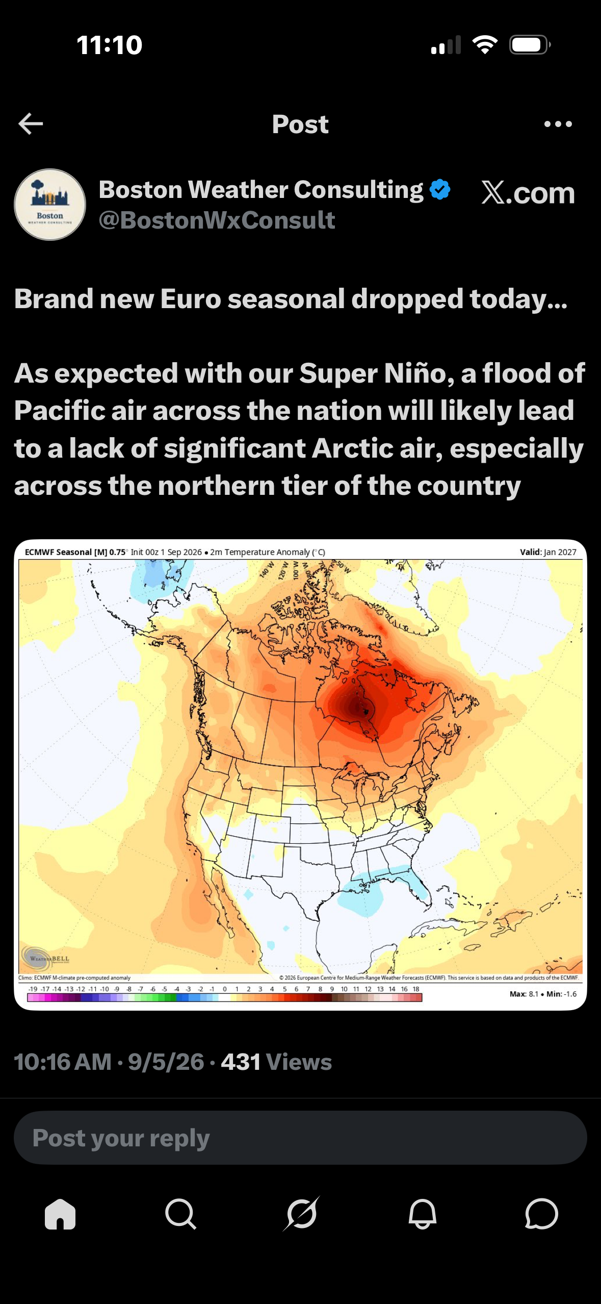
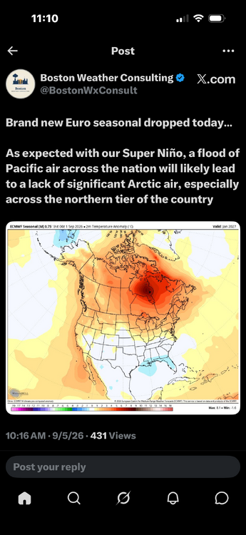
this dosent look that much different from the euro seasonal for 23-24 and that was a disaster but on paper it looked good. I see a lot of people on twitter in England are super excited because they say this shows a very strong -NAO signtature but i would like that red further north
-

Central PA Summer 2026 Discussion/Obs Thread
Blizzard of 93 replied to Voyager's topic in Upstate New York/Pennsylvania
Refreshing dew points are here! -
This was the light show in the clouds before I got that shot: https://www.facebook.com/reel/1085227447341802
-
http://hairguardrx.shop/# cost of cheap propecia online
-

2026-2027 Record-breaking El Nino
MJO812 replied to Stormchaserchuck1's topic in Weather Forecasting and Discussion
Yep nice stj train. How do you know it shows 10 inches ? People need to stop making statements. 1 storm can do wonders. - Today
-

Septorcher 2026 Discussion - Endless Summer
WxWatcher007 replied to Damage In Tolland's topic in New England
My God, the GFS. -
http://hairguardrx.shop/# cost of cheap propecia online