All Activity
- Past hour
-
Mine is doing the same. It’s going crazy with blooms so late.
-
Too early to say anything about the winter pattern
-
It appears NHC overshot the actual winds and pressure drop with the 5 am advisory. But I understand operationally why they would not want to drop the winds, which could imply a weakening system. They obviously do not want anyone to start letting their guard down with the main rain shield now very close to reaching Jamaica.
-

2025 Atlantic Hurricane Season
NorthHillsWx replied to BarryStantonGBP's topic in Tropical Headquarters
If forecasts hold, Melissa all but guarantees we will finish the season above average ACE. This legitimately did not seem possible going into the third week of September -
I think the NHC got a bit ahead of themselves here.
-
Crazy that 4 of 5 hurricanes this year have been cat 4+
-
Records: Highs: EWR: 82 (2023) NYC: 78 (1964) LGA: 80 (2023) JFK: 78 (1971) Lows: EWR: 31 (1952) NYC: 30 (1879) LGA: 34 (1962) JFK: 32 (1962) Historical: 1859 - New York City had their earliest substantial snow of record as four inches blanketed the city. (David Ludlum) 1865: A hurricane sank the steamship USS Mobile off the Georgia coast. The wreck, laden with 20,000 gold coins, was found in 2003. 1879: Boston, Massachusetts had a low temperature of 25 °F on October 26th the coldest temperature for October. Also another 25 °F low was recorded on October 27, 1936. (Ref. NOAA Boston Weather Events) 1919 - The temperature at Bismarck, ND, plunged to ten degrees below zero, the earliest subzero reading of record for the city, and a record for the month of October. (The Weather Channel) 1926 - Barrow, AK, received a record fifteen inches of snow, and also established a 24 hour precipitation record of 1.00 inch which lasted until the 21st of July in 1987. (The Weather Channel) 1952: There have been thousands of weather reconnaissance and research flights into hurricanes in the Atlantic and Pacific since the mid-1940s. There have been several close calls, but only four flights have been lost. A B-29 Super-fortress flight into Super Typhoon Wilma 350 miles east of Leyte in the Philippines disappeared on this date. No trace was ever found of the plane or crew. In the last report, the flight was in the Super typhoon's strongest winds, which were around 160 mph. 1962 - A storm brought five to six inches of snow to Vermont and New Hampshire, with up to ten inches reported in the mountains. (The Weather Channel) 1962: An early season snowstorm hit New England with the most snow over interior sections. Greenville, ME recorded 13.9 inches Worcester, MA recorded 4.7 inches and Portland, ME had 3.6 inches. All of these amounts were new records for the greatest amount of snow for so early in the season. (Ref. AccWeather Weather History) Canadian high pressure ushered record cold from the northern Plains to the Southeast. Rockford, IL at 18° recorded their coldest October temperature. Other daily record lows included: Beckley, WV: 18°, Cincinnati, OH: 19°, Dayton, OH: 21°, Mansfield, OH: 21°, Huntington, WV: 21°, Springfield, IL: 22°, Columbus, OH: 23°, Lexington, KY: 23°, Akron, OH: 24°, Charleston, WV: 24°, Lynchburg, VA: 25°, Pittsburgh, PA: 25°, Raleigh, NC: 27°, Charlotte, NC: 29°, Atlanta, GA: 30°, Athens, GA: 31°, Montgomery, AL: 32°, Wilmington, NC: 32°, Charleston, SC: 33°, Savannah, GA: 34° and Norfolk, VA: 36°. (Ref. Wilson Wx. History) 1968: Canadian high pressure system behind a strong cold front brought chilly temperatures to the Southeast. Cross City, FL reported and all-time October record low of 30°. Other daily record lows included: Nashville, TN: 27°, Paducah, KY: 28°, Chattanooga, TN: 29°, Birmingham, AL: 29°, Atlanta, GA: 29°, Montgomery, AL: 31°, Macon, GA: 32°, Tallahassee, FL: 35°, Baton Rouge, LA: 37°-Tied, Pensacola, FL: 40°-Tied and Vero Beach, FL: 50°. (Ref. Wilson Wx. History) 1983 - A heat wave was in progress over the Northern Rockies, with record highs of 81 degrees at Sheridan WY and Billings MT.(Sandra and TI Richard Sanders - 1987) 1987 - Five cities in south central Texas reported record high temperatures for the date, including Corpus Christi and Del Rio with readings of 93 degrees. Laredo TX was the hot spot in the nation with a high of 98 degrees. Thunderstorms moving over the Lower Mississsippi Valley deluged Lake Charles LA with 2.70 inches of rain in one hour resulting in severe local flooding. (The National Weather Summary) (Storm Data) 1997: An autumn snowstorm pummeled central and south-central Nebraska with record early season snows. Wind-driven snowfall amounts totaled as much as two feet by storms' end. Several highways were closed, including Interstate 80, as near-blizzard conditions developed. Once the snow subsided, the record early season snow totals were tallied. Guide Rock measured twenty-four inches of snow, Clay Center twenty-three inches, and Hastings seventeen inches. A fifty-mile wide swath of snow more than fifteen inches fell from near Alma to York. Amounts further north averaged from four to eight inches. The heavy, wet snow was responsible for many power outages in the area as tree limbs broke and fell on power lines. At one point, the town of Hardy had no power and could not be accessed by vehicles due to the snow. Numerous schools and businesses remained closed several days following the storm. Many highways, including Interstate 80, closed at the height of the storm. On Highway 136 east of Alma, road crews worked for ten hours carving through a ten-foot drift that covered the road. Record cold accompanied the snow as temperatures dropped to the single digits on the morning of the 26th. 1988 - Thunderstorms moving out of northern Texas spawned five tornadoes in Louisiana during the morning hours. The thunderstorms also produced wind gusts to 75 mph at Jennings LA, and the driver of a vehicle was killed by a falling tree near Coushatta LA. Snow squalls in the Lower Great Lakes Region produced heavy snow in western New York State, with 12 inches reported at Colden. (The National Weather Summary) (Storm Data) 1989 - Unseasonably warm weather continued in the north central U.S. Afternoon highs of 78 degrees at Alpena MI, 75 degrees at Duluth MN, 79 degrees at Fargo ND, 77 degrees at International Falls MN, 76 degrees at Marquette MI, 75 degrees at Sault Ste Marie MI, and 80 degrees at Saint Cloud MN, were all the warmest of record for so late in the season. Morning lows of 63 degrees at Concordia KS and Omaha NE were the warmest of record for the date. (The National Weather Summary) 1997: Scientists discovered a massive "blowdown" of 20,000 acres of spruce trees in north-central Colorado. 31 square miles of old-growth forests high in the Rockies were destroyed by unusual "mountain wave" clouds that blew 120 mph winds along the western side of the Continental Divide as a major blizzard pounded the Plains from the through the 26th. Behind the storm, record low temperatures were reported across the Plains including: Scottsbluff, NE: 0°, Rapid City, SD: 2°, Goodland, KS: 10°, Grand Island, NE: 13°-Tied and Omaha, NE: 21°-Tied. (Ref. Wilson Wx. History) 1998: Hurricane Mitch, the second deadliest hurricane in the Atlantic Ocean, reached Category 5 strength on this day. 2002: The football game between the Richmond Spiders and Rhode Island was suspended due to a flooded field at Meade Stadium in Kingston, RI. The field began to become covered with water during the first half, but a halftime downpour covered the entire field. Water was knee deep on parts of the field and no grass was visible by the time the game was suspended. (Ref. Wilson Wx. History) 2005: The summit on Mt. Washington, NH received an additional 27.5 inches of snow during the overnight to break their 24-hour snowfall record set just 9 days earlier. During the previous 12 days, 72 inches fell, nearly 25 % of the normal yearly total. (Ref. Wilson Wx. History) (Ref. WxDoctor)
-
The sun is just starting to peek through here, low of only 43 due to all the clouds, 45 currently.
-

Central PA Fall Discussions and Obs
mahantango#1 replied to ChescoWx's topic in Upstate New York/Pennsylvania
30 this morning with fog that rolled in. -
The reality is what is is on the Pacific side, and since that is the largest ocean and holder of worldwide heat, it largely drives our weather. We can deal with modestly unfavorable and make it work with a decent NAO and luck like 2010-11 for example, but off the charts unfavorable like the last few years and there's just no way for it to work unless we pull something like a royal flush. I don't like the reality same as anyone else here but we have to accept it. The N PAC especially east of Japan needs to markedly change for there to be good favorable windows near the coast for snowstorms. Maybe some combination of factors can happen to pull a rabbit out of the hat but we saw last winter-time after time favorable setups collapsed. If this was 15-20 years ago when the Pacific was better, last winter would've been a 50"+ season areawide.
-
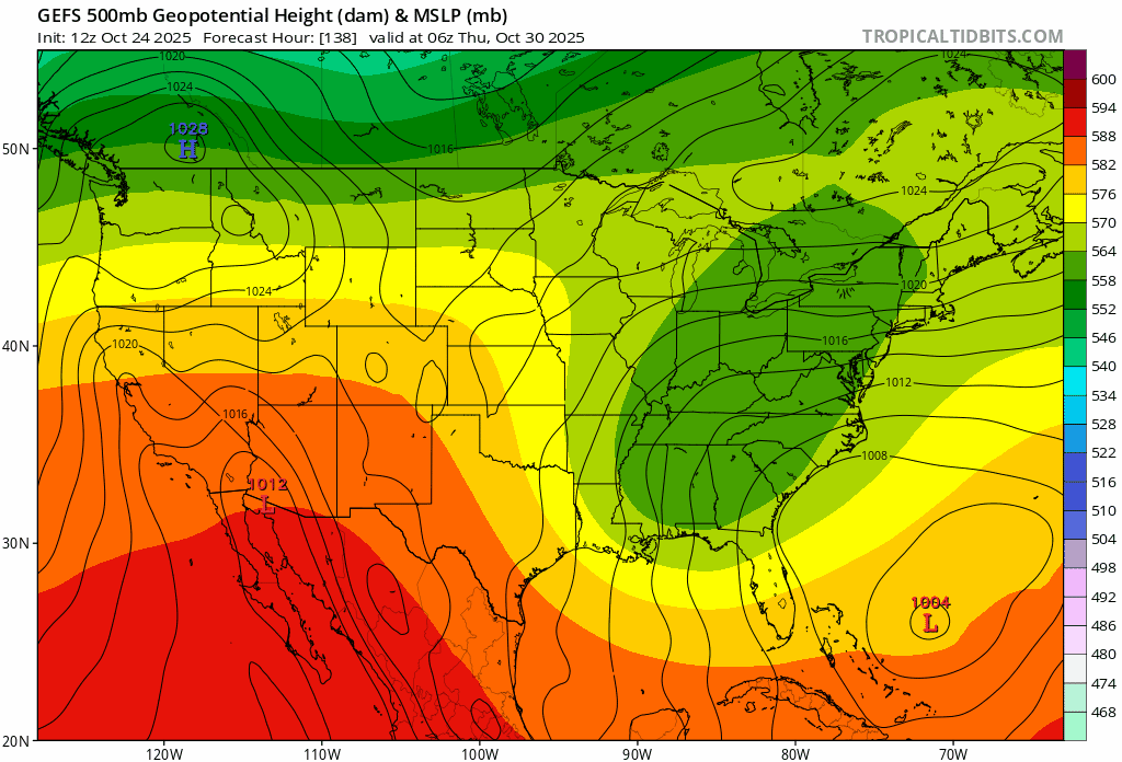
45 / 44 partly cloudy. Should clear up to get mostly sunny with warmest at or low 60s. Dry / cooler Mon - Wed before dealing withthe cutoff and system Thu (30th) it does look to dry up and perhaps clear out for fri. Beyond there near - below normal the opening week with progression toward or above normal overall beyond there.
-
Second pass: slightly higher winds in the NE eyewall but no change in pressure and no support of 140 mph winds.
-
What I have been saying is that the faster Northern Stream of the Pacific Jet driven by the gradient formed between the record SSTs over the WPAC and Siberian cold has lead to the dominant cutter, hugger, and suppressed Southern Stream since 2018-2019 producing the record low 7 year snowfall totals along the I -95 corridor. My early guess for this winter is that average DJF temperatures will be warmer than last winter was based on the tropical forcing that we are currently experiencing. I was able to identify the factor last October which lead to the colder winter which I discussed in the main forum. This feature isn’t there this October. But since the snowfall was so low last winter, can’t be sure whether we see something similar again or we get a short term favorable MJO leading to higher snowfall totals than last winter. Since we could beat last winters snowfall totals with a few good storm tracks. But the December 4” rule will probably be in effect again for La Ninas. Nearly all La Niña winters since 1991 with under 4” at places like NYC and Newark in December finished the season below. And all above this level went into snowy seasons. Last December we came in under which lead to my December guess for another below average snowfall season which worked out.
-
RSTM2 COOP site - had my first sub 60 degree high f the autumn yesterday. Got down to 36 last night, yet somehow our hibiscus on the deck is still pumping out blooms.
-

Spooky Season (October Disco Thread)
Baroclinic Zone replied to Prismshine Productions's topic in New England
Will be an interesting real time human experiment. -
Yeah I agree with that. Weakening or structural changes, another way this could be less than worst-case.
-
Spooky Season (October Disco Thread)
Baroclinic Zone replied to Prismshine Productions's topic in New England
GWDHTGOCA -
so you are saying we will have an inland runner pattern this winter similar to this late week storm and snowfall will be limited in the metro this winter ?
-
Each event is constrained by the overall pattern and not the other way around.
-

Spooky Season (October Disco Thread)
dendrite replied to Prismshine Productions's topic in New England
Yeah I don’t think you technically go below freezing at 2m on the euro or gfs. You’ll sneak one in I bet within 2 weeks though. -
This is a definite storm thread worthy event IMO for along the Jersey/Long Island coast because they still haven't fully recovered from the previous storm a couple weeks ago .....as for storm tracks this winter its going to come down to the movement timing of key players on the field during each individual event IMO ............
-
Spooky Season (October Disco Thread)
dendrite replied to Prismshine Productions's topic in New England
I wonder how warm we can get the arctic ocean in the summer once it finally goes ice free. -

Spooky Season (October Disco Thread)
jbenedet replied to Prismshine Productions's topic in New England
Running out of time for big changes but for a big impact out of Melissa in our region need to see the shortwave out of western Canada hookup with the low over the southeast around this hour. A trend to see the former speed up and the latter slow down, must persist from here on out. It’s not unusual in significant-NAO regimes for this to occur but the current model consensus gives it very low odds. We watch.
-

Spooky Season (October Disco Thread)
Damage In Tolland replied to Prismshine Productions's topic in New England
At this point I’m wondering if I make it to Tgiving with no freeze. Nov doesn’t look chilly -
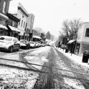
A few flakes here mixed with rain. Accumulating at the cog base station.