All Activity
- Past hour
-

2025-2026 ENSO
40/70 Benchmark replied to 40/70 Benchmark's topic in Weather Forecasting and Discussion
Solid Consensus for NDJ H5: -

July 2025 Obs/Disco ... possible historic month for heat
FlashFreeze replied to Typhoon Tip's topic in New England
As I read your post I am here in North Myrtle Beach and the wind has gone from an estimated steady 10 to 15 miles an hour to a steady 20 to 30 with gusts considerably over 40 possibly a little over 45mph, heavy squalls coming through now, more exciting than I thought it would be. -
Hello everyone, I normally post on the New England forum however I am in North Myrtle Beach and the weather has quickly deteriorated to heavy squalls and the wind has increased considerably in the last 30 minutes from an estimated 10 to 15 miles an hour to 20 to 25 with a couple of gusts that have been 40mph at least, I don’t have an anemometer however I think that is a pretty close estimate.
-
2025-2026 ENSO
40/70 Benchmark replied to 40/70 Benchmark's topic in Weather Forecasting and Discussion
Geez....even the CFS isn't warm for the NE next winter. That thing is usually run by a tag team of Bluewave and snowman. Looks a lot like the CANSIPS at H5. - Today
-
As Barry posted, flash flooding is the biggest concern from Chantal. This covers NE SC and SE NC. The main area of solid rain is just entering these areas:URGENT - IMMEDIATE BROADCAST REQUESTED FLOOD WATCH NATIONAL WEATHER SERVICE WILMINGTON NC 1250 PM EDT SAT JUL 5 2025 NCZ099-109-110-SCZ054-058-059-061215- /O.NEW.KILM.FA.A.0002.250705T1700Z-250708T0000Z/ /00000.0.ER.000000T0000Z.000000T0000Z.000000T0000Z.OO/ COLUMBUS-INLAND BRUNSWICK-COASTAL BRUNSWICK-COASTAL HORRY-CENTRAL HORRY-NORTHERN HORRY- INCLUDING THE CITIES OF MYRTLE BEACH, LONG BEACH, SHALLOTTE, OAK ISLAND, AYNOR, LONGS, SOUTHPORT, LORIS, BUCKSPORT, CHADBOURN, BOILING SPRING LAKES, GARDEN CITY, SOCASTEE, SUNSET BEACH, GREEN SEA, NORTH MYRTLE BEACH, LELAND, WHITEVILLE, LITTLE RIVER, TABOR CITY, LAKE WACCAMAW, AND CONWAY 1250 PM EDT SAT JUL 5 2025 ..FLOOD WATCH IN EFFECT THROUGH MONDAY EVENING * WHAT...FLASH FLOODING CAUSED BY EXCESSIVE RAINFALL IS POSSIBLE. * WHERE...PORTIONS OF SOUTHEAST NORTH CAROLINA, INCLUDING THE FOLLOWING AREAS, COASTAL BRUNSWICK, COLUMBUS AND INLAND BRUNSWICK AND NORTHEAST SOUTH CAROLINA, INCLUDING THE FOLLOWING AREAS, CENTRAL HORRY, COASTAL HORRY AND NORTHERN HORRY. * WHEN...THROUGH MONDAY EVENING. * IMPACTS...EXCESSIVE RUNOFF MAY RESULT IN FLOODING OF RIVERS, CREEKS, STREAMS, AND OTHER LOW-LYING AND FLOOD-PRONE LOCATIONS. * ADDITIONAL DETAILS... - HEAVY RAIN FROM TROPICAL STORM CHANTAL WILL INCREASINGLY EFFECT THE AREA LATE TONIGHT INTO SUNDAY. - WEATHER.GOV/SAFETY/FLOOD PRECAUTIONARY/PREPAREDNESS ACTIONS... BE ESPECIALLY CAUTIOUS AT NIGHT WHEN IT IS HARDER TO RECOGNIZE THE DANGERS OF FLOODING. YOU SHOULD MONITOR LATER FORECASTS AND BE PREPARED TO TAKE ACTION SHOULD FLASH FLOOD WARNINGS BE ISSUED.
-

E PA/NJ/DE Summer 2025 Obs/Discussion
RedSky replied to Hurricane Agnes's topic in Philadelphia Region
It's awesome a tropical depression came out of nowhere to swamp the region Monday and Tuesday. This arriving BEFORE the wet period slated to be starting on Wednesday. Totally awesome -
Today the new monthly Euro seasonal outlook was released for August and beyond in the ATL basin. Compared to the prior monthly forecast, which was near the avg for the active period 1993-2015 for # of TS+/# of H and very slightly above the avg ACE, the new one is very slightly less active with very slightly below the 1993-2015 avg for # of TS+/# of H and right at the active period’s ACE avg. The distribution of storms is similar to the prior forecast, which again suggests less activity from the NE Caribbean to Bahamas/FL/SE US/E Gulf vs last year’s horrendous season. It suggests near to very slightly below the active 1993-2015 activity in those regions. So, that wouldn’t mean quiet but instead less active than a terrible year. Fingers crossed this will be right, especially for FL/SE US, because another year like 2024 could be a real disaster for especially FL’s home insurance industry.
-

July 2025 Discussion-OBS - seasonable summer variability
SACRUS replied to wdrag's topic in New York City Metro
Highs: EWR: 90 LGA: 88 TEB: 88 PHL: 88 New Brnswck: 87 JFK: 86 TTN: 86 ACY: 86 BLM: 85 ** missing hourly/intra hours ISP: 84 NYC: 84 -
BOULDER’S WINDS AREN’T WHAT THEY USED TO BE Extreme gusts in Boulder and Front Range appear to be diminishing JUN 24, 2025 - BY DAVID HOSANSKY Throughout the 1960s, 1970s, and 1980s, wind gusts routinely topped 120 miles per hour (mph), as measured at NSF NCAR’s Mesa Lab in the foothills above southwest Boulder. But the city’s extreme downslope winds have seemingly slackened in the last 30 years, with observed peak gusts rarely approaching 100 mph after 1995. More research is needed to flesh out the reason for the decrease in peak gusts. But the paper suggests it may have to do with changes in atmospheric conditions. As global temperatures have become warmer, tropical storms are pumping more heat high in the atmosphere, affecting upper-level winds in the midlatitudes that could be changing the combination of atmospheric ingredients that produce strong wind gusts during powerful downslope wind events. “The difference in instrument location is part of the story, but the bigger picture probably has to do with changing conditions in the atmosphere,” https://news.ucar.edu/133028/boulders-winds-arent-what-they-used-be —————- Note that the year 1995 was stated as the cutoff point after which extreme gusts started to diminish. The +AMO/current active era/higher ACE for Atlantic tropical activity also started in 1995. Concurrently, the EPAC’s quieter ACE era started in 1995. Coincidence?
-

July 2025 Discussion-OBS - seasonable summer variability
psv88 replied to wdrag's topic in New York City Metro
87 today -
.thumb.png.4150b06c63a21f61052e47a612bf1818.png)
July 2025 Obs/Disco ... possible historic month for heat
HIPPYVALLEY replied to Typhoon Tip's topic in New England
I've got that one also, found it last summer at a local yard sale. I have a small collection of New England weather disaster books and ephemera. Collecting weather history and history in general is a great hobby. There are so many photos and stories that are not available through an internet search. -
That's crazy...
-

July 2025 Obs/Disco ... possible historic month for heat
FXWX replied to Typhoon Tip's topic in New England
I have the same magazine... Found it in a bookstore in Watch Hill, RI about 30 years ago! I never pass up the chance to browse through local bookstores when traveling. -
...FLASH FLOODING CONCERNS FROM CHANTAL SHOULD INCREASE OVERNIGHT... 11:00 PM EDT Sat Jul 05 Location: 32.7°N 78.8°W Moving: N at 8 mph Min pressure: 1004 mb Max sustained: 50 mph
-
VORTEX DATA MESSAGE AL032025 A. 06/01:05:50Z B. 32.45 deg N 078.72 deg W C. 850 mb 1482 m D. 1005 mb E. 015 deg 12 kt F. NA G. NA H. 26 kt I. 212 deg 44 nm 00:51:30Z J. 317 deg 20 kt K. 212 deg 54 nm 00:48:30Z L. 51 kt M. 051 deg 40 nm 01:18:00Z N. 147 deg 55 kt O. 051 deg 42 nm 01:18:30Z P. 17 C / 1519 m Q. 20 C / 1522 m R. 16 C / NA S. 12345 / 8 T. 0.02 / 15 nm U. AF303 0303A CHANTAL OB 03 MAX FL WIND 55 KT 051 / 42 NM 01:18:
-

July 2025 Obs/Disco ... possible historic month for heat
WxWatcher007 replied to Typhoon Tip's topic in New England
Was at an antique store and hit the jackpot. Found a magazine from 1938 documenting the Great Hurricane. The images are unbelievable. Happy birthday to me! -
Picked up .11" in 2 quick moving showers.
-
Terribly sad about the flooding. My best friends brother, Bill Huston, is one of the missing people.
-

July 2025 Obs/Disco ... possible historic month for heat
Torch Tiger replied to Typhoon Tip's topic in New England
Not bad outside at all, looking forward to tomorrow! -
The situation in Texas is so sad. I’ve had my own daughter away at a camp in recent weeks and can’t even imagine what those parents are going through
-
 Table of forecasts for July 2025 (not sure what happened to BKViking, I sent them a reminder which they acknowledged, but then no forecast ... anyway, here's what the rest of you predicted ...) FORECASTER __________________ DCA _NYC _BOS __ ORD _ATL _IAH ___ DEN _PHX _SEA RJay __________________________ +2.5 _ +2.5 _+2.5 __ +2.5 _+2.0 _+2.0 __ +2.0 _+2.0 _ +0.5 wxallannj ______________________ +2.2 _ +2.3 _+2.5 __+2.2 _+1.7 _ +2.5 __ +1.6 _ +0.2 _ +1.8 StormchaserChuck1 ___________+1.9 _ +1.9 _ +1.9 __ +1.5 _ +1.2 _ +1.3 __ +2.0 _ +2.3 _ +3.2 Roger Smith ___________________+1.7 _ +1.5 _ +1.3 __ +1.2 _ +2.0 _ +2.0 __ +0.3 _ +1.5 _ +0.7 so_whats_happening __________+1.5 _ +1.6 _ +2.1 __ +1.8 _ +0.8 _ +0.4 __ +0.2 _ +0.9 _ +2.0 DonSutherland1 _______________ +1.5 _ +1.5 _ +1.5 __ +1.5 _ +1.5 _ +0.5 __ +0.3 _ +1.2 _ +2.4 ___ Consensus _________________ +1.5 _+1.8 _+1.5 __ +1.6 _ +1.2 _ +0.7 __ +1.5 _ +1.4 _ +1.0 Scotty Lightning _______________ +1.5 _ +1.5 _ +1.0 __ +1.0 _ +1.5 _ +2.0 __ +1.0 _ +2.0 _ +1.0 Tom ___________________________ +1.5 _ +1.4 _ +1.5 __ +1.6 _ +0.8 _ +0.5 __ +1.1 _ +1.4 _ +0.8 hudsonvalley21 ________________ +1.3 _ +1.8 _ +2.1 __ +2.1 _ +0.6 _ +0.4 __ +2.1 _ +2.2 _ +0.9 wxdude64 _____________________ +1.1 _ +2.1 _ +2.5 __ +1.9 _ +0.7 _ +0.7 __ +1.2 _ +1.6 _ +2.7 ___ Normal ______________________ 0.0 __ 0.0 __ 0.0 ___ 0.0 __ 0.0 __ 0.0 ___ 0.0 __ 0.0 __ 0.0 RodneyS _______________________ -0.2 _ +0.4 _ +0.8 __ +0.4 _ -0.3 _ +1.7 __ +1.5 _ +0.1 _ +0.8 ___________________ Persistence _____________________+0.6 _ +1.2 _ +1.6 __ +3.6 _ +1.7 _ +1.7 __ +0.8 _ +2.2 _ +1.0 ============= Highest and lowest forecasts are color coded. Normal is lower than all forecasts for all locations except DCA and ATL.
 -

2025-2026 ENSO
so_whats_happening replied to 40/70 Benchmark's topic in Weather Forecasting and Discussion
It really has been interesting to follow more closely over the last 5 years how things have progressed. Im not ready to say the ITCZ is further north permanently or to be so going forward due to the warmer subtropics, as we had discussed about last season. It is noticeable of a change in overall TC behavior and numbers have changed a lot over the basins over the last half century or more. Colorado State keeps a pretty solid track of key things over each basin. https://tropical.atmos.colostate.edu/Realtime/index.php?arch&loc=northwestpacific The bolded has pretty been the most notable change we have seen associated with the changing of climate. I would like to make a similar timeframe for ENSO and PDO to each basin to see how years were effected more so than others. -

July 2025 Discussion-OBS - seasonable summer variability
Dark Star replied to wdrag's topic in New York City Metro
Rooftops are usually like driveways, much hotter than the grass surfaces. -
It is clearing up and the radar is dissolving into nothingness! We are in the clear! I want 90s and sunshine tomorrow! Should be perfectly dry and hot into Hallowe'en! Gotta WUB south central Texas!!!!!!!!!!! We do NOT have rain in Texas in summer. We get treated to 106 degrees, Egypt-like sunshine and heat indices near 120! Not one cloud! Rain be GONE! It's SUMMER now!
-

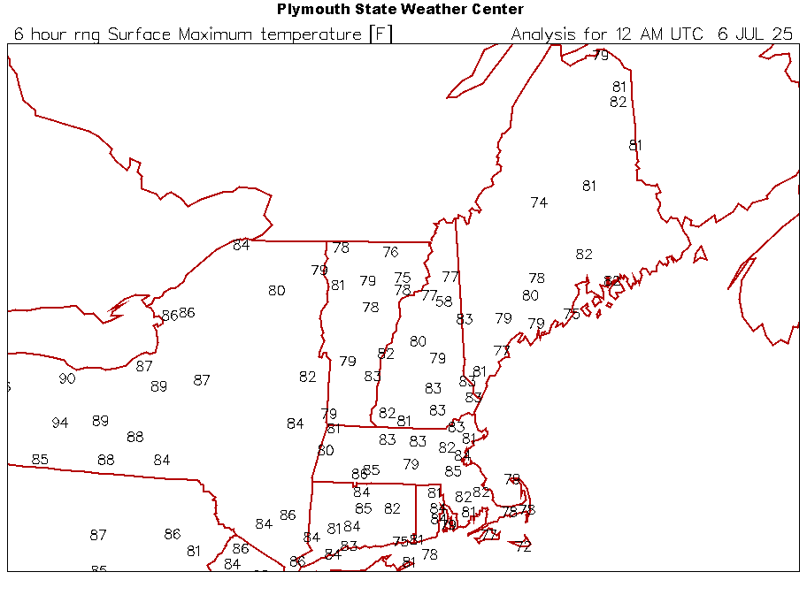
July 2025 Obs/Disco ... possible historic month for heat
powderfreak replied to Typhoon Tip's topic in New England
High of 79F up here today. Dews in the 50s for the most part but rising throughout the day to 60F this evening. A perfect summer day.