All Activity
- Past hour
-
Nice! Welcome to the other side of life Mike!
-
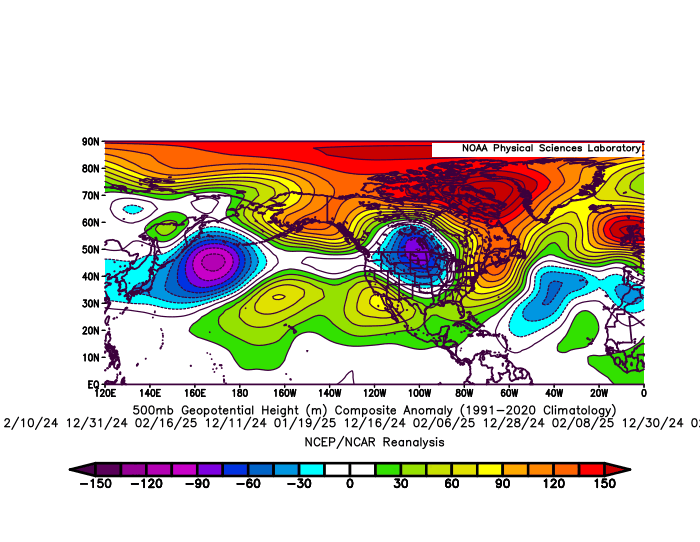
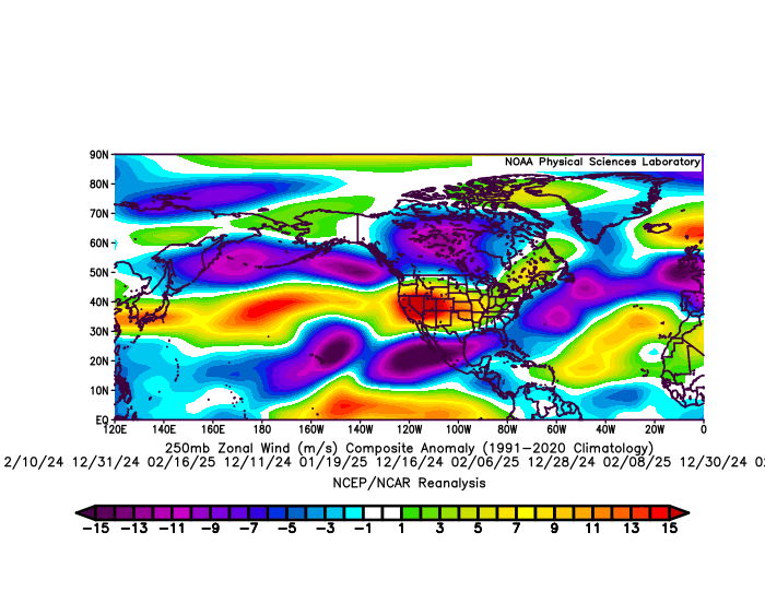
The storm track through the Great Lakes was pushed further north and east than usual resulting in the snowiest February on record in Toronto. So you needed to be far enough north to get into the really good stuff. Plus the record warmth and open waters around Hudson Bay kept the Great Lakes warmer than they typically see during La Ninas since the source region was so much warmer than normal. This residual pattern could have been lingering from the previous winter which was the warmest on record for many spots around the Great Lakes. The custom composites that I generated below isolate the storm track dates. These composites feature the 11 days this past winter that .20 or greater of precipitation fell around NYC Metro. So this was the dominant storm track for my area. The average temperature on these storm dates in NYC was 41°. It’s why the snowfall last winter was so low even though the average winter temperatures for the 3 month period was closer to 35.0°. The La Niña reference to the pattern is how strong the Southeast Ridge was along with the subtropical ridge from near Hawaii into the Southern Plains on the major winter storm track days around the Northeast. Also notice the familiar -NAO Greenland to Iceland block linking with the Southeast Ridge yet again. The extended Pacific Jet from Japan across the CONUS was also significantly stronger than past La Niña instances. My guess this is a result of the gradient between the record WPAC warm pool and Arctic cold in Siberia. So an enhanced La Niña pattern in some regards with variations leaving some areas of the Great Lakes drier and warmer than usual La Ninas.
-
whats with all the reds on that map lol
-
barrier islands maybe, not around here.
-
Interesting website... never heard or seen it before. What do you think of it?
-
Yes, these are my thoughts too and exactly what I'm hoping for. Variability is muted but eventually the elevated averages will win out and boost maximums to extreme levels. It's happening in the West first because they have dried out. But eventually water vapor won't be able to hold us back from our fate.
-
lol I have family there, been there dozens of times
-

June 2025 discussion-obs: Summerlike
LongBeachSurfFreak replied to wdrag's topic in New York City Metro
Winds already 15knots SSW at the beach. Seabreeze will keep the south shore significantly cooler today. -

2025 Short Range Severe Weather Discussion
CheeselandSkies replied to Chicago Storm's topic in Lakes/Ohio Valley
Could be looking at some action next week in the northern/western parts of the sub. -
Can't get much worse for mid June
.thumb.png.c79d55583e71a3b4c2aeb8d23895d5e8.png)
-

2025 Short Range Severe Weather Discussion
hawkeye_wx replied to Chicago Storm's topic in Lakes/Ohio Valley
The line of storms that moved ese-ward across northern Iowa yesterday produced a long path of 60-70 mph wind. They crapped out just north of me, but I still got 40 mph gusts from the outflow. -
Wow that is very informative comprehensive response
- Today
-

June 2025 discussion-obs: Summerlike
TheClimateChanger replied to wdrag's topic in New York City Metro
I did run my hypothesis by Grok, and he agrees that climate change can increase average temperatures in the summer while also lowering day to day variability. So this might explain why the data shows warming, while you remember more 95F & 100F days in the past. A sufficient increase in average temperature should be more than enough to overcome the lessened variance in the future. -
Upper 80s on tap for today. Should be the hottest of 2025, so far. The warmest reading observed this year at KPIT is 86F, on June 4th and on April 19th.
-

June 2025 discussion-obs: Summerlike
WeatherGeek2025 replied to wdrag's topic in New York City Metro
Hope you guys are doing good. Anyone have been having sore throat the last few days, i'm wondering if it has anything to do with the wildfires up north in Canada. I mean my throat just actually hurts! -

Central PA Summer 2025
Mount Joy Snowman replied to Voyager's topic in Upstate New York/Pennsylvania
Haha that's a great story. You seem like a top-notch bartender. I'll have to come in sometime when I can try one of your cocktails. My boss was darn close to ordering an old fashioned and had he done so, I would have quickly followed suit ha. But alas, duty called. Food was outstanding! -
Said like someone who’s never been there.
-
Actually, made it up to 95F at Des Moines yesterday, with a record-tying 96F at Waterloo, Iowa!
-
80 here too and the projected high for here is also 90 with westerly winds most of the day. a great day!!
-
Precisely, high temperatures. I prefer a Jacksonville climate vs Miami.
-
June 2025 discussion-obs: Summerlike
TheClimateChanger replied to wdrag's topic in New York City Metro
By hotter, I'm assuming you mean by maximum temperatures. By mean temps, Miami is about 2-3F warmer than Jacksonville. I would chalk that up to JAX having a more continental-influenced climate. While both are on the coast, Miami is at the tip of peninsular Florida. The increased latitude is less significant in the summertime, with insolation probably being about the same at both locations. -
Seriously, almost 80 degree DP in certain locations in the Midwest, wow !

-
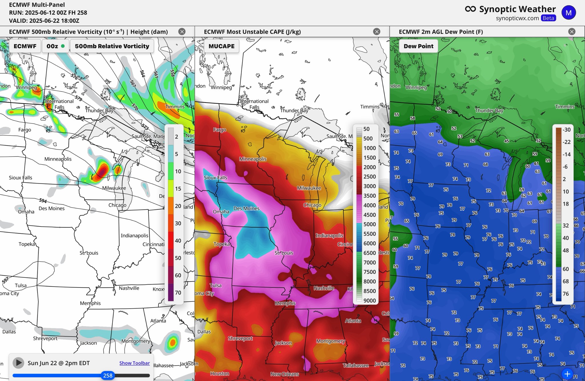
Finally it appears we are headed to a normal temp pattern, to at times above normal, with higher humidity levels. Eventually we may have the ingredients for a widespread severe weather threat in the Midwest and Mid Atlantic later in the month. Will post that in the severe thread.
.thumb.png.5fdd80031d97cda86e45686ec184e6bc.png)
-
June 2025 discussion-obs: Summerlike
TheClimateChanger replied to wdrag's topic in New York City Metro
Although I think Bristol, Tennesee is probably a better analog. 20 years ago, a regression from 1960 shows very little increase in 90+ days. The same regression run through 2024 now shows an increase of more than 3 weeks of such days. Definitely illustrates the folly of extrapolating from an existing trend without looking at what's going on behind the data. If one had examined the Bristol data closely, they would have noted an increase in the mean high temperature but found the increase in 90+ days somewhat offset by a decrease in internal variability [i.e., day-to-day variance]. So once normal highs climbed a bit more, the number of 90+ days exploded in the last 20 years. 1960-2004 1960-2024 -
Miami's average high was probably already mid to upper 80s so a couple degrees increase in averages puts their number of 90+ degree days way higher. They probably had a ton of days maxxing out at 88 or 89 and now they have all those days maxxing out at 90 or 91 instead.


.png.8b2966da9569fc39b4a1bd1d9551968a.png)


.png.64a71842936853b15210e2c96efb2e88.png)