All Activity
- Past hour
-

December 2025 regional war/obs/disco thread
Ginx snewx replied to Torch Tiger's topic in New England
If one could only see soundings. Oh wait at least at my point and click 6Z Euro is isothermic below 0C with a very unstable convective airmass . Why would you toss the best model?.thumb.jpg.37ab84e6c52947c88ffcd5e04f18c104.jpg)

-

December 2025 regional war/obs/disco thread
Baroclinic Zone replied to Torch Tiger's topic in New England
Thread hath been giveth. -

Nov 28-30th Post Turkey Day Wintry Potential
OrdIowPitMsp replied to Chicago Storm's topic in Lakes/Ohio Valley
NWS feeling a lot more bullish than I am in Minneapolis. I think 1-2” is a reasonable call, they seem to think 2-5”. Either way, glad to see a deep freeze behind the snow. Get those lakes frozen already! -
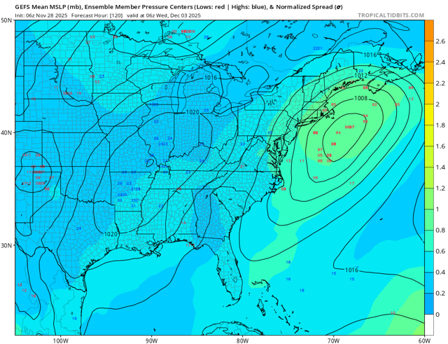
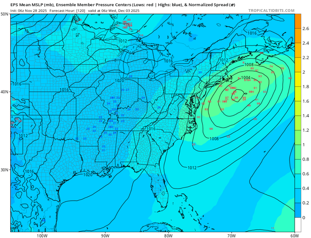
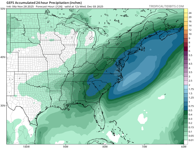
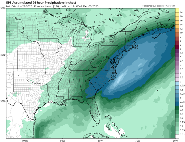
So we’re 4-5 days out from our first winter storm of the season. Models are pretty consistent in bringing surface low off coast and traversing across the area. Prior to storm we have a cold front that pushes through proving antecedent airmass. This cold unfortunately won’t be locked in place. High pressure while initially in a pretty good spot just north of the area will be retreating allowing warmer air to intrude. Overall a pretty classic storm setup. With storm being so early in the season, areas inland and with elevation will be more favorable for staying on the snowier side while coastal areas will see perhaps an initial burst of snow but transitioning to rain as warmer air intrudes. The storm is pretty juiced up so we could see some seeing 6-10” snow out of this and those on the wet side seeing 0.5-1.0” of rain. Below are the latest 06z EPS and GEFS ensembles showing tracks and 24hr mean QPF.
-
Temps fluctuated last night. Dropped to 30 by 1:30 am. Then rose to 35 by 4:00 am before dropping again to 28 by 6:00 am. Got above freezing by 8:00 am. Light frost due to temp fluctuation but our first frost and temp in the 20's. Not sure if that would considered a hard freeze or not.
-
Records: Highs: EWR: 72 (2011) NYC: 70 (2011) LGA: 68 (1990) JFK: 66 (2001) Lows: EWR: 16 (1932) NYC: 15 (1930) LGA: 21 (1951) JFK: 21 (1996) Historical: 1796: It is so cold that the freezing of the ink on the point of my pen renders it difficult to write. (Monticello - Thomas Jefferson to Thomas Mann Randolph) (Jefferson's Garden Book page 252 by Edwin Morris Betts) 1905: A Great Lakes storm produced winds at Duluth, MN of over 60 mph for more than 12 hours. Sailors aboard a ship which went aground just 100 yards offshore in Lake Superior actually froze to death. (Ref. AccWeather Weather History) 1921 - New England was in the midst of a four day icestorm, their worst of record. Ice was more than three inches thick in many places following the storm, and property damage was in the millions of dollars. Northern New England received heavy snow with more than two feet reported in some areas. Overnight freezing rains continued through the day at Worcester MA while the wind increased to a gale. Streets become impassable even on foot, and whole towns were plunged into darkness without communication. The storm caused 20 million dollars damage to power lines, telephone lines and trees. (David Ludlum) Up to 4 inches freezing rain on E half of MA. Approx 2 tons of ice on wires between some telegraph poles; 2,700 poles fell on 1 railroad in the 60 miles W of Boston. In Worcester 50 feet high pine trees held 5 tons of ice; some deaths due to falling trees/ice. (Ref. Weather Guide Calendar with Phenomenal Weather Events 2011 Accord Pub. 2010, USA) 1932: Boston, Massachusetts recorded its highest November pressure of 30.87 inches of mercury. (Ref. NOAA Boston Weather Events) 1955: A bitterly cold arctic air gripped areas from the southern Plains to the Great Lakes. The high temperature at Lansing was only 15° (a record low maximum), after a morning low of 6°. Meanwhile, a foot of lake effect snow piled up at Muskegon, MI. Other locations reporting record lows included: Green Bay, WI: -3°, Houghton Lake, MI: 0°, Marquette, MI: 0°, Toledo, OH: 6°, Muskegon, MI: 7°, Grand Rapids, MI: 7°-Tied, Youngstown, OH: 7°-Tied, Cleveland, OH: 8°, Detroit, MI: 8°, Springfield, MO: 10°, Evansville, IN: 12°, Paducah, KY: 13°. (Ref. Wilson Wx. History) 1960 - A severe storm produced waves 20 to 40 feet high on Lake Superior. Duluth, MN, was buried under a foot of snow, and clocked wind gusts to 73 mph. The northern shore of Lake Superior was flooded, and property along the shore was battered. Thousands of cords of pulpwood were washed into Lake Superior, and up to three feet of water flooded the main street of Grand Marais. Thunder accompanied the nor'easter . (David Ludlum) (The Weather Channel) 1975: The first winter storm of season was a heavy one across southern California ending the next day. Up to two feet of snow fell in the San Bernardino Mountains, including 16 inches at Big Bear Lake. 20 stranded campers were rescued after a few days. 12 inches of snow fell in Idyllwild, tying their greatest daily snowfall on record for November (11/10/1982). (Ref. Wilson Wx. History) 1978: A jockey at a horse racing track in Miami, FL was killed by lightning as he ran for cover after a race. (Ref. Wilson Wx. History) 1987 - Low pressure in the Middle Mississippi Valley produced a mixture of snow and sleet and freezing rain from the Central Plains to the Upper Mississippi Valley. Snowfall totals in Iowa ranged up to ten inches at Red Oak. Totals in Nebraska ranged up to 11 inches at Shickley. Freezing rain made roads treacherous in the Twin Cities area of southeastern Minnesota. Bitter cold arctic air invaded the Northern High Plains Region. Laramie WY was the cold spot in the nation with a morning low of 18 degrees below zero. (The National Weather Summary) (Storm Data) 1988 - Thunderstorms spawned five tornadoes in North Carolina during the early morning hours. A powerful tornado ripped through one of the most densely populated areas of Raleigh destroying hundreds of homes and damaging thousands more. The tornado killed four persons along its 83 mile track, and injured 154 others. Total damage was estimated at more than 77 million dollars. (Storm Data) (The National Weather Summary) 1989 - Strong Santa Ana winds prevailed across southern California. Winds gusted to 70 mph at the Rialto Airport, and several tractor- trailer trucks were overturned east of Los Angeles. High winds also buffeted the northeastern U.S., ushering arctic air into the region. Winds gusted to 60 mph at Montpelier VT, and reached 66 mph at Saint Albans VT. (The National Weather Summary) (Storm Data) 2005: 26th - 28th November, Great Falls, Montana Great Falls experiences its heaviest snowstorm on record with a three-day total of 18.1 inches. 24.9 inches of snow for the month made it the snowiest November on record. (Ref. WxDoctor) 2006: A slow moving storm system brought heavy snow to the mountains and the Eastern Foothills of Colorado where snowfall totals ranges from 8 to 18 inches. Some of the higher totals included: 18 inches at Genesee, 17.5 inches near Boulder, 17 inches at Aspen Springs, 15 inches at Eldorado Springs, 14.5 inches near Jamestown, 12 inches near Indian Hills, 11.5 inches near Blackhawk, 11 inches at Gross Reservoir & Eldora and 10.5 inches at Conifer. Across the Denver Metro area 5 to 9 inches fell with the heaviest amounts near the Foothills. Higher storms totals included: 15.5 inches at Ken Caryl, 12 inches at Boulder, 7.5 inches near Morrison and 7 inches near Chatfield and Ralston Reservoirs. (Ref. Wilson Wx. History)
-
BWI 21.6 DCA. 12.4 IAD 24.5 RIC 11.6 SBY 12
-
It looks like a nice snowpack is going to be laid down like a frozen carpet in southern Canada and New England. As much as I want to cash in on one of these first systems, we know it’s a process and stocking the freezer to our north only helps. Hopefully in a week or two we’ll get a real crack at a storm and not need a 1040 high to make or break it.
-
.thumb.png.e28622a101ead8a503efd5015c7d3862.png)
Nov 28-30th Post Turkey Day Wintry Potential
Weather Mike replied to Chicago Storm's topic in Lakes/Ohio Valley
I'm in Tampa on a layover, ORD this afternoon and then hunker down. We need Saturday afternoon to deliver an inch an hour to get us 9+. If we can get 3 by noon .5/hr for 6 hours we will be in good shape. Funny I am in Miami waiting to fly to ORD. Can’t wait for some snow on Saturday in Chitown. Good luck to everyone and today’s model runs ! -

December 2025 regional war/obs/disco thread
HoarfrostHubb replied to Torch Tiger's topic in New England
Gonna be a long winter for some. Anyway, I personally would prefer the snow held off for a week or so, but what falls, falls (or drips) -
37 / 19 mainly clear - windy today. Overall colder than normal with brief warmups and several systems/storms through the next 2 weeks (12/13). Some very below normal temps during the perioded netting a strong negative departure and potential snow/mixes.
-
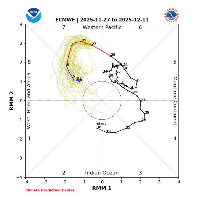
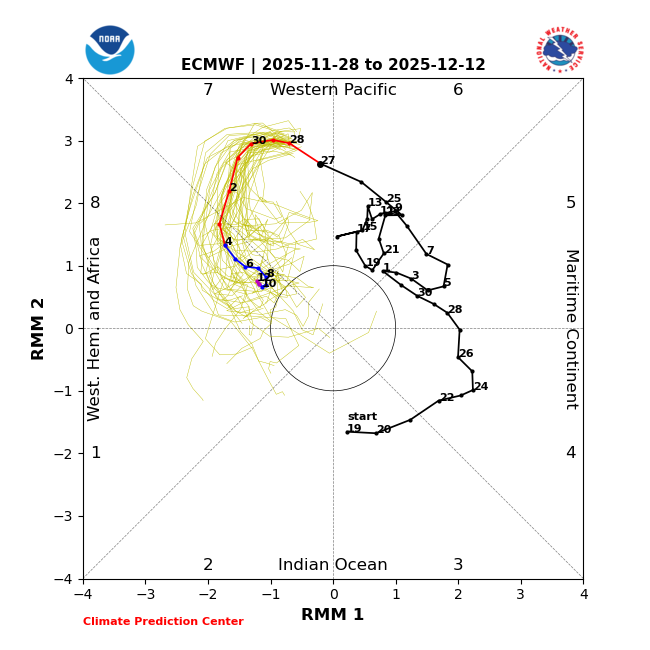
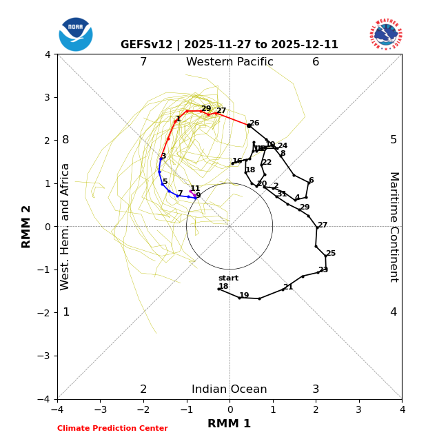
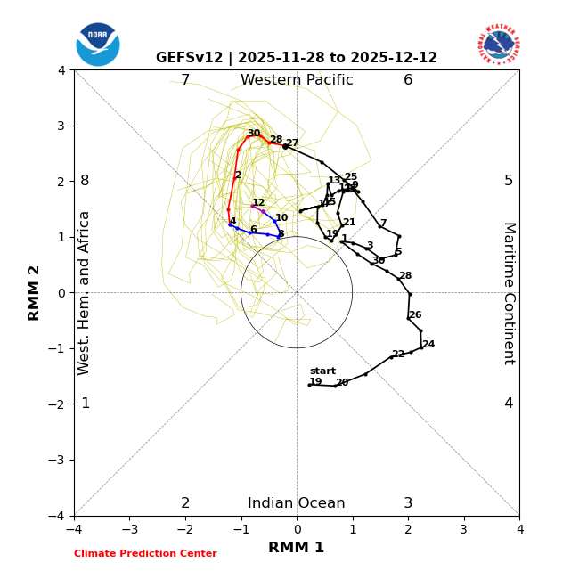
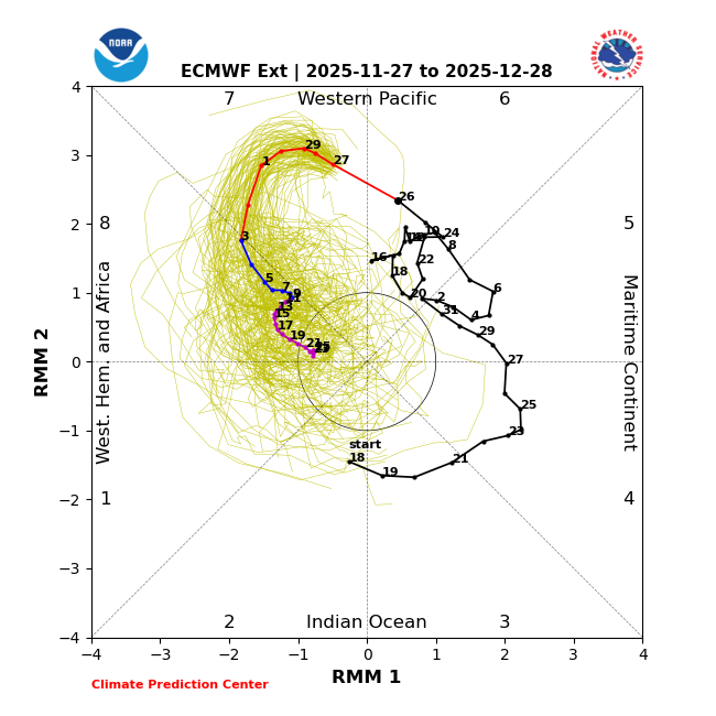
MJO: Yesterday’s EPS: Edit: Adding yesterday’s ext-EPS: record shattering 26 day phase 8 (current record 18 days)! Today’s EPS excellent consistency with yesterday with a very long (10+ day) long phase 8: Yesterday’s GEFS: Today’s GEFS hopefully this is off as it went from yesterday’s similar to Euro very long phase 8 to no phase 8 through at least Dec 12th: In summary, mixed results today: fantastic EPS and not so good GEFS. Hoping EPS will end up the winner for today’s runs!

-
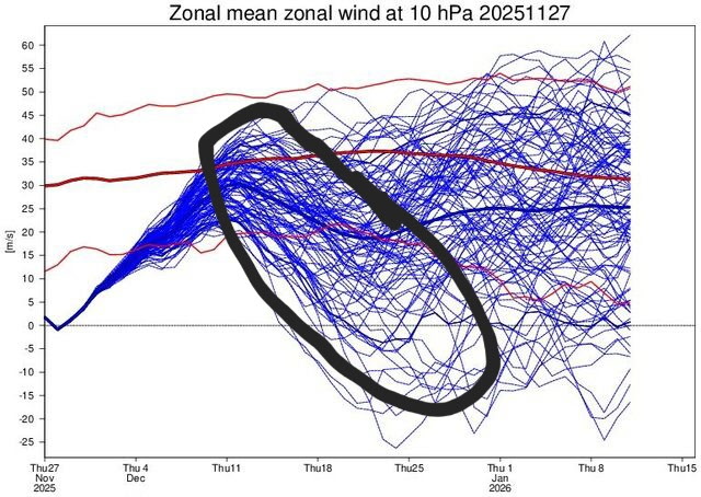
That proves absolutely nothing. It is still a classic wave reflection event. Nothing has changed. It’s nowhere close to a major SSWE, total wind reversal and an SPV split. Read the tweets I posted from real meteorologists. But if you want to believe the hype from a quack from PA who failed out of met school, go right ahead
-
That timeframe should be watched.
-
While no wind thread today... am getting a tracking thread started for Tuesday by 930AM,
-

December 2025 regional war/obs/disco thread
TauntonBlizzard2013 replied to Torch Tiger's topic in New England
Some personal attacks too. Hate to see it. Weather is serious business I guess -
With those 925 borderline temps and heavy precip, Phil is coming for someone.
-
December 2025 regional war/obs/disco thread
HoarfrostHubb replied to Torch Tiger's topic in New England
So much anger in here -

December 2025 regional war/obs/disco thread
weatherwiz replied to Torch Tiger's topic in New England
All things aside, both the Euro and GFS (at verbatim) would produce a pretty solid band of heavy snow. Way too early to really worry about the details and specifics. But in terms of potential snowfall amounts...it may be tough to get widespread warning criteria (maybe just barely warning snows but also depending on what's going on with the band and snowfall rates) due to how quickly it is moving but it's December 2nd and we're talking about potential for a large area to receive accumulating snow. -
December 2025 regional war/obs/disco thread
TauntonBlizzard2013 replied to Torch Tiger's topic in New England
I’d like to Be around Hubbs area. Bet his area up to Southern Vermont will do very well, up through dendrite and over to dryslot. -
Someone is definitely getting a paste job. It’s close to Kevin and Ray.
-
The PV is not strengthening. You have been burned before thinking that
-
Yup I agree. But injury's don't cause turn overs or the defense to implode lol
-
It starts moving in Tue morning. So we’re at about 4-4.5 days.
-

December 2025 regional war/obs/disco thread
Damage In Tolland replied to Torch Tiger's topic in New England
Completely wrong. Today is already here. You don’t count today lol
.jpg.f965a6f09b655d7dea6f31ae7cf7dbff.jpg)


