All Activity
- Past hour
-
Heck of a temp rise overnight from 32 degrees at about 2am to 43 currently.
-
banger season for the sierra, rest of the intermountain west naso much
-

Winter 2025-26 Short Range Discussion
A-L-E-K replied to SchaumburgStormer's topic in Lakes/Ohio Valley
tone sincere, would love to -
What the f are you going on about fool?
-
I mean there is some spread north, but it has that oblong shape meaning it’s probably more a N-S elongation or trough extension like euro op has.
-

Feb 10-11 Mid Week Minor Event - Ride the hot hand?
Ginx snewx replied to HoarfrostHubb's topic in New England
Radar across the east looking south of global models -

Feb 10-11 Mid Week Minor Event - Ride the hot hand?
CoastalWx replied to HoarfrostHubb's topic in New England
Sorry, I meant what it has for advisories. they should at least have north of the pike. -

Feb 10-11 Mid Week Minor Event - Ride the hot hand?
moneypitmike replied to HoarfrostHubb's topic in New England
I think GYX is being way too aggressive here. P/C is for 3-7. -
Feb 10-11 Mid Week Minor Event - Ride the hot hand?
Ginx snewx replied to HoarfrostHubb's topic in New England
Tell us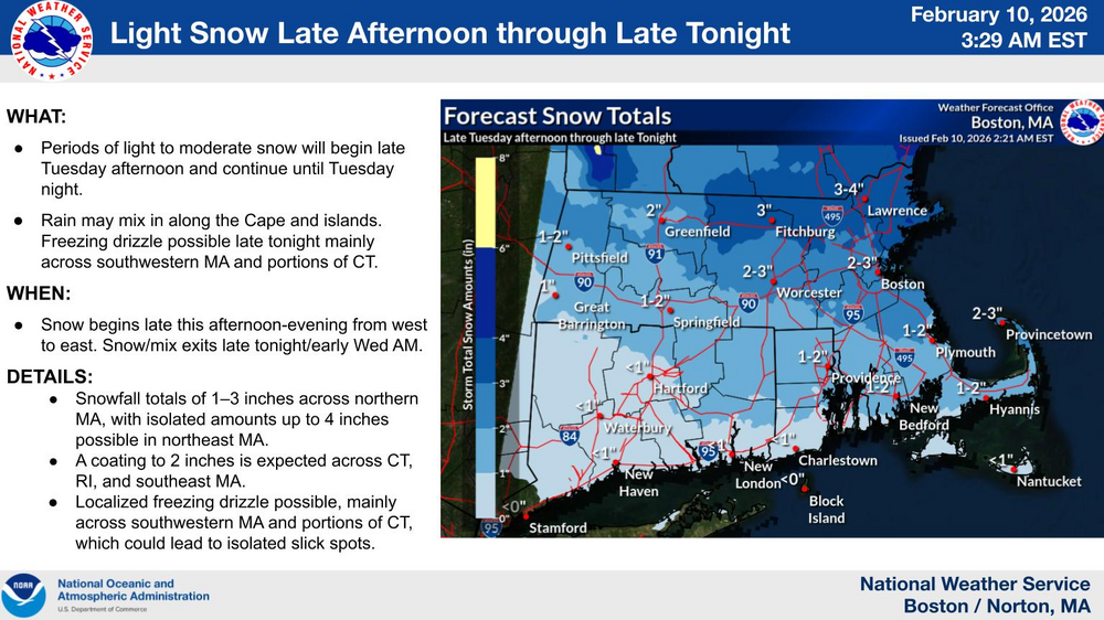
-

Winter 2025-26 Medium/Long Range Discussion
Baum replied to michsnowfreak's topic in Lakes/Ohio Valley
Stick a fork in it. -

Feb 10-11 Mid Week Minor Event - Ride the hot hand?
HoarfrostHubb replied to HoarfrostHubb's topic in New England
Snowing now. A coating to 0.25” -
Feb 10-11 Mid Week Minor Event - Ride the hot hand?
CoastalWx replied to HoarfrostHubb's topic in New England
BOX map is bizarre. Anyways hoping 2-4 here. -
Watching models this season is like watching Angel Hernandez ump an MLB game
-
Winter 2025-26 Medium/Long Range Discussion
A-L-E-K replied to michsnowfreak's topic in Lakes/Ohio Valley
Winter about done? -
Yeah the Ukie is.
-
.thumb.jpg.6a4895b2a43f87359e4e7d04a6fa0d14.jpg)
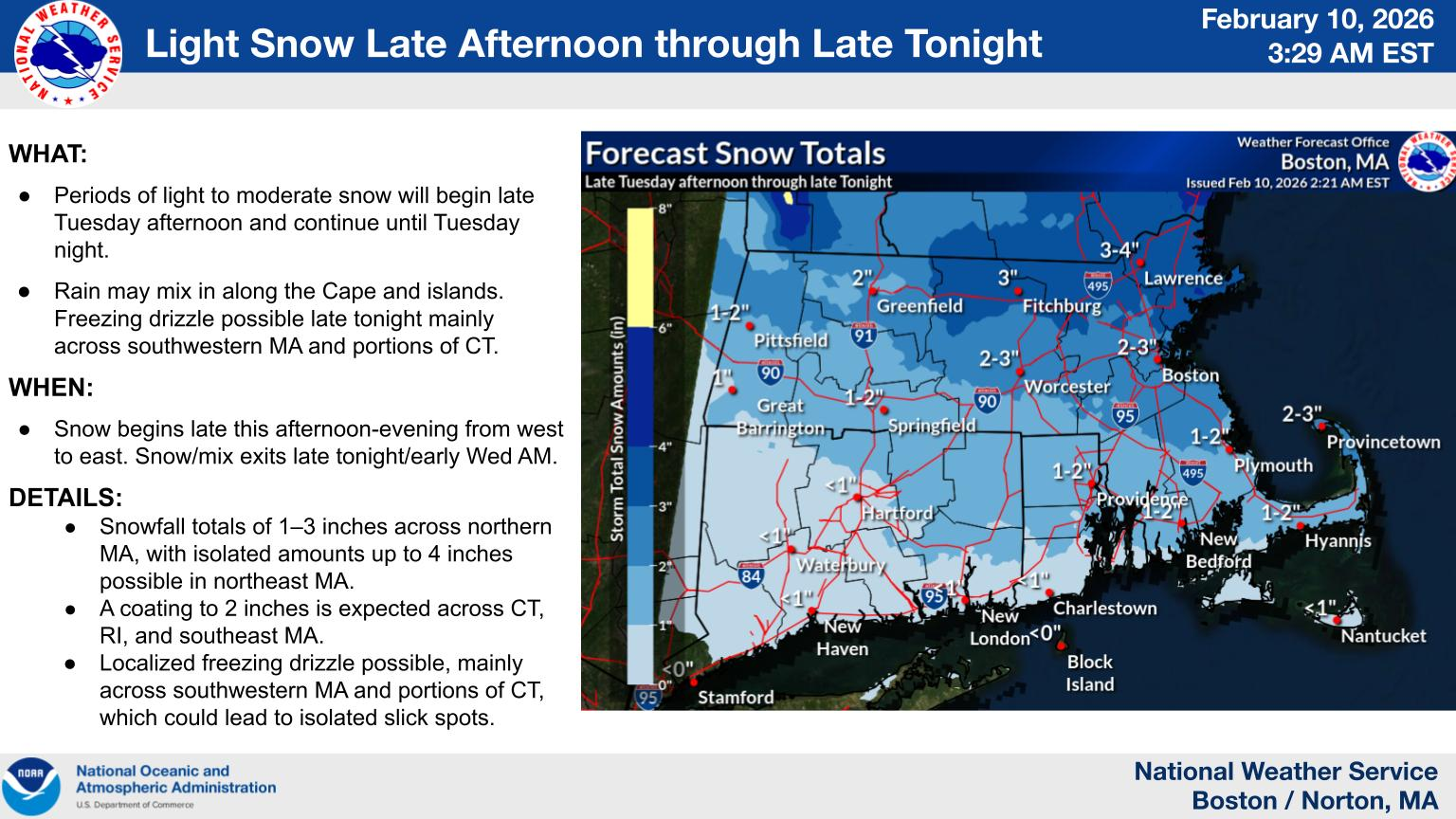
Central PA Winter 25/26 Discussion and Obs
Yardstickgozinya replied to MAG5035's topic in Upstate New York/Pennsylvania
The good news is NWS has Increased their confidence in a winter storm during Sun-Mon timeframe. The bad news is NWS has lowered confidence in the occurrence of precipitation Sun-Mon. Once again they're getting all the angles covered. Area Forecast Discussion National Weather Service State College PA 444 AM EST Tue Feb 10 2026 .WHAT HAS CHANGED... * Increased confidence in winter storm during Sun-Mon timeframe * Holding off on any winter weather advisories for possible ice accums for E/NE this evening-SW later tonight && .KEY MESSAGES... 1) Light precip possible later today and this evening, with light post-frontal snow showers and gusty winds over the Alleghenies later tonight through Wednesday night. 2) Lowered confidence in occurrence of precipitation Sun-Mon. Confidence in timing of possible precip is slightly higher. Confidence in precip types/amounts remain low -
It’s always fascinating to track how active weather patterns evolve from month to month and how different systems interact across regions. April can bring a wide range of conditions, so sharing observations helps us all understand broader trends better. Do you usually notice a shift in storm behavior this time of year where you’re located, and do travel plans around weather ever affect your rides with services like sallimoservice?
-
 The euro really caved to the euro ai it seems. Good to know! But yeah this period is just too warm.
 - Today
-
Good bye and good luck.
-
Central PA Winter 25/26 Discussion and Obs
Yardstickgozinya replied to MAG5035's topic in Upstate New York/Pennsylvania
Well, I'll be d***** . Looks like that might be able to sneak in here.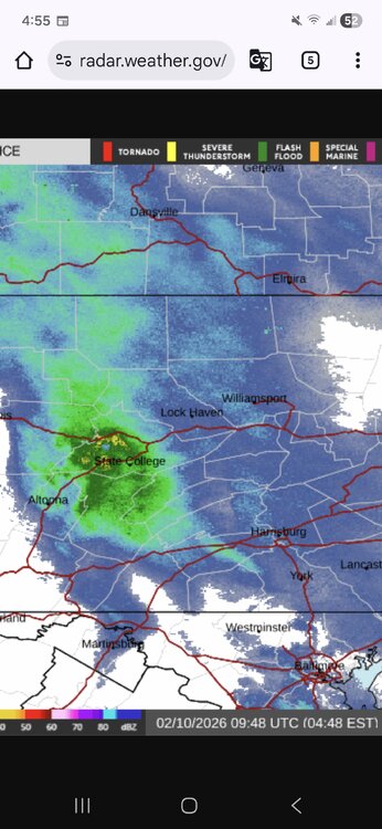
-
 Remember last week when I said you all are tracking a rainstorm and I was accused of negativity and whining and now 5 days of models runs later and you admit that I am in fact....... Correct.
 -
Isnt he allowed to twerk on a pole without you objectifying him??!?!?!
-
Inside on a computer in air conditioning? Lol
-

Feb 10-11 Mid Week Minor Event - Ride the hot hand?
wxsniss replied to HoarfrostHubb's topic in New England
6z NAM / RGEM solid 2-4 / 3-6 east RGEM has been pretty good this winter and relatively steady for Tuesday -

2026-2027 El Nino
Stormchaserchuck1 replied to Stormchaserchuck1's topic in Weather Forecasting and Discussion
This is a time sensitive ENSO subsurface anomaly map, and 5-day subsurface temperature trend. It will always be updated to the most recent day.