All Activity
- Past hour
-
Typical onset of El Nino conditions
-
Maybe the tide is turning .
-

Roger Smith, who ran our seasonal forecast contests, passed away
FPizz replied to GaWx's topic in Tropical Headquarters
Oh wow, sad to read this -

2026-2027 El Nino
40/70 Benchmark replied to Stormchaserchuck1's topic in Weather Forecasting and Discussion
Doesn't have to be west-based necessarily to have that type of outcome.....basin-wide is fair game. That year was also emerging from a persistent -PDO. I've already said I don't expect next winter to be that cold, regardless, but my point is that I don't think a +5F season is a foregone conclusion. -

2026-2027 El Nino
Great Snow 1717 replied to Stormchaserchuck1's topic in Weather Forecasting and Discussion
It should scare every winter enthusiast... -

2026-2027 El Nino
Stormchaserchuck1 replied to Stormchaserchuck1's topic in Weather Forecasting and Discussion
You've mentioned 02-03 a few times but that was a major west-based Nino. I don't think we're going to have that orientation this year, and the Pacific is still in a -ENSO state, left over from what has been that phase generally since 2016. The Mountain West hitting >+10F anomalies for a 4-5 month period this Winter honestly scares me about cold Winter prospects next year. -
2026-2027 El Nino
40/70 Benchmark replied to Stormchaserchuck1's topic in Weather Forecasting and Discussion
I don't anticipate a super el nino just based on what has happened in the past and where it looks like we're headed...just doesn't fit. My guess is a decent event that is not prohibitive to a good winter...a la 1957 or 2002. Again, just my hunch....I'm not saying a super event can't happen, but considering we just had a super event in 2015, and a very strong and very warm el nino in 2023 as we now begin to emerge from the ongoing Pacific cold phase, I just don't see it. I like 1957 because it is a good QBO fit and decent solar match (albeit closer to solar max) that followed up two Pacific cold phase El nino events. 2002 is a very good solar match and an okay QBO match that also occurred as we emerged from a persistent -PDO. -

2026-2027 El Nino
roardog replied to Stormchaserchuck1's topic in Weather Forecasting and Discussion
Since I’ve never really paid too much attention to forecasts of WWB and Kelvin waves and that sort of thing, my question is, how accurate are those modeled forecasts going out a week plus normally? -

E PA/NJ/DE Spring 2026 Obs/Discussion
JTA66 replied to PhiEaglesfan712's topic in Philadelphia Region
We have this debate every couple of years. I suspect Mike was being a bit sarcastic, but I let him speak to that. My hunch is, if we combined forums, the Philly posters would eventually disappear. This is a backyard sport. Personally, I have little interest what the weather is doing in NYC. I'm mainly interested in obs from our local PA, south Jersey and northern DE posters. It gives me an idea of what's on the way, be it severe weather, the changeover line or what not. I'd prefer to not have to waddle through hundreds of posts about the Mets pitching staff to find out how quickly the changeover line is progressing through the region. -My respectfully submitted opinion (but I'm just another nobody weenie). -
2026-2027 El Nino
Stormchaserchuck1 replied to Stormchaserchuck1's topic in Weather Forecasting and Discussion
There might be a tendency to exaggerate very favorable conditions, and immediate jump to Super Nino vs something Moderate or even Strong.. like I've previously posted, the March SOI has never been this high in a Moderate+ Nino later in the year. Now there's only 9 examples and I'll have to test it back before 1950, but things are less than ideal right now, although SSTAs are warming pretty fast. Just some random thoughts this morning. Nino 4 also has a steady long term uptrend since 1950, more uniform than other regions.. that Nino 4 is already +0.4 and WWBs happening in the west, may propel that to some warmer conditions this year. -

Chester County PA - Analytical Battle of Actual vs. Altered Climate Data
chubbs replied to ChescoWx's topic in Climate Change
Yes, here's a good example of cherry picking. Don't worry, I'll be adding other stations. Why would the results change?. The other stations all have much shorter record lengths. Furthermore the modern stations are all warming rapidly in complete agreement with recent Coatesville and Phoenixville data.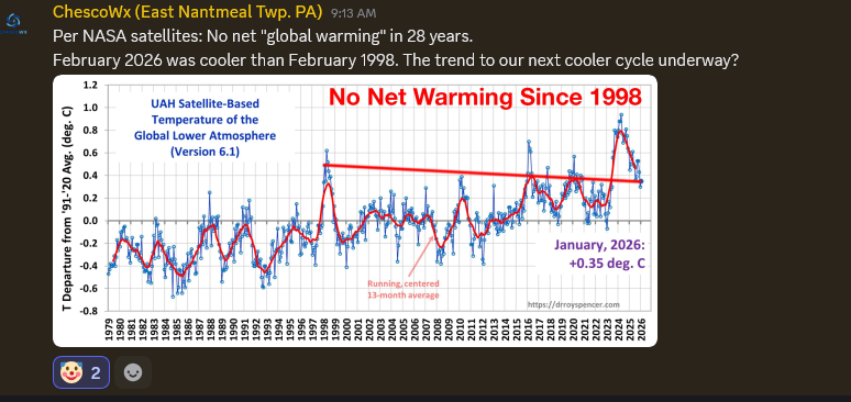
-
March 26 2012: This is the record early ice-out date on Mille Lacs Lake. 2007: Temperature records are shattered across much of central and southern Minnesota and west central Wisconsin. The following records were set: 69 at Alexandria, 75 at Mankato, 77 at Little Falls, 79 at St. Cloud, 81 at Minneapolis-St. Paul and Eau Claire, 82 at Redwood Falls, and 83 at Springfield. For Thursday, March 26, 2026 1913 - The Ohio River Basin flood reached a peak. Ten inch rains over a wide area of the Ohio River Basin inundated cities in Ohio, drowning 467 persons, and causing 147 million dollars damage. The Miami River at Dayton reached a level eight feet higher than ever before. The flood, caused by warm weather and heavy rains, was the second mostly deadly of record for the nation. (David Ludlum) 1954 - The temperature at Allaket, AK, plunged to 69 degrees below zero. (The Weather Channel) 1971 - Parts of northern and central Georgia experienced their worst snow and ice storm since 1935. Two day power outages ruined two million eggs at poultry hatches. Two persons were killed when a tree landed on their car. (25th-26th) (The Weather Channel) 1987 - A cold front crossing the Plateau Region produced high winds in Utah causing some property damage. Winds gusted to 51 mph at Salt Lake City. (The National Weather Summary) (Storm Data) 1988 - Twenty cities in the southwestern U.S. reported new record high temperatures for the date. Afternoon highs of 73 degrees at Flagstaff AZ, 90 degrees at Sacramento CA, 95 degrees at Santa Maria CA, 95 degrees at Los Angeles CA, 99 degrees at Tucson AZ, and 100 degrees at Phoenix AZ set records for March. (The National Weather Summary) 1989 - The Easter Bunny brought record warm temperatures to the central U.S. while such records were still welcome. A dozen cities reported record warm readings, including Dodge City KS with an afternoon high of 88 degrees. Strong southerly winds gusted to 51 mph at Dodge City, and reached 55 mph at Salina KS. (The National Weather Summary) (Storm Data) 1990 - Fair weather prevailed across the nation for the second day in a row. Freezing temperatures were reported in the Middle Atlantic Coast Region in the wake of an early spring snowstorm. Afternoon highs were again in the 70s and 80s in the southeastern U.S., and for the ninth day in a row, temperatures in the southwestern U.S. reached the 90s. (The National Weather Summary)
-
Saw my first flash of the year in the Feb 18 blizzard. Thundersnow is very cool!
-
You can even see it doing it over the top of Kevin's house in CT... It'll probably dry out some but just sayn' a-nnoying
-
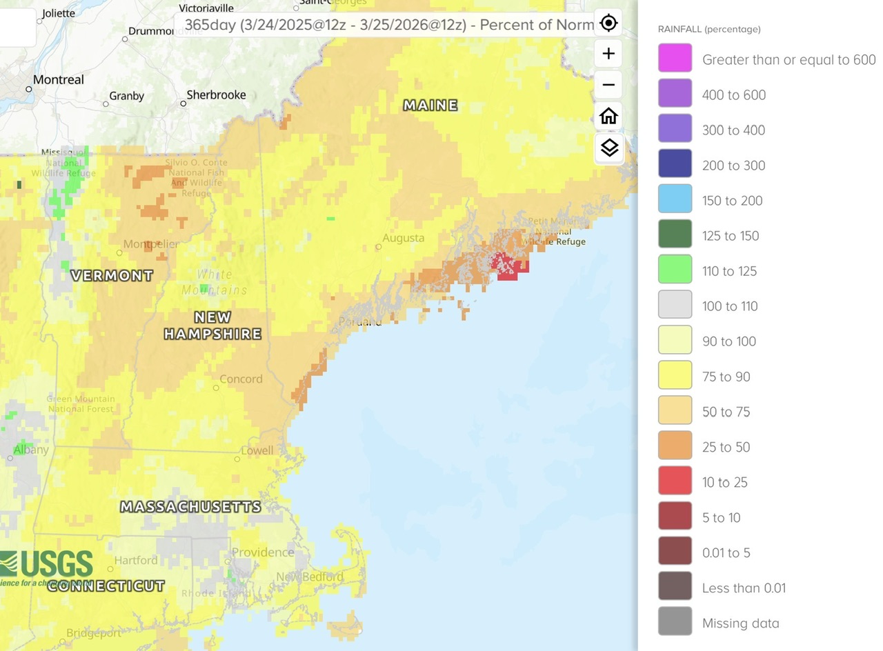
Scoot’s favorite just released. Looks similar to the shading of the 365 day departures.

-
It's the na na na-na na cloud line affect
-
Drives me wild continually seeing clouds moving W-E with blue sky to the west and it never arrives. You can actually see the clouds reforming with the naked eye.
-
Hopefully the predecessor to an endless string of tropical systems this summer
-
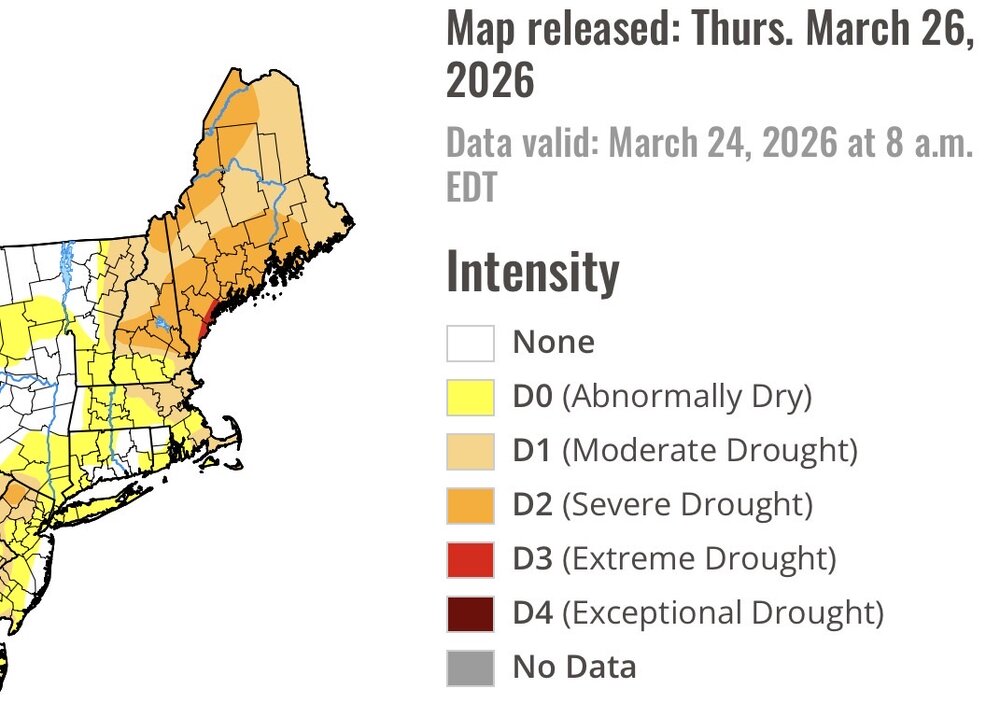
It isn't just us. Much of the West is in real trouble with all time record low snowpack.
-

2026-2027 El Nino
snowman19 replied to Stormchaserchuck1's topic in Weather Forecasting and Discussion
-
My concern for you all is the snowpack being at all time record lows in many spots across the West and what that will mean for water supply and fires.
-
We're getting that standing wave cloud production that Brian was complaining about the other day, down here. It happens more frequently up there than down here, but I've seen this before... It takes a conditionally unstable layer around 800 mb running down with the flow, and as it bumps up and over the terrain there is back-building schmootz. Loop vis sat, it looks like it's emerging out of seam. And summarily, optimistic forecasts bust. great
-

Central PA Spring 2026 Discussion/Obs Thread
Itstrainingtime replied to Voyager's topic in Upstate New York/Pennsylvania
Happy Opening day to any and all baseball fans. I have tickets for exactly 35 games so far between Baltimore, Philly, Pittsburgh, Detroit and Chicago. Gotta get my fix in now with the lockout looming... -
Such is April. Never expect nice Spring weather until May.
-
Central PA Spring 2026 Discussion/Obs Thread
Itstrainingtime replied to Voyager's topic in Upstate New York/Pennsylvania
Something else that hasn't happened much at all recently...the rainfall amounts for tonight have actually trended upwards over the past 24-48 hours.