All Activity
- Past hour
-

Spooky Season (October Disco Thread)
powderfreak replied to Prismshine Productions's topic in New England
Don’t worry, the time of getting 3” of snow and then 70 degrees a day later is coming up in December. - Today
-
Today was the first breezy day in a long time. It seems like the last month has been dead calm almost every day. It has been extremely warm, but it's very different than the heat a couple months ago. If the sun goes behind a cloud or the wind kicks up, it's suddenly comfortable. Also, by late afternoon it's already cooling off. By evening, it feels amazing. There is a big construction project by my house that has been ongoing since July, in which tens of thousands of yards of soil has been excavated and moved around. They have been very lucky to have such dry weather over the last several weeks. They are about to start work on the end of my street. Hopefully, they can get it done before the weather becomes more active.
-

2025 Atlantic Hurricane Season
WxWatcher007 replied to BarryStantonGBP's topic in Tropical Headquarters
That’s by far the worst spot too given the OHC and reduction in shear. There’s too much shear for the lemon areas in the Gulf right now, but the tropical Atlantic wave is likely to develop given how convectively active it continues to be and the CAG could very well produce 1-2 TCs (more likely 1 imo). -

October 2025 Discussion and Obs
BobbyHolikWillFindYou replied to wdrag's topic in New York City Metro
Plot twist...its all sleet. -
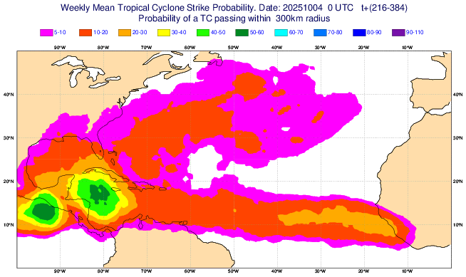
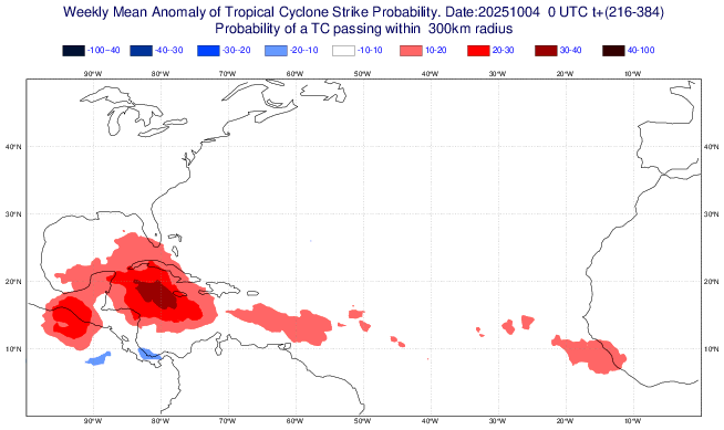
The latest Euro Weeklies are the most active yet in the W Caribbean for the week of 10/13-19 (if I were in the FL pen., especially S half, I’d be pretty concerned for midmonth): Forecast nearby TC probabilities: Forecasted anomalies vs 2005-24 climo: wow!
-
Yeah almost everything was still open. It was almost as busy there today as a summer day. Perfect weather for it. We always go a few times during July and August on Wednesdays because they have fireworks on Wednesday nights, but it's nice to go down there one more time during the early fall before things close down. Almost everything will be closing after next weekend. But anyway just to get back to what we were talking about with the Belmar forecast. I see Belmar had a high temp of 82 today, so we were right about the NWS forecast of 72 being ridiculously low. It felt like summer this afternoon walking up and down the Seaside Heights boardwalk.
-
The latest Euro Weeklies are the most active yet in the W Caribbean for the week of 10/13-19 (if I were in the FL pen., especially S half, I’d be a bit concerned for midmonth): Forecast nearby TC probabilities: Anomalies vs 2005-24 climo: wow!


-
Highs: EWR: 87 TEB: 86 New Brnswck: 86 LGA: 83 ISP: 83 TTN: 83 BLM: 82 PHL: 82 NYC: 82 ACY: 81 JFK: 78
-
There will continue to be persistent moderate NE and then E winds during the upcoming few days followed by a freshening of them from the NE late week from a new surface high. In addition, there’s a full moon on Tue (10/7) and perigee on Wed (10/8). As a result of the moon, astronomical tides are progged to be the highest of 2025 so far Oct 7-10. Because these already quite high tides are going to combine with the current and upcoming week’s winds, as well as a stronger surge of NE winds Thu/Fri, there’s a possibility of major coastal flooding at/near high tide late this week in the corridor from CHS through GA. Those in or traveling to coastal areas late this week should keep up to date on this:From KCHS NWS:GUSTY NE WINDS RETURN THURSDAY INTO FRIDAY BEHIND THE FRONT - 25TH TO 75TH PERCENTILE REFLECTING A MOST LIKELY WIND SPEED ALONG THE COAST OF AROUND 20-30 MPH - TO END THE WORKWEEK, WHICH, IN ADDITION TO ALREADY ELEVATED TIDE LEVELS, COULD BRING A PERIOD OF VERY IMPACTFUL TIDAL FLOODING TO END THE WEEK. SEE COASTAL FLOODING SECTION FOR MORE.TIDES/COASTAL FLOODING ASTRONOMICAL TIDES WILL CONTINUE TO INCREASED THROUGH NEXT WEEK DUE TO THE UPCOMING FULL MOON (OCT 7) AND PERIGEE (OCT 8). THIS IN COMBINATION WITH THE ANTICIPATION OF CONTINUED NORTHEASTERLY FLOW WILL CAUSE THE POSSIBILITY OF COASTAL FLOODING TO BECOME MORE LIKELY ALONG THE ENTIRE COASTLINE, INCLUDING BOTH DOWNTOWN CHARLESTON AND FORT PULASKI. SALTWATER INUNDATION COULD THEN OCCUR DURING BOTH THE MORNING AND EVENING HIGH TIDE CYCLES DURING THIS TIME. ALTHOUGH THERE IS CONSIDERABLE UNCERTAINTY THIS FAR OUT, PERSISTENT FAVORABLE WINDS HAVE THE POTENTIAL TO PRODUCE UP TO MAJOR COASTAL FLOODING BY THE LATTER PART OF NEXT WEEK.
-
Guess he's from Little Rock since that's the bullseye for the other Armageddon zone?
-

E PA/NJ/DE Autumn 2025 Obs/Discussion
JTA66 replied to PhiEaglesfan712's topic in Philadelphia Region
Topped out at 84F today. Better than Minneapolis which was supposed to approach 90F! WTF??? I should be wearing hoodies, hockey jerseys or flannels. But no, I’m still in my cabana wear from the Frank Costanza collection -
It’s a kid playing meteorologist on social media. It’s become a playground for weenie mets looking for subscription money, likes, follows, views and retweets and children playing weatherman
-
2025 Atlantic Hurricane Season
WxWatcher007 replied to BarryStantonGBP's topic in Tropical Headquarters
That’s fascinating stuff -
Well we’ve had our first real Fall day and it’s been low 50’s, raining and raw. First widespread mountain snow, foothills down 5-6000’ might even get an inch or two tonight through Monday. Here in town we will struggle to hit 50 tomorrow and are headed for the first frost, possible freeze for the season Monday morning. Think I’ll go on a snow chase an hour south tomorrow into the Beartooths, brand new tires need to be christened.
-
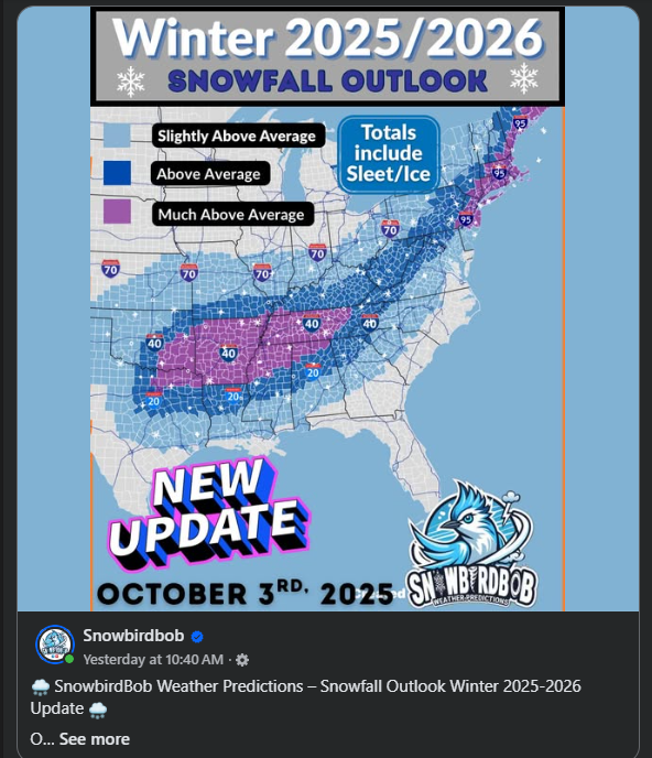
Look what I found! It's build up the subscribers season. Anyone ever heard of this guy?

-
Look what I spied with my little eye. Time to build up the subscribers! Who's SnowbirdBob?
-

Spooky Season (October Disco Thread)
CoastalWx replied to Prismshine Productions's topic in New England
What a waste to have a frost and then be 80F. Talk about fake. -

2025-2026 ENSO
40/70 Benchmark replied to 40/70 Benchmark's topic in Weather Forecasting and Discussion
This jives with my thoughts for January, as my analogs have a stratospheric reflection event getting underway around mid month, which will trigger strong AK ridging and a +TNH pattern, but those reflection events are preceded by Pacific trough patterns....hence +EPO. -
2025-2026 ENSO
40/70 Benchmark replied to 40/70 Benchmark's topic in Weather Forecasting and Discussion
I think that is pretty unlikely independent of GW.....that was an incredibly anomalous stretch that included 2 all-time record snowfall seasons. Let's not get trigger happy with GW attribution. -
Not to minimize TS Chantal, which caused record 24 hour rainfall in some portions of C NC, but will 2025 get through the rest of this season with no Conus hurricane impact for the first season since 2015? The record longest streak with a hurricane impact is 13 seasons (1938-50). -Since 1851 there have been 34 (20%) seasons with no Conus H impact on record. Of these 34, these were only 6 during La Niña (1872, 1890, 1892, 1973, 2000, and 2010) vs a much higher 15 during El Niño, which is intuitive. The highest ACE of these 34 was 2010’s 165 (La Niña) followed by 1951’s 126 (El Nino). -Since 1851 there have been only 6 (3%) seasons with a first Conus H impact on record in Oct or later: all were in Oct and none of these 6 had a second one. None were during La Niña. The highest ACE of these 6 was 1853’s 76 followed by 2002’s 68. So, if 2025 were to join them, it would by a good margin have the highest ACE of this group and would be the first during La Niña: 1853 neutral: Oct 20th (GA) when center passing 40 miles off GA from TC 1st reported ~NW Bahamas 1923 El Nino: Oct 16th (LA) from TCG in the EPAC! 1946 neutral: Oct 7th (W FL pen.) from TCG in NW Caribbean 1968 El Niño: Oct 18th (W FL pen.) from TCG in SW Caribbean (Gladys) 1987 El Niño: Oct 12th (Keys/S FL) from TCG in SW Caribbean (Floyd) 2002 El Niño: Oct 3rd (LA) from TCG in C MDR (Lili)
-
In January? Follow the flow. That better be cold enough with negative h5 heights just to our north under a -NAO. Otherwise we might as well just give up lol.
-
I’m getting some light to moderate showers that are moving W from off the ocean. First rain of the month. The forecast is for scattered showers to continue to occur in the area through the remainder of the night and through tomorrow. There could be a few thunderstorms tomorrow afternoon.
-

Spooky Season (October Disco Thread)
SnoSki14 replied to Prismshine Productions's topic in New England
But some will claim this is totally normal -
I think an oddball anomaly could still be possible in the snowier/colder direction that might generate this.
-
Might as well go 2017-2024. It’s not just since 2020 that things have been below average. It’s wild to think Baltimore hasn’t seen anything close to a real snowstorm in about 10 years, yet it feels like we’re punting on the odds of one occurring this upcoming winter. That’s not even negative thinking, it’s just realistic given the setup. Seems like even the most optimistic outlook would say we would need to piece together multiple different smaller events to get near or above average snowfall. I know a lot of us will still be hoping for a rare major snowstorm in a La Niña, and maybe the further we get away from January 2016, the more likely we get lucky with some funky setup just because we’re “due.” It just kind of sucks that hope is already pretty drained before we even get to November.


