All Activity
- Past hour
-
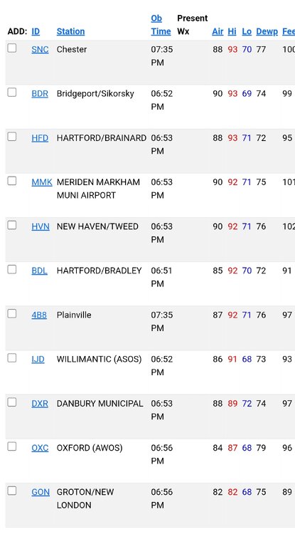
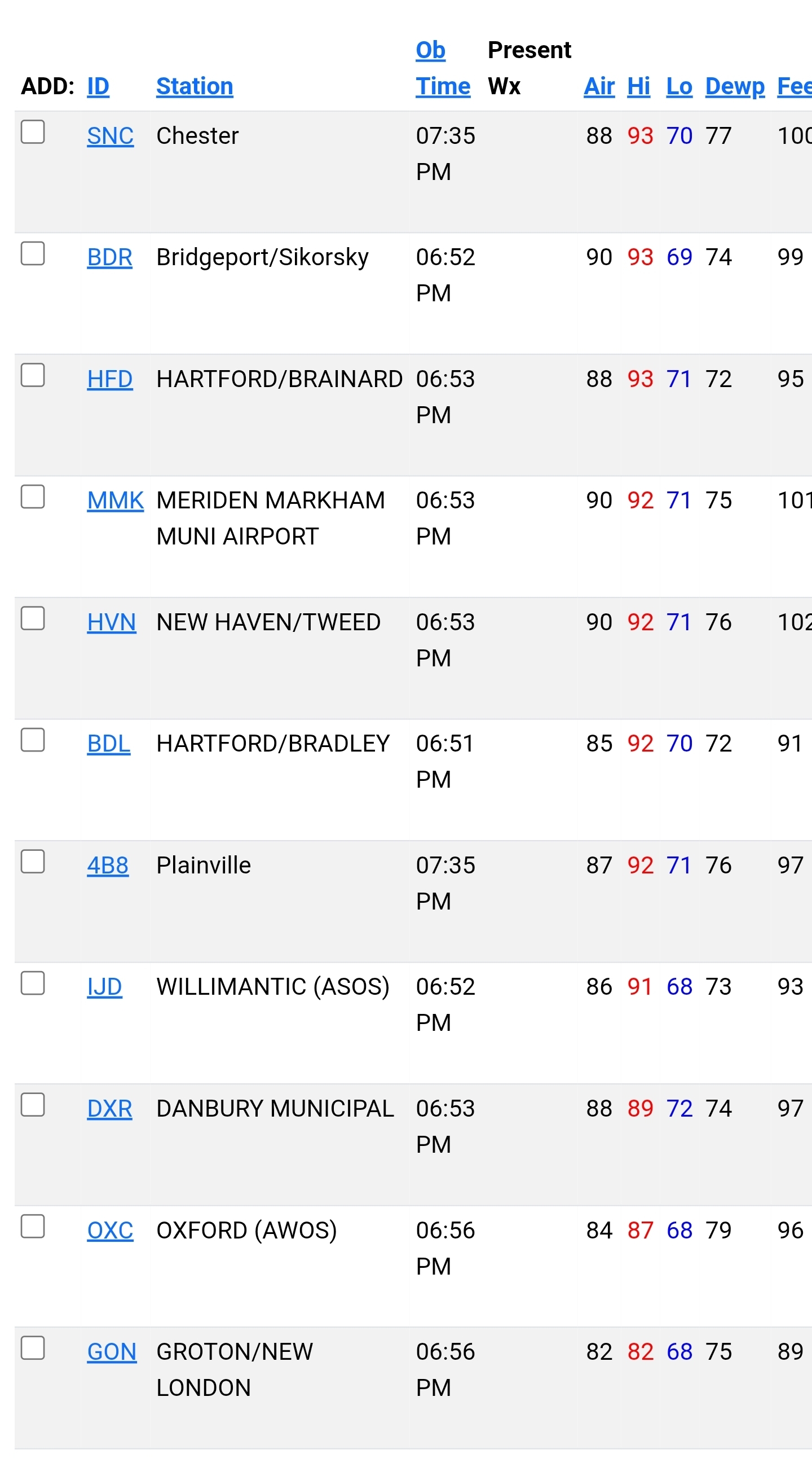
JFK Airport (91°), LaGuardia Airport (90°), and Newark (92°) all reached 90° or above while Central Park (88°) did not. That was the second time this month that happened. The last month with two such days was August 2021. The record is 4 such days from June 2010.
-
What a torch here on the shoreline to kick off summer. Highs for today.
-
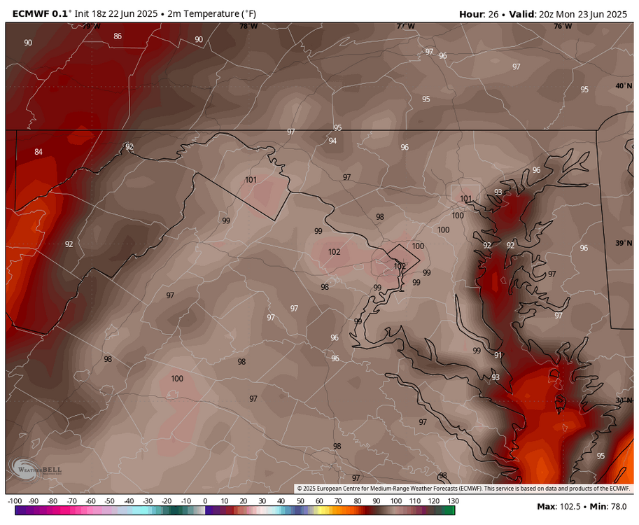
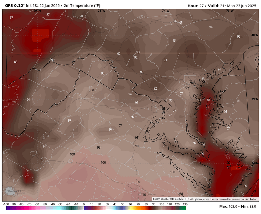
WB 18Z EURO 102 tomorrow; 18Z WB GFS 97 (I looked at 3-5pm).
-
I think it's from the buildup of a static charge in storm clouds?
- Yesterday
-
Rain? Sent from my SM-S921U using Tapatalk
-

June 2025 discussion-obs: Summerlike
PhiEaglesfan712 replied to wdrag's topic in New York City Metro
How is this even possible? -
Late high here of 89° off of the 0.08" of rain this am.
-
@FPizz I'm playing with you FYI Tuesday is 102 at LGA, 101 at JFK, 99 at Central Park. I think the "warmer" models verify on Tuesday
-
94 for the high. Currently 88
-
That wasn't his question Mr Pizz
-
I think they peaked at 87
-

E PA/NJ/DE Summer 2025 Obs/Discussion
JTA66 replied to Hurricane Agnes's topic in Philadelphia Region
I also topped out at 88F today. At least our rain-on-the-weekend streak survived. -

Central PA Summer 2025
Mount Joy Snowman replied to Voyager's topic in Upstate New York/Pennsylvania
I know a few people going to tonight’s game. Enjoy and stay cool! -

E PA/NJ/DE Summer 2025 Obs/Discussion
Hurricane Agnes replied to Hurricane Agnes's topic in Philadelphia Region
My temp finally recovered and I think 88 (finally hit around 6:30 pm) will be my final high for today, meaning starting over for tallying days towards an "official" heatwave IMBY (had a 90 yesterday). Ended up with 0.05" of rain from that band. Currently 87 with dp 78, so back in the oven again. ETA - was looking at the afternoon AFD and there was a mention of a pressure fall/rise and I did see that.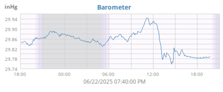
-

Mid to long range discussion- 2025
UnionCountyNCWX replied to wncsnow's topic in Southeastern States
When i was in high school in the mountains wearing them it was still hot. I can only imagine this kind of heat what it would feel like. -
Mid to long range discussion- 2025
UnionCountyNCWX replied to wncsnow's topic in Southeastern States
Weekly update: Weather: it's hot. Check in next week for the same thing lol. -
91 DCA 93 BWI 94 IAD
-
Most of the area didn't
-

2025-2026 ENSO
Stormchaserchuck1 replied to 40/70 Benchmark's topic in Weather Forecasting and Discussion
Yeah.. the issue is that the long term WPO since the 1940s has gone linearly from negative to positive, coinciding with global warming. It might be an issue of not enough data.. Will be interesting to see if we can get a longer term -WPO time in this warmer climate phase. I really like the high correlation SSTAs from the Indian Ocean to Western Pacific summer-fall before a WPO event.. it appears to be somewhat predictable. The SSTs currently favor more of a +WPO Winter, I agree, but I think post-2023/4 something shifted and we don't have as much of a pattern as 2018-2023. -
We hit 90 briefly around noon and then overcast the rest of the day. Clearing now, but the sun is already letting go of its grip on the day. Tomorrow might be pretty joyless with the heat index.
-
2025-2026 ENSO
Stormchaserchuck1 replied to 40/70 Benchmark's topic in Weather Forecasting and Discussion
Yeah, I think a hotter than average July appears likely, even vs the last 10-20 years. -
18z gfs gone wild for July 4th-5th.
-
Perfectly and eloquently stated. Deep summer is locked in
-
 Historically in such a scenario the coast hits 100 early on (12-1) and then temperatures start to drop after 3 pm.
 -
Historically in such a scenario the coast hits 100 early on (12-1) and then temperatures start to drop after 3 pm.


.thumb.png.4150b06c63a21f61052e47a612bf1818.png)


